Route 66 in Afton
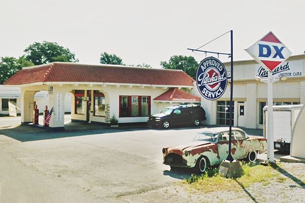
Historic Gas station
Index to this page

TheRoute-66.com is reader-supported. When you buy through links on our site, we may earn an affiliate commission at no additional cost to you.
About Afton, Oklahoma
Facts, Trivia and useful information
Elevation: 788 ft. (240 m). Population: 1,049 (2010 census).
Time zone: Central (CST): UTC minus 6 hours. Summer (DST) CDT (UTC-5).
Afton is located just south of I-44 on U.S. 66, in Ottawa County, northeastern corner of Oklahoma. Route 66 crosses it from east to west.
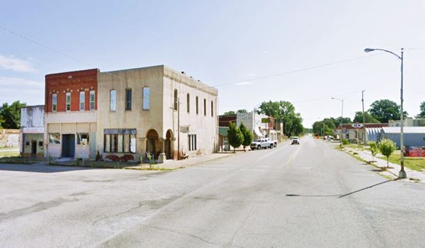
Main Street - Route 66 in Afton, Oklahoma. Showing Pierce Harvey Buggy Co. and Bassett's food store

Main Ave. and Route 66 in Afton, Oklahoma
Afton's History
Visit our Miami, History webpabe for complete information on Ottawa County's history.
The Name: Afton
The name Afton comes from a river in Ayrshire, Scotland, "River Afton" or "Afton Water". It became quite popular in a poem by Robert Burns (1759 - 1796) which in turn led to several American towns to be called after Afton.
One version is that a Scotsman named Anton Aires who was a railway surveyor named the station after his daughter (Afton).
It comes from the Gaelic language, with two variants: "afon" "abhainn" and both mean "water course".
Afton was a stop on the Atlantic and Pacific Railroad Company, which later became the St. Louis and San Francisco Railway ("Frisco") which laid its tracks through the region in 1871. A post office opened in 1886. A second line, the Kansas City, Fort Scott and Memphis Railroad opened a second line in 1901. A railway repair shop was built and the town flourished with its farming and railroad activities.
Route 66 was created in 1926 and its alignment included the nine-foot wide "Ribbon Road" which linked Afton to Miami as OK-7. This new highway link brought an inflow of travelers and more prosperity.
Motels, Courts and filling stations were built to cover the needs of these travelers. The Pensacola Dam was completed in 1940 and it created Lake O' Cherokees, which was also a tourist attraction.
However the railroad repair shop in Afton was closed and its roundhouse demolished in the 1930s.
As Route 66 became crowded and unsafe, a new highway was built and completed in 1957: the Will Rogers Turnpike or Interstate 44. It bypassed the town and relegated it to oblivion.

Where to Stay: Accommodation
You can find a room in Afton:
> > Book your Hotel in Afton
More Hotels
There are several hotels in the area close to Afton. Alternatively you can also lodge along Route 66 in the neighboring towns in Kansas, Missouri and Oklahoma.
Head East
- 15 mi. Miami
- 31 mi. Baxter Springs, Kansas
- 34 mi. Riverton
- 47 mi. Joplin
- 66 mi. Carthage
>> There are two RV campgrounds close to Afton.
Afton’s Weather

Location of Afton on Route 66
The average annual highs in Afton is 70.2°F (21°C), and the low is 47.2°F (8.4°C) and its mean annual temperature is 58.8°F (14.9°C).
During summer the avg. temperatures range from 92°F to 56°F (33.3 to 13.3 °C). The winter the range is 48°F to 24°F (8.9 to -4.4°C).
The average Number of Rain Days per year is 84, the most rainy months are March through June (with 8 days of rain per month). Yearly rainfall averages 44 inches (1.120 mm). Most rain falls during May, June and Sept. (over 5 in. or 125 mm during each of those months).
Snow falls in Afton, with about 11 inches (28 cm) per year between November and March, maximum snowfall has been 23 in. in one month (58 cm).
Tornados
Tornado Risk. Afton is in the Oklahoma "Tornado Alley and experiences about 9 Tornado watches every year. Read more about: Tornadoes on Route66.
Map of Route 66 through Afton
The first highways in the area were the car-worthy "Autotrails", the map below, was published in 1924 and shows the network in the region.
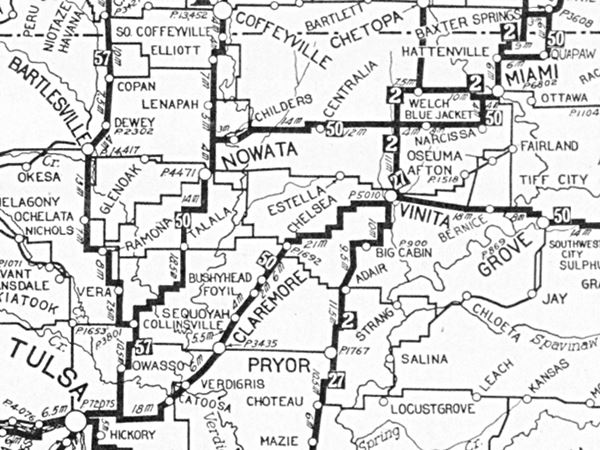
Afton is on the upper right side of the map close to Vinita. Notice that the highway marked as "50" was the "Ozark Trails" bypasses Afton. You can follow it from Baxter Springs KS to Tulsa OK.
The state paved the highway from Miami to Vinita, the famous "Ribbon Road" (a Nine-foot wide section known as the Ribbon Road or Sidewalk Road), and in 1926 Route 66 was aligned along it.
- 1926-37 alignment, following the Ribbon Road into Afton (map)
- 1937-85 alignment, slight changes on the eastern side of Afton (map)
Route 66 Alignment near Afton
Visit our pages with old maps and plenty of information of the old US 66 roadway.
- Vinita to Tulsa (next)
- KS-OK state line to Vinita (Afton's)
- Ribbon Road or Sidewalk Road (original).
- Route 66 in Kansas (previous)
Route 66 landmarks & attractions
Sights in Afton
The 1946 classic written by Jack DeVere Rittenhouse's "A Guide Book to Highway 66" tells us about Afton in those days after World War II.
... Pop. 1,261... Baker's Cafe; Northeast garage and Eagle Service Station Garage; Acme Court Rittenhouse, 1946
Of these , Acme Court has survived.
Town Attractions
We will begin our city tour of Afton on its eastern side, coming from Narcissa and Miami, and head west. The first stop is on the south side of the Interstate just past the cloverleaf interchange where US 60, 69, 59 (and old US66) meet.
Buffalo Ranch Trading Post Site
21600 U.S. 69 on the left side of the road. Buffalo Ranch was a Trading-Post that Russell and Aleene Kay opened in 1953. As an additional attraction they decided to raise bison (American buffalo). Their Western store included a restaurant and ice cream parlor (the "Dairy Ranch", which they sold to Betty Wheatlye in 1958. She ran it until 2000).

Buffalo Ranch, Afton. Credits. Click for St. view
The buffalo were a real crowd-drawer. Eastern folks would stop to see these typically Western animals.
Russell died in 1963, and despite slacker business after I-44 opened in 1957, his wife ran the ranch until her death in 1997. The store closed, the property was auctioned and the premises torn down in 2002. A new building was erected on the site housing a convenience store and restaurant open 24 ⁄ 7.
On the back side of the property, you can see a covered wagon, a gate with a totem pole, and a life-sized buffalo statue.
The now gone Green Acres Motel stood across the street. A new one (Route 66 Motel) has replaced it. Head west along Route 66. One mile ahead when you reach S520Rd., you will cross the "Ribbon Road", Route 66's 1926-37 alignment.
Ribbon Road and Marker
The narrow 1926 to 1937 U.S. 66 roadbed comes from the north (right), crosses modern US66, and then curves to the west (red arrows in the image below). On the curve is the marker. This is the westernmost tip of the Ribbon Road.
The marker reads:
In 1922 a new nine-foot wide roadway was completed between Miami and Afton, OK. Because no standards existed and so few roads were paved , its width was not unusual for the era. It consisted of a concrete base and edges with a surface of rock asphalt. In 1926 the "Sidewalk Highway" as it would be known was adopted by US 66.
Rt 66 was paved piecemeal from 1926 - 1937. Since the Miami to Afton section was paved it became the last segment upgraded to the standards established in 1930. It was also realigned and included a new bridge on the Neosho River.
On Sept. 12, 1937 the opening of the bridge completed the last RT 66 paving in Oklahoma. The "Sidewalk Highway" thus became one of the early stretches of Mother Road paving to be bypassed and today is the only RT 66 roadway of its type in existence.
The "Ribbon Road" close to Miami, OK.

> > Click to read about the Route 66: The Ribbon Road
The old roadbed crosses US66 west of this point and ran on its northern side, but nothing remains of this roadbed. Both met by the Horse Creek bridge, 0.7 mi. west.
Horse Creek Bridge
Listed in the National Register of Historic Places in 1995
It was built in 1936 by Pharaoh & Co. as part of the Public Works program during the Great Depression. It is unique because it has two pedestrian walkways protected by concrete guard rails (see red arrows in the image below).
The concrete bridge with steel girders has three spans and a total length of 143 ft.
Planners had expected the town to grow eastwards... but it didn't.
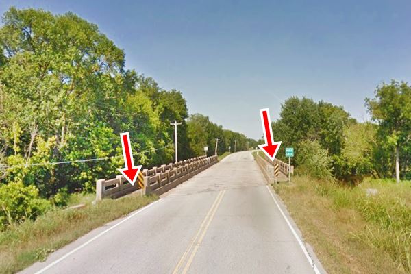
After the bridge, you enter the town of Afton. Ahead, to your left is a former gas station 2007 view and it has been repurposed as a restaurant (street view), the old gas pumps island has survived. Now it is "Nowhere on Route 66" at 300 SE 1st St. Top dish: Wood smoked barbecue.
Rest Haven Motel
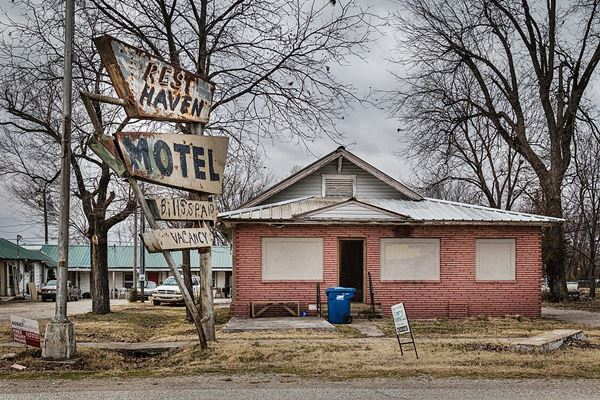
The old and now closed hotel is just ahead, to your right on the north side of Main Street just after Mulberry Ave. It has a great neon sign, fading and flaking away. The motel had an L-shaped layout with the office -now a home- in the middle; in the following image, the units can be seen on the left side of the property.
Palmer Hotel (Gone)

Palmer Hotel Neon sign, Afton. Credits
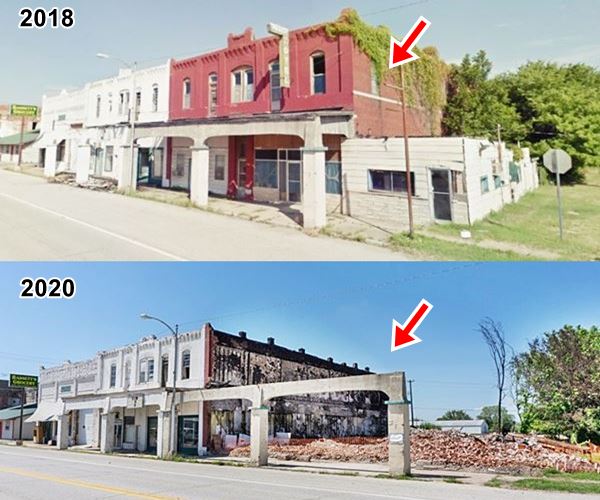
On the next block was the Palmer hotel. It burned and was torn down in June 2020.
The Palmer Hotel, was adjacent to the Palmer and Shelton Furniture Store in a building built in 1910. The hotel opened in the spring of 1911. An advertisement published in the Dec. 21, 1911 "Afton American" discloses that "Mrs. D.J. Matlock" was its "Propriertess"; its rates were $2.00 per day and it offered "the most home-like arrangements of any hotel in northeastern Oklahma. Hot and cold running water in each room. Electric lighted throughout. Dining Room Service of the best... Just opened. Two blocks from depot."
Matlock sold it to J. T. Hess in 1912, J. P. Carter was one of its owners until 1920.
Originally its customers were the railroad workers and staff. Then after Route 66 opened, it attracted those driving along the highway.
A cafe was added in 1940.
It was run by Alvin and Lulu Malone between 1952 and 1991, when it closed.
The sign and brick facade can be seen on the north side of the road in the following image in a "Then and Now" sequence.
Across the street, facing the former hotel site is the best known Route 66 attraction in Afton.
D-X Afton Service Station
First it was a Cities Service Station
Listed in the National Register of Historic Places
To your left, at 12 SE First Street. What is now a D-X station began as a Cities Service Station back in 1933.
It was an innovative building as it had two restrooms for its customers, in a period where many service stations had none (you can see them on both sides of the office).
It was a Mission Revival style building with a facade of rough textured stucco.
Originally it had two sets or arches and a double-lane canopy (see below -also notice the "Ladies" room, when it was a Spraker Station).
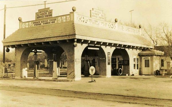
The service station sold different brands of gasoline over the years. It was the first 24-hours filling station on Route 66.
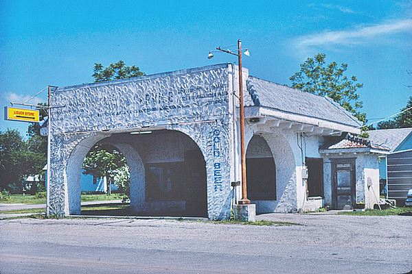
In the 1980s it still sold gasoline (D-X brand), but later closed. In 1999 it was purchased by former Connecticut residents Laurel and David Kane, who restored it and repurposed the building as the "Afton Station Packard Museum" adding a collection of classic cars, most of them Packards as well as Route 66 memorabilia.
Laurel passed away in 2016 and David died two years later. The property closed and was liquidated. Ths staton was auctioned in 2020.
Downtown sights, Rogers Motel
Bassett's Food Store is ahead, to your right. It closed in 2009 after operating for half a century. Housed in the early 1900s building built for the Pierce Harvey Buggy Co.
The Rogers Motel was located on Route 66 and S. Walnut, its postcard boasted "You are a stranger here but once". It was open at least until the 1970s, and later razed, the "Then and Now" sequence below shows that the office's foundations and the outline of the base of the neon sign have survived.

Rogers Motel 1950s postcard. Credits
Old Gas station
On the western side of S. Walnut, on the SW corner are the remains of a gas station. Its mansard roof canopy has been enclosed, but there are several service bays on the western side of the property. Ghost signs on the garage read "Lubrication Tires & Tubes - Batteries".
Gray Garage and Station
Two blocks west, to your left is another classic filling station. Gray Garage and Service Station is on the SW corner of S. Maple and U.S. 66.
It was built around 1930, and is also knwon as F.D. Mitchell Conoco Gas Station. It has a peculiar rock faced facade topped with dinosaur-like stone battlements.
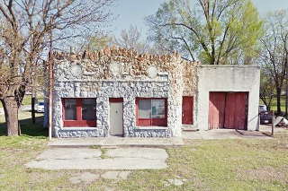
Another Vintage gas station
Across the road, just ahead, to your right is a box-shaped 1950s gas station with as single service bay, office and flat roof canopy held up by slender poles. Pictured below.
A Faded Neon Sign
Another vintage motel or cafe(?) once stood on the south side of Route 66, to your left at S. Downing Ave. (southwest corner). Next to what is now a home is what appears to be an old and now faded neon sign (see the red box in the image above).
Acme Courts
Head west, and when you reach S. Monroe Ave. to your left, on the south side of the highway is the site where an old motel or "tourist court" once stood, the Acme Courts.
Many online sources make the mistake of saying that Acme and Avon were the different names for the same place, this is not true. They were different businesses as you can see in the thumbnail image. Click on it to see a 1970 aerial photograph showing the Avon Courts and the now gone Acme Courts. Route 66 runs across the image diagonally.
US Post mail carrier Sullivan W. Johnson (1889-1962) and his wife Euretha Mae (1896-1976) chose the western part of Afton to open their Acme Courts in 1936. They had a Conoco Gasoline station next door. The postcard pictured below, from the period 1940 - 1949, informs on its back that: "The ACME COURTS provide the best in strictly modern over-nite cottages. A clean, comfortable place for you and your family. Play-ground for children. Reasonable rates. Our slogan - "You must be satisfied." Conoco Bronz-z-z Gasoline - New Nth Motor Oil."
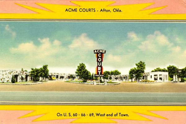
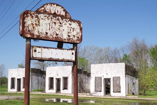
Nothing remains of the old motel. Across the highway, just ahead you will spot the ruins and neon sign of another motel.
Avon Court
John Foley opened Avon Court in 1936 it has seven units each of them with a covered carport. It was operated by W.R. Trebilcock between 1951 and 1955. Harry Glover ran it until 1958.
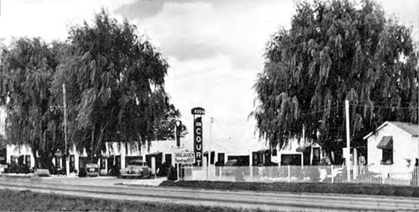
Avon Court (Motel) Route 66 in Afton, Oklahoma
Your Afton City Tour ends here.
Continue west for 4.5 miles (map with directions) to the infamous "Deadman Corner."
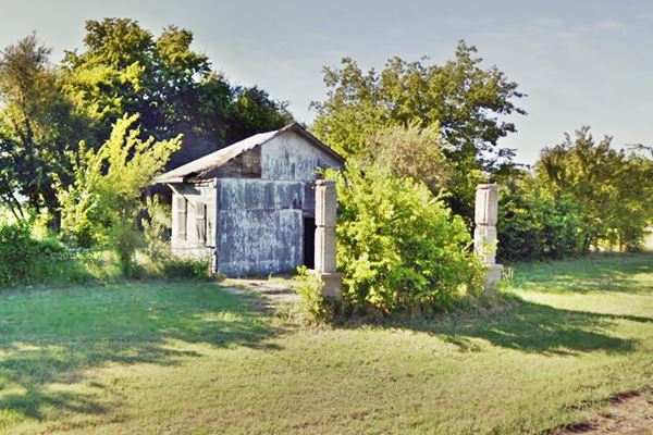
Deadmans corner, gas station and park
This is a sharp 90° curve where Route 66 changes its north-south course for a east-west one. Heavy traffic along US 60, 66 and 69 passed by here on a daily basis.
Rittenhouse wrote back in 1946 that five miles west of Afton "US 66 turns west at Lake Junction gas station (Right). On the left is a roadside park with tables." The old park is still there and also the gas station.
The station seems to have been a mid-1930s craftsman-style building with a gable roof, the canopy has vanished, but must have been gabled. It was held up by strong box-like columns that can still be seen.


Some sponsored content
> > Book your Hotel in Vinita


Credits
Banner image: Hackberry General Store, Hackberry, Arizona by Perla Eichenblat
Jack DeVere Rittenhouse, (1946). A Guide Book to Highway 66
Cities Service Hitoric Site Registration form. NPS
D-X station official website
D-X station blog


