Route 66 in Algodones NM
Index to this page
About Algodones, New Mexico
Facts, Trivia and useful information
Elevation: 5,112 ft (1,558 m). Population: 1,063 (2024).
Time zone: Mountain (MST): UTC minus 7 hours. Summer (DST) MDT (UTC-6).
Algodones is a census-designated-place and village in Sandoval County. It was located on the alignment of Route 66 from 1926 to 1937.
Camino Real and the Old 1926 Route 66 in Algodones
History
The Valley of the Rio Grande River has been inhabited for more than 10,000 years. The Native American farmers reached this area around 1200 AD, they speak an eastern dialect of the Keresan languages. They originally lived in Chaco Canyon and Mesa Verde, roughly 150 miles northwest of Algodones, but moved here escaping climate change and warfare.
They built their pueblos along the Rio Grande and used its water to irrigate their crops of corn and squash.
Francisco Vásquez de Coronado, a Spanish conquistador set out from Compostela, close to Puerto Vallarta in Mexico, in February 1540 to explore what is now Southwestern USA. He named the native people "Pueblo", after the Spanish word for "village". There was no gold and the Spaniards lost interest in the region for another 50 years.
The first "colonizing" expedition into New Mexico took place in 1590-91 and was lead by Gaspar Castaño de Sosa. His group reached Cerrillos and San Marcos Pueblo where the natives mined lead minerar to glaze their pottery. They also opened a cart trail to Santo Domingo Pueblo on the Rio Grande. Lacking royal approval, Sosa was arrested and his expedition was forced to return to Mexico.
However, the Catholic church wanted to convert the sedentary Indians and the Crown wanted to check the stories of gold and silver mines in the area so in 1595 Juan de Oñate was instructed to colonize the region. He set out in 1598, with men, women, cows, sheep and goats. He reported several Pueblo villages along the native trade route that bordered the Rio Grande River.
Later, the crown appointed Pedro de Peralta governor who replaced Oñate and he advanced north and founded Santa Fe in 1610. During the course of the XVIIth century, the Spanish established missions in the neighboring pueblos of San Felipe Pueblo and Santa Ana.
A route was opened, the "Camino Real" (or Royal Highway) that followed the Rio Grande and linked this area with Santa Fe in the north, and Mexico City, capital of the Viceroyalty of New Spain in the south.
Alphonse Bandelier, a Swiss-born American archaeologist reported in the 1880s that there was a nameless pueblo ruin opposite Algodones, meaning pehaps that the ruin was on the western side of the Rio Grande
The Encomienda system that forced the natives to work for their Spanish overlords plus the forced conversion to the Catholic religion led to a great rebellion (Pueblo Revolt) that took place in 1680. The natives expelled the opressive Spanish, and razed their towns and churches. However, freedom would be short lived. The Spaniards returned in 1692, defeated the rebels and resettled the area.
Santa Ana and San Felipe were rebuilt, and the site of La Angostura (The Narrows) became a strategic spot, the narrowing of the Rio Grande River at its junction with the Jemez. The ford here was fortified, and Algodones developed next to it in the 1700s.
Origin of the name Algodones
The name is the plural of the Spanish word (algodón) that means "cotton". It may be due to the fact that cotton was grown in this area (Keres and Tiwa districts) and sold to the other pueblos in the 1700s. But drought and raids by unfriendly natives led to its replacement with other crops.
This area was part of the province known as Tiguex by the Spanish.
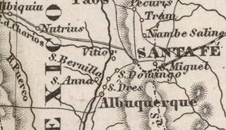
1852 map by J. Meyer
Click on image to enlarge.
Source
Until the early 1800s, the town was very probably known as Bernalillo (now further south). The thumbnail map published in 1852 (click on it to enlarge it) shows Santa Fe, and south of it Santo Domingo, S[anta] Anna and between them, S. Bernalilla (current Algodones), further south are S. Dres (Sandia?) and Albuquerque.
After its independence from Spain in 1821, Nueva Mexico passed on to Mexico, but lost it after the Mexican-American War (1846-48), ceding it to the United States. During this war, Algodones was described as follows: "the city of Algodones, containing 1000 inhabitants... is one of the handsomest towns in New Mexico. The vineyards, yards, pleasure grounds, orchards and gardens are walled in neatly."
It was the largest town in the region and a post office opened in Algodones in 1855, but it moved to Bernalillo in 1881.
The Atchison, Topeka and Santa Fe Railroad reached the area in the 1880s and built a stop in Algodones. In 1915 it was described as having 1,078 residents and "
Algodones (ahl-go-doe'nace) is a Mexican village which is an important center and shipping point for ranches and the sheep industry. The valley of the Rio Grande in this vicinity contains many large fields of alfalfa and other crops irrigated by water supplied by canals from the river."
Later, in 1926 Route 66 and U.S. Hwy. 85 were aligned through Algodones between Santa Fe and Albuquerque bringing tourists and prosperity to the region. But it would not last for long. In 1937 the Mother Road was realigned along a shorter alignment between Santa Rosa and Albuquerque and the "Santa Fe Cut-off" left Algodones in the backwaters again.
Where to Stay: Hotels
There is lodging along Route 66 near Algodones in Santa Fe and Albuquerque:
> > Book your Motel or Hotel nearby, in Santa Fe or Albuquerque
More Lodging close to Algodones on US 66
Below you will find a list some of the towns along Route 66 to the east and west of Algodones with hotels and accommodation; click on any of the links to find your hotel in these towns.
Heading West on the Main alignment
- 25 mi. Albuquerque
- 66 mi. Moriarty
- 82 mi. Acoma Pueblo
- 102 mi. Grants
- 164 mi. Gallup
Heading East main Route 66
- 138 mi. Santa Rosa
- 197 mi. Tucumcari
The Santa Fe Route 66 segment
- 40 mi. Santa Fe
- 99 mi. Las Vegas NM
Find your room in Santa Fe
Booking.com>> There are RV campgrounds near Algodones in Santa Fe and Albuquerque.
The weather in Algodones
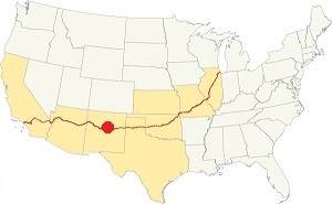
Location of Algodones on Route 66
The climate in Algodones is semi-arid, it has cold winters and hot summers. Altitude and the dry air cause large the daily temperature swings of around 25°F (14°C).
It is sunny (278 sunny days per year) and the relative humidity is low. The average High ⁄ Low Temperatures in summer (Jul.) are around 92 ⁄ and 65 °F (33 ⁄ 18 °C) respectively. The average in winter (Jan), are: 47 ⁄and 24 °F (8 ⁄ -4 °C)
Rain tends to fall during the summer monsoon season (July through September): about 11 in. per year (279 mm).
Snow falls between October and March with up to 23 inches (58 cm) yearly.
Tornado risk
The tornado risk in Algodones is nil, there are no tornado watches in Sandoval county.
Tornado Risk: read more about Tornado Risk along Route 66.
Map of Route 66 in Algodones, NM
Check out our interactive custom map showing Route 66's 1926-37 alignments in Algodones.
The original Route 66 was aligned through Algodones in 1926 along three previous highways, the "Ozark Trail", the "Santa Fe Trail" and the "National Old Trails".
These highways were known as "Auto Trails" and part of a public demand for "better roads": a movement that lobbied for good highways that could be used by motor vehicles, and also signs to mark them and help drivers to find their destination. New Mexico authorities improved the original Ozark Trail in 1914 and designated it as New Mexico State Highway 3. The thumbnail map (Click to see large size map), shows some of the "Auto Trails" that could be used by cars in 1912 in the area near Algodones (it appears as bearly legible on top of Bernalillo upper right side); the trails are marked with red lines.

1912 Road map, western NM
Click on image to enlarge.
Source

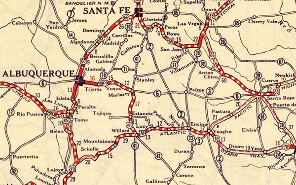
1925 Road map, western NM
Click on image to enlarge.
Source
The second thumbnail map above from 1925 (click on it to see the full sized map) shows the roads that existed one year before Route 66 was created.
Those marked "22" (National Old Trails Rd., coming from Los Angeles) and "32" (New Santa Fe Rd.) with white letters in a black box, went from Gallup to Albuquerque and through Santa Fe. Highway "50" was the Ozark Trails.
The only paved sections (full black line) were between Albuquerque and Bernalillo, and Albuquerque and Tijeras. The highway from Bernalillo to Santa Fe, and beyond Isleta was "improved" (dashed line), the rest were either graded or dirt roads. Algodones appears beneath San Felipe on the upper right side of the map.
The Santa Fe Loop (1926 - 1937)
This was the first alignment of Route 66, from Santa Rosa to Albuquerque via Pecos and Santa Fe.
We describe this segment in our Santa Fe Loop page, a dedicated webpage, with the full alignment, from Santa Rosa, through Dillia, Pecos, Santa Fe, Algodones, and Bernalillo all the way to Albuquerque.
This original highway also continued beyond Albuquerque to Isleta, Peralta and Mesita.
Algodones is on the upper left side:
1937 Realignment of Route 66
A political dispute between New Mexico Governor A. T. Hannett and local politicians led to the realignment of Route 66 in 1937.
Hannett blamed the local party bosses when he lost his 1927 bid to re-election. He decided to punish them, and their backers (the business men in Santa Fe) so he quickly had state highway #6 built, in 1927, to link Moriarty with Albuquerque. This highway bypassed the capital city, and was 90 miles shorter for those driving from the east to Albuquerque.
In 1937, the Federal roadbuilders decided to realign Route 66 using Hannett's road, and paved it. It was a straighter highway, and only had a short mountain segment across the Sandia Mountains between Sedillo, Tijeras and Carnuel.
Route 66 Alignment near Algodones
With maps and full information of the alignments of Rte. 66.
- Albuquerque to Lupton (next)
- Santa Rosa to Albuquerque 1937-85 (parallel)
- Tucumcari to Santa Rosa (previous)
The Santa Fe Loop (1926 - 1937)
Our Santa Fe Loop page describes the complete 1926 to 1937 alignment of Route 66 from Santa Rosa to Albuquerque through Pecos, Santa Fe and Bernalillo.
Algodones: its Attractions
Landmarks, Route 66 sights
Drive west towards Algodones from the previous town Santo Domingo (Kewa), the original 1926 to 32 alignment is almost completely gone, and the few spots where it can be driven are dirt trails. We marked the first segment from Santo Domingo to I-25 with a black line, it can't be driven, and ends at the Mormon Battalion Marker (blue marker in our map).
The Mormon Battalion Marker
New Mexico Historical Marker
12 mi. north of Algodones along I-25. Where the 1926-32 US 66 meets the later 1932-37 alignment.
The monument was erected in 1940, and can be seen on the north side of I-25 near Budaghers. It commemorates the march of a group of 500 men, mostly Mormon pioneers who marched from Council Bluffs, Iowa (July 16, 1846) to San Diego in California (Jan 29, 1847) during the Mexican American war. This is a distance of almost 2,000 miles. They were the Mormon Battalion
Route 66 alignments into Algodones
The later 1932-37 alignment is overlaid by the freeway all the way to San Felipe, and it is marked with a green line in our custom map.
Below we describe the earlier alignment.
The 1926-32 U.S. Hwy 66
This highway was originally dirt surfaced, unpaved, and has a winding course. Mostly a trace that can't be driven at all. The faint remains of it run along the north side of the freeway until it reaches the Arroyo Vega Tanos and crosses to the south side to ford it.
Little Gap
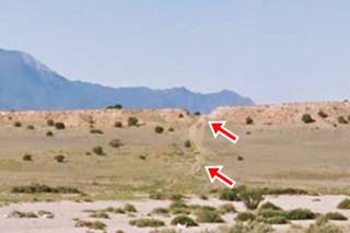
The highway then ran straight, cutting across the slope and ridge on the edge of a mesa on its southern side, this was known as the Little Gap (red arrows in image show cut and trail).
It continues straight across a flat area and becomes a dirt road that then meanders around some rough terrain as it approaches Arroyo Tonque. See the violet line in our custom map marking this segment.
Big Cut
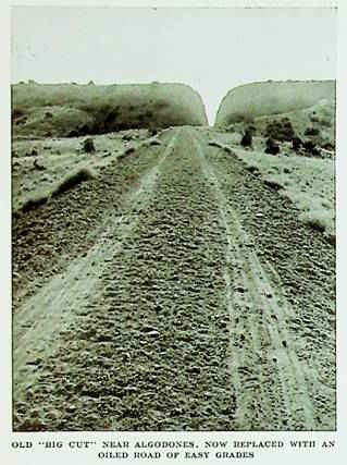
Big Cut, Oct. 1932 US66. Source
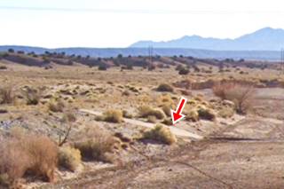
At the Arroyo Tonque, a wide gravel strewn river that is dry most of the year, the highway used a concrete slab ford to cross it. There are remains on both north and south side of the creek (pictured above).
The highway continued with a south course heading into the black mesa; across where the Casino complex is now located. See the teal line in our custom map.
This roadway is mostly gone, some traces remain like a culvert (see map) but it can't be driven. The famous "Big Cut" is located here. It was a deep narrow cut across a ridge.
The image from an article published in October 1932 is captioned "Old "Big Cut" near Algodones, now replaced with an oiled road of easy grades," referring to the new 1932 alignment that bypassed it. Notice the rough dirt surfaced roadway with tire tracks.
The image below is captioned "Automobile in gravel hill road cut betweeen Algodones and Santa Fe, New Mexico."
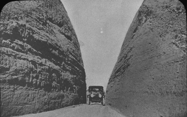
After the cut the highway crosses yet another dry creek (Arroyo San Francisco), it curves west along the south bank of the arroyo and then curved south again along the Camino Real between Pueblo San Felipe and Algodones. This last section of the old road is cut by I-25; here it met the 1932-37 alignment.
San Felipe Pueblo
Elevation 5,131 ft (1,564 m). Population (2024): 1,4308. See the Town's location. San Felipe Pueblo is located 6.5 miles north of Algodones, and can be reached from the freeway's Exit 252 (see the Map with directions).
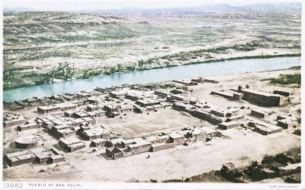
The village of San Felipe Pueblo (its name in the Eastern Keresian language is "Katishtya") is located on the western side of the Rio Grande river at the base of a high volcanic bluff.
The Pueblo, founded in 1706, after the Pueblo Revolt and its residents are Native Americans who speak an eastern dialect of the Keresan languages.
The village is very conservative from a cultural point of view and maintains its traditional customs and religion despite its closeness to Albuquerque, which is only 30 miles away.
What to see and do in San Felipe
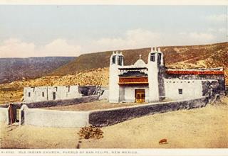
San Felipe Church. Source. Click to enlarge
The plaza is quite unique as it has been worn down over centuries of dances to its current level about 3 feet below the surrounding areas (1 m).
The best time to visit the Pueblo is on the Saint Philip (San Felipe) annual feast, held on May 1. San Felipe is the namesake and patron saint of the village and the Green Corn dances are the highlight. The San Pedro Day's festival is another key date to visit the town.
The annual arts and crafts show is held in October, a good opportunity to buy local crafts and jewelery. For those interested in crafts, the local beadwork, especially the heishe (small disc or tube shaped beads) can also be purchased at the gift shop. The tribe operates the Casino at I-25 plus a restaurant and gas station.
Important rules of etiquette during your visit to a Pueblo
Pueblos are on tribal lands and the local customs, religion and traditions must be respected.
- Check that access is allowed(leaders may restrict access for private ceremonies) and be prepared to pay an access fee
- Photography. Taking photos may be totally prohibited or a permit may be required. Check with the Tribal Office. Even if you have a permit, always request permission before taking a photo of a tribal member. Leave your cell phone out of sight and silence it, as it could be confiscated
- Lock vehicles, the pueblo is not responsible for any damages.
- Don't litter. Don't carry or use alcohol or drugs
- "Off Limits" signs must be respected. Don't remove artifacts or pottery shards
- Don't speed. Respect traffic signs
- Respect the local people. Dances are not a show, they are a ceremony. Show respect and remain silent at all ceremonies
- Cemeteries, Kivas, ceremonial rooms are sacred places and entry is not allowed for non-Pueblo people.
Head back towards the freeway to the Camino Real (map with directions) and head west to Algodones.
Camino Real
El Camino Real de Tierra Adentro National Historic Trail marked with a pale blue line in our custom map, is a historic route used since prehispanic times. It is in the process of nominating properties associated with it to the National Register of Historic Places.
The original trails date back to prehistoric times when turqouise mined in the region was traded with the Mesoamerican civilizations such as the Toltecs and the Aztecs.
Gaspar Castaño de Sosa used the trail in 1590-91 and Juan de Oñate in 1598. In 1610 Santa Fe became the capital of the Spanish province of Nuevo México and the trail became a lifeline linking it to Mexico.
Priests, traders, government officials, convicts and prisoners of war moved up and down it. Livestock and Goods were moved along the trail in caravans consisting of dozens of wagons; they could carry 4,000 lb. (1,800 kg) of merchandise and were pulled by eight mules.
German geographer, explorer and naturalist Alexander von Humboldt (1769 – 1859) mentioned it in 1804 during his travels in New Spain among thre four most important and most used roads for trade as "the road from Mexico City to Durango and to Santa Fe in New Mexico, popularly called el camino de tierra adentro." Camino de tierra adentro means the "inland road."
Despite its name "Royal" or "King's" highway, it wasn't commissioned by the Spanish Crown. Many roads used for trade in the Spanish American Empire, from Mexico to Peru, Chile, Argentina and Colombia were named royal highways. Tolls and custom tariffs were levied along them, but they were built by the local authorities.
In this area, it ran along the eastern side of the Rio Grande and passed through Sandia, Bernalillo and La Angostura. After passing by Algodones it reached San Felipe, that was on the western side of the River. There was a bridge here, built in 1791 that was washed away by 1846. Then it headed north to Santo Domingo (Kewa).
US.85 in the 1930s and 40s
US 66 and 85 went together along the Camino Real from 1926-37, and when Route 66 was realigned through Moriarty, U.S. 85 was promoted as"America's Oldest Road" as it ran along the historic El Camino Real and Santa Fe Trail. Traffic along this main highway linking Albuquerque and Santa Fe was good for local business, but when the road was realigned further east (now I-25) in 1955, all comercial enterprises in Algodones suffered the blow.
Algodones
The highway approaches the railroad and enters a farming area irrigated with the water from the Rio Grande in the fertile soil close to its course. You will see alfalfa growing in the fields and cattle grazing.
San Jose Mission Church
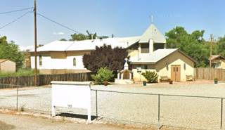
Between San Jose Rd. and Camino Real, on the north side of the village, below are a set of "Then and Now" pictures taken over 100 years apart. Notice the change in the steeple.
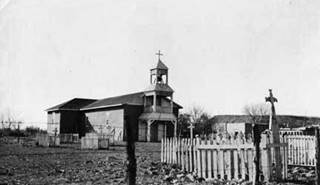
San Jose church, Algodones, 1920s. Source
Railroad Underpass
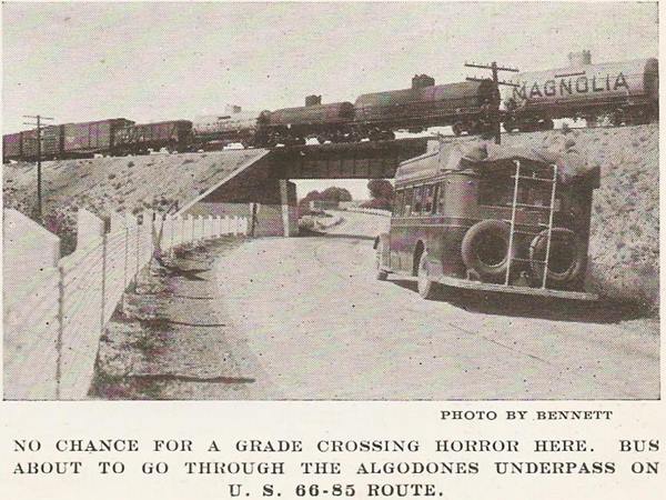
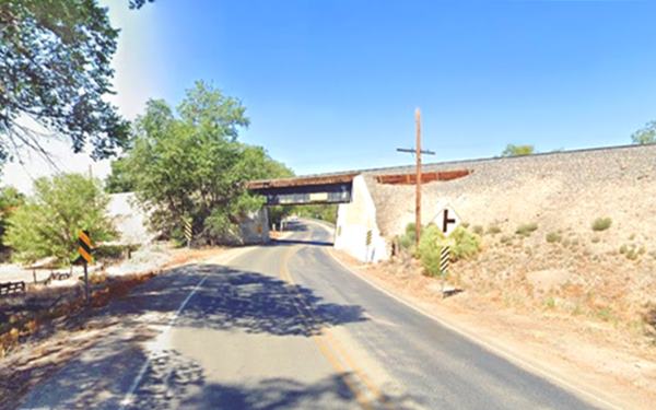
Drive west, after 0.7 mi. you will reach the railroad underpass, built in the 1930s to ensure a safe crossing of the AT&SF tracks. Below is an vintage picture captioned "No chance for a grade crossing horror here. Bus about to go through the Algodones Underpass on U.S. 66-85 Route."
La Angostura
After the underpass, the highway enters La Angostura.
Here the Rio Grande Valley becomes narrow ("angostura" in Spanish); this was a strategic pass as it controled the trade along the Camino Real and it was also the doorway to the Jemez river that meets the Rio Grande here. Furthermore, it was the frontier between the Queres (Keresan) natives of the Rio Grande as beyond the pass lies the land of the Tiguas (Tiwa) people.
Starting in the early 1600s shortly after Santa Fe was founded, the Spanish built levees here to manage the river. There are cliffs on the western side of the river, and gravelly bluffs to the east; this closes into a narrow pass (angostura) at this point. Control of this pass was critical to the safety of the trade along the Camino Real, so this area has been the focus of fortifications since the early 17th century. The place had been settled by Fernando Durá y Chaves prior to the 1680 revolt, who claimed to have lived on its western side, at a place called San Antonio de la Angostura. There had been a military post here, in the 1640s called Presidio de San Antonio that guarded the narrows against raids from the Apaches of the east. It was short lived. Don Diego de Vargas wrote in 1692 about an abandoned ranch here "Hacienda La Angostura." In the 1700s it was known as Angostura de Bernalillo, after the Bernal family who owned land here (see Bernalillo; Bernalillo is a diminutive of Bernal.)
There is a historic marker by the highway 0.2 mi west of the underpass, to your right (street view). It reads as follows:
La Angostura
Near here the Rio Grande Valley closes into a narrow pass (angostura). Control of this pass was critical to the safety of the trade along the Camino Real, so this area has been the focus of fortifications since the early 17th century. The 18th century settlement of Algodones developed as a result of continuing Spanish efforts to control the pass and nearby fords of the Rio Grande.
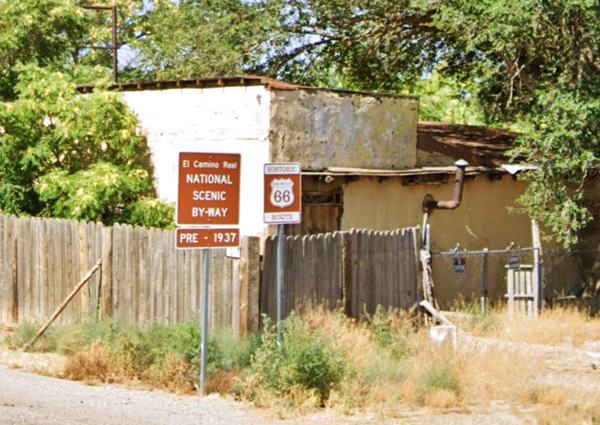
Forty yards west is a Historic Route 66 and Camino Real sign:
Timber Bridge (1927)
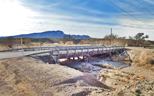
Drive west, ahead after the mile 13 signpost is a timber bridge built in 1927 to cross the Las Huertas Creek, it is a 3-span Steel Stringer and has wood piers and a timber deck onto which asphalt has been applied. Below is a view of it with the Sandia Mountains in the distance.
Ruiz
Roughly 1.5 miles west of the bridge, the AT&SF railroad built a depot. A 1915 account states that "Ruiz (rwees) is a contraction of the name of the Franciscan friar Rodríguez, who organized a small expedition from Mexico in 1581. On an exploring trip through the pueblos, he and two other Franciscans remained after the departure of their soldiers. The three friars were murdered by the Indians, Rodríguez being the last of the three. He was killed in this neighborhood, and his body was thrown into the Rio Grande, which was then in flood."
Another version says that Colonial records mention a Las Vegas de Ruiz
as a boundary (the meadows of Ruíz). By the way, Ruíz isn't the contraction of Rodríguez, instead it means "son of Ruy", the "-ez" suffix means "son of", and Ruy is a diminutive of the name Rodrigo (Roderick).
End of this leg of your Road Trip
Ruíz marks the end of this leg of your journey. Continue your road trip by heading west to your next stop on your road trip: Bernalillo, county seat of Sandoval County.

Some sponsored content
> > Book your Hotel in Santa Fe

Credits
Banner image: Hackberry General Store, Hackberry, California by Perla Eichenblat
Robert Julyan. 1996, The Place Names of New Mexico, UNM Press.


