Your Route 66 Road Trip through Arlington
Index to this page

TheRoute-66.com is reader-supported. When you buy through links on our site, we may earn an affiliate commission at no additional cost to you.
About Arlington Missouri
Facts, Trivia and useful information
Elevation: 689 ft (210 m). Population n⁄a (2010).
Time zone: Central (CST): UTC minus 6 hours. Summer (DST) CDT (UTC-5).
Arlington is an unincorporated community located next to the old US 66 in Phelps County, in the Ozarks in South central Missouri.
Main Street buildings in Arlington, Missouri

History of Arlington
For the general history of the area check the History of Rolla, the county seat.
James Harrison settled here in 1818, in what was known as "Little Piney" at the junction of the Little Piney and Gasconade Rivers, which was, for a short while, Crawford County seat. Arlington through time, was part of St. Louis, Gasconade, Carwford, Pulaski, and finally Phelps County.
When the St. Louis and San Francisco Railroad reached the area in 1867, Thomas Harrison, from Virginia platted the town on his father's land and named it Arlington. The post office which was open from 1868 to 1958 adopted the name.
The name: Arlington
Named after the plantation belonging to General R. E. Lee in Virginia, confiscated after the Civil War (now seat of the famous National Cemetery next to Washington DC). Thw name comes from the UK, where there are three towns with this name. It combines an ancient Anglo-Saxon name (Aelffrith, Aelfred, and Eorl) which now make the "Arl" part of the name, plus the word "-ing-", meaning associated with, and "tun", which meant "farm" or "settlement" in Old English. So it meant "Aelfred's farm", "Eorl's farm" or "Aellfrith's farm".
The "Wire Road" was built during the 1860s through Arlington, next to the telegraph line that ran from St. Louis to Fort Smith in Arkansas. The 1909 USGS map shows the Wire Road linking it with Rolla along Pea Ridge while another road linked it with Newburg along the Little Piney River valley following the railroad.
Later in the 1920s, the Wire Road was improved and became State Higway No. 14; in 1923 two steel bridges were built on it, one over the railway, the other across the Little Piney River, which runs just south of the town. The state highway became part of U.S. 66 in 1926. By 1946 it had become a ghost town and was bought by R. E. Carney, and later during the 1950s, Route 66 was upgraded to a four-lane freeway and its alignment straightened out, it bypassed the town completely, and later cut it off from the highway.

Where to Lodge in Arlington, Missouri
There are no hotels or motels in this small community, but you can find your accommodation nearby, in Rolla.
> > Book your hotel in neighboring Rolla
More Accommodation near Arlington along Route 66
Find lodging on the Route 66 towns east and west of Arlington. Check out hotels and motels by clicking on the links below to find a room in any of those towns.
Hotels Westwards, MO, KS, OK
- 15 mi. St. Robert
- 17 mi. Waynesville
- 50 mi. Lebanon
- 80 mi. Marshfield
- 92 mi. Strafford
- 105 mi. Springfield
- 165 mi. Carthage
- 182 mi. Joplin
- 198 mi. Baxter Springs
- 214 mi. Miami
- 229 mi. Afton
- 244 mi. Vinita
- 278 mi. Claremore
- 301 mi. Catoosa
- 304 mi. Tulsa
Accommodation eastwards in Missouri
- 13 mi. Rolla
- 24 mi. Saint James
- 38 mi. Cuba
- 56 mi. Sullivan
- 71 mi. Saint Clair
- 83 mi. Villa Ridge
- 90 mi. Pacific
- 100 mi. Eureka
- 117 mi. St. Louis
Hotels further East, in Illinois
- 122 mi. East St. Louis
- 129 mi. Granite City
- 131 mi. Pontoon Beach
- 138 mi. Glen Carbon
- 144 mi. Troy
- 149 mi. Edwardsville
- 157 mi. Hamel
- 166 mi. Williamson
Find your hotel in Rolla
Booking.com>> Check out the RV campground in neighboring Rolla
Weather in Arlington
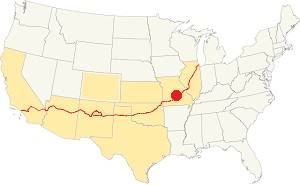
Location of Arlington on U.S. Hwy. 66
The weather in Arlington is a mix of both humid continental and humid subtropical climates. With well marked seasons. During winter (Jan), the average high is around 39°F (4°C) and the aveage low is a freezing 20°F (-7°C). The summer (Jul) average high is 89°F (32°C) with an average low of 68°F (20°C).
Rainfall average is 44.5 in. (1.130 mm) which ranges from 2.21 in (56 mm) in Jan. to 4.81 in (122.2 mm) in May. Snowfall is around 18.9 in. (48 cm), which falls from Dec. to Mar.
Tornado risk
Arlington is located in Missouri's "Tornado Alley" and Phelps County is hit by some 8 tornado strikes every year.
Tornado Risk: read more about Tornado Risk along Route66.
Map of Route 66 in Arlington MO
U.S. Highway 66's alignment through Arlington has changed many times over the course of time. Below is a summary of these changes. Read more about them in our Arlington - Jerome segment of Route 66 in the Rolla to Springfield alignment webpage.
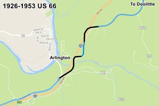
- From 1926 to 1953 Route 66 was a two-lane highway coming from Newburg (Map with alignment). It the curved towards Arlington and then crossed the Little Piney River using the 1923 bridge. The Pale Blue line marks the original 1926 to 1952 Route 66 that can still be driven. The Black segments have gone, either removed or buried under later roadbeds.
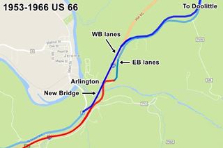
- 1953 to 1966 alignment: The highway was upgraded and became a four-lane highway. A completely new roadbed was built, shown in Blue in the map (click image to enlarge) it carried the westbound lanes. A new bridge was built to carry them across Piney river. The old alignment was linked to a new alignment (Red in the map) and it carried the eastbound lanes.
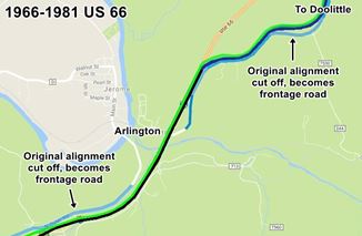
1966 - 1981 alignment: The old original steel bridge across Piney River was at the end of its life span so a new bridge was built to replace it and carry the eastbound lanes of US 66. At that time the road in Arlington was straightened out (Black) and linked to the former westbound lanes (Blue). The original eastbound lanes, what is now Outer Rd. W, became a frontage road that only gave access to Arlington (Pale Blue).
A completely new set of westbound lanes were built Green on the north side of Arlington and they met the older Westbound lanes there, and were carried over the Little Piney River by the 1953 bridge.
In 1967 the original (EB) bridge at Piney River was replaced. And in 1981, I-44 between Exit 176 and Arlington was realigned to the west of the older roadbed bypassing the old segment through Newburg. The old 1966 bridge on the WB lanes was replaced in 2009.
This is the map showing how to reach Arlington.
The Route 66 alignment in Arlington
Visit our pages with old maps and plenty of information about US 66's alignments.
- Springfield to Joplin (next)
- Rolla to Springfield (in Arlington)
- Gray Summit to Rolla (previous)
Route 66 Sights in Arlington
Landmarks and Places to See: A vanished town
Historic context, the classic Route 66 in Arlington
The 1941 book, "Missouri, a guide to the "Show Me" state" published by the WPA tells us that it "Arlington... (695 alt., 34 pop.), at the confluence of the Gasconade and Little Piney Rivers, is typical of the hamlets of the region... At present, it is an outfitting point for fishermen... boats and guides available", and Jack DeVere Rittenhouse in his "A Guide Book to Highway 66" published in 1946 also wrote about it.
ARLINGTON. (Pop 40...; no gas or other facilities.) Arlinton is a small, old-style village whose main street was cut off by a new highway... it nestles on the bank of the Little Piney River Rittenhouse (1946)
He added that Rowe Carney of Rolla had bought it that same year for ten thousand dollars to turn it into a resort. Which never happened. There was a gas station one mile east of it.
Your Route 66 road trip leg through Arlington
Begin your tour coming from Newburg, to do so leave I-44 at Exit 176 and drive down the old Route 66; this is the only access to Arlington; it is a dead end on what once was the 1926 to 1953 Route 66 alignment. See Map with directions. It is a short 2.9 miles drive west of Exit 176 - you will have to drive back the same way to continue your Route 66 road trip westwards into Jerome.
The old U.S. 66 in Arlington
The highway coming from Newburg turns 90° and heads south. The road has been realigned here (see our map section above for more details), originally the highway ran further west as shown in this Arlington US66 alignment map where the black line marks the original Route 66 that after 1953 became the eastbound lanes; the red line marks the 1953 westbound lanes. These alignments were eliminated when I-44 was realigned in 1981.
Beacon Motel site
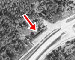
On the north side of Arlington, on the western side of the westbound lanes built in 1953, stood a long one-story building, the "Beacon Motel". You can still make out its foundations (satellite view). Click on the image to see the aerial photo from 1955, the red arrow marks the building, and the four-lane Route 66 curves to the right into Newburg. These lanes were razed when the modern freeway was built in 1981. The motel was located on the high ground where the airway beacon once stood, and gave it its name. The modern freeway is in a cut in the hill, so you can't see the spot from the interstate. It closed in 1968 and a brush fire burned it down in 2012.
Airway beacons were rotating lights on the top of a tower that aided visual navigation of airplanes along flight corridors.
Beacon Motel c.1950s; Route 66 Arlington
Driving into Arlington

Map of 1926-67 Route 66 in Arlington
There were other gas stations north of Arlington such as Johnson's Cafe, that sold Deep Rock gas, and the two-story Trucker's Home, that sold Skelly gas and also had a cafe and a hotel, both have vanished.
After the site of the motel, the original roadbed reappears and you can drive along it towards Arlington. It then curves into Arlington along the road built in 1967 shown in the image-map with the dashed yellow line, the "Modern Access Road"). But, at the spot marked (1) in the map, to your right you can make out the cut in the hillside where the original roadbed curved west towards Arlington.
You can see it in this map, marked with a black line. The roadbed has concrete curbs up to here, below you can see the curbs and the original alignment.
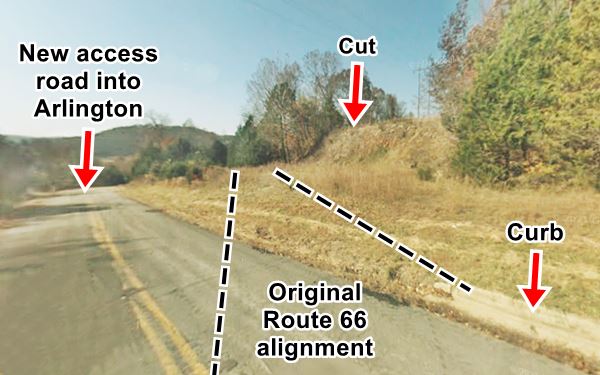
The original road from (1) to (3) has been removed and the freeway's eastbound lanes now run over the old highway.
Lost Landmarks in Arlington: Pillman's Camp site
The original access road into Arlington forked off from Route 66 at (2), and headed west into the village (orange line in image map and pink line in the interactive map). Pillman's camp, located at the fork was torn down when the 1953 set of lanes were built, but the road into Arlington survived until 1967 as a grade crossing across the highway. Then it was razed (red arrows in map).
This 1955 aerial photo shows the area after the new westbound lanes were built, Arlington is on the left and the "S" shaped original US66 is on the right; and the 1953 lanes run from the top to the bottom in the middle of the picture.
At the junction with the road into Arlington (2) on the west side of the curve, was Pillman's Camp, with a Café, cabins and a Phillips 66 gas station.
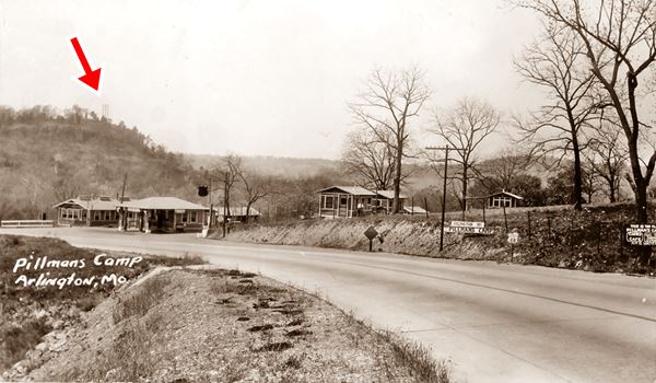
The image above looks west, notice how Route 66 curves towards the river (not in the image, to the left), to head towards Waynesville.
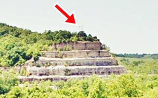
Now the freeway cuts across the site, but you can still see the wooded ridge in the distance (red arrow in the images), on the southern side of the Little Piney River with the three power line utility poles on its crest.
Pillman owned a general merchandise store and ran the local post office since the 1880s, catering to those who came by train to fish in the Gasconade River. By 1902 L. F. Pillman owned the "Inn" at Arlington renting rooms on a daily or weekly basis ($6 per week).
The town also had another campsite; the "Piney View Park and Cottages".
The ghost town
The town itself is just a short street on the dead end of Route 66. Attaway and Yost owned the Arlington Hotel here, next to the railroad depot. It opened in 1869 and survived into the 1900s. Now it is gone.
In Arlington, at the dead end of Route 66 there are a few buildings, pictured at the top of the page, formerly stores. The brick building on the left originally had a flat roof; the gable roof was added in the 2010s. Later it was a campground, but it closed.
The image below (click on it to see large sized picture) taken around 1930 looks east from the ridge (the one with the utility poles). You can see Arlington on the left, and behind it Route 66. After Pillman's was the old bridge across the railroad, built in 1923 (blue arrow in the middle) and the bridge across the Little Piney River (right, red arrow).
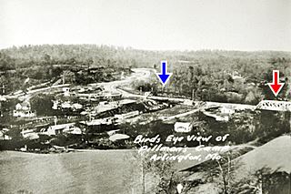
1923 US 66 Bridges at Arlington Missouri.
Click to enlarge. Credits
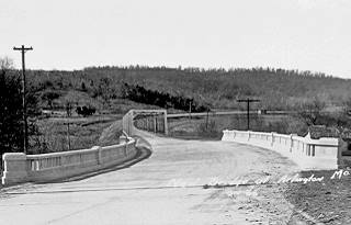
1932 Bridge at Arlington Missouri
Click to enlarge. Credits
The Railroad bridge was replaced in 1932 by a concrete one, see thumbnail image above (click on it to enlarge). It looks south, across the railroad bridge towards the steel bridge over the Little Piney River, marked with a (3) in the map further up.
1812 Log Court house (Gone)
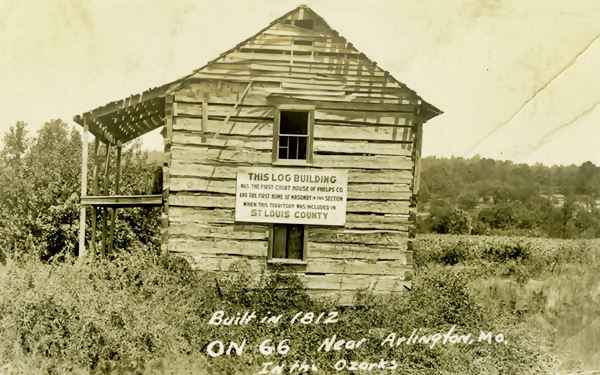
On the right side of the image, next to Route 66, that curves to the right, you can see the old "Court House" building.
There was a sign on the old courthouse that read "THIS BUILDING was the first court house of Phelps Co. and the first home of masonry in this section when this territory was included in ST LOUIS COUNTY".
It was built in 1812 and was washed away by a flood in 1943. It belonged to James Harrison, built with logs with mud chinking, it was also the stagecoach stop and local post office.
The court house was here (map).
Some Arlington Trivia
The Gasconade Dam
There was a proposal to dam the Gasconade River upstream from Arlington to obtain hydroelectric power and control flooding in the 1930s. But there were no funds for it due to the Great Depression and later World War II shelved the project.
Arlington's Prehistoric Stone Cairns

Photo taken in 1922 Rock cairn, Arlington
The Smithsonian Institution's Archeological Investigations (read the bulletin and see more photos) published in 1922, reported that 6 miles north of Arlington, at Sugar Tree Camp, on top of a cliff overlooking the Gasconade river, there are several stone cairns presumably of prehistoric origin. This is a map showing its location.
Your tour of Arlington ends here. Continue your Route 66 road trip by heading west along I-44, which is the only way to cross the river south of Arlington, and visit neighboring "Stonydell" in Jerome.

Some sponsored content
> > Book your hotel in Rolla


Credits
Banner image: Hackberry General Store, Hackberry, Arizona by Perla Eichenblat
Jack DeVere Rittenhouse, (1946). A Guide Book to Highway 66
Missouri: The WPA Guide to the "Show Me" State (1941)


