Your Route 66 Road Trip in Buckhorn
Index to this page

TheRoute-66.com is reader-supported. When you buy through links on our site, we may earn an affiliate commission at no additional cost to you.
About Buckhorn Missouri
Facts, Trivia and useful information
Elevation: 1,111 ft. ft (339 m). Population n⁄a (2010).
Time zone: Central (CST): UTC minus 6 hours. Summer (DST) CDT (UTC-5).
Buckhorn was a village located on old Route 66 in Pulaski County which in 2003 was annexed by neighboring Waynesville. It is located in the Ozarks in South-Central Missouri.
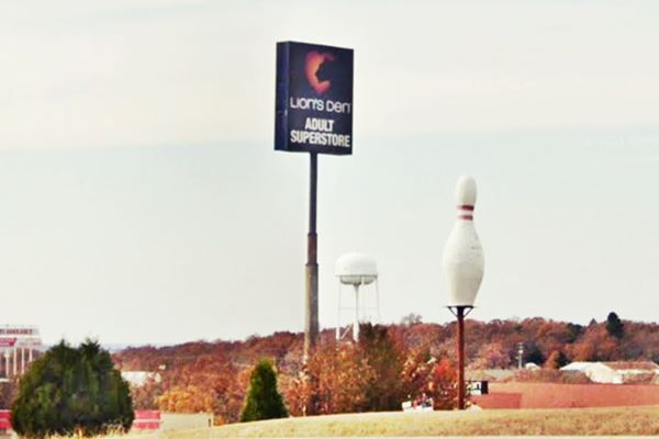
Buckhorn skyline US 66 in Buckhorn, Missouri: giant bowling pin, water tank and adult store sign.
History of Buckhorn
For the general history of the area check the History of Waynesville.
Pulaski County was created in 1833; it was named for a Polish patriot, Kazimierz Pułaski who died fighting during the American Revolution. People settled along the ancient Osage Trail, that crossed the area. Later, in the early 1860s, a telegraph line was built from St. Louis Missouri to Fort Smith in Arkansas and a road ran alongside it. This "Wire Road" passed by Buckhorn. Eventually it became the main road in the area.
There were other settlements in the region such as Debruin, close to present Buckhorn (now gone), Laquey, and other now defunct hamlets like Bellefonte, Flynn and Francis.
The name: Buckhorn
The original name of the area wa Pleasant Grove, but a stagecoach stop built here was known as Buckhorn Tavern because of a pair of large deer antlers on the tavern's sign. The name stuck and the area around it adopted it.
In the early 1910s, the "Old Wire Road" was improved and became Missouri State Hwy. 16, in 1926 Route 66 was aligned along it until the late 1950s when US 66 was improved, upgraded to a four-lane freeway and its alignment straightened out bypassing the town and slicing through the old Route 66 alignment at its eastern end.

Find your accommodation near Buckhorn
There are no hotels or motels in town, but there are many options nearby in neighboring Waynesville.
> > Book your hotel in Waynesville
More Hotels near Buckhorn
Below we list some of the towns along Route 66 with a link to their accommodation options. Click on any of the links to find your hotel in each of these towns.
Hotels Westwards, MO, KS, OK
- 27 mi. Lebanon
- 57 mi. Marshfield
- 69 mi. Strafford
- 82 mi. Springfield
- 142 mi. Carthage
- 159 mi. Joplin
- 175 mi. Baxter Springs
- 190 mi. Miami
- 206 mi. Afton
- 221 mi. Vinita
- 258 mi. Claremore
- 268 mi. Catoosa
- 281 mi. Tulsa
Accommodation Heading East in Missouri
- 6 mi. Waynesville
- 9 mi. Saint Robert
- 35 mi. Rolla
- 46 mi. Saint James
- 60 mi. Cuba
- 78 mi. Sullivan
- 93 mi. Saint Clair
- 105 mi. Villa Ridge
- 112 mi. Pacific
- 122 mi. Eureka
- 139 mi. St. Louis
Hotels further East, in Illinois
- 144 mi. East St. Louis
- 151 mi. Granite City
- 153 mi. Pontoon Beach
- 160 mi. Glen Carbon
- 161 mi. Troy
>> Check out the RV campground in neighboring Waynesville
The Weather in Buckhorn

Location of Buckhorn on U.S. Hwy. 66
There are clearly defined seasons in Waynesville and Buckhorn. During summer, the average high (Jul) is 88°F (31.2°C) and the average low is 67°F (19.2°C). During Winter (Jan) the average high is 42°F (5.6°C) and the average low is below freezing at 20°F (-7°C).
Rainfall on average is 44.5 in (1.131 mm) per year and falls regularly each month in roughly the same amount. Snowfall is about 9 in. (23 cm), and falls between Dec. and Mar.
Tornado risk
Buckhorn (now part of Waynesville) is located in the "Tornado Alley" and Pulaski County is hit by some 8 tornado strikes every year.
Tornado Risk: read more about Tornado Risk along Route66.
Map of Route 66 in Buckhorn MO
U.S. 66 Alignment and map
Until the 1950s, heading west from Wayensville, at the point where Old Route 66 meets I-44, it continued straight with a south course. But it is now cut by the freeway. It continued west and now is the southern frontage road of the interstat, Spruce Rd. and heads into Buckhorn where it curved south and ran along current MO-17 towards Laquey.
See this map of US 66 in Buckhorn.
In the early 1950s, the four-lane alignment was continued, bypassing Waynesville and following what is now I-44.
The maps in the image show the alignments before and after the four lane freeway was built. It was still named US 66. The original Route 66 was bypassed from Waynesville to Hazelgreen (present MO-17) as it was realigned along the 4-lane highway. Waynesville remained on the original Route 66, renamed "Highway T".
The Route 66 alignment in Buckhorn
Visit our pages, with old maps and plenty of information about US 66's alignments.
- Springfield to Joplin (next)
- Rolla to Springfield (Buckhorn's)
- Gray Summit to Rolla (previous)
Route 66 Sights in Buckhorn
Landmarks and Places to See during your Road Trip
Historic context, the classic Route 66 in Buckhorn
In his book "A Guide Book to Highway 66", published in 1946. Jack DeVere Rittenhouse gives us an idea of what Buckhorn was like in those days. He wrote the following.
... a small community here, with a few homes, gas stations, Bowden garage, and cafe... Rittenhouse (1946)
He added that one mile west "Gas station and a cafe here".
Tour Buckhorn
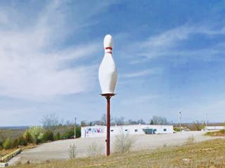
Drive west from Waynesville towards Buckhorn and Laquey. There are no existing landmarks along the original alignment, on the south side of the Freeway on Spruce Rd. So drive along MO-17 along the north side of I-44. You will reach a typical example of "Americana", a giant bowling pin on the right side of the highway. strictly speaking the attractions on this side of the highway are not part of historic Route 66, but they have a touch of Route 66 quirkyness.
Buckhorn Lanes Giant bowling pin
Americana - Route 66 Quirky stop.
25915 MO-17 just east of Exit 153, on its northern side is the bowling alley built by Ted Williams in 1976. The main attraction is its giant Bowling Pin which was once blown over by a storm.
Next to what is now the adult store once stood the "Ted Williams steak house", it was built in 1971 by a local named Ted Williams and had a gigantic black Angus bull on its roof, it closed for good in 2002 and was later torn down. Williams owned the bowling alley (the one with the giant bowling pin).
Head towards the Overpass, to your left is the site of the former Buckhorn Tavern that gave its name to the town (the tavern is no longer there), and also site of the now gone "Nickerson Farms ⁄ Witmor Farms. Torn down a few years ago.
Nickerson Farms ⁄ Witmor Farms (Gone)
At 25876 Red Oak Rd and Hwy. 17. To your right is what used to be Witmor Farms Restaurant, and before that, it was the second location of the Nickerson Farms chain.br/>It was a roadside restaurant franchise that operated between the early 1960s and the 1980s. It was the creation of I. J. Nickerson, and it grew to 60 restaurants in the Midwest, along the freeways. They also had a gas station selling Skelly gas.
Ray and Norma Moorman bought the place in 1963 renaming it "Witmor Farms".

Vintage postcard of Nickerson Farms, credits
Hogan Cemetery
This is a small cemetery right behind Witmor Farms. As it was vandalized in the 1970s only one original tombstone remains, that of N.J. Hogan (1822-1888), the others were replaced with concrete markers (see map).
Turn left, and head west into Buckhorn proper, crossing the freeway. To your left along Spruce Road is a Classic Motel on the old Route 66 1926-57 alignment.
S & G Motel
23000 Spruce Rd. (and Sumpter Drive.) Named after the initials of its owner "Steve Gounis".
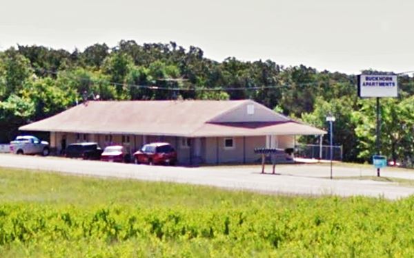
Gounis owned a first S &G motel west of Waynesville and after learning that US66 would bypass the town he moved to a new location on the four-lane Route 66 in Buckhorn. He purchased old barracks from Fort Leonard Wood (in neighboring St. Robert) and adapted them to make the hotel rooms. The gable roof building has survived as an apartment complex, the "Buckhorn apartments."
Its postcard (see below) announced: "S.G. Motel and Restaurant, Waynesville, Mo. - Rt. 66. (Interstate 44) at Rt 17 Interchange 7 miles west of Fort Leonard Wood - Modern Air-conditioned rooms with T.V. - Family Units and Apartments by Day, Week or Month."

S&G motel in the 1990s in Buckhorn MO on Route 66, credits

S&G motel color vintage postcard, credits
Here, where Spruce Road curves into Buckhorn, at one time there were several "classic buildings" but all of them have been torn down. They were: the Pleasant Grove Christian Church, built the same year Route 66 was created (1926), see a street view (2008) while it was still standing. Next to it was Stewart groceries and to the right was the former D & D Cafe and Market that began in 1941 as Upton's market and by 1947 was bought by the Deutschman brothers.
Drive west along Route 66 for 0.3 mi. to visit a classic Route 66 Court.
Bell Haven Court

Bell Haven gas station in the late 1940s, credits
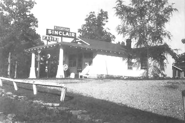
26367 Rte 66 - Highway 17. To your left. Originally named Hamilton's Pleasant Grove Cabins and built in 1932, it had a Sinclair gas station and five cabins at that time. See the photo below, from 1943, with the words "Pleasant Grove" above the canopy. At that time it was owned by Rudy and Clara Schuermann.
The Bell family purchased it in 1948 and renamed it Bell Haven Court. (See the other image from the late 1940s).
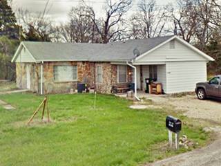
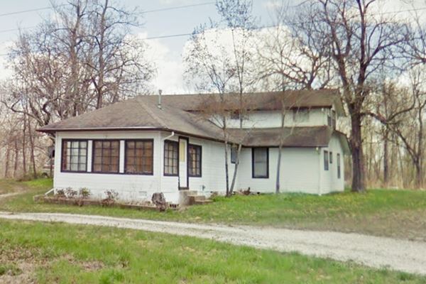
The cabins have all gone, but the former service station and office is still standing and became a private residence.
You can see, by comparing the "Then and Now" images below, that the former gas pump area under a flat canopy has been enclosed and the roof unified with that of the main building, as one single gable roof. A second story was added to the main building too.
View of the former Bell Haven Court today in Buckhorn, Missouri
Just ahead to your left was the site of the original Pleasant Grove school (1909), and the site of Hazel and Leland Hough's Market and Conoco gas station that they ran from 1946-1988. Both have gone.
Toops Souvenirs
What once was "Ozark Souvenirs" or "Toops Souvenirs of Ozark Handicraft", from 1947 to 1956. The building is still there, on the left side of the highway. It was the home of Ely Nelson Toops and his Minnie Lula (Boone) Toops. They also operated some cabins on their property. Pictured below.
Normandy hotel and restaurant

Normandy Hotel, credits
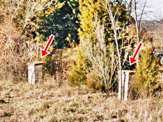
Normandy Hotel once stood 0.6 mi. west of Bell Haven, to your right. All that remains are two stone pillars that marked the entrance to the complex (see image above).
The complex included a gas station, hotel and restaurant. It was torn down around 1979. The quarry on the right side of the road marks its former location.
See a picture of the hotel below, built in stone, it had a tower with a cupola.
Sites of Hillcrest store and station, and Buffalo Lick Camp
Across the road, to your left, on the northeast corner of Route 66 and Shrine Rd., was a grocery shop and gas station named "Hillcrest" built in 1932. Shrine Rd. leads to the Pulaski County Fort Leonard Wood Shrine Club and Park, the largest outdoor venue in the region, it has camping areas, primitive RV and a club house.
Hillcrest was built by Vern Smith. It had a Knotex gas station, but it was torn down.
Across Shrine Rd. on the SE corner was the "Buffalo Lick" camp, it had cabins and was the "Home of Ozark Handicraft" it was owned my the Potts in the 1930s and by Mr. and Mrs. Johnson in 1946.
The camp was named afer a salt lick that was frequented by deer and buffalo.
Your city tour of Buckhorn ends here, you can continue your Route 66 road trip westwards towards Laquey.

Some sponsored content
> > Book your hotel in Lebanon


Credits
Banner image: Hackberry General Store, Hackberry, Arizona by Perla Eichenblat
Facebook Buckhorn memories
Jack DeVere Rittenhouse, (1946). A Guide Book to Highway 66
Architectural - Historic Survey of Route 66 in Missouri and Detailed Survey, Maura Johnson. 1993


