"Will Rogers Birthplace"
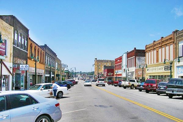
Main St. in Claremore's Historic Downtown district
Index to this page

TheRoute-66.com is reader-supported. When you buy through links on our site, we may earn an affiliate commission at no additional cost to you.
About Claremore, Oklahoma
Facts, Trivia and useful information
Elevation: 597 ft. (182 m). Population: 18,581 (2010 census).
Time zone: Central (CST): UTC minus 6 hours. Summer (DST) CDT (UTC-5).
Claremore is the county seat of Rogers County, Oklahoma and is located its south central region, on historic Route 66.

Claremore "Home of Radium Waters" postcard
Claremore's History
Northeastern Oklahoma has been inhabited for more than 10,000 years. Later, the Native American people hunted buffalo on the plains and the first to be encountered by western traders were the Osage Indians. The area of Claremore was first settled by the Osage tribe in 1802, their Chief Claremont chose a spot next to Claremore Mound, just north of the present-day town. However in 1817 the Cherokee attacked the settlement in the Battle of Claremore Mound killing many men and children, imprisioning the rest, and burning the village.
The current population of Cherokee is due to their relocation to the Indian Territories in the mid 1800s, in turn, the Osage were relocated in Kansas in 1838. The US government took the Cherokee Nation lands in the east and gave them new territory beyond the Mississippi River. The Indian Removal Act of 1830 resulted in a massive migration ("Trail of Tears") of the Cherokee Nation.
A second town was established in 1844, in the same place, and its first general store was owned by an Indian, John Bullette. It grew into a small town with 150 homes. Clem Rogers (father of the famous Will Rogers), moved there in 1856 and established a ranch which eventually had 60,000 acres.
There were some minor skirmishes during the American Civil War, and a stage coach mail line ran through the area; a post office was established in 1874. Finally, in 1882, the St. Louis and San Francisco Railroad advanced its tracks from Vinita nto the area and set up a stop naming it Claremore; Bullette moved his store to the new station. A second railroad (the St. Louis, Iron Mountain and Southern Railroad) reached the town in 1889.
The Name of the town: Claremore
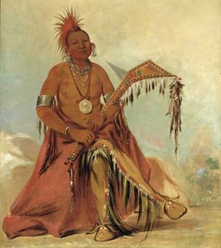
The town was to be named after the great Osage Chief "Gra-moi", which the French traders pronounced "Clermónt". He was painted by George Catlin (1796-1872) was an American artist, traveler and author. He visited the West frequently and painted portraits of Native Americans. He described Clermónt as follows:
The head-chief of the Osages at this time, is a young man by the name of Clermont, the son of a very distinguished chief of that name, who recently died; leaving his son his successor, with the consent of the tribe. I painted the portrait of this chief at full length, in a beautiful dress, his leggings fringed with scalp-locks, and in his hand his favourite and valued war-club. G. Catlin, Letters and Notes, vol. 2, no. 38, 1841
However, the telegraph operator misspelled "Clermont" and instead wrote "Claremore", so it became the name of the town. By the way, Clermont in French means "Clear Mountain". There is a town named Claremont on Route 66 in California.
The city was incorporated in the Cherokee Nation on May 2, 1903, and after statehood in 1907, it became County seat. When Route 66 was created in 1926, its alignment passed through the town of Claremore, bringing even more travelers to the town. Farming and ranching as well as the junction of two railroads promoted its growth. And the "radium water" soon attracted tourists.

Hotels in Claremore
Where to Stay
There are several hotels in Claremore.
> > Book your hotel in Claremore
Lodging Near Claremore
More accommodation nearby, along Route 66:
Find your room in Claremore
Booking.com>> There are several RV campgrounds in Claremore.
The Weather in Claremore

Location of Claremore on Route 66
The average high and low temperature in July are 69.5 and 92.8°F (20.8 - 30.2°C) while the winter (Jan) low and highs average 21.2 and 44.8°F (-6 and 7.1°C). Rainfall is 39.4 in. (1,001 mm) per year, and is fairly constant, the maximum rainfall takes place in May, June and Sept. each with 4.6 inches (117 mm).
Snow falls in Claremore during winter and about 5 inches (13 cm) can be expected between Nov. and March.
Claremore's Tornado Risk: The town is located in the "Tornado Alley and experiences about 8 Tornado watches every year. Read more about: Tornadoes on Route66.
Map of Route 66 in Claremore
Below is a map published in 1924, it shows the "Auto Trails" that were safe to be driven by car. It predates Route 66 by two years. Claremore in the middle of the map is located on a highway was marked as "50" which was the "Ozark Trails".
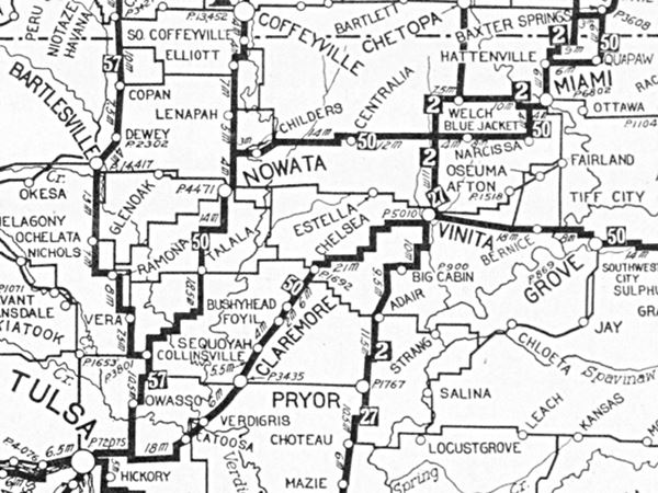
Map with the alignment of Route 66 through Claremore
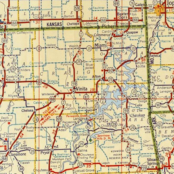
1948 Shell Roadmap northeast Oklahoma
Click on map to enlarge
Credits
The thumbnail shows a Shell Highway map (click it to enlarge the map) that dates back to 1948. It shows NE Oklahoma and SE Kansas. You can follow Route 66 from the upper right (Galena KS) to Claremore OK, located on the lower left corner.
You can check out Claremore on our Route 66 Map of Oklahoma webpage. It has all of the alignments of Route 66 in the state, and all the towns along them.
Route 66 was a dirt road when it was created in 1926. It was paved between Chelsea and Claremore with Portland cement in 1931, and it entered the town along J. M. Davis, and remained there until 1958. In July of that year it was moved one block to the east, along what
is now Lynn Riggs Blvd. a wide avenue, part of a new four lane alignment that was completed south of Claremore to Tulsa county. The old Route 66 became the westbound lanes of the new highway. North of Claremore the 5-lane highway was completed in 1960.
This is the 1926-58 alignment map in Claremore, and this
map shows the 1958-85 alignment of US66 in town.
Claremore Trivia Route 66 and Lynn Riggs Blvd
Route 66 runs along Rollie Lynn Riggs Boulevard. Riggs was born in Claremore in 1899 wrote a play (Green Grow the Lilacs, 1931), which was later adapted by Rodgers and Hammerstein into the famous musical "Oklahoma!". The play is set in Claremore and its surrounding area in 1906 and many characters were based on Riggs' family members and friends. There is a Lynn Riggs Memorial inside the Claremore Museum of History as well as a special exhibit.
Route 66 Alignment near Claremore
Visit our pages with old maps and plenty of information of the old US 66 roadway.
- Tulsa to Chandler (next)
- Vinita to Tulsa (Claremore's)
- KS-OK state line to Vinita (previous)
Route 66 landmarks & attractions
Sights in Claremore
- In Claremore. Read on below
- Tours & Itineraries
- State Parks
Claremore's Landmarks
The town is located in "Green Country", the northeastern corner of Oklahoma, with plenty of trees and hills. "A Guide Book to Highway 66" written in 1946 by Jack DeVere Rittenhouse gives us a good idea of the Mother Road during its heyday. He tells us about Claremore: it had a 6,000 residents and the "hotels: Mason, Will Rogers, Sequoyah; courts: El Sueno and Cozy Court; Randle & Munson garage; all facilities" he mentioned the radium water baths and a gun collection (largest in the world) of J. M. Davis; and of course the Will Rogers Memorial.
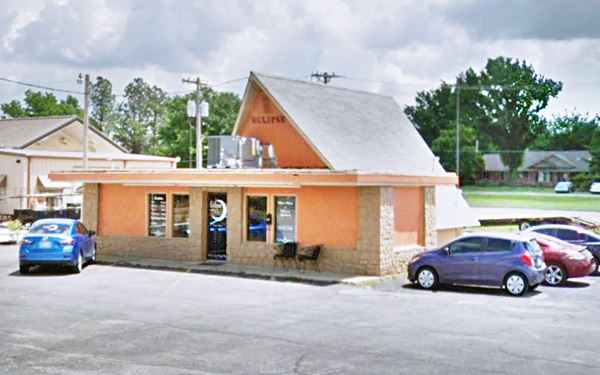
Begin your city tour on the northern side of town on Route 66 where the 1926 alignment splits to the right of the later 1950s four lane alignment (see map). Drive west along the original Route 66 alignment. To your right is the old St. Louis and San Francisco Railroad. Take a left along W 12th St. to North Lynn Riggs Blvd (the 1950s Route 66) and on its NE corner you will see what once was a "1960s Fast Food restaurant".
Mr. Swiss
Mr. Swiss company opened in 1964 and was based in Oklahoma City, OK; it was a chain that sold soft-serve ice cream, hamburgers and sandwiches. Ran by L.J. Doerfler it grew to almost 200 stores in 38 states but went bust in the 1970s. You can recognize its A-frame buildings. There are two of the former stores on Route 66 in Missouri, the Mr. Swiss in Joplin, and the Mr. Swiss in Lebanon, and another one in Oklahoma City.
Will Rogers Home Town Marker
Half a block south, on the median strip of North Lynn Riggs Blvd between 12th and 11th streets is the marker proclaiming "Will Rogers Home Town", see street view.
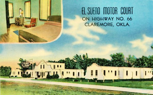
Head back to old Route 66 (J M Davis Blvd), turn left and resume your southbound journey. After 0.4 miles, to your left, just after W 7th St, at 402 N J. M. Davis Blvd. you will see the first classic motel was mentioned by Rittenhouse, "El Sueno".
El Sueno Court
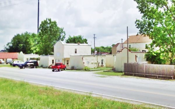
The old "El Sueno Motor Court" (Sueno or better said "Sueño" means sleep or dreams in Spanish) it was built in a Spanish colonial style and is still standing, with some minor changes and is now an apartment complex named Adobe Village. The postcard below boasted "Claremore's Finest. 18 modern, steam heated units- On Highway No. 66, 3 blocks from business district. 5 minutes to Will Rogers Memorial, and Oklahoma Military Academy. Close to all Bath Houses."
On the next block to your left is the museum that houses the "gun collection" mentioned by Rittenhouse in 1946.
J.M. Davis Arms & Historical Museum
330 North JM Davis Boulevard (yes, the old Route 66 was named after Mr. John Monroe Davis), to your left. Visit the museum's website www.thegunmuseum.com
The world's largest collection of guns (more than 14,000 are on display). It exhibits 50,000 artifacts including saddles, swords, indian artifacts, and musical instruments.
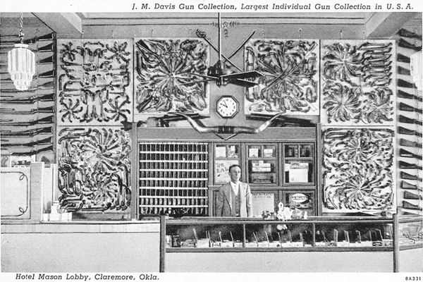
John Monroe Davis (1887-1973) received his first gun when he was 7 years old, and began collectign them. His first exhibit was on the walls of his Mason Motel in Claremore, which he bought in 1919. Being a Route 66 hotel, the collection attracted many visitors. Davis later leased and willed the collection to the State of Oklahoma. It built a modern facility to house it. Davis died in 1973 and is buried on the museum grounds. The Mason was razed in 1986.
Will Rogers Marker
Don't miss the Will Rogers marker on the corner of Route 66 1950s alignment, next to the tank, by the entrance to the museum. It gives a brief bio of Rogers, see its St. view.
1930s Johnson's Conoco Station

Typical 1930s Conoco gas station
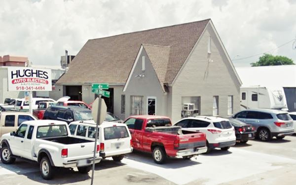
One block ahead, on the NE corner of W 4th St. is a classic cottage-style Conoco gas station from the 1930s ; now it is a garage. The building has a double garage bay, and a steep pitched cross
gabled roof.
Several oil companies favored this design between 1920 and 1950, Conoco, Enco, Texaco, Phillips 66, and Cities Service. This one however is clearly a
Conoco. Conoco built Tudor Revival-style stations between 1930 and 1940 (see postcard), they can be distinguished because they had an inner chimney and narrow vents or windows in the gable ends, like the ones in this former station, which lacks the chimney.
Humble or Magnolia station from the 1920s
Across the street, on the SE corner is yet another vintage gas station from the 1930s. This former gas station is now a car dealership, and the original building was modernized and altered a few years ago, when the original office was torn down. You can still see the garage bays with pillasters on their walls. The street view from 2011 shows the low-pitched hipped roof with four sides that was used by both Humble Oil (1920-1940) and Magnolia (1918-20s). The office and garage facing Route 66 were demolished as you can see in the sequence below. The red arrow marks the building that remained, those in front of it have gone.
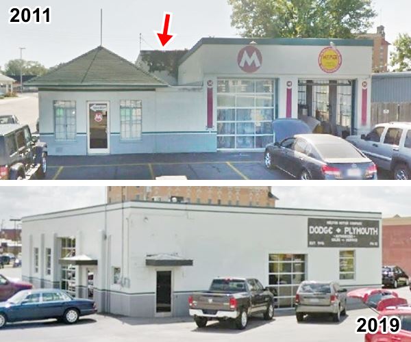
Head south along Route 66 and at 103 S J.M. Davis Blvd. on the SW corner is a 1940s stone building.
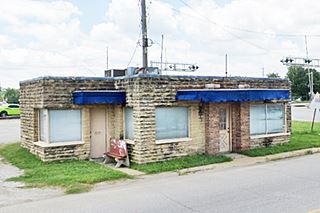
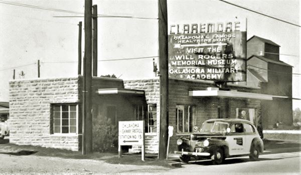
1940 Public Information Building
Built with rustic local stone, this one-story building served as a Public Information office. There is a bronze shield on its NE corner, which reads "USA 1940 WPA Oklahoma". The WPA was a New Deal
administration that created jobs during the Great Depression with construction and building projects.
The image shows a Oklahoma Highway Patrol unit (Ford 1937) parked next to the building.
There are no other attractions along the old Route 66 south of this point. Take a short 4.7 mile round-trip tour to visit the other sights in Claremore (map with directions). As you tak a left along W Will Rogers Blvd, the main street in Claremore, to your left you will see the classic Will Rogers Hotel mentioned by Rittenhouse in 1946.
The Will Rogers Hotel
Listed in the National Register of Historic Places

Hotel Will Rogers, Claremore, ca. 1930s postcard
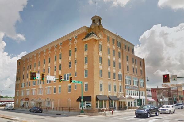
At 524 W. Will Rogers Blvd. This box-like building designed in the Spanish Colonial Revival style, was constructed in 1930 while Will Rogers was still alive. The hotel featured "The Eastern Atmosphere, Western Welcome and Southern Hospitality".
It is a six-story structure which had 78 rooms and 7 apartments. It was the last and largest hotel to be built in town. Its steel and concrete skeleton led it to be designated as a bomb sheleter during World War II.
Built on a corner and facing Route 66 it catered to travelers along the mother road and to those seeking the curative power of "Radium Water Baths". There is a statue of Will Rogers in the lobby and its interior decoration is clearly American Southwest style. On the second floor is the ballroom and the baths, shower rooms and sun deck were located on the sixth floor.
It closed in the 1980s and was rehabilitated in 1997. Visitors are welcome to visit the lobby and second floor.
Historic Downtown Claremore
Over 250 antique dealers, coffee shops, and places to eat. Housed in early 1900s red-brick stores, with a wide range of collectibles, antiques, and art. Park your car and take a stroll.
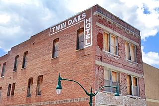
Twin Oaks Hotel
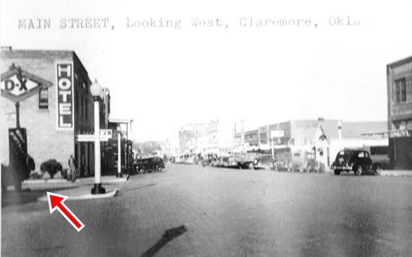
To your right, at 319 Will Rogers is an old hotel. The three story building was built in 1908 by Mrs. Schmitz as the Schmitz Hotel. After she married Mr. Bird, it became the "Bird Hotel" in 1915 ("European... with hot and cold water in every room"). Then it was the Saratoga and finally around 1924 it became the "Twin Oaks Hotel". At that time it had a balcony over the sidewalk, which you can see in the DX image further down, beyond the DX sign, to the left.
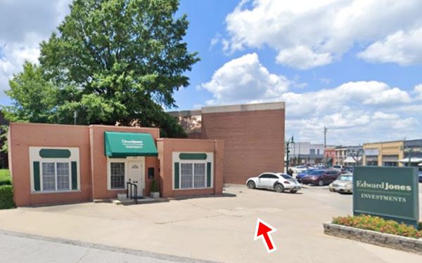
Lingenfelter DX station
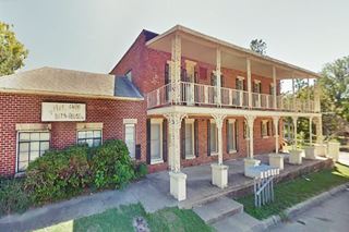
Ralph Lingenfelter DX opened in 1934 and closed in 1970. The red-brick one story building on the SW corner of 3rd and Muskogee (301 W Will Rogers) was, at one time a DX gas station. The office seems to have been on the right side, facing the spot where the gas pumps island ones stood (you can make out its outline in the concrete paving see red arrow in the image below). The left side is higher and must have been the garage bays. All windows and main door are later additions. The Sanborn Fire Insurance Map of 1933 shows the filling station there.
Below is a 1930s photo with the DX sign on the corner (red arrow), looking west along Will Rogers.
Belvidere Mansion
4th & Chickasaw, Claremore, OK.
Listed in the National Register of Historic Places
John M. Bayless and his wife Mary moved to the Indian Territory from Caseville Missouri in 1901, and began building the mansion the following year. The house was completed in 1907.
A great part of the woodwork and trim were brought from the St. Louis 1904 World Fair. Its name comes from the Italian words "belvedere" or "belvidere" which mean "fair view".
It is a three-story construction with brick walls and tile roof. It has four towers, placed at the corners and a portico on its north side.
Open for tours, dining in the Tea Room or shopping.

Belvidere Mansion nowadays. Credits

Belvidere Mansion nowadays. Click for St. view. Credits
One block west is the History Museum:
Claremore Museum of History
At 121 N. Weenonah, one block west of the Mansion, with exhibits of the town's past: historic artifacts, Route 66, famous people from Claremore and old downtown. It is housed in the former Will Rogers Library, a classic building (Street view).
Visit the only remaining "Bath house" in Claremore.
Radium Water Baths

A Radium Bath token, Credits
One of Claremore's promoters, George Washington Eaton while drilling for oil in 1903 discovered a spring of water with a very foul smell of rotten eggs. Eaton discarded the water in a stream and he saw a mangy dog frolicking in the water which the next day was cured. Eaton quickly realized its potential and promoted it as a cure for all kinds of ailments from stomach problem and dandruff to eczema or rheumatism.
Eaton proclaimed that the foul smelling water was "Radium water"; in fact it had no radium. The source of its smell was sulfur and hydrogen sulfide.
Radium is a chemical element (Ra) which is highly radioactive. It was discovered by Marie and Pierre Curie in 1898 and was popular at that time and promoted as a cure for many diseases. Tourists began to arrive by rail to take baths. The first bathouse was built in 1904 and it drew crowds. People came from all over the world. The section where the baths were located became known as "Radium Town", it was just one mile north of town (between present day Seminole and Dorothy Avenues along 9th St). It was good for business, hotels were full and merchants catered to the tourists.
Little remains of the bath houses, but you can visit the only standing one, "Mendenhalls".
Mendenhalls Bath House
Historic Site Oklahoma's National Register of Historic Places
At 7th St. and Lavira. Watson J. Mendenhall opened it back in 1905 as the Mendenhall Radium Water Baths, it had a two story building that is still standing. The baths were later operated
by Bob and Patsy Keller as "Keller's Bath House" which closed in 1980. Now it is an apartment complex.
The postcard below says that "Radium Water cures rheumatism, eczema, stomach trouble, skin disease, etc...".

Mendenhall's bath house 1910s. Credits
Continue your tour by heading west to visit the memorial to the town's prodigal son, Will Rogers.
Will Rogers, Oklahoma's Favorite Son

Will Rogers Credits
William Penn Adair "Will" Rogers was born in 1879 at his family's ranch, (Dog Iron Ranch) in what would later become Oologah, in Claremore, Oklahoma. He was a Cherokee Indian, a cowboy and also a movie star, an entertainer. He was a Brodway actor, a writer, philosopher and comedian.
His father, Clement Vann Rogers was a Cherokee Nation Senator and a judge. He helped write the Oklahoma Constitution. His mother was Mary America Schrimsher Rogers, who descended from a Cherokee chief. He had eight brothers and sisters, four of them died in their childhood.
Rogers joked that his ancestors did not come over on the Mayflower, but they "met the boat".
On the ranch he learned how to rope cattle and became a cowboy.
During his career in the 1920s and 1930s he made 71 movies and wrote over 4,000 newspaper columns. He was a world famous star.
He died in an airplane crash in Alaska in 1935.
Many memorials remember him across the nation, the I-44 turnpike in Oklahoma bears his name as does U.S. Route 66, the "Will Rogers Highway" (there is a plaque dedicating the highway to him, just next to its western terminus in Santa Monica, California).
Will Rogers Memorial Museum
1720 West Will Rogers Blvd. The twenty acres site on a hill overlooks the town, and houses the Will Rogers Museum and his tomb, where he was buried in 1944.
His wife Betty (1879 - 1944) and three of his four children and his son Jim's wife are also buried there.
The site was purchased by Rogers in 1911 for his retirement home. On exhibition are artifacts from his life: his saddle collection, videos and audio displays.
It is across the road from the Historic Meyer Barracks - Hall
Oklahoma Military Academy
Rogers State University campus at 1701 W. Will Rogers Blvd.
The Museum is in the second floor of Meyer Hall - formerly Maurice Meyer Barracks (which is the second building on the left when entering the campus).
The Museum pays tribute to those who attended the institution established in 1919. More than 2,500 OMA graduates served in the United States Armed Forces since World War II, and over 100 OMA cadets gave their lives for their country.
Maurice Meyer Barracks
Listed in the National Register of Historic Places
The first class of cadets of the The Oklahoma Military Academy chose to call their barracks the "Maurice Meyer Barracks", in honor of Seargent Meyer, wounded by German shrapnel in France and died on September 24, 1918.
He gave his life leading the raid for a sick comrade on foreign battlefields.
The Meyers had migrated from Germany in the 19th century, his father Leo helped found the first Jewish congregation in the city of Guthrie.
Head back to town and continue driving south, but now take the 1950s alignment along Lynn Riggs Blvd. Ahead, to your right is a 1960s Gas Station.
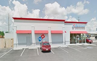
1960s Texaco Gas Station - Now Domino's
SW corner of Route 66 and W 1st St. It was a Texaco gas station (1960-70) with its shingle Mansard-like roof and a stone veneer exterior finish.
It has been reformed, the canopy has gone, but it maintained the original structure, but is no longer recognizeable as a gas station!. The three garage bays are visible, but walled in. The mansard roof has gone, but the corner office is still there, modernized.
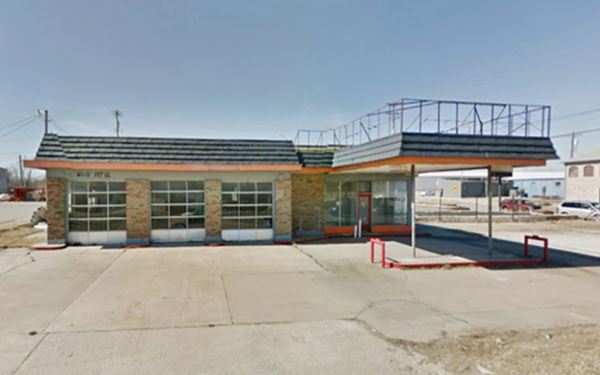
Head west again and to your left is a clasic Motel, all that remains because the old "Elms Motel" was torn down (2016 view while it was there, and now, 2021 a Coffee shop).
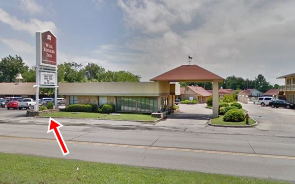
Will Rogers Motel
940 S Lynn Riggs Blvd
It has changed considerably over the years but its layout can be made out in the "then and now" images below.
You can Book a Room in the Will Rogers Inn
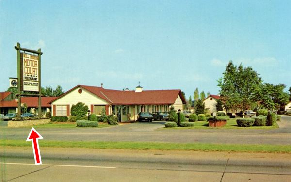
The red arrow in both images shows the original neon sign, same base, same steel posts. The office and canopy have been updated but the overall layout is the same.
This is the end of your Claremore Route 66 City Tour.
Tours & Itineraries
Some sights and landmarks near the town: Now you do some "Will Rogers" sightseeing.
Will Rogers Birthplace Ranch
9501 E. 380 Rd., Oologah. The Ranch is 15.2 miles north of Claremore, visit "Claremore Mound" on the way. Map with directions.
The journey will take you past the dam on Verdigris River, the ranch is beside the lake.
The house was built by Clem Rogers in 1875 with a typical Greek Revival style typical of the South of the USA, it was known as "The White House on the Verdigris". He moved out when his wife Mary died in 1890.
It had clapboard siding and a structure of 10-inch logs. The first floor measures 48 by 32 feet. The bedrooms are on the second floor, above the main rooms, foyer, kitchen, dining room, and spare bedroom.
The house, at Rogers family Dog Iron Ranch had to be moved 3⁄4 of a mile (1.2 km) when the basin was dammed and flooded forming Oologah Lake. It now sits on the shores of the lake.
Claremore Mound
Osage Heritage Site
A sacred spot for the Osage people. It was the site of a bloody confrontation between Native Americans. It is a manmade mound, the work of local Caddoan Mississippian people around 900 AD, Its top covers 25 acres. This low hill (alt. 784 ft - 239 m) is located north of Claremore, on the south bank of the Verdigris River.

1930s postcard Claremore Mound

Claremore mound, an Osage Heritage Site, credits
Oklahoma Historic Marker "Claremore Mound"
There is a Historic Marker on OK-88 (see the map with directions and this street view). The marker reads:
Site of battle of "Strawberry Moon" 1817, when Chief Clermont's Osage village was wiped out by Cherokees. This Osage band from Missouri had settled near the mound at insistence of fur traders of St. Louis. Osages became the wealthiest Indians in Oklahoma by discovery of oil 100 yrs. later on reservation 2 miles west of mound. Oklahoma Historical Society 1995
Natural Attractions
National & State Parks
Oologah Lake
Lake Oologah is a reservoir on the Verdigris River which covers 29,000 acres (120 km2) and has 209 miles (336 km) of shore length.
The U.S. Army Corps of Engineers built the dam in the early 1950s, as part of a flood control program. They still administer it. The dam is an earth-fill embankment 137 ft. (42 m) above the river bed and 4,000 ft. (1.219 m) long. The reservoir provides drinking water for Tulsa.
There are a swimming beach, marina, campground and RV park as well as several public use and picnic areas around the lake. Visit its website for full details.
Some sponsored content
> > Book your Hotel in Claremore


Credits
Banner image: Hackberry General Store, Hackberry, Arizona by Perla Eichenblat
Jack DeVere Rittenhouse, (1946). A Guide Book to Highway 66.
www.visitclaremore.org
Oklahoma Historical Society Route 66 Mobile Tour Stop List.
Route 66 Map in Foyil. Oklahoma D.O.T.
Final Survey Report for the Oklahoma Route 66 Historic Resources www.okhistory.org


