
"Hub City of the Southwest"
Neon sign of Glancy Motel, Clinton, Oklahoma

Index to this page

TheRoute-66.com is reader-supported. When you buy through links on our site, we may earn an affiliate commission at no additional cost to you.
About Clinton, Oklahoma
Facts, Trivia and useful information
Elevation: 1,565 ft (477 m) . Population: 9,033 (2010). Time zone: Central (CST): UTC minus 6 hours. Summer (DST) CDT (UTC-5).
Clinton is located in south central area of Custer County in western Oklahoma. It also spreads into Washita Co., to the south. Its motto is "Hub City of Western Oklahoma".
Although Oklahoma has been occupied for more than 10,000 years, the Indian tribes that lived here just before the land was settled by European Americans was the outcome of the U.S. government's policy regarding Native Americans.
Starting in the 1820s, the government gave Indians new lands in exchange for their former territories in the East. The policy was to remove them west, so it created the Indian Territory west of Kansas and established reservations there.
But the demand for land led to a change in policy. The Dawes Act of 1887 laid down that the natives had to be assimilated. So in 1891 the reservations were dissolved: and the individual tribe members were given a 160-acre plot each. The surplus tribal land was then purchased by the U.S. government for future settlement.
Cheyennes & Arapahos
The Cheyenne had originally lived near the Great Lakes in Minnesota and moved towards the Great Plains in the 1700s. The Arapaho lived in Montana, Wyoming, South Dakota and Canada. Both nations met in the plains and formed an alliance whose territory ranged from Texas to Montana. Despite signing a treaty with the U.S. government (1868) which guaranteed the integrity of their traditional lands, European settlers intruded on their territory. This caused conflict. A second treaty was signed (1867) promising the Arapaho a Reservation in Kansas, but they opted to move with the Cheyenne to a reservation in Oklahoma.
Cheyenne Arapaho Opening
3.5 million acres of land were opened for settlement by the U.S. government on April 19, 1892. The settlers rushed to the Oklahoma Territory for their homestead in the former Arapaho-Cheyenne Reservation.
By the end of the "opening", almost 80% of the land remained unclaimed, and by 1892 only 7,600 people had settled there.
The town is located on the Washita River, It began as a railway junction named "Washita Junction", four miles south of the County seat, Arapaho, where the north to south "Frisco" railroad crossed the east to west running Rock Island Railway.
The townsite was platted in 1899. Sale began in June 1903 by Washita Townsite Co. on land owned by Native Cheyenne. They were authorized by the U.S. Congress to sell part of their land to the townsite company.
Although the area had been opened in the 1892 Cheyenne-Arapaho Land Run, the land had remained in the hands of the natives after it was sold to the individual tribe members prior to the Run.
Arapaho residents feared competition from a strategically located town so they took the issue to court and lost. The Judge Clinton Irwin ruled in favor of the townsite company.
The name: Clinton
Clinton was the name of the judge (Clinton Irving) that defeated the lawsuit filed by the town of Arapaho against the new town wich would become Clinton. That is how Washita Junction became Clinton.
A post office opened in 1903 and the town grew based on farming (cotton and corn). It still is a farming and ranching town. Route 66 passed through it when it was created in 1926, and only in 1971 was it bypassed by I-40.
Clinton is known for its high school football team, the "Red Tornadoes", who have won 16 state championships.
Where to Stay
Book your hotel in Clinton
> > Book your Hotels in Clinton.
Lodging Near Clinton along Route 66
Heading West....
- 27 mi. Elk City
- 82 mi. Hotels in Shamrock, Texas
- 39 mi. Shamrock
- 175 mi. Amarillo
- 212 mi. Vega
Heading East....
- 16 mi. Weatherford
- 60 mi. El Reno
- 74 mi. Yukon
- 89 mi. Oklahoma City
- 100 mi. Edmond
Book your hotel in Clinton
Booking.com>> There are RV campgrounds in Clinton.
Clinton’s Weather


Location of Clinton on Route 66
Winter average low is (Jan) 25°F (-4°C) and the average high is 50°F (10°C). The summer (Jul) average low is 69°F (21°C) and the average high is 95°F (35°C).
Rainfall is 26.5 in. (673 mm) per year and the rainiest month are May (5.1 inches - 130 mm) and June (3.5 mm - 89 mm). There are some 52 Rainy days every year and the relative humidity is around 61%. Some 10 inches (25.4 cm) of snow fall every year from October to March, most of it during Jan. and Feb. (over 2 in. - 5 cm each).
Tornado risk
Clinton is located in Oklahoma's "Tornado Alley and experiences about 12 Tornado watches every year. Tornado Risk: read more about Tornado Risk along Route66.
Map of Route 66 in Clinton, OK
Check out Clinton on our Route 66 Map of Oklahoma, with the complete alignment and all the towns along it.

US 66 Alignments in Clinton
Click image to enlarge
Click on the thumbnail image to see the different alignments of Route 66 through Clinton.
The blue arrows show the 1926 to 1956 alignment. There were many alignments through the city over the course of the years.
The first one (1926) followed Gary, 4th St, Frisco and then south along 10th St. Later it avoided the downtown by taking 4th, Opal St. and 10th. In 1935 it followed Gary and then 10th.
After 1941 and until 1959 it took two separate alignments. They can be seen in the 1957 USGS map. Notice how at that time Gary Blvd. didn't curve around the western side of the city.
1. White arrows. Eastbound traffic, along 4th St. and Opal St. (map)
2. Yellow arrows. Westbound traffic, along 10th St. (map)
Then, in 1959, a four lane freeway was built east of Clinton and at what is now I-40's exit 69, it linked with the old alignment into Clinton. At the same time, Gary Blvd. was extended parallel to the railroad along western Clinton to what is now exit 65 (red arrows). Here it continued west as a four-lane freeway (I-40). See map.
The freeway continued east to Exit 65A, linking with the 10th St. alignment. The current I-40 that loops around the SE side of Clinton didn't open until 1970. Route 66 was decertified in 1985.
Below are some older alignments. Like this map published in 1931. It shows the alignment of US66 between Clinton Oklahoma and Texas. Only a part of the alignment was paved (solid red line), the rest was an "All-weather road" west of Erick, unpaved.

An earlier map, from 1924 -two years before Route 66 was created, shows the alignment of Route 66 through Clinton

Our Map of Route 66 Map in Oklahoma shows all of the US-66 alignments in the state, and all the towns along it.
Route 66 Alignment near Clinton
Read about all the USS 66 alignments close to Clinton, with maps, itineraries and detailed description 1926 to 1985 alignments.
- Clinton to Texola (next)
- Yukon to Clinton (previous)
Route 66 landmarks & attractions
Sights in Clinton
We will start our City tour on the eastern side of town, 1.6 mi. west of Exit 69 along Gary Blvd. Here US66 describes an arch, following a curve in the railroad. At the western tip of the curve you will come across two classic sights.
Mohawk Lodge Indian Store
To your left, at 22702 U.S. Rte 66. The store opened in 1893 in nearby Colony, and in the 1940s relocated to Route 66. It was the first trading post in what is now Oklahoma, in those days "Indian Territory". It is still open, and you can buy genuine Native American handicrafts.

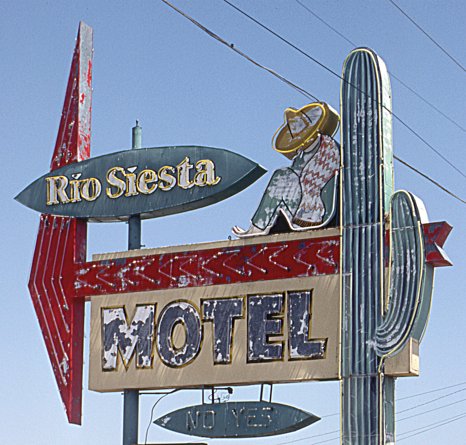
Old Rio Siesta Motel

Rio Siesta Neon Sign, credits,
No longer open as a motel, it opened in 1955 as the "Rio Courts" with its cozy gabled roof units is still standing at the eastern tip of Clinton. By the early 1960s it became the "Rio Siesta Motel", and its great neon sign was erected.
The Freeway wiped out business and the motel closed. A storm in 2007 threw the sign down. But it was saved by the Billboard Museum Association and is being restored, together with many other dozens of neon signs and billboards in a warehouse for the future Billboard Museum.
Below is what it looked like 30 years ago, while the sign was still there (click image to see the video).
Rio Siesta Motel still from a 1990s video Clinton, Oklahoma

Rio Siesta today Clinton, Oklahoma

Pete's Truck Stop (razed)
To the west of the Siesta Motel stood until recently the Apco station, Pete's Truck Stop and Cafe, a Veterans of Foreign Wars post. The building was torn down. Below is a then and now sequence.

Pete's Truck Stop in the 50s. Credits

Pete's Stop before it was razed. Click for St. View
66 Salvage
Facing Pete's is an old gas station, quite altered -it includes a Quonset hut- that has a great vintage gas station sign (the round shape suggests a Shamrock oil station).
66 Salvage old gas station Clinton

Drive west along Route 66, and as you approach the bridge (red arrows in map below) you can make out the original concrete roadbed to your right, on the north side of the highway. The old alignment crossed the Washita River just north of the current bridge. The original 1926 one was a narrow 2-span Pratt Through Truss steel bridge. It was replaced in 1953 by the present one.

As you cross the modern Louis Tittle Bridge and enter Clinton proper, on the fourth block, to your right is the classic "Glancy Motel".
Glancy Motel
217 W Gary Blvd, Clinton
It opened back in 1939 and was owned by Mr. Chester and his wife, Gladys Clancy, their postcard read "We want you to spend a night in these beautiful modern air conditioned courts... on 66 short cut" (short cut was the US 66 alignment that circled round the town instead of going through it).
The motel got its neon sign in 1948 and was revamped with a 1960s space age look as you can see in the "then and now" sequence below. It has preserved its magnificent neon sign.


Site of Pop Hicks
To the west, adjacent to the motel stood Pop Hicks Restaurant; it opened in 1936 and burned to the ground in 1999. You can still see the floor tiles of the old restaurant.
Two old Gas stations

Eason Oil Co. station before it was razed. Click for St. View
Across the street from Pop Hicks and Glancy Motel, to your left, is a 1960s gas station (Street View) with a slanted roof office, two-bay garage
One block west is 4th St. which was part of Route 66 in Clinton. To your right, on the NE corner of Gary and 4th stood Eason Oil Company Gas Station, now torn down and replaced with a statue on a small green plaza (View of statue).
Downtown Clinton
Turning left along 4th Street you can park and stroll around the downtown area of Clinton. Route 66 ran along 4th and turned right along Frisco from 1926 to the early 1930s(?)

Below are some "Then and Now" views of Cinton looking along Frisco Ave.


As you can see, the area is mostly intact (CR Anthony and Co, on the corner, is still standing, but without its neon sign).
Turning around and looking east along Frisco the view has changed (see below) the Calmez Hotel (black arrow upper image) was torn down in 2000 and the Frisco Conference Center built on the site, and also Frisco, at 4th St. (black arrow in bottom image).
However the ghost sign (red arrows) of "Medford Furniture Co." has survived the wear and tear of time.
1930s postcard looking East along Frisco Ave. from 5th St. Clinton, Oklahoma

Looking West along Frisco Ave. from 5th St. Clinton, Oklahoma

Redland Theater
Walk west one block (600 Frisco) to see the former Redland Theater (from 1920 until 1957 it was the Rialto Theater). Its facade and neon sign have been restored and are in excellent shape. The place is now a shop.

Redland Theater ca.1955.

Redland Theater nowadays. Click for St. View
More Route 66 sights in Clinton
Head back to W Gary Blvd. and 4th St., and drive west. There aren't many survivors from Route 66's golden days. We will show you the few that have survived.
On the NW corner of 6th St. is a 1960s (?) oblong box gas station with two bays and glazed office and shingles on a mansard roof. It has two separate flat canopies over the pumps and a tall steel column on the corner that held its sign. Pictured below.

1960s station in Clinton. Click for St. View
 in Clinton OK")
Texaco (?) Clinton. Click for St. View
On the next corner is another gas station pictured above, with two garage bays an oblong box layout, flat canopy. It sign with three vertical steel poles seems like those used by Texaco.
Travel Inn
Head west, and after crossing 10th St. is the old Travel Inn motel (1015 W Gary). It used to be the "Travelodge", and had a swimming pool facing Route 66. The two floor U-shaped building is still open as a motel.


Former Gas Station
Another former Service Station on 13th and W Gary, now it is Clinton Tag Agency. The building has multiple glazed windows on garage door and office, flat canopy, a 1960s design.
It is pictured below.

Vintage gas station Clinton. Click for St. View

Ancient gas station sign post. Click for St. View
Service Station sign
Just west of Mr. Zippy's Ice and Water, on the right (eastern) side of the highway, right on the currve at S 16th and Gary Blvd.
You will see the small stall and next to it the rusting sign post with a steel pole and a circular support that at one time held the sign. It is pictured above.
Oklahoma Route 66 Museum
Head south along the westbound lanes for 0.7 mi. to visit this classic museum, a must-see-sight in Clinton.
2229 Gary Boulevard, Clinton OK.
It is the first official state-operated Route 66 museum in the country. A complete exhibition on Route 66, a trip through time with iconic images, vintage artifacts and bygone days.
Full details: (580) 323-7866 and their website.

1950s Valentine Diner, Clinton. Click for St. View
Valentine Diner
There is a "Valentine" (the brand) diner, the "Route 66 Diner" at the Oklahoma Route 66 Museum.
It was originally located on Route 66 in Shamrock, Texas, where it was the Porter House Cafe. It opened back in 1956 and was run by the Porters. It closed for good in 1964 and was bought by the Museum and restored in 2002.
This diner was one of more tan 2,000 diners built by the Valentine Manufacturing Company of Wichita, Kansas. They were invented by Arthur Valentine (1891 - 1954) who started making them in 1947. They came in different sizes and models, and were portable; easy to move and ready to use.

Trade Winds Motor Hotel
This late 1950s motel is across Route 66, from the museum. Its postcard tells us it is on "2120 Gary Freeway... New Luxurious Motor Hotel with 61 modern units - Suites with sundeck Patios... Private Club"
Still open and operating as a motel. With the same four steel poles holding up a modernized neon sign. The pool area (red arrow) is now hidden behind a building.
Elvis Presley once stayed at the Trade Winds Courtyard Inn.


Drive east along (see map) along Jaycee Ln. to 10th St., turn left along it and then right along Opal St. This is the eastbound Route 66 alignment through Clinton. There are some US66 sights along it.
Western Motel
At Opal and 8th St., to your right, the former motel now has a Chinese Restaurant next to the old offices. Its postcard tells us that it was "Clkinton's finest. New, quiet, and Comfortable... Garage, tubs and showers, swings and slides" (family hotel) managed by Mr. and Mrs. Clyde Rush. Another postcard tells us it was operated by "Mr. & Mrs. D. D. Adams, Managing owners". Below is its Then and Now photos. Its yellow neon sign has gone. Red arrows show the same buildings then and now.


Across the street from the motel, to your left, you will see an old building, maybe a shop or even a gas station (no sign of pumps though), it has a rusty signpost next to it. Pictured below.

Old closed shop. click image for Street view

Old gas station -gone. Clinton, click image for Street view
Head east, where Opal Ave. and S 4th St. meet there was a 1970s station, only its sign survives. It was built where two main highways met, US 66 on Opal Ave. and US 183 along South 4th Ave. Image above -before it was torn down.
Go north along S 4th St. for one block, and turn left along Modelle Ave. leaving Route 66. Head west at 10th St. you will meet the westbound Route 66 leaving Clinton, on the SE corner is an old Sinclair gas station.

Old Sinclair station. Click image for Street view
Sinclair Station
603 S 10th St. with a V-shaped separate canopy, two-bay garage and an office. Maybe from the 1950s.
Now it is an auto repair shop. Head south and visit the historic Park.
Historic McLain Rogers Park
The park sits on Route 66 at the intersection of S. 10th St. and Bess Rogers Dr.
Listed in the National Register of Historic Places
The Federal goverment's Works Progress Administration (WPA) employed the jobless workers of Clinton in several emergency projects. One of them was the McLain Rogers Park, named after Clinton's mayor, built between 1934 and 1937.

It was a 12 acre park with an Art Deco acces gate on Bess Rogers Drive. It had tennis courts, baseball field, picnic facilities and a bathouse. A highway patrol building was added in 1941 to police the traffic along Route 66.
Continue westbound heading south along the curving S 10th St., after 0.3 mi. at Adams St., you will see two US 66 attractions to your right.
Marshall Cafe
The Cafe was built in front of the "Home on the Range Motel", it offered steak and chicken meals. Now it has a Mexican or Spanish style, quite opposite to the modern look it had in the 1950s.


Former Home on the Range
The motel is behind Marshall Cafe, at 1116 S 10th St. It is stil operating as a motel, though now it is called the "Relax Inn".
It had twenty units, and it stated that it was "well back from the highway" so it was less noisy. Below is a Then and Now sequence.


Head south, along US Hwy. 183, Neptune Dr. (it overlaps with US66 here), pass the freeway and drive 1.4 mi (Map) to the point where US 66 split to the west and US 183 headed south. To your righ on the "Y" fork is a historic gas station.
Y Service Station
Listed in the National Register of Historic Places
1733 Neptune Drive. A Vintage 1930's Route 66 Service Station and Cafe at a key location in Clinton.It was built in 1937 on a strategically located corner south of town; a "Y" shaped intersection that gave it its name. It had pumps serving both routes.
Later it included the "Y Modern Cabins", now demolished. The Federal WPA projects during the Great Depression upgraded the neighborhood with Neptune Park.
It was built in Southwestern Mission Revival style with stucco finish and simulated red roof tiles. It also incorporated some Art Moderne streamlining.
As traffic grew, so did congestion and Route 66 was realigned in 1956 bypassing Y Service Station. It has evoled and now is an automobile dealership.

West along the 1926 - 56 Route 66
The road continued west from the Y Service Station after the curve along W. Commerce Rd. on the north side of Neptune Park.
This segment was paved in concrete in 1931. Ahead, 0.9 mi. past the gas station (Map), it passes under the railroad in an underpass built in 1931. This is the original railroad tressle.
See it's Street View, a narrow and dangerous highway.
Ahead the old highway meets I-40 at Exit 62, heading west along the current South Frontage road of I-40 till N 2180 Rd. where now I-40 cuts the old alignment which curved to the north and now continues as North Frontage Road into Foss.
Some sponsored content
> > Book your Hotel in Clinton
Credits
Banner image: Hackberry General Store, Hackberry, Arizona by Perla Eichenblat
Jack DeVere Rittenhouse, (1946). A Guide Book to Highway 66.
Dee Ann Ray, Clinton. Encyclopedia of Oklahoma History and Culture, www.okhistory.org
Y Service Station National Park Service Route 66 Corridor Preservation Program
Jim Ross, 2015. Historic U.S. 66 Bridge Database 1926-1985