Route 66 in Continental Divide NM
Index to this page
- About Continental Divide
- Weather
- Hotels
- Map of US 66 through Continental Divide
- What to see and do on the Divide

TheRoute-66.com is reader-supported. When you buy through links on our site, we may earn an affiliate commission at no additional cost to you.
About Continental Divide, New Mexico
Facts, Trivia and useful information
Elevation: 7,250 ft (2.200 m). Population: n⁄a (2020).
Time zone: Mountain (MST): UTC minus 7 hours. Summer (DST) MDT (UTC-6).
Continental Divide is a tiny village with a few scattered houses, gas station and post office located in McKinley County, New Mexico on Route 66.
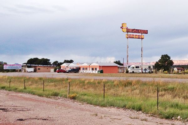
Old Whiting Brothers Motel and Service Station Sign on Route 66, Continental Divide New Mexico
Read More below. A. Whittall
The hills and valleys at Continental Divide have been inhabited for almost 11,000 years. During the last millennia Native Americans of the Diné (Navajo) group have lived in the mountains to the north and south of it.
The Navajo were farmers that used the rivers to irrigate their crops of maize and squash.
The Spanish were the first Europeans to reach this region in 1540, when the expedition commanded by Francisco Vásquez de Coronado occupied Zuñi Pueblo and explored New Mexico and rode east, all the way to the Great Plains.
Although the Spaniards returned in 1597 to occupy and settle "Nueva Méjico", they never occupied the area where Continental Divide is now located. Their outposts were the Pueblos of Zuni, Laguna (on Route 66) and Acoma to the south and east, at a safe distance from the raids of the Navajo warriors.
This situation remained unchanged through the period of Mexican domination (1821 to 1848). But when Mexico ceded the territory to the U.S.A. after losing the Mexican - American War in 1848, the American Army explored the region and, between 1862 and 1864, pacified the region by subduing the Navajo.
The nearby Old Fort Wingate south of Grants and the later Fort Wingate just west of the Continental Divide, imposed peace (though at a terrible cost for the Navajo people).
In 1881, the Atlantic and Pacific Railroad (later acquired by the Atchison Topeka and Santa Fe Railway) decided to build its line through "Campbell Pass", across the Continental Divide. They built a stop on the spot which received different names as time went by:
In 1884 it was known as "Continental Divide", in 1895 it was named "Summit", but after that date, as from 1910 until 1936, it was "Gonzales". It reverted later to its current name, which is a good description of its geographic context.
In 1914 the New Mexico State Highway #6 was built through Campbell Pass, as part of the National Old Trails Highway system. In 1926 Route 66 was aligned along the state highway. It remaind so until replaced by I-40 in the late 1960s.

The weather in Continental Divide
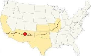
Location of Continental Divide on Route 66
Continental Divide has dry and sunny weather. Its altitude and arid climate mean that summers are warm but not too hot, on the other hand winters are cold; there is a large variation between day and night temperatures so nights are cool in summer and very cold during winter.
The average high in summer (July) is about 87°C (30°C), and the average low is 53°C (12°C). The average high in winter (Jan) is around 46°C (8°C), while the avg. low is only 14°C, well below freezing point (-10°C). Only 10.5 inches of rain falls each year (266 mm), most of it during the Summer Monsoon: July, August, September and October with 5.6 inches (143 mm).
About 30 in. of snow fall during winter (75 cm) and snowstorms may take place too. Expect strong cold winds during Spring.
Tornado risk
There is no tornado risk in Continental Divide: McKinley County has no Tornado watches. Route 66 west of this point, and all the way to California has no tornado events at all.
Tornado Risk: read more about Tornado Risk along Route66.
Getting to Continental Divide
To the west is the city of Gallup (27 mi.) followed by the Arizona state line (50 miles). Heading east is Grants (36 mi.) and even further east, across the Rio Grande is the City of Albuquerque is 114 mi.
Heading north of Albuquerque along the 1926 to 1937 alignment of Route 66 known as the Santa Fe Loop is New Mexico's state capital, Santa Fe (173 mi.).
Where to Stay: Hotels
There aren't any hotels at Continental Divide, but there is lodging very close to it along Route 66.
> > Book your Hotels in neighboring Grants or Gallup
More Lodging Near Continental Divide along Route 66
Below you will find a list some of the towns along Route 66 east and west of Continental Divide; click on any of the links to find your hotel in these towns.
Heading West in NM and AZ
- 27 mi. Gallup
- 75 mi. Chambers
- 123 mi. Holbrook
- 155 mi. Winslow
- 194 mi. Twin Arrows
- 218 mi. Flagstaff
- 251 mi. Williams
- 293 mi. Seligman
- 329 mi. Peach Springs
- 365 mi. Kingman
Heading East
- 37 mi. Grants
- 58 mi. Acoma Pueblo
- 117 mi. Albuquerque
- 155 mi. Moriarty
- 227 mi. Santa Rosa
- 289 mi. Tucumcari
- 369 mi. Vega, TX
- 407 mi. Amarillo, TX
The Santa Fe Route 66 segment
- 173 mi. Santa Fe
- 232 mi. Las Vegas NM
Book your hotel in neighboring Gallup
Booking.com>> There is an RV campground at Lake Bluewater and another in Grants
Map of Route 66 through Continental Divide
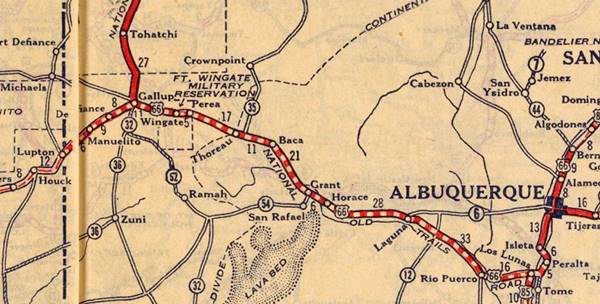
Thoreau to Continental Divide
The 1930s-60s alignment runs along the Frontage Road all the way to Continental Divide it has a minor alteration at the freeway's exit there, and it ends in a Dead End on the western side of that community. This is the 1930-60s alignment Thoreau-Continental Divide map
The Older Alignment, a "trace"
Stephan Joppich marks it with an uncertain course from Thoreau to Coolidge along the north side of the railroad. We mark its approximate alignment in our custom map with a pale violet line. You can see two culverts along the trail: our map shows them: culvert 1 and culvert 2.
Westwards from Continental Divide
Coolidge
The 1930s-60s course of Route 66 is interrupted at Continental Divide and it ran parallel to what is now I-40, on its northern side as you can see in our custom map where we marked it with a green line. This 1961 aerial photo taken at Coolidge shows the new freeway and Old '66.
There is a section that can be driven at Coolidge (map) but it is altered by Exit 44's ramps; from there to Perea the old road is buried under the freeway (yellow line) and resurfaces at Exit 36 to enter Perea.
Old NM-6 and 1926-30 Route 66 from Coolidge to Perea
This is a road with some remaining culverts, a mostly and some segments still in use. The 1920s-30s map gives a rough idea of its alignment. But it isn't 100% accurate. Our custom map marks the spot of an old bridge on this alignment near Staples.
Route 66 Alignment near Continental Divide
With maps and full information of the old roadway.
- Lupton to Winslow (next)
- Albuquerque to Lupton (Continental Divide's)
- Santa Rosa to Albuquerque (previous)
Continental Divide: its Attractions
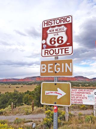
Route 66 "Begin" sign at Continental Divide
A. Whittall
The Great Continental Divide
What is the Continental Divide?
Let's brush up on our knowledge of geographic terms:
- A drainage divide (or water divide, divide, ridgeline, watershed or water parting) is an imaginary line that separates two neighbouring drainage basins.
- A drainage basin (or a catchment) is an area of land that drains all the streams and rainfall to a common outlet.
The Continental Divide also known as "The Continental Divide of the Americas", "Continental Gulf of Division" or the "Great Divide" is a special kind of "Drainage Divide", in which the outlet of the "drainage basins" it divides, are oceans. Therefore, the Continental Divide, is a watershed: from the divide, the waters can flow east into the Atlantic Ocean or west into the Pacific Ocean.
It is shown in Blue in the map below. Route 66 (in red) crosses it at Continental Divide NM.
The Great Divides in the U.S.

Since water flows downhill, the "drainage divide" is usually located on a high area: a mountain range or the ridge of a line of hills.
In the case of the Great Divide, it runs along the main ranges of the Rocky Mountains, and further south, in South America, along the Andes, all the way from Alaska to Tierra del Fuego.
So the "Divide" begins in Alaska, at the Cape Prince of Wales on the Bering Strait in Alaska and extends across North America. In this northern part, it separates the Arctic Ocean basin from the Pacific Ocean basin. Then, further south the Divide marks the split between the Atlantic and the Pacific Oceans.
There are also some Endorheic basins. These are closed drainage basins which retain water and have no outflow to any ocean in the USA, Mexico and in South America. You can see one of them in the map above: the Great Basin Divide in California, Nevada, Utah, Oregon and Idaho (in brown).
The map also shows the divide into Hudson Bay (green), and the one that drains the Great Lakes through St. Lawrence river (violet).
The Continental Divide Trail
For those who like to hike, the Continental Divide Trail is a path that follows the Divide across the US between Mexico and Canada. It continues north in Canada as the Great Divide Trail all the way to Kakwa Lake in British Columbia.
Visit their website: www.continentaldividetrail.org
America's Fascination with the Continental Divide
During the period of British domination, King George III issued "The Royal Proclamation of 1763" which laid down the boundary between the existing colonies to the east of the Appalachian Mountains and the new territory that it had wrested from France after the Seven Years' War. The border would follow the "Eastern Continental Divide" which separated waters running west towards the Mississippi River and east towards the Atlantic Ocean. In the north it followed the "St. Lawrence Divide", along the drainage of the Saint Lawrence River to the north.
The idea was to keep the colonists enclosed in the east as it forbade settlement west of the border. This of course was resisted by the Americans, and shortly after, in 1776 they became independent and built a great new nation, the United States of America.
But "divides" would accompany the fledgling nation as it redefined its borders.
After acquiring the remaining French territories west of the Mississippi River in 1803 (the Louisiana Purchase), the U.S.A. and Britain shared a border which was again defined by "Divides".
They had agreed that the watershed between the Hudson Bay to the north and the Mississippi and Missouri Rivers to the south would mark the border between Canada and the U.S. To the west, beyond the "Continental Divide", and all the way to the Pacific Ocean
lay a vast and yet unclaimed land between Russian Alaska and Spanish California.
Lewis and Clark
President Thomas Jefferson commissioned an expedition, "The Lewis and Clark Expedition" (or Corps of Discovery Expedition) commanded by Cap.Meriwether Lewis and his friend Second Lieutenant William Clark. Their objective was simple; to explore and map the territory of Louisiana and, even more important, find a route across the Continental Divide and establish an American presence to the west of it before any other power claimed that territory.
They were in fact the first American expedition to cross the continental divide and reach the Pacific coast. And, on August 12, 1805, Lewis wrote in his diary:
The road took us to the most distant fountain of the waters of the Mighty Missouri in surch (sic) of which we have spent so many toilsome days and wristless (sic) nights. thus far I had accomplished one of those great objects on which my mind has been unalterably fixed for many years, judge then of the pleasure I felt in all[a]ying my thirst with this pure and ice-cold water. here I halted a few minutes and rested myself. two miles below McNeal had exultingly stood with a foot on each side of this rivulet and thanked his god that he had lived to bestride the mighty & heretofore deemed endless Missouri. after refreshing ourselves we proceeded on to the top of the dividing ridge from which I discovered immence ranges of high mountains still to the West of us with their tops partially covered with snow . . . here I first tasted the water of the great Columbia river...
Meriwether Lewis
They left the territory of the U.S., and entered land that belonged to the Natives.
As America's confidence and power grew, President James K. Polk, wanted a bicoastal America, and that meant incorporating Oregon into the U.S. So he reached a peaceful agreement with Britain: the 49th parallel would mark the boundary between Canada and the U.S., each side ceded some land and the Divide became, at least north of Mexico, a part of the U.S.A.
America then focused towards the Southwest, the Mexican-American War of 1846-1848 and pushed Mexico south of the Rio Grande, incorporating California, Nevada, Arizona, Texas and parts of Colorado, and, the whole of New Mexico, where Campbell Pass crosses the Continental Divide.

The Continental Divide on Route 66
The Continental Divide is a broad valley with an east to west direction known as "Campbell's Pass". The Atlantic & Pacific Railroad (later the Atchison Topeka and Santa Fe Railway) chose this route for their tracks because it had a very moderate grade (21 feet per mile or 0.4%). There were no mighty summits here no mountain tops to cross, only a low lying wide pass.
The railway built a station (Gonzales) close to the summit of the pass, at an altitude of 7,250 feet (2.211 m).
Campbell Pass
The pass has an elevation of 7,270 ft. (2.216 m) and is crossed by the Interstate 40, old Route 66 and the BNSF Railway (which in the past had been the AT & SF Railway).
It is a pass in the Rocky Mountains and marks the continental divide in this point of western-central New Mexico.
The pass is not a sharp valley between towering peaks, instead it is a wide and easily accessible pass between low altitude mountains.
The origin of its name "Campbell" is unknown, and may be connected to the railroad.
The divide is enclosed on the south by the Zuni Mountains and to the north by the high sandstone cliffs that mark the southern end of the Colorado Plateau, with Powell Mountain very close to the divide.
The water falling on the eastern flank of the divide will run east and empty into the Rio San Jose River and via the Rio Puerco reach the Rio Grande, and the Gulf of Mexico on the Atlantic.
The water falling on the western slope will run west along the Rio Puerco (of the west), and then the Little Colorado River to the Colorado River and along it until it empties in the Pacific Ocean.
The other Divides on Route 66
Shortly after leaving Chicago, Route 66 crossed the "St. Lawrence Divide", at the Chicago Portage National Historic Site, in Lyons IL.
And it enters the Great Basin Divide between Needles, and Goffs in California, leaving it at Cajon Pass.
Route 66 Attractions at the Great Divide
As the road climbs towards the pass, towards the north you will see the red sandstone escarpments of the southern terminus of the Colorado Plateau, to the south the Zuni Mountains.
The vegetation changes from the scant grass, tumbleweed and shrubs commmon in the high desert to one with some trees, such as pinyon pines and junipers close to the Pass.
As you approach Continental Divide along Route 66 (it is the northern Frontage Rd. of I-40 you will see billboards announcing the "Indian Village".
Shops, Motels and Trading Posts
The Divide was a place where travellers stopped to fill their tanks and bougth mementos. Jack DeVere Rittenhouse in his "A Guide Book to Highway 66" lets us know how it was in 1946: "... are several establishments: The Top O' The World Hotel & Cafe, Great Divide Trading Co., and the Continental Trading Post and grocery..." at that time gas was found 3 miles west, at Fred Wilson's Indian Trading Post.
Great Divide Trading Post was on south side of route 66, and was ran in the late 1940s by Bert Greer. Now demolished.
Distant Drums was on north side of route 66 and opened in the early 1960s, the Gonzalez family ran it until the 1980s.
There are still shops and trading posts at the Divide; just ahead, south of I-40's exit 47 is the Indian Market, a gas station and the Indian Village. To your left, between Route 66 and the freeway is the First Historic Marker.
Official Continental Divide Marker
Landmark Official Marker
The back of the marker shows a map with some local attractions. The front of the marker reads:
Continental Divide
Elevation 7,245 ft.
Rainfall divides at this point. To the west it drains into the Pacific Ocean, to the east, into the Atlantic.
This is its Street View.
It is one of two markers at the pass, the other is on the south side of the freeway.
Ahead is the Top of the World gift shop (to your right), and another marker sign with a mural painted on a wall behind it:
Top of the World, Sign and Mural
The "Divide Sign" Route 66, Continental Divide New Mexico
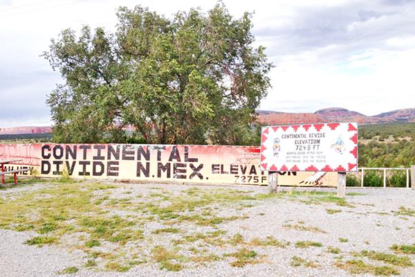
US 66 Begin Sign
Ahead, passing the gift shop, at the overpass on I-40 is the Route 66 Begin Sign that we posted further up.
Cross the freeway to the south side. Here you will see the remains of an old service station, the 2nd Official Marker and a gift shop.
Second Official Marker

Official Marker and old gas station. A. Whittall
The second marker is on the south eastern side of Route 66 and I-40, on the southern Frontage road (Street View).
South of it are the remains of an old gas station, the canopy is still standing over empty pump islands.
Both can be seen in the image (red arrows).
On the north side of the freeway are some more sights.
US 66 Dead End Sign
Return to the "Begin sign". That indicates that Route 66 starts here, if you head east towards Chicago. If you turn west, towards Los Angeles you will see the "Dead End Sign", because there is a dead end just ahead.
Dead End Sign on Route 66, Continental Divide New Mexico
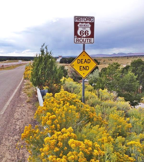
Ignore the "Dead End" sign and head along the North Frontage Road. Just before it ends was the "Top O' The World Motel" (closed), and next to it is the signpost of a now defunct Whiting Brothers Motel and Service Station.
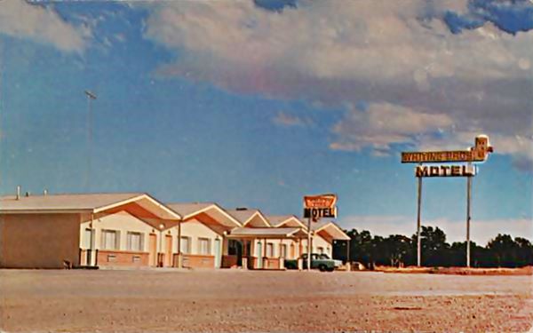
Whiting Brothers Service Station and Motel

Whiting Bros.
1958 Southwest US road map.
Credits
Four Whiting brothers (Arthur, Earnest, Eddie and Ralph) founded the company in 1926 -the same year that Route 66 was created- and saw it grow to over 100 filling stations plus fifteen motels and truck stops from California to Texas. Many of them were located along Route 66 where you can still see the remains of those that were abandoned.
Their slogan was "Most of the Best for the Least".
The company based in Arizona went through difficult times during the Arab Oil Embargo in 1973, which led to fuel shortages and when the Interstate highway system bypassed many of their service stations located on U.S. Highways (like Route 66). The company sold the stations piecemeal.
The motel is there, but has closed; the sign is still there (Street View), and the service station still stands. See its Street View. It has the typical simple flat-roofed building with the canopy covering the two pumps. The Canopy now it reads "interlock installers".
In case you are wondering what an "interlock" is, it is a device like a breathalyzer, installed in a vehicle to deter drinking and driving. To start the vehicle, the driver must deliver a breath sample into the device. In New Mexico it is required for at least one year for all first-time Driving Under the Influence offenders; subsequent offenses require longer periods of installation. Drinking and driving is a problem in NM.
Whiting Bros. and Route 66
> > Read more: Visit our Whiting Bros. and Route 66 webpage.
Learn all about the motels and gas stations of Whiting Bros along US 66 in New Mexico and Arizona.

Below is a vintage postcard of the motel ca. 1960. Same building and sign that can be seen today.
Whiting Bros. Motel today
Continue your Road Trip
This marks the endpoint of your journey in Continental Divide; head west into the next town: Wingate, to continue your Route 66 Road Trip.

Sponsored Content
>> Book your Hotel in Gallup


Credits
Banner image: Hackberry General Store, Hackberry, Arizona by Perla Eichenblat
Jack DeVere Rittenhouse, 1946. A Guide Book to Highway 66.
Guidebook of the Western United States: Part C - The Santa Fe Route, With a Side Trip to Grand Canyon of the Colorado, bulletin 613. Nelson Horatio Darton.
Robert Julyan. 1996, The Place Names of New Mexico, UNM Press.

