Small town on Route 66 in Missouri
Index to this page

TheRoute-66.com is reader-supported. When you buy through links on our site, we may earn an affiliate commission at no additional cost to you.
About Conway Missouri
Facts, Trivia and useful information
Elevation: 1,407 ft (429 m).Population 788 (2010).
Time zone: Central (CST): UTC minus 6 hours. Summer (DST) CDT (UTC-5).
Conway is small town in the southwestern corner of Laclede County, in south central Missouri.
There are Two Conway's on Route 66
This one in Missouri is the eastern one, second one is located in Texas Conway.
History of Conway
Read about the region's history in our Lebanon page (County seat, 15 mi. north of Conway).
The name: Conway
Named after the first store keeper back in the 1870s. It is an Irish surname which was converted from different gaelic names into this English variant "Conway": such as Mac Connbhuidhe (Mac: "son" of Connbhuidhe: "Yellow Hound") or Mac Connmhaigh (son of "Conmhaigh" which meant "Head Smasher").
Laclede County was established in 1849 and was named after Pierre Laclède, the Frenchman who founded St. Louis. The town was platted in 1869 just before the arrival of the South Pacific Railroad. That same year the railroad built its station half a mail away, naming it "New Conway". The two towns merged into one. The post office opened in 1871.
There were canning factories in the area which processed tomatoes. They went out of business in the 1940s.
Route 66 was created in 1926, and passed throught the western part of the town and brought a flow of tourists which were served by the locals. When The highway was aligned to the west and widened into a four lane expressway, Marshfield focused on it and kept on making a living from travellers, as it does today with I-44.

Find your Hotel near Conway MO
Find a hotel near Conway. There are no hotels in this town. However, you can find a room nearby, in neighboring Marshfield.
> > Book your hotel in Marshfield
More accommodation close to Conway along U.S. 66
The towns located on the Mother Road have plenty of hotels; below you will find a list of links with the accommodation in each of these towns.
Hotels West, in Missouri
- 13 mi. Marshfield
- 26 mi. Strafford
- 38 mi. Springfield
- 98 mi. Carthage
- 113 mi. Joplin
- 130 mi. Baxter Springs
- 146 mi. Miami
- 162 mi. Afton
- 177 mi. Vinita
- 214 mi. Claremore
- 224 mi. Catoosa
- 237 mi. Tulsa
Heading East in Missouri, more accommodation
- 14 mi. Lebanon
- 48 mi. Waynesville
- 52 mi. Saint Robert
- 78 mi. Rolla
- 89 mi. Saint James
- 103 mi. Cuba
- 121 mi. Sullivan
- 136 mi. Saint Clair
- 148 mi. Villa Ridge
- 154 mi. Pacific
- 164 mi. Eureka
- 182 mi. St. Louis
>> Check out the RV campgrounds in Marshfield
Weather in Conway
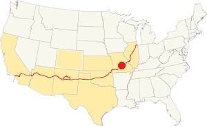
Location of Conway on U.S. Hwy. 66
Conway has clearly defined seasons. Its position on the northern limit of U.S.'s humid subtropical climate gives it very humid weather during late summer.
The July average temperatures (summer) temperatures are: (high) 89°F (31.6°C); (low) 68° (19.8°C). The average January (winter) high temperature is 43°F (6.1°C) while the average low is below freezing: 22°F (-5.3°C).
Annual rainfall averages 45.6 in. (1.160 mm), and Conway receives about 17 in. of snow (43 cm) every year.
Tornado risk
Conway is located in the "Tornado Alley" and Laclede County has around 8 tornado strikes per year.
Tornado Risk:read more about Tornado Risk along Route 66.
Map of Route 66 through Conway, Missouri
Route 66 Map and its alignment
This is a map of US66 in Conway, it will come in handy for your road trip. It shows the 1926-53 alignment.
The original alignment runs with a north to south course from Phillipsburg, across Conway and onwards through Sampson and Niangua to Marshfield.
It was replaced in 1953 by a new alignment further west, which was a four-lane highway; it is now buried beneath I-44.
The alignment in Conway
Visit our pages, with old maps and plenty of information about US 66's alignments.
- Springfield to Joplin (next)
- Rolla to Springfield (Conway's)
- Gray Summit to Rolla (previous)
Route 66 Sights in Conway
Landmarks and Places to See
Historic context, the classic Route 66 in Conway
In 1946, Jack DeVere Rittenhouse published his "A Guide Book to Highway 66" in which he mentions Conway during Route 66's heyday.
Conway. (Pop. 516)... gas; garage; cafe; few cabins. A small business district is off US 66 Rittenhouse (1946)
Rittenhouse also added that there was a gas station and cafe 2 mi. west (surely the Top O' Th' Ozarks).
Thinking about visitingt Branson?
Some tours and sightseeing
Sponsored
Tour the route 66 landmarks in Conway
We will tour Conway from east to west, driving south from Phillipsburg towards Sampson.
Route 66 runs on the eastern side of the freeway, and roughly 2.7 mi. west of Phillipsburg it turns away from I-44 and takes a north-to-south alignment.
Here was a 1950s gas station.
The "Last" Harris Cafe and Texaco station
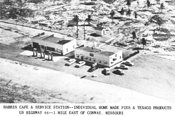
After Route 66 bypassed Conway in the early 1950s, business fell drastically at the original Harris' stations and cabins in Conway's Old Route 66 juntion. So he relocated his business to the new alignment at a new location.
The cafe and Texaco station was located next to the new highway on its eastern side. At that time only two lanes had been built (roughly where the modern westbound lanes are located). Then the second pair, eastbound were added. All of them are now overlaid by the freeway's roadbed. There is a cut here, and Harris' property is on the top of a low hill. It was linked to the original four-lane alignment, but when it was upgraded to modern freeway standards, it became a limited access highway and Harris was cut off and it closed. Two roads connect it to the Old US 66 that runs by the eastern side of the premises.
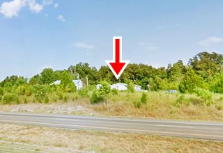
Now it is "John Ikerd Auto Sales" at 13200 U.S. Rte 66. You can see it in a 1955 aerial photo on the left side of the image. This map shows where it is.
Below is a 1950s postcard, The highway is out of view on the bottom. Conway is to the right.
Last Harris Cafe & Texaco
Drive west towards Conway, ahead is the site of the former "Duck Inn Café", to your right, but nothing remains of it (street view.)
Just ahead is the main junction of Route 66 and W. Jefferson Ave. Here were the original Harris gas stations, cabins and cafe.
Harris' stations and cabins
Nothing remains of Harris' complex. On the NW corner, where the post office now stands, was the Standard Service station and the cafe. On the SW corner was the Conoco gas station and Harris Tourist Court (where the First Stat Community Bank is now located). On the other two corners were a Shell filling station and a home.
S.W. "Sim" Harris owned all four corners at this crossroads, his son Barney (with his wife Mary) opened their café here in 1929 next to the Standard station. It was famous for its pies (still promoted in the 1950s in their postcards!) baked by Mary.
Side Trip into Conway
Rittenhouse wrote that the "small business district is off US 66", it is 0.2 miles east, so turn left along W. Jefferson to visit it.
Vintage Gas Station
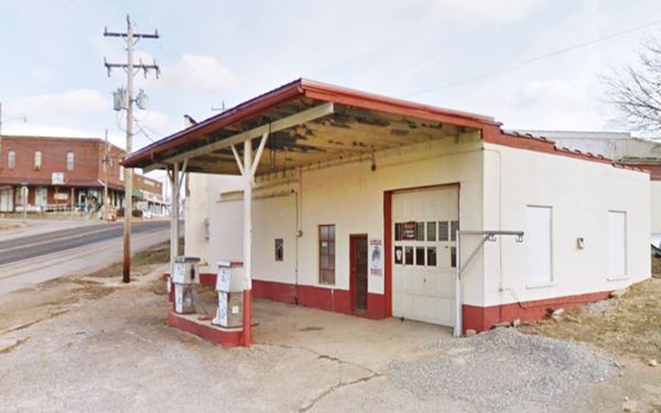
To your right, on the corner of Myrtle and Jefferson St. Conway is an unbranded service station with two old fashioned 1970s pumps, a single-bay garage is on the right side of the office. The flat canopy covers both pumps. A relic! Pictured below.
View of Old Service Station in Conway
Wilkerson Bros. Co.

1927 picture Wilkerson Bros. Conway MO. Credits
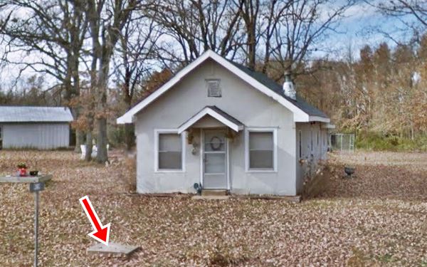
Head uphill towards the railroad, to your left at 105 W Jefferson Ave on the corner with Main St., that runs parallel to the railroad, is a single story red-brick building with white limestone details.
The name engraved on its facade reads "Wilkinson Bros" and appears to be a Ford dealership. Notice the glass brick design and the artistic use of stained glass to display the words "Ford", "Lincoln" and "Fordson."
It opened in 1927 and had two gas pumps on Jefferson -see vintage photo.
Ghost Sign
Turn right at the corner and ahead along S. Main St. is the City Hall building. Notice the "ghost sign" (A ghost sign is an old hand-painted advertisment that has survived on a building for a long time and not been removed or painted over) on the wall, proclaiming "King of them all - Magnetic Soda Water in bottles 5 cents. 'Its in the water". Lebanon", Lebanon was famous for its magnetic water and even had a spa hotel in the 1890s. See its See view.
Attractions on the Freeway (1953 Route 66)
Head back to the Route 66 junction with W. Jefferson, and then continue towards the interstate (0.8 miles west). There are two Route 66 attractions that you can visit along the freeway.
- The Route 66 Memorial (west)
- The Meramec Barn (east)
Route 66 memorial Rest Area
It is a 3.1 mi. drive towards the SW of town along I-44. Take the westbound lanes at Exit 113 and head west, leave the freeway at
the rest area (Map with directions).
The rest stop on both east and westbound lanes is dedicated to historic Route 66
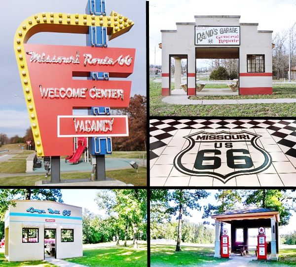
See this street view. The picnic tables are placed in buildings resembling classic Route 66 motels, garages, gas stations, and stores. The sign in front of the main building is a great copy of Lebanon's Munger Moss Motel neon sign.
Now you can visit the "second" landmark on the freeway corridor in Conway.
Meramec Caves Barn Sign
At 12555 Martingale Dr. Conway. To the northeast of Conway. If you start from the Rest Area, it is a 11 mi. drive Map with directions from Rest Area; if you start from Conway's Exit 113 it is much closer: only 1.5 mi, along the west side frontage road (Map with directions).
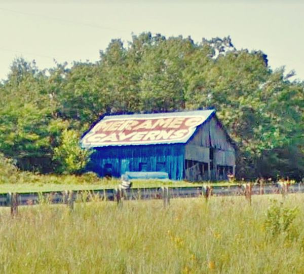
To your left, on the NW side of the highway is a blue barn that has, a painted advertisment on its roof promoting the "Meramec Caverns". It is one of the last remaining in Missouri (see the one in Phillipsburg MO); there is a similar one further the west on Route 66, see Chandler Barn in Oklahoma.
Meramec Caverns
Meramec Caverns were actively promoted by Lester B. Dill, who actually invented the bumper sticker as a means of advertising them. He erected billboards along Route 66, and also the painted barns on a grand scale.
The 4.6 mile-long (7.4 km) cavern system is close to Stanton, Missouri near Route 66. Read all about the Meramec Caverns in our Stanton page.
It began to be promoted to the public as a tourist attraction in 1935 and became one of the main attractions along the old US Highway 66. Today it is visited by over 150,000 tourists every year.
Head back to Conway and at Jefferson and Route 66 (site of the original Harri's stations), turn right and head west towards Sampson. There is one final attraction in Conway just 1.2 miles south of town (Map with directions).
Top O' Th' Ozarks

Top O' Th' Ozarks gas station and Cafe, 1940s, credits
The original Top O' Th' Ozarks gas station and Cafe. As its name hints, it was built on the top of a long grade leading out of Conway. Two brothers, John and Cassie Warren opened it in 1940. It was a Tydol station and a café on the western side of the highway (to your right; see the current street view).
It was leased to different operators until it burned down in 1950. A "new" cafe and station with the same name was built further east, just west of Phillipsburg by Raymond Eaton; read about the final Top O' Th' Ozarks in our Phillipsburg page.
See the black and white 1940s picture of the original building.
Your city tour of Conway ends here at the "top of the Ozarks", head west towards Sampson to contininue your Route 66 Road Trip.

Some sponsored content
> > Book your hotel in Marshfield


Credits
Banner image: Hackberry General Store, Hackberry, Arizona by Perla Eichenblat
Jack DeVere Rittenhouse, (1946). A Guide Book to Highway 66


