Route 66 in Danby CA
Index to this page

TheRoute-66.com is reader-supported. When you buy through links on our site, we may earn an affiliate commission at no additional cost to you.
About Danby, California
Facts, Trivia and useful information
Elevation 1,345 ft (410 m). Population n⁄a (2020).
Time zone changes as you cross the California - Arizona state line. Time zone: Pacific (MST): UTC minus 8 hours. Summer (DST) PDT (UTC-7).
Danby is a tiny unincorporated community, a virtual Ghost Town, located in the central western part of San Bernardino County, in southeastern California, on the old Route 66 which here is named "Old National Trails Highway."
The History of Danby
Visit our Needles web page to learn more about the early history of this area.
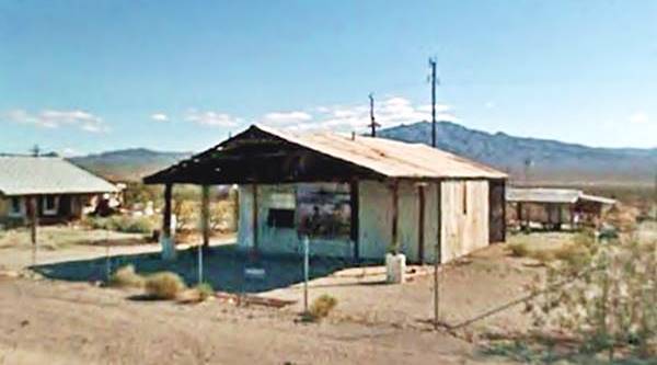
View of the Danby Service Station and its Mural
When the Atchison Topeka and Santa Fe Railroad (in those days it was named Atlantic and Pacific Railroad) acquired the tracks of a competitor SP Railroad from Needles to Barstow in 1884, it built a station at Danby.
The name, like those of all the stations located to the east of Amboy, all the way to Needles followed an alphabetical order (there were exceptions: the small sidings between those stations, which are shown below between brackets)
Amboy, (Saltus), (Altura), Bristol - also Bengal, Cadiz, (Siam), Danby, (Arimo), Essex, Fenner, (Piute), Goffs, Homer, (Bannock), Ibis, (Klinefelter), Java, Khartoum.
So Danby, was the station "D" and it provided water for the steam locomotives used by the railroad.
The name: Danby
It derives from an English surname which in turn refers to families who lived in the area of Danby, Yorkshire, England.
Danby (aldo Denby) comes from "Dane" (Danish -who invaded Britain ca. 900AD) and "by" which means farmstead or village. Therefore Danby means "farm of the Danes".
The railroad is said to have taken the name from towns in the Eastern U.S., so it is probably named after Danby in Vermont.
The Old Woman Mountains, to the west and south west of Danby were named after a rock that resembles the shape of an old woman and was named so by the local Chemehuevi Indians (No-mop-wits : "old woman").
Gold, silver, and carbonates were discovered there in the 1870s, and the area near Danby became a mining zone.
Winton mine was located 7 mi. northeast of Danby and starting in 1893, shipped its gold ore to Danby station where it was moved on by rail to Kingman and smelted there.
Other mines were Wheel of Fortune and Warwick Mine (20 mi. south of Danby) active in the early 1900s.
Thirty miles south of Danby is the Danby Dry Lake, a salt flat, where salt was extracted since the 1890s. It was hauled out on carts drawn by burros (donkeys) and used for processing silver in the nearby mines at Dagget, Fenner, and Danby. The cargo was taken to Danby sation, this went on until the early 1900s when silver price dropped and the salt extraction stopped.
The post office opened in 1893 asa a mail drop for the mines in the area, and when mining declined, the post office closed (1913).
The US Geological Survey along the Santa Fe Railroad in 1915 mentions that "By the judicious use of a small amount of water and fertilizer, date palms, cottonwoods and various other plants have been cultivated at Danby, making the place an oasis in the deser.". Water was piped in from a spring 4 miles to the northwest, in the mountains.
At that time the National Old Trails Highway (N.O.T.) highway was built from Los Angeles to New York, and it followed the Santa Fe railroad, passing through Danby.
Route 66 was aligned using the N.O.T. in 1926 and paved in 1931. It brought tourists and some prosperity to the town, who catered to them. However, when I-40 was built further north in 1973, bypassing the Route 66 segment from Ludlow to Fenner -including Danby, business died and the town became what it is now, some scattered abandoned homes.

Where to Stay: Find your Hotel near Danby
There are plenty of accommodation options on Route 66 in neighboring Needles so you won't have difficulty to book your room in that city:
> > Book your Hotel in Needles
More Lodging Near Danby along Route 66
Below you will find a list some of the towns along Route 66 east and west of Danby; click on any of the links to find your hotel in these towns.
Heading West
- 97 mi. Barstow
- 121 mi. Helendale
- 127 mi. Victorville
- 137 mi. Hesperia
- 151 mi. Cajon Junction
- 163 mi. Fontana
- 165 mi. San Bernardino
- 171 mi. Rancho Cucamonga
- 181 mi. Pomona
- 196 mi. Arcadia
- 201 mi. Pasadena
- 209 mi. Los Angeles
- 216 mi. Hollywood
- 225 mi. Santa Monica
You are so close to Las Vegas!
Click on Deals: Opens in new window
Heading East
Book your hotel in Barstow
Booking.com>> Check out RV campground near Danby
The weather in Danby
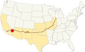
Location of Danby on Route 66
Danby is located in the Mojave Desert; it has a "Subtropical desert climate" with very dry and hot weather including strong thunderstorms during the summer monsoon season.
Summer average high (Jul) is a hot 109.4°F (43°C) and the average low is a warm 78.8°F (26°C). During winter, the average high (Jan) is 68°F (20°C) and the average low is a cool 42.8°F (6°C).
Very little rain falls in Danby: 6.8 in. (173 mm) yearly, over 24 rainy days each year, the dryest months are April to July. Snow is extremely rare.
Tornado risk
Danby is located far to the west of the Rocky Montains so there is virtually no risk of any tornados in this area.
Tornado Risk: read more about Tornado Risk along Route66.
Extreme Heat and Dehydration Warning
During summer make sure you stay hydrated. The hot and dry desert climate can dehydrate you quickly. Drink plenty of water and dress for the heat.
Read more how to keep healthy in hot temperatures.
Map U.S. 66 in Danby
The first alignment of Route 66 in 1926
The first highway was an Auto trails one, built in the 1910s, a dirt track. Map below. Danby appears in it.
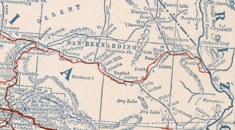
1927 Road map, western CA
Click on image to enlarge.
Credits
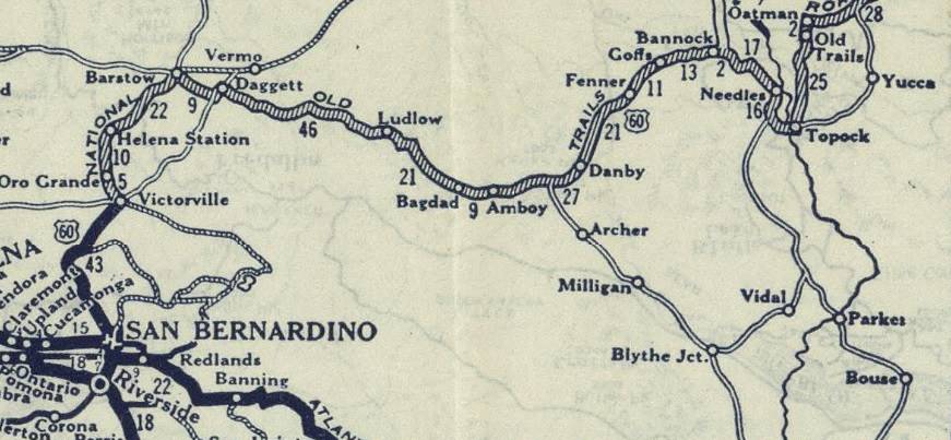
1926 Road map, western CA
Click on image to enlarge.
Credits
The map above (from 1926) -click on thumbnail to see large size map- shows the Highway as U.S. 60! Read why Route 66 was almost named Route 60.
This map is the first to show the alignment of a U.S. highway in Western California.
Road Closures
Updated July 4 2023
Since 2017 Route 66 has been closed west of Fenner all the way to Essex and from there, to Danby and all the way to Chambless. There is complete information, with maps at the San Bernardino County Road Closed web page.
West of Chambless US66 is cut at Apparently Essex Rd. from Essex to I-40's exit 100 is open, so you can go along it, take I-40 westbound and then reach Chambless or Amboy and retake Route 66 has a partial cut on westbound lanes at Kelbaker Rd. But you can reach Chambless from Exit 78.
Westwards from Essex to Danby to Amboy
As mentioned above, the old highway 66 is cut and closed to traffic between Essex and Chambless, this includes Danby, the blue line in our map marks this segment.
Danby
This first N.O.T. westwards from Danby crossed at Danby Station to the eastern ⁄ southern side of the Santa Fe tracks. It remained on that side all the way to Ludlow, passing south of Amboy station.
The Automobile Club of Southern California's Road Map of 1915 shows that road from Danby to Amboy had by then been moved to the northern side of the Santa Fe R.R. and Amboy was shown wiith Gasoline and Oil.
Route 66 was aligned along the N.O.T. road in 1926 and after crossing the broad desert valley to the SW of Danby it crossed the Bristol or Iron Mountains through Summit, dropping down into the basin where Chambless was located in 1932 when the road was paved.
Route 66 Alignment near Danby
With maps and full information of the old roadway.
- Barstow to Pasadena (Next)
- Topock to Barstow (Danby's)
- Kingman to Topock (Previous)
Desert attractions: Danby, California
A Ghost Town on US 66 in the Mojave
Historic context, the classic Route 66 in Danby
Jack DeVere Rittenhouse "Guide Book to Highway 66" written in 1946 provides a clear insight on what Route 66 was like during its Post-War heyday. He mentions Danby very briefly as being ten miles from Essex and that it had:
...A gas station, store, and a garage providing light repairs Rittenhouse (1946)
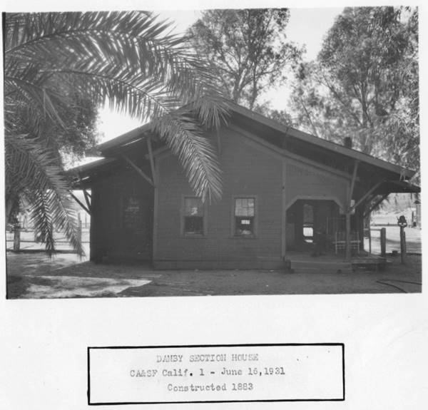
We will tour Danby arriving from Essex by driving west. The town at one time was an oasis as shown in the image below portraying Danby's railroad section house, built in 1883 as it was in 1931.
Mineral Processing Plant - in ruins
At Route 66 and Danby Rd. take a left and head 1.7 mi. towards the railroad tracks to the south. Cross them (with care; look out for trains) and, on the south side of the tracks, next to where the station once stood, at Skeleton Pass Rd. are some ruins of an ore processing plant, rusting in the desert.
This is the map with the location of the Plant.
Head back to Route 66 and head west, to see the Mural on the ruined Service Station.
Service Station & Mural
Just 0.3 mi. south of the junction widh Danby Rd., you will see some buildings, junk, and an abandoned service station to your left, on the south side of the highway.
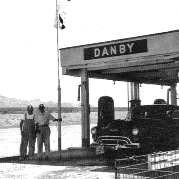
Danby Gas station 1950s US66. Source. Click to enlarge
The gas station was built and ran by a Scotsman named Johnny Neilson and later assisted by his brother Bill. He later leased it from 1955 to 1960 to Slim Hartzler. The place burned to the ground c.1960. It is pictured above and in the thumbnail image (1).
The current ruins of a gas station are of a later date. This is a gabled roof building, a wood frame structure with steel sheet siding with a canopy and has a mural painted on the wall that faces Route 66.
The mural depicts some pioneer day trappers in a forested area with mountains, snow and a lake, an unusual context in such a dry and desert environment.
See the street view of this place.
Rest Area roadside markers
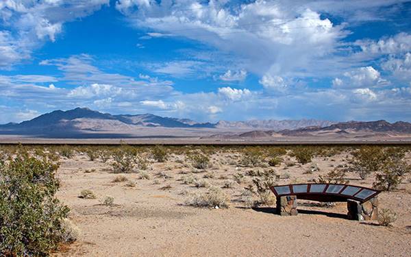
Driving west along the old highway the monument is to your right on the north side of the highway 2.5 miles before your reach Cadiz Summit, 5.9 miles west of Danby. This map marks the spot it describes the highway and the area. Pictured below.
Continue your Road Trip
Your journey through Danby ends here. Continue your road trip by heading west into the village Chambless. Note that US66 is closed due to some bridges having been washed away, so there is a detour to reach Chambless: map.

Sponsored Content
>> Book your Hotel in Needles


Credits
Banner image: Hackberry General Store, Hackberry, Arizona by Perla Eichenblat
Jack DeVere Rittenhouse, (1946). A Guide Book to Highway 66.


