Historic Route 66 in Depew
Depew service station on the 1926-28 Route 66
Index to this page

TheRoute-66.com is reader-supported. When you buy through links on our site, we may earn an affiliate commission at no additional cost to you.
About Depew, Oklahoma
Facts, Trivia and useful information
Elevation: 883 ft. (269 m). Population: 476 (2010).
Time zone: Central (CST): UTC minus 6 hours. Summer (DST) CDT (UTC-5).
Depew is a small town in the southwestern part of Creek County.
Depew's History
For an early history of the region see Tulsa's History.
The town was originally a part of the land belonging to the Creek Tribe in the Indian Territory, which would later become the state of Oklahoma.
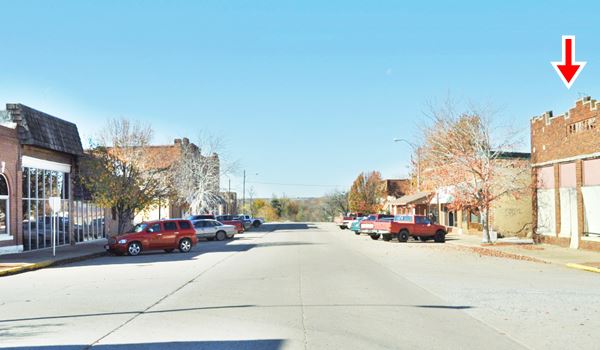
Main Street - Route 66 in downtown Depew, Oklahoma. Red arrow shows the now gone Coppedge Drug Store.
When the St. Louis and Oklahoma City Railroad extended its tracks towards Oklahoma City, in 1898, it built a station and named it Hall. Shortly after, in 1901, Walter F. Malley established a town at Hall and gave it its present name: Depew.

Sen. Chauncey Depew, credits
The Name: Depew
Chauncey M. Depew (1834-1928) was a U.S. senator (R) for New York from 1899 to 1911.
He was a great orator and speaker, and once said: "Speech-making is a tonic to me".
His main focus was the railroad business and he began as a railroad attorney for the N.Y. Central Railroad he eventually became its president.
Later on he was accused of catering to the interests of railway and insurance concerns.
A post office opened and in 1905, the town was platted and lots sold. The school was built in 1909, when the town had 150 residents. It was a rural community, with a cotton gin and some stores.
The oil boom that began in 1915 at nearby Sapulpa did not have much of an impact on Depew, but Route 66 was aligned through the town in 1926 and it brought a steady flow of travelers.
By 1930 the population was 1,126, and began to decline to its current level of 476 in 2010.
The Oklahoma Natural Gas Company built an underground storage plant in 1950 just south of Depew. Nowadays most of the employed residents of Depew commute to work at Bristow or Sapulpa.
As Route 66 became overcrowded and unsafe during the mid-1950s, the interstate I-44 (Turnpike) was built and it linked Oklahoma City with Tulsa bypassing Depew and replacing Route 66.

Accommodation: Where to Stay
There are several hotels in nearby towns along Route 66, close to Depew.
> > Book your Hotel in Chandler or in Stroud
Lodging Near Depew
Heading West
- 11 mi. Stroud
- 32 mi. Chandler
- 67 mi. Edmond
- 80 mi. Oklahoma City
> > There are several RV campgrounds close to Depew in Stroud, Sapulpa and Bristow.
Depew’s Weather

Location of Depew on Route 66
Check the historic weather data for neighboring Bristow
Tornado Risk in Depew, the town is located in Oklahoma's "Tornado Alley and there are around 10 Tornado watches every year.
Read more about: Tornado Risk along Route66.
Map of Route 66 through Depew Oklahoma
Depew's Route 66 maps
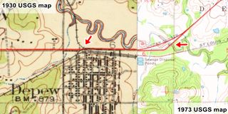
Click on the thumbnail to see a large size map. It combines the 1930 USGS and the 1973 USGS maps of the area. The red line across the map is US Highway 66. The red arrow on the left shows the Little Deep Fork Bridge site, the red arrow to the right shows the two railroad grade crossings that existed in Depew in 1930.
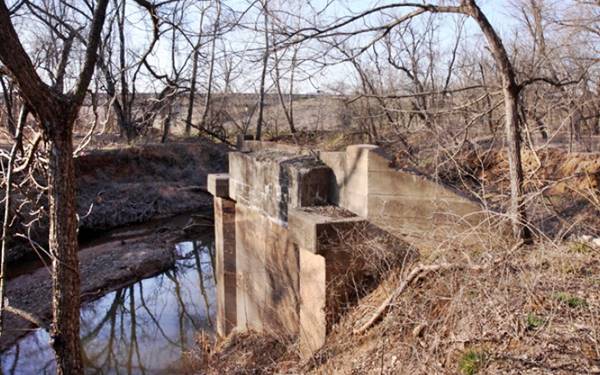
Route 66 runs from Bristow to Depew following different alignments: The first 1926-1928 (see map); ahead it crossed the Little Deep Fork Creek using a steel bridge. The concrete abutements can still be seen (red circle in image). In 1928 the road was moved to its current location and the bridge was also moved (more below at Little Deep Fork Bridge site).
The commercial district in Depew had been paved by the city in 1925, so Route 66 went through the center of the town: south down Flynn Ave. then right along Main St. and again, another right along Ladd. Ave. back to current OK-66.
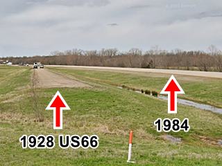
In 1928 it was moved to the north side of the town to avoid the U-shaped alignment and the two grade crossings of the railroad. You can see it, south of the current OK-66 (it was realigned and widened in 1984), between Flynn and Ladd, is the original 1928 paved segment of road, now cutoff from the highway, both alignments are pictured above.
West of Depew
The original 1926 to 1984 alignment ran north of the current alignment (built in 1984), following the course marked in this map with a pale green line. Just ahead the 1926-28 and the 1928-84 alignments split so we will describe them separately.
1926-28 Route 66
It went straight, west (see map as it can be driven here) and then turned 90° south at the cemeteries and followed the alignment shown in the map with a pale blue line, which has vanished and cannot be driven.
At its western tip, it meets the later 1928-84 alignment, and runs on the eastern side of the current OK-66.
1928-84 Route 66
It follows the southern fork, and can be driven in some sections with gaps between them, it runs on the north side of OK-66 (see these two maps of this segment map 1 and map 2). It is pictured below, looking west, you can see the original roadbed on the right, and the newer (1984) one to the left.
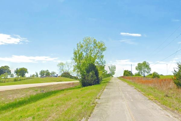
Then it crosses to the south side of OK-66 and follows the 1926-84 alignment west, towards Stroud.
Route 66 Alignment near Depew
Visit our pages with old maps and plenty of information of the old US66 roadway.
- Chandler to Yukon (next)
- Tulsa to Chandler (Depew's)
Route 66 landmarks & attractions
Sights in Depew
Depew Attractions
In his 1946 Guidebook to US Highway 66, Jack Rittenhouse mentions the small town.
US 66 skirts the northern edge of DEPEW... but the only facilities along the highway are gas stations. Rittenhouse (1946)
Little has changes since then; Depew still has a service station on Route 66, on the western entrance to the town.
Little Deep Fork Bridge site
We will tour the town from east to west, starting at the site of the old "Little Deep Fork Creek bridge".
The original 1926 to 28 US 66 alignment ran on the south side of what now is OK-66, you can follow the old segment's alignment in this map, marked in gray.
It crossed the Little Deep Fork Creek along a steel bridge, a single-span Warren Pony Truss that was built in the early 1920s.
In 1928, only two years after Route 66 was created, the roadbed together with the old bridge were moved 100 yards northwards to its current alignment. The old concrete abutements remained in their places and can still be seen (picture below).
The old bridge remained in use on Route 66 for the next 45 years, until it was replaced in 1973 by the present one.
The old bridge on the current alignment, in 1968
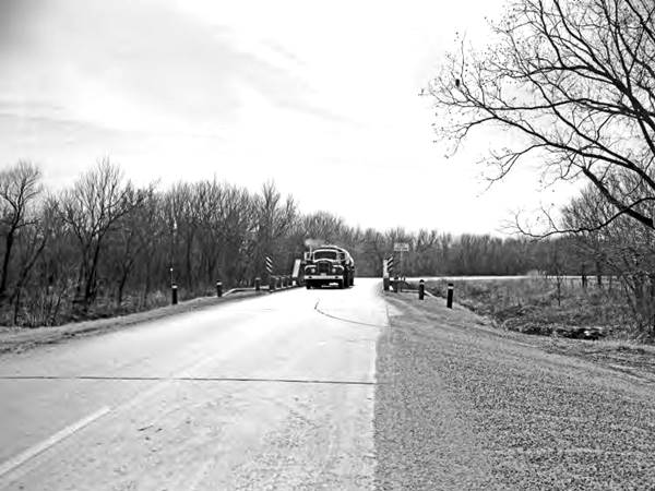
Continue west towards Depew. Below is a "Then and Now" view, looking east. Depew is to the right, then comes the railroad tracks and the 1926-84 Route 66 (red arrow in lower image). The later (after 1984) alignment is to the right (lower image).
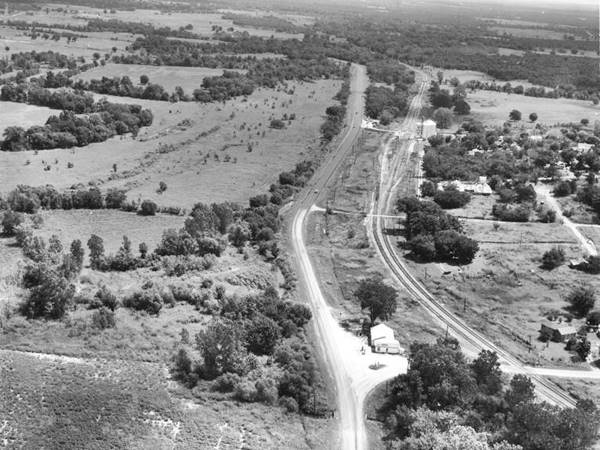
Same view nowadays. Route 66 was shifted north (to the right) in 1984.
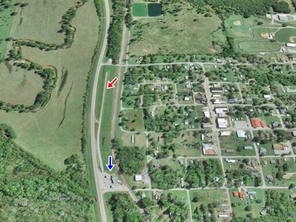
Enter the town along its eastern access road, along Flynn Ave, and you will cross the original 1926-84 roadbed take a right at Main Street. There are several red-brick buildings lining the three-block-long street. Unfortunately Coppedge Drug Store was razed (2013 standing, 2019 gone). The old bank building facing it on the SW corner is still there and is the local police station.
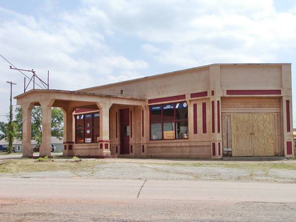
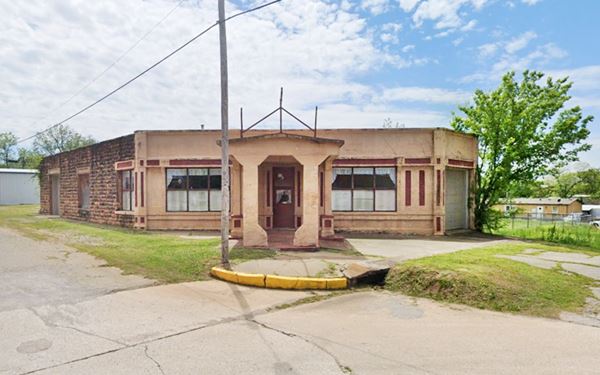
On the next corner, at Malley and Main, to your left is the old "Hicks Filling Station".
Hicks Filling Station
Different webpages call it the "Gimmel Gas Station" or "Gemmill's Auto Parts". However our research indicates that it was first owned by Mr. Hicks. The Oklahoma Route 66. Historic Resource Survey, 1926-1970 conducted in 2002 has an entry for Depew with this site, and says "Hick's Service Station and Garage, Malley and Main, Depew... gasoline service station predating establishment of Route 66."
Vintage 1920s Depew Service Station
In the early 1920s, the local newspaper, The Depew Independent published advertisements of several "garges" that charged batteries, did welding jobs and sold oil and gas. The "Ozark Garage" of Ryan & Snodgrass was one of them, "Quandel Garage", L.D. Mooter's "Ford Service Station" with Oils, Grease and Gas, and the "Bristow Gasoline and Supply Co. that sold oils, gasoline (Texaco and Mobiloil), tools, tubes, and tires were others. There was also a "Quick Service Garage" that repaired tires and J.C. Hubbard was building an "u.-to-date-filling statin" oposite this garage.
The local paper also mentioned (April 8, 1921) the old Hicks station as follows: "O.T. restaurant has a sign in the window, which reads 'Hicks Filling Station, Come in'."
Since it does not appear in the 1915 Sanborn Fire Insurance Map (a "Grocery and B&S" stood on this corner at that time), it must have been built around 1920.
An interesting article with some photographs of its interior show that it had a sign stating "We Honor Texaco Credit Cards" may date back to the early 1970s when during the Arab Oil embargo ('73-74) gas companies only accepted their own credit cards.
We were unabale to find information about Alva and Ed Gimmel (though the Gimmell -with a double L- family lives in the area). The Internet says that they owned the station and it sold Sinclair gasoline at that time.
The building has a residential apperance, with stucco walls facing the corner and Main, a narrow Canopy with low-pitched gabled roof held up by four tapered columns with oversized stylized capitals. There are two parallel pump islands with a narrow entrance. Pumps have been removed.
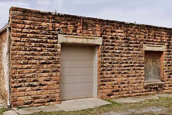
Along Malley the building has a solid rock wall, with a service bay (the other one faces Main) and the words "Drive In" written across the door's head jamb.
Mayberry Garage & station(?)
Continue one block west and turn right to head back nortwards to leve town. At the railroad crossing you will see a gas station to your right, this is one of those mentioned by Rittenhouse (shown in the aerial views further up).
Delbert Mayberry owned the "Mayberry garage and service station" in Depew from 1951 until he retired before their tragic death in 1971 (he, and his wife Nadine died in a car-train collision crossing these tracks in Depew). We haven't been able to locate where the service station stood, but it is probably the one at the crossing.
Your City Tour through Depew ends here, you can turn right and head west along Route 66 towards Stroud and drive the Depew to Stroud US 66 alignments.
Some sponsored content
> > Book your Hotel in Stroud


Credits
Banner image: Hackberry General Store, Hackberry, Arizona by Perla Eichenblat
Jack DeVere Rittenhouse, (1946). A Guide Book to Highway 66
Jim Ross Historic US 66 Bridge Database 1926-85
Linda D. Wilson Depew, Encyclopedia of Oklahoma History and Culture


