Route 66 in Dilia NM
Index to this page
About Dilia, New Mexico
Facts, Trivia and useful information
Elevation: Elevation: 5,240 ft (1.598 m). Population: n⁄a.
Time zone: Mountain (MST): UTC minus 7 hours. Summer (DST) MDT (UTC-6).
Dilia is a small community located on the junction of NM-119 and US-84 in Guadalupe county. It is the easternmost of a series of farming communities that employ the water of the Pecos River for their farm land. It is on the northern edge of Guadalupe County.
History
People have lived in this part of New Mexico for at least 10,000 years, the Pecos River was a main route linking the Sangre de Cristo Mountains in the north with the plains and the Llano Estacado in the southeast, the Pecos Trail.
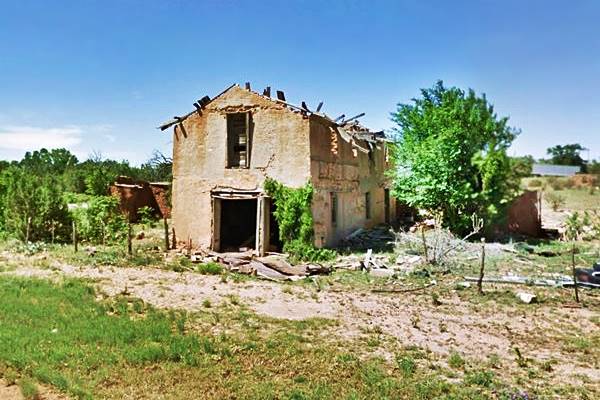
Ruins of adobe building in Dilia, New Mexico
The area was explored by the Spanish expedition led by Coronado, who passed through Pecos (north of Dilia) and Santa Rosa (south) in 1540. New Mexico became a part of the Spanish colonial territories in America in 1598. However, there was no settlement in this area at that time. The Pueblo Revolt of 1680 expelled the Spaniards who returned and reconquered the region in 1693 subduing the natives.
The Spaniards' easternmost outpost was in the foothills of the Rocky Mountains, in Pecos Pueblo, and that village was subjected to the constant raids of the Apache and Comanche warriors of the plains. Later settlement attempts further north in the early 1800s were short lived.
There were other settlements extend south along the Pecos River: Tecolotito, Anton Chico and La Loma; they originated in a land grant of the 1820s, but they too were abandoned until the 1850s.
After Mexico became independent from Spain, it received New Mexico (1821) but later lost it to the U.S. after being defeated during the Mexican - American War (1846 - 48). After the war, the region became the US Territory of New Mexico and the U.S. Army pacified the Kiowa, Kiowa Apache and Comanche natives allowing farmers to settleme here in Dilia in the mid-1850s.
There was a post office here between 1911 and 1968 when it moved to La Loma. It was also known as "Vado de Juan Paiz" or Juan Paiz's ford -across the Pecos River.
The Name: Dilia
It is supposedly named after the daugher of one of its first settlers. Perhaps a corruption of Delia, a Spanish name that means "who comes from the Island of Delos" and means delicate, after the Greek godess Artemis, who came from that island.
Route 66 was aligned through the town in 192 and a bridge crossed the Pecos river south of it. The town was such a small community that it does not appear on the 1927 Road Map printed by Rand McNally. (Anton Chico is the only town shown in the area).
After 1937, Route 66 was realigned along a shorter course from Santa Rosa to Albuquerque through Moriarty and the road through Dilia became US 84 a new bridge was built to carry it across the Pecos, and it was realigned on the eastern side of the village.

Where to Stay near Dilia
There are plenty of accommodation options and lodging along Route 66 close to Dilia:
> > Book your room nearby in Las Vegas (NM) or Santa Rosa
More Lodging Near Dilia along Route 66
Below you will find a list some of the towns along Route 66 to the east and west, with hotels and accommodation; click on any of the links to find your hotel in these towns.
Heading West
- 33 mi. Las Vegas NM
- 86 mi. Santa Fe
- 112 mi. Albuquerque
- 170 mi. Acoma Pueblo
- 190 mi. Grants
- 250 mi. Gallup
Heading Main Route 66
- 75 mi.Moriarty
- 34 mi. Santa Rosa
- 93 mi. Tucumcari
West on The Santa Fe Route 66 segment
- 31 mi. Las Vegas New Mexico
Find your room nearby, in Santa Fe
Booking.com>> There are RV campgrounds close to Dilia in Santa Rosa.
Weather in Dilia
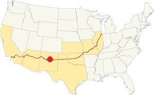
Location of Dilia on Route 66
Dilia is located in a very dry area with about 15 inches (381 mm) of rainfall per year. Summer is hot but during the temperature drops during the night. Winters are cool.
Rainfall is higher during the summer with intense downpours: Between May and the end of Sept. around 9.5 in. of rain falls (241 mm).
Snowfall is moderate with an average of 13 inches of snow (33 cm). You may encounter snow at any time between Sept. and May but most (10 in. falls from Dec. to Feb.)
Average high temperature in summer (July) is about 92°F (33.3°C). In winter (Jan) the high is 54°F (12.s°C). The average low in summer is 61°F (16.1°C) and the winter low is below freezing, at 24°F (-4.4°C).
Tornado risk
Dilia is located in an area with virtually no tornado risk: Guadalupe county only has two (2) Tornado watches per year.
Tornado Risk: read more about Tornado Risk along Route66.
Map of Route 66 in Dilia, NM
The original Route 66 was aligned through Santa Fe in 1926 along three previous highways, the "Ozark Trail", the "Santa Fe Trail" and the "National Old Trails".

1925 Road map, Central NM
Click on image to enlarge.
Source
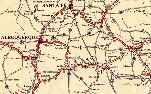
The thumbnail map above from 1925 (click on it to see the full sized map) shows the roads that existed one year before Route 66 was created.
Notice Dilia on the lower right side of the map.
Those marked "22" (National Old Trails Rd., coming from Los Angeles) and "32" (New Santa Fe Rd.) with white letters in a black box, went from Gallup to Albuquerque and through Santa Fe. Highway "50" was the Ozark Trails it ran through Dilia.
The only paved sections (full black line) were between Albuquerque and Bernalillo, and Albuquerque and Tijeras. The highway from Bernalillo to Santa Fe, and beyond Isleta was "improved" (dashed line), the rest were either graded or dirt roads.
The Santa Fe Loop (1926 - 1937)
This was the first alignment of Route 66, from Santa Rosa to Albuquerque via Pecos (and Dilia) to Santa Fe.
We describe this segment in our Santa Fe Loop page, a dedicated webpage, with the full alignment, from Santa Rosa, through Dillia, Pecos, Santa Fe, Santo Domingo, and Bernalillo all the way to Albuquerque.
This original highway also continued beyond Albuquerque to Isleta, Peralta and Mesita.
Map doesn't show Dilia, only Anton Chico near it:
1937 Realignment of Route 66
A political dispute between New Mexico Governor A. T. Hannett and local politicians led to the realignment of Route 66 in 1937.
Hannett blamed the local party bosses when he lost his 1927 bid to re-election. He decided to punish them, and their backers (the business men in Santa Fe) so he quickly had state highway #6 built, in 1927, to link Moriarty with Albuquerque. This highway bypassed the capital city, and was 90 miles shorter for those driving from the east to Albuquerque.
In 1937, the Federal roadbuilders decided to realign Route 66 using Hannett's road, and paved it. It was a straighter highway, and only had a short mountain segment across the Sandia Mountains between Sedillo, Tijeras and Carnuel.
Route 66 Alignment near Dilia
With maps and full information of the alignments of Rte. 66.
- Albuquerque to Lupton (next)
- Santa Rosa to Albuquerque 1937-85 (parallel)
- Tucumcari to Santa Rosa (previous)
The Santa Fe Loop (1926 - 1937)
Our Santa Fe Loop page describes the complete 1926 to 1937 alignment of Route 66 from Santa Rosa to Albuquerque through Pecos, Santa Fe and Bernalillo.
Dilia: its Attractions
Landmarks, Route 66 sights
Dilia is a small village on the 1926 to 1937 alignment of Route 66 between Santa Rosa and Santa Fe. No buildings survive from this period except the abutements of the washed-out bridge that carried it across the Pecos River. Visit Dilia's church.
Old Pecos Trail
This trail was never a formal trail like the Santa Fe Trail, its first part, linking Santa Fe and Pecos was part of the Santa Fe Trail and well marked. To the south, it was a path mostly unfit for wagons. It ran along the Pecos River valley linking some small villages on the way, to Puerto de Luna, south of Santa Rosa.
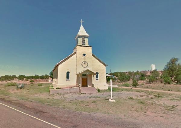
Sacred Heart Church
The Sagrado Corazón church is very close to US-84; take a left along NM-119 to reach it. It was built in 1900.
Sacred Heart Church at Dilia, NM
Tours & Itineraries
Aurupa Archaeological Site
Before the arrival of the Spaniards, the Pueblo people extended south out of the Rocky mountains and built some small settlements along the Pecos River. The Spaniards also settled here, one of these places is located at Aurupa (Map showing the spot). It can be reached by driving to it, 3.3 miles to the west of US 84. See the Map with Directions
The Pecos River was critical to the local people; it was a main trade route between the Pueblos and the Natives of the Plains; its water was used to irrigate the crops.
Etiquette at an Archaeological Site
Leave no trace, only take photographs. Remember that cultural sites are degraded by unintentional damage caused by visitors. View from a distance to reduce impact. Leave artifacts where they lie (potsherds, flints). Don't move rocks, branches. Don't touch plaster walls. Don't touch rock art. Don't climb on walls or roofs. Pets should not enter archaeological sites.
Archaeological sites are protected by local, federal and state laws and they provide for prosecution with fines and⁄or imprisonment of violators.
The washed out Pecos River Bridge
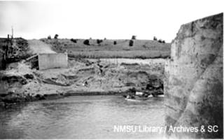
1937 washed out Pecos river bridge, Dilia. Source
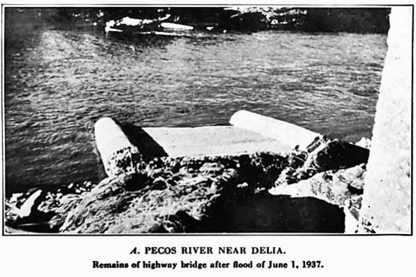
The current course of U.S. 84 more or less follows Route 66, but it isn't the exact alignment. For instance, there was a bridge across the Pecos river south of Dilia 3⁄4 miles west of the current one, it was washed away by the 1937 flood and only its abutements survive (see picture). The highway south of the river is gone, northwards it enters Dilia.
In our custom map, we use a green line to show the 1926-37 Dilia alignment, and the green marker in the map shows where the bridge was located.
Ruins of adobe building in Dilia, New Mexico
Pecos River
The River flows through Dilia and has been a route since prehistoric times. To the north, in the Sangre de Cristo Mountains near Santa Fe are the river's headwaters of the river at over 12,000 ft. (3.700 m). To the south is the Rio Grande which the Pecos reaches after flowing for 926 miles (1.490 km). It drains a vast area of almost 45,000 sq. mi. (115.000 km2).
For those interested in the old U.S. 66 alignment, north of Dilia, there is another stretch of the 1926 highway to the west of modern US 84, it includes a culvert; see the green line in our custom map. The green marker is the culvert.
End of this leg of your Road Trip
Here on the north side of Dilia is the end of this leg of your journey. Continue your road trip by heading north and visiting the next stop: Romeroville.

Some sponsored content
> > Book your Hotel in Santa Fe

Credits
Banner image: Hackberry General Store, Hackberry, California by Perla Eichenblat


