Your Route 66 Road Trip in Gascozark
Index to this page

TheRoute-66.com is reader-supported. When you buy through links on our site, we may earn an affiliate commission at no additional cost to you.
About Gascozark Missouri
Facts, Trivia and useful information
Elevation: 1,058 ft (323 m). Population n⁄a (2010).
Time zone: Central (CST): UTC minus 6 hours. Summer (DST) CDT (UTC-5).
Gascozark is a small unincorporated community located on old US 66 in Pulasky County, in the Ozarks in South central Missouri.
History of Gascozark
For the general history of the area check the History of Waynesville.
Pulaski County was created in 1833 and named after Kazimierz Pułaski, a Polish citizen who died fighting against the British during the American Revolution War. The area was on the road linking Waynesville westwards towards Lebanon. This went through Debruin, close to present Buckhorn, Laquey and then the now defunct settlements of Bellefonte, Flynn and Francis (they had post offices at one time) before crossing the county line and reaching Hazelgreen.
The name: Gascozark
Named by Frank Jones, owner of the cafe, it combined both name, that of the "Gasconade River" and the "Ozarks" region.
The "Wire Road" built during the 1860s to service the telegraph line from St. Louis to Fort Smith in Arkansas, passed near Gascozark, and would become the main road from St. Louis to Springfield and Joplin, becoming State Hwy. 16 in the early 1920s and U.S. 66 in 1926. Later during the 1950s, Route 66 was upgraded to a four-lane freeway and its alignment straightened out, it bypassed the town. And Route 66 became Missouri Supplemental Route AB.

Getting to Gascozark
Use historic Route 66 and Interstate I-44 coming from Springfield, Tulsa and Oklahoma City in the west, or from Rolla, Cuba, or St. Louis in the east.
Hotels on Route 66 close to Gascozark
There are no hotels in Gascozark. You can find plenty of accommodation options nearby in neighboring Lebanon.
> > Book your hotel in Lebanon
More Hotels near Gascozark
Below we list some towns along Route 66 with a link to their lodging options. Click on any of the links to find your hotel in each of these towns.
Hotels Westwards, MO, KS, OK
- 18 mi. Lebanon
- 48 mi. Marshfield
- 60 mi. Strafford
- 73 mi. Springfield
- 133 mi. Carthage
- 150 mi. Joplin
- 166 mi. Baxter Springs
- 181 mi. Miami
- 197 mi. Afton
- 212 mi. Vinita
- 249 mi. Claremore
- 259 mi. Catoosa
- 272 mi. Tulsa
Accommodation Heading East in Missouri
- 15 mi. Waynesville
- 18 mi. Saint Robert
- 44 mi. Rolla
- 55 mi. Saint James
- 69 mi. Cuba
- 87 mi. Sullivan
- 102 mi. Saint Clair
- 114 mi. Villa Ridge
- 120 mi. Pacific
- 130 mi. Eureka
- 148 mi. St. Louis
>> Check out the RV campgrounds in Lebanon
Weather in Gascozark

Location of Gascozark on U.S. Hwy. 66
There are clearly defined seasons in Gascozark. During summer, the average high (Jul) is 88°F (31.2°C), while the average low in 67°F (19.2°C). During winter (Jan) the average high is 42°F (5.6°C) and the average low is below freezing at 20°F (-7°C).
Rainfall averages 44.5 in (1.131 mm) per year and falls regularly each month in roughly the same amount. Snowfall is around 9 in. (23 cm), and falls between Dec. and Mar.
Tornado risk
Gascozark is located in the "Tornado Alley" and Pulaski County is hit by some 8 tornado strikes every year.
Tornado Risk: read more about Tornado Risk along Route66.
Map of Route 66 in Gascozark MO
U.S. 66 Alignment and maps in Gascozark
The 1926-52 Route 66 coming from Waynesville, headed west into Gascozark following the alignment shown in this map.
Later ta four-lane highway was built where the freeway is situated nowadays, bypassing the original roadbed.
The Route 66 alignment in Gascozark
Visit our pages, with old maps and plenty of information about US 66's alignments.
- Springfield to Joplin (next)
- Rolla to Springfield (Gascozark's)
- Gray Summit to Rolla (previous)
Route 66 Sights in Gascozark
Route 66 Village in the green Ozarks
Historic context, the classic Route 66 in Gascozark
Jack DeVere Rittenhouse's "A Guide Book to Highway 66" published in 1946 and mentioned this village and gives us an idea of what the old road was during its heyday.
... you reach GASCOZARK, a small community consisting of a store and two gas stations. Rittenhouse (1946)
He also added that 1, 3 and 7 miles east of the village there were gas stations. Two of these remain.
Your Road Trip through Gascozark
We will tour the area from east to west, coming from Laquey and through Gascozark driving towards Hazelgreen.
Roughly 0.4 miles west of the junction of Route 66 and Smokey Rd., to your left is the site of an old "Court".
Spring Valley Court
See this Map showing the spot. This complex was built around 1929 when Route 66 was only three years old.
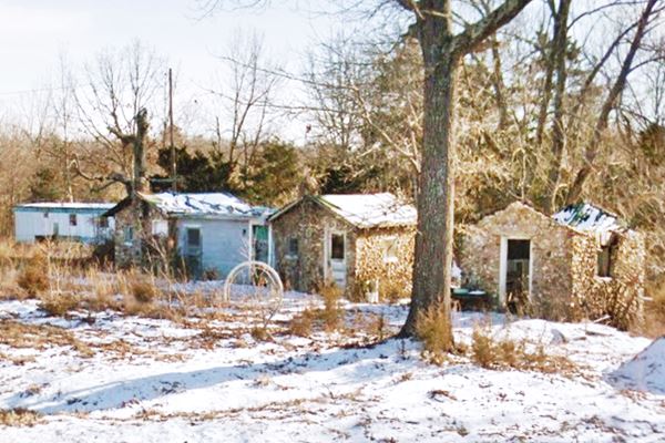
It had four rock cabins and a shower house. All of them built in rock. The roadhouse on the western side of the property functioned as a store and cafe. It was named after a spring below the house.
Now it is private property.
Former cabins at Spring Valley Court in Gascozark, Missouri

Drive west, the highway meanders in a forested area with rolling hills. After 2.1 miles you will reach an old gas station and former motel.
Central Motel and gas station
Ed Lentz owned this motel and filling station until it was bypassed by the new four-lane alignment of Route 66 (now buried under I-44's roadway) in the early 1950s forcing him to relocate to the "new" highway in neighboring Hazelgreen, where he opened the Oasis motel and Mobil station.
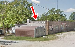
The remaining building on the north side of the highway, to your right, at Snipe Rd. and US 66, consists of a one door garage and an office. You can see the outline of the old pumps island. The "Then and Now" sequence below marks the building with a red arrow.
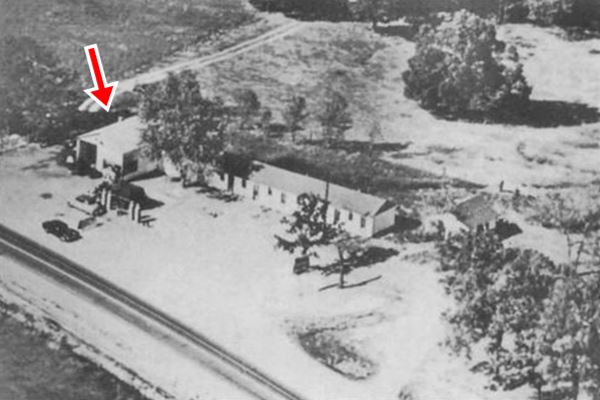
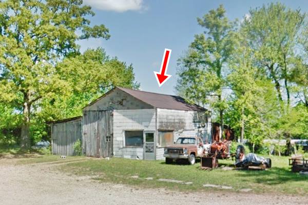
The motel was a long gable roof building parallel to the highway, to the right of the gas station. You can see it in the old photograph, and the foundations can still be seen in the grass; as you can see this satellite view.
Lentz had chosen the spot known as "Dadtown", where the Lewis ("Dad" and Betty) had set up a mill and general store in the early 1900s.
The road turns westwards and there are more buildings as you approach Gascozark, a semi-urban setting. At the top of a hill, to your right is the old cafe and filling station.
Gascozark Cafe and Service Station
North side of Route 66 Facing Spring Rd. Frank Jones settled there in 1931, on Route 66 and opened a café and service station which he gradually expanded. He hired a stonemason to give them a uniform appearance, and that it how this giraffe-rock structure also called slab-rock was created.
He later sold it ca. 1935 to the Shuermanns. It was also known as the "Spinnng Wheel café". The pumps to the east of the building sold D-X branded gasoline at one time (see the sign and D-X truck in the picture below).
The building has a neat curved parapet giving it a peculiar appearance.
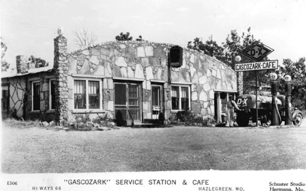
Gascozark Cafe and gas station in Gascozark, Missouri
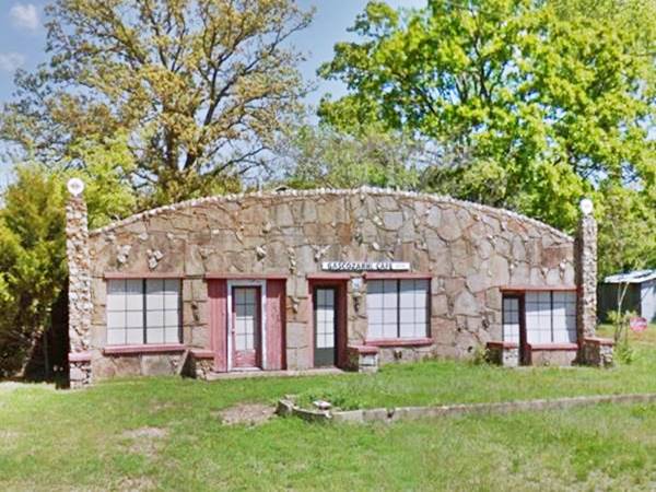
Gascozark Trading Post or Caldwell's Café
Across the street from Gascozark cafe, to your right. The current trading post was originaly known as "Caldwell's Café" and owned by David Caldwell and it included a store and a filling station.
At one time sold APCO Gasoline, the sign is the original one but the word APCO has been replaced.
Below is a 1939 photograph. The tiles along the edge of the roof (red arrows).

Gascozark Trading Post in Gascozark, Missouri
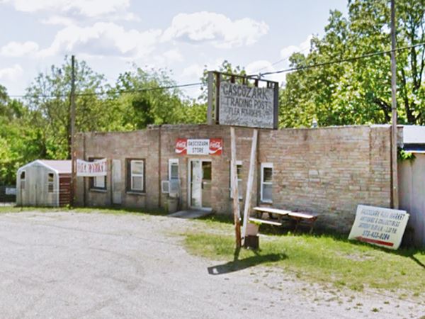
Caldwell's Cabins and Court
Behind the trading Post it had four double cabins, and som of them have survived. You can get a good view of them from Spring Road.
To the right of the old Caldewll Trading Post and the cabins, to your left is Spring Road, which takes you (only 1 mile away) to a 1930s Resort.
Gasconade Hills Resort
28425 Spring Road, 1 mi. east of Route 66. This is the Map showing its location.
Built by Frank Jones in 1937 , it took advantage of the large flow of tourists flocking to the Ozarks and offered cabins and a lodge on the Gasconade River. It is still open and the original buildings are still there (www.gasconadehills.com). Street View.
Return to Route 66; your city tour of Gascozark ends here.
You can continue your Route 66 road trip by heading west to visit Hazelgreen.

Some sponsored content
> > Book your hotel in Lebanon


Credits
Banner image: Hackberry General Store, Hackberry, Arizona by Perla Eichenblat
Jack DeVere Rittenhouse, (1946). A Guide Book to Highway 66


