Your Route 66 Road Trip in Hazelgreen
Index to this page

TheRoute-66.com is reader-supported. When you buy through links on our site, we may earn an affiliate commission at no additional cost to you.
About Hazelgreen Missouri
Facts, Trivia and useful information
Elevation: 1,012 ft (309 m). Population n⁄a (2010).
Time zone: Central (CST): UTC minus 6 hours. Summer (DST) CDT (UTC-5).
Hazelgreen is located on old US 66 in northwestern Laclede County, in the Ozarks in South central Missouri.
Old Route 66 bridge across the Gasconade River, Hazelgreen, Missouri
History of Hazelgreen
For the general history of the area check the History of Waynesville.
Hazelgreen is a small unincorporated community -a scattering of houses- on the original Route 66 alignment. The later four lane US 66 which became I-44 runs next to it, west of the old road. The freeway cut the town in two, and part of it lies next to Exit 145.
Settled in the 1840s (as shown by some tombstones in the Cemetery), the post office opened in 1858, and closed one century later, shortly after the freeway was built.
The name: Hazelgreen
Named after the hazel bushes (Corylus) near the town. These are deciduous trees and shrubs native to the temperate Northern Hemisphere, their fruit is the hazelnut.
The "Wire Road" built during the 1860s to service the telegraph line from St. Louis to Fort Smith in Arkansas, passed near Hazelgreen, and would become the main road from St. Louis to Sprignfield and would become State Hwy. 16 in the early 1920s and U.S. 66 in 1926. Later during the 1950s, Route 66 was upgraded to a four-lane freeway and its alignment straightened out, it bypassed Hazelgreen.
Getting to Hazelgreen
Reach Hazelgreen using Route 66 or Interstate I-44 that link it with Springfield in the west and with Cuba to the east. US 160, 60 and 65 run to the west, through Springfield, US 63 runs through Rolla, to the east.

Where to Lodge in Hazelgreen, Missouri
There are no hotels in Hazelgreen, but you can find your accommodation nearby in neighboring Lebanon.
> > Book your hotel in Lebanon
More Hotels close to Hazelgreen
Below we list some towns along Route 66 with a link to their lodging options. Click on any of the links to find your hotel in each of these towns.
Hotels Westwards, MO, KS, OK
- 16 mi. Lebanon
- 46 mi. Marshfield
- 59 mi. Strafford
- 72 mi. Springfield
- 131 mi. Carthage
- 149 mi. Joplin
- 164 mi. Baxter Springs
- 179 mi. Miami
- 195 mi. Afton
- 210 mi. Vinita
- 247 mi. Claremore
- 257 mi. Catoosa
- 270 mi. Tulsa
Accommodation Heading East in Missouri
- 16 mi. Waynesville
- 19 mi. Saint Robert
- 45 mi. Rolla
- 56 mi. Saint James
- 70 mi. Cuba
- 88 mi. Sullivan
- 103 mi. Saint Clair
- 115 mi. Villa Ridge
- 121 mi. Pacific
- 131 mi. Eureka
- 149 mi. St. Louis
>> Check out the RV campgrounds in Lebanon
Weather in Hazelgreen

Location of Hazelgreen on U.S. Hwy. 66
There are clearly defined seasons in Hazelgreen. During summer, the average high (Jul) is 88°F (31.2°C), while the average low in 67°F (19.2°C). During winter (Jan) the average high is 42°F (5.6°C) and the average low is below freezing at 20°F (-7°C).
Rainfall averages 44.5 in (1.131 mm) per year and falls regularly each month in roughly the same amount; snowfall is around 9 in. (23 cm), and falls between Dec. and Mar.
Tornado risk
Hazelgreen is located in the "Tornado Alley"; Laclede County has some 8 tornado strikes per year.
Tornado Risk: read more about Tornado Risk along Route66.
Map of Route 66 in Hazelgreen MO
U.S. 66 Alignment and maps in Hazelgreen
The 1926-52 Route 66 headed west into Gascozark (map), and onwards into Hazelgreen and across the Gasconade River along the historic bridge that is now closed to traffic and bypassed by a brand new one that opened in 2018. (map of US 66 through Hazelgreen).
On the south side of the river, in "Richland", the highway continues westbound towards Lebanon.
But the alignment isn't what is now signed as Route 66. Instead, after crossing the bridge, the highway cruved right to the north. Now it is cut by I-44 (see the Red line in this Interactive Map at Hazelgreen), then it runs along the north side of the freeway as its frontage road, (Pale Blue line in the map) Hidden Hills Road as also shown in this map for 1.6 miles before turning southwards (cut nowadays by I-44 as marked with the Blue line in the map). On the south side of the freeway it heads west towards Lebanon as US Route 66. The current Route 66 from the bridge to County Rd. N was built after the freeway, as a frontage road.
The Route 66 alignment in Hazelgreen
Visit our pages, with old maps and plenty of information about US 66's alignments.
- Springfield to Joplin (next)
- Rolla to Springfield (Hazelgreen's)
- Gray Summit to Rolla (previous)
Route 66 Sights in Hazelgreen
Landmarks and Places to See
Historic context, the classic Route 66 in Hazelgreen
Jack DeVere Rittenhouse published his "A Guide Book to Highway 66" in 1946 and he mentioned the village.
.Pop. 45; gas; store; small hotel...Rittenhouse (1946)
He added that like many towns in the Ozarks its economy was based on fishermen and tourists that visited the area. They also sold pottery and handicraft. He mentioned that on the southern bank of the Gasconade River was "Eden Resort, one of the best accommodations in this region", and on the western side of the road were "public stone picnic tables", the Roadside Park.
We will begin oour tour of Hazelgreen driving westwards from Gascozark and heading towards Lebanon. At Missouri State Hwy. 133, is the access to I-44's Exit 145, and it marks the county line, you will leave Pulaski County and enter Lacleded County.
Take a short detour to visit a 1950s Route 66 gas station. On the last alignment of the Mother Road, the four-lane super highway built in the 1950s. Turn right along MO-133 take the overpass, and on the north side of the freeway turn left onto the frontage road (Holiday Hills Rd.) drive west, after 0.5 mi. is the site of the old "Oasis" motel and gas station.
Lentz's Oasis motel and station
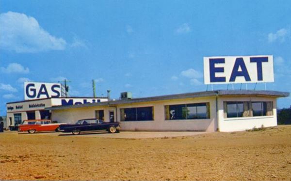
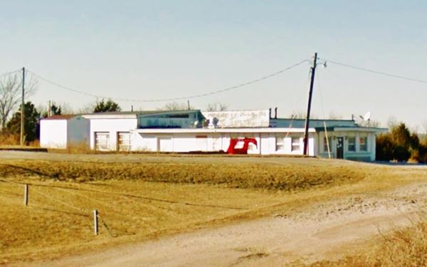
Ed Lentz owned a Central Motel and station east of Gascozark, but it was bypassed by the new four-lane alignment of Route 66 (now buried under I-44's roadway), so he moved to a new location on that "new" highway and opened "Oasis". It advertised as having "24 Hour Service Oasis Motel & Restaurant Mobil Jct. 66 & 133 Richland, MO." Notice how it says it was in Richland, a town that is 6.5 mi. north of old Route 66.
Four-Lane Route 66
This roadway was built with 1950s standards, meaning that it had four lanes, and it was a divided highway, with a median grass strip, however it still had at-grade or level crossings, the traffic could leave the highway and access gas stations or motels along its alingment. The concept of limited access - grade separated junctions (i.e. interchanges) evolved towards the end of the 1950s.
So traffic along the 1950s Route 66 could exit the highway at Lentz's Oasis cafe and Mobil gas station with no problems. But later, he was cut off when the interchange was built at MO-133.
Below is a "Then and Now" sequence of the Oasis or Lentz Truck Stop. You can also see it in the upper right corner of this aerial photo from 1955 (notice the level crossings on the 4-lane highway).
Turn around and head back to the old Route 66 alignment on the south side of the freeway, turn right and head west. Ahed is a "Gull Wing" Phillips 66 service station.
Old Phillips 66 Gull Wing Service Station
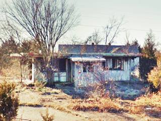
To your left among the shrubs, vines and trees you will spot the ruins of the former gas station.
Old Phillips 66 Service Station in Hazelgreen, Missouri
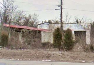

Vegetation overgrowing the "New Look" Hazelgreen station
This is probably the "gas" mentioned by Rittenhouse in 1946, though at that time it would have been an ice-box style station. The gas station has the typical gull-wing-shaped triangular canopy with a red trim. There is a two-bay garage and the building was constructed in concrete blocks (probably the original one).
Behind it stands a tall tower with vines growing on it. There is no singpost standing at the apex of the canopy. It was abandoned around 1971 and is in ruins.
>> Learn more about the Phillips66 Gull wing stations on Route 66.
Tavern
Next to the gas station (just west of it) is what used to be an old tavern, now in ruins. It closed during the 1990s. You can see it in the lower left corner of this aerial photo from 1955. Pictured below.
Hazelgreen Cemetery
Just ahead, to your left on the eastern side of US 66. It dates back to 1840. Pictured above.
Head west to visit the old historic Gasconade River bridge. It is closed to traffic and a new bridge has replaced it and you can use it instead, see map.

Route 66 in Gasconade River
Click on map to enlarge (see Bing map)
Gasconade Bridge
Closed to traffic
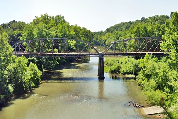
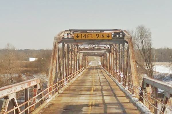
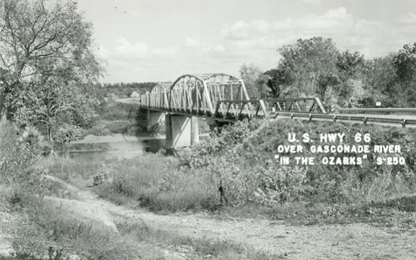
This steel through-truss bridge predates Route 66 because it was built between 1922 and 1924 (U.S. 66 was created in 1926). Originally it carried Missouri State Highway 14 and was designed by the Missouri Highway Department. It has three spans and since the opening of the four-lane highway on Route 66 in the 1950s, was neglected in maintenance and repairs, deteriorating to such an extent that in 2014 it was permanently closed to traffi>.
The Missouri DOT wants to tear it down, but a group of Route 66 activists want to save it (just as the bridge in Pulaski County at Devil's Elbow was restored and preserved).
A new bridge was built to the north of it, beside the freeway and Route 66 was linked to it (see map).
View of the Route 66 Gasconade River Bridge today, in Hazelgreen, Missouri
View of the Route 66 Gasconade River Bridge in a vintage postcard in Hazelgreen, Missouri
Gasconade River
Its sources are in the Ozarks and it has a roughly north - northeast course along 280 mi. (450 km) before meeting the Missouri River near the town of Gasconade in Gasconade County.
Its name derives from the French region of Gascony, and the French trappers who explored the area in the 1600s applied that name to the Indians that lived at the mouth of the river because they were boastful just like the people from Gascony.
Two rivers that Route 66 crosses in the area, the Roubidoux Creek and Big Piney River, flow into the Gasconade. There are many scenic bluffs as the river cuts through the Ozarks with a meandering course (it is said to be one of the "world's crookedest rivers").
Eden Resort

Route 66, aerial view at Gasconade River in 1959
Click on map to enlarge. A. Whittall, source
Take the new road and bridge and cross to the western side of the river and drive to the original Route 66 by the old bridge. Here, on the south side of the highway (with your back to the river it is to your left) was Eden Resort, that Rittenhouse described in 1946 as "one of the best accommodations in this region." Stanley M. Riggs built his "Paradise in the Ozarks" in the 1920s. Then in 1946 he sold it to its final owners, the Dicksons, Walter and Helen. Over the years the complex had cottages, running water, restaurant and offered fishing excursions and river float trips. In the late 1950s, the freeway isolated it as it was three miles from the nearest exit. It closed, was torn down and vanished.
Roadside Park
Facing Eden Resort, on the north side of the highway. Rittenhouse says it had "public stone picnic tables," it was located in a ravine with steps leading to it from the roadside. Riggs donated the 1.6 acres of land for a park. There was an obelisk in the park with a bronze marker that read "To commemorate the March of Union Soldiers - St. Louis to Springfield overland via Wire Road 1861-1865 Civil War. Erected 1931 by American Circle #62, Ladies of the G.A.R., St. Louis, Mo."
It had a road along its western flank, and Route 66 on the east. See this aerial photo from 1955 where the lense shaped park can be seen in the middle of the image.
The park was razed and partly filled in when I-44 was built. The obelisk and marker vanished.
West of this point, the original Route 66 is now cut by I-44 as marked with a Red line in this Interactive Map at Hazelgreen, then and continues on the north side of the freeway as Hidden Hills Road (Pale Blue line in the map) but to reach it you have to drive 5.8 miles (map with directions). What is now called Route 66 on the soth side of I-44 was built in the 1950s as a frontage road for the Interstate.
There is only one remaining Route 66 site on that road segment, Harper Skelly.
Al Harper Skelly

Harper's Skelly station. Credits
To your right (see map); it was built in the early 1950s when Route 66 became the westbound lanes of the new four-lane highway (remember, it had level crossings). Charley Gilmore owned it. He sold it to Al Harper who sold Skelly gas. The place closed when a new set of westbound lanes were built and I-44 became a limited access freeway.
After 1.6 miles, the original US 66 turned southwards (cut nowadays by I-44 as marked with the Blue line in the map). Here was the junction with County Rd. N. It was the site of a large truck stop: "Brownie's" also known as "The Harbor", cafe and cottages. It had a Mobil gas station, several independent cabins and a two-story gable roof stone building. It was razed to make way for I-44.
Head west towards Lebanon along US Route 66 on the south side of the freeway. There is one final classic site ahead.
Riley's Snack Bar and Souvenirs
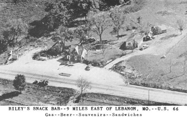
Drive 1.9 mi west from Co. Rd. T (I-44's Exit 140) as shown in this map. To your right is the site of Riley's Snack Bar and Souvenirs.
John P ("Bud") Riley and his wife Ruth ran it after buying it in 1947, he sold groceries and Tydol gas, and rented one cabin. When it was bypassed by the freeway, they sold it around 1960 and moved to Lebanon. It burned down shortly after.
In this street view you can see both pump islands clearly. Below is an aerial view, Lebanon is to the right. See the same view nowadays in this satellite view
Blue Moon Camp
Head west, and 0.9 miles ahead is the remaining cabin of Blue Moon camp (map), to your right, on the western side of the property.
Route 66 runs close to Bear Creek here, and not too far away, on the north side of the freeway (map with approx. location), is a now abandoned cemetery where some of those who perished on the "Trail of Tears" march, are buried.
Your city tour of Hazelgreen ends here.
You can continue your Route 66 road trip by heading west to visit Lebanon.

Some sponsored content
> > Book your hotel in Lebanon


Credits
Banner image: Hackberry General Store, Hackberry, Arizona by Perla Eichenblat
Jack DeVere Rittenhouse, (1946). A Guide Book to Highway 66
Eden Resort. The Lebanon Daily Record. Sept. 2002


