Route 66 in Ilfeld NM
Index to this page
About Ilfeld, New Mexico
Facts, Trivia and useful information
Elevation: Elevation: 6,821 ft (2,079 m), Population: n⁄a.
Time zone: Mountain (MST): UTC minus 7 hours. Summer (DST) MDT (UTC-6).
Ilfeld is an unicorporated community in San Miguel County, New Mexico.
Visit our San Jose webpage for a detail on the history of New Mexico during the Spanish Colonial period.
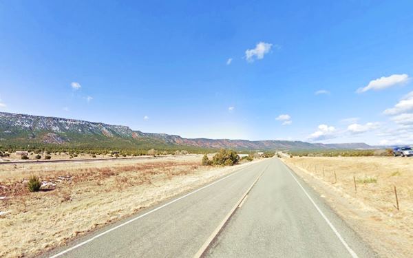
View of Ilfeld along the Old 1926 Route 66 - Ilfeld, New Mexico

The Santa Fe Trail linked this area with the communities of Pecos in the north and San Jose in the south. In the 1880s, the Atchison, Topeka and Santa Fe Railroad built the railway tracks beside the Trail, climbing up the Pecos River valley into the Rocky Mountains. In 1883 the railroad established a stop and called it Fulton.
A village grew around it and in 1926 when Route 66 was aligned through Fulton, the station changed its name to June, but it would not last for long. It soon became known as Ilfeld.
A post office named Ilfeld opened in 1929 (it closed in 1964).
In 1937 Route 66 was realigned further south, between Santa Rosa to Albuquerque bypassing all the towns along the Santa Fe Loop, including Ilfeld.
The name: Ilfeld
The name remembers a German pioneer of Jewish origin, Charles Ilfeld known as Tio (uncle) Carlos (18-1929). Who settled in Santa Fe in 1867 and built a trading emporium in Taos and also in Las Vegas.

Where to Stay near Ilfeld
There are plenty of accommodation options and lodging along Route 66 close to Ilfeld:
> > Book your hotel or motel in Santa Fe or Las Vegas NM.
More Lodging Near Ilfeld along Route 66
Below you will find a list some of the towns along Route 66 to the east and west of the village with hotels and accommodation; click on any of the links to find your hotel in these towns.
Heading West
- 36 mi. Santa Fe
- 94 mi. Albuquerque
- 148 mi. Acoma Pueblo
- 168 mi. Grants
- 228 mi. Gallup
Heading Main Route 66
- 69 mi.Moriarty
- 83 mi. Santa Rosa
- 141 mi. Tucumcari
West on The Santa Fe Route 66 segment
- 31 mi. Las Vegas New Mexico
Find your room nearby, in Santa Fe
Booking.com>> There are RV campgrounds near Ilfeld, in Las Vegas and Santa Fe
Weather in Ilfeld

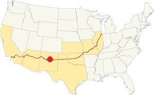
Location of Ilfeld on Route 66
The average high in summer (July) is 86°F (30°C) and the average low is 53°F (11.7°C). During winter (Jan) the average high is 48°C (8.9°C) and the average low is 21°F (-6.1°C), below freezing point.
Snowfall reaches 25 inches (63.5 in.) on average and can fall at any time between November and April. Most falling during Dec. and Jan (6 in. each). Rainfall is 17.2 in. per year (437 mm). The rainiest months are June through Sept. with almost 10 inches of rain.
Tornado risk
Ilfeld is located in an area with virtually no tornado risk: San Miguel county only has two (2) Tornado watches per year and mostly in the eastern fringe of the county.
Tornado Risk: read more about Tornado Risk along Route 66.
Map of Route 66 in Ilfeld, NM
The original Route 66 was aligned through Santa Fe in 1926 along three previous highways, the "Ozark Trail", the "Santa Fe Trail" and the "National Old Trails".

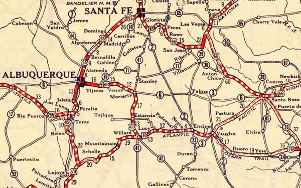
1925 Road map, Central NM
Click on image to enlarge.
Source
The thumbnail map above from 1925 (click on it to see the full sized map) shows the roads that existed one year before Route 66 was created.
Notice "Fulton" that later was renamed Ilfeld, between Rowe and San Jose.
Those marked "22" (National Old Trails Rd., coming from Los Angeles) and "32" (New Santa Fe Rd.) with white letters in a black box, went from Gallup to Albuquerque and through Santa Fe. Highway "50" was the Ozark Trails. Both "22" and "32" ran through Fulton.
The only paved sections (full black line) were between Albuquerque and Bernalillo, and Albuquerque and Tijeras. The highway from Bernalillo to Santa Fe, and beyond Isleta was "improved" (dashed line), the rest were either graded or dirt roads.
The Santa Fe Loop (1926 - 1937)
This was the first alignment of Route 66, from Santa Rosa to Albuquerque via Pecos (and Ilfeld) to Santa Fe.
We describe this segment in our Santa Fe Loop page, a dedicated webpage, with the full alignment, from Santa Rosa, through Dillia, Pecos, Santa Fe, Santo Domingo, and Bernalillo all the way to Albuquerque.
This original highway also continued beyond Albuquerque to Isleta, Peralta and Mesita.

1937 Realignment of Route 66
A political dispute between New Mexico Governor A. T. Hannett and local politicians led to the realignment of Route 66 in 1937.
Hannett blamed the local party bosses when he lost his 1927 bid to re-election. He decided to punish them, and their backers (the business men in Santa Fe) so he quickly had state highway #6 built, in 1927, to link Moriarty with Albuquerque. This highway bypassed the capital city, and was 90 miles shorter for those driving from the east to Albuquerque.
In 1937, the Federal roadbuilders decided to realign Route 66 using Hannett's road, and paved it. It was a straighter highway, and only had a short mountain segment across the Sandia Mountains between Sedillo, Tijeras and Carnuel.
Route 66 Alignment near Ilfeld
With maps and full information of the alignments of Rte. 66.
- Albuquerque to Lupton (next)
- Santa Rosa to Albuquerque 1937-85 (parallel)
- Tucumcari to Santa Rosa (previous)
The Santa Fe Loop (1926 - 1937)
Our Santa Fe Loop page describes the complete 1926 to 1937 alignment of Route 66 from Santa Rosa to Albuquerque through Pecos, Santa Fe and Bernalillo.
Ilfeld: its Attractions
Landmarks, Route 66 sights
The Historic Santa Fe Trail
The Spanish authorities of Colonial New Mexico scouted and opened the Santa Fe Trail in 1792 to link their capital city of Santa Fe, in the Spanish "Nueva Mexico" with the French trading posts on the Missouri River.
After the U.S. purchased Louisiana from France in 1803, the trailwas used by wagon trains used to move goods into New Mexico. It was also one of the routes chosen by the settlers used it to reach California and the Southwest.
The southern fork of the Trail passed through Las Vegas, Ilfeld, Pecos and crossed Glorieta Pass in the southern Rocky Mountains, just west of Ilfeld, to reach Santa Fe.
CanAm Highway
This "highway" has a total length of 1,975 mi (3,179 km) and is an international highway linking El Paso Texas with La Ronge in Saskatchewan, Canada. Hence its name "CanAm".
US Route 85 & I-25 are part of the CanAm highway, and both cross New Mexico, overlapping the old 1926 - 1937 alignment of Route 66 between Santa Fe and Romeroville, passing by Ilfeld.
End of this leg of your Road Trip
Here on the north side of Ilfeld is the end of this leg of your journey. Continue your road trip by heading north and visiting the next stop: Rowe along the original alignment of US66 in northern NM.

Some sponsored content
> > Book your Hotel in Santa Fe

Credits
Banner image: Hackberry General Store, Hackberry, California by Perla Eichenblat


