The Historic alignments Map
Route 66 Map 1926-1966 Jerome to Newburg MO
Map of US Highway 66 from Jerome to Newburg in Missouri.
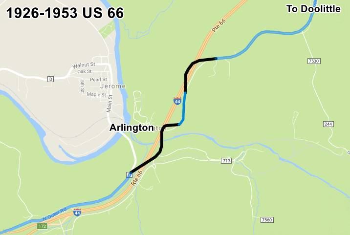
1. 1926 to 1953 alignment: two-lane Route 66
Pale Blue is the original 1926 to 1952 Route 66 that can still be driven. The Black segments have gone, either removed or buried under later roadbeds. It used the 1923 Bridge across the Little Piney River.
1926-1953 alignment of US 66 between Jerome and Newburg, Missouri
2. 1953 to 1966 alignment: four-lane Route 66
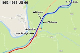
A completely new road with two eastbound lanes was built north from Powelville (Red) and on the south bank of the Little Piney River it was linked to the 1926 Route 66, using the 1923 bridge to cross the river. Then it followed the original alingment shown in Pale Blue, which was moved a bit to the east to make space for the two new lanes north of the river, this is now the Outer Road W.
At the northern tip of this alignment, at what is now Exit 176 the original alignment was bypassed (Red) and the four lane highway headed east into Rolla and is now under the roadbed of I-44.
The original highway south of Arlington became the westbound lanes of the new four-lane highway (Pale Blue) and a new bridge was built across the Piney River to carry it north, and then to the northeast, to Rolla (Blue).
1953-1966 alignment of US 66 between Jerome and Newburg, Missouri
3. 1966 - 1981 alignment
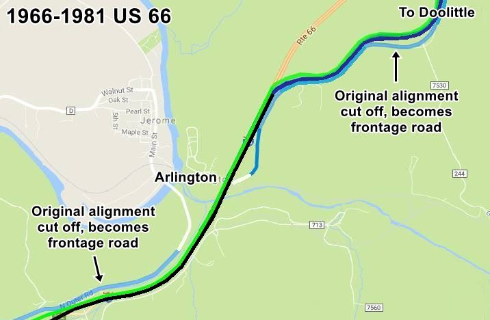
The old bridge was at the end of its life span so a new bridge was built to replace it and carry the eastbound lanes, the road in Arlington was straightened out (Black) and linked to the former westbound lanes (Blue). What is now Outer Rd. W, became a frontage road that only gave access to Arlington and the former eastbound lanes became the frontage road through Newburg to Exit 176 (Pale Blue).
A new set of westbound lanes were built cutting off the old ones, which became, south of Arlington through Jerome the N. Outer Rd., a frontage Rd. (Pale Blue). The new westbound lanes were far straighter and are shown in Green, they were carried over the Little Piney River by the 1953 bridge. North of the river they followed the former westbound lanes to the point where they turned east towards Newburg. From this point and east to Rolla two new lanes were added (Green) to the highway.
1966-1981 alignment of US 66 between Jerome and Newburg, Missouri
4. Later developments
Later in 2006, when Route 66 no longer existed, the whole of I-44 between Exit 176 and Arlington was realigned to the west of the older one. This bypassed the old segment through Newburg. The old 1966 bridge was replaced in 2009.
See Route 66's Complete alignment in Missouri Map
The Bridges across the Little Piney River and the Railroad
The St. Louis and San Francisco Railroad runs roughly parallel to the Little Piney River, from east to West coming from Newburg and going through Arlington. Route 66 cut both, at right angles, with a south to north course from Waynesville towards Rolla, here, at Arlington. So bridges had to carry the road over river and tracks:
1923 Railroad Bridge and the Little Piney River Bridge
This photo looking towards the northeast, shows the village of Arlington (lower left), the Single-span Pratt Through Truss bridge crossing the railroad (center - blue arrow) and (right - red arrow) the first span of the Five-span Pratt Through Truss bridge across the Little Piney River. You can see Route 66 curving in an "S" in the upper left part of the image.
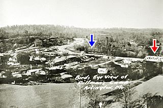
1923 Bridge at Arlington Missouri
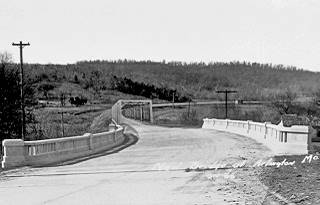
1932 Railroad Bridge
Looking west along Route 66. The 1923 Railroad bridge was replaced by a three-span concrete slab and steel beam bridge. Beyond it, the 5-span 1923 steel bridge over the Little Piney River remains untouched.
In the background, US 66 heads to the right into Jerome and Stony Dell.
1932 Bridge at Arlington Missouri
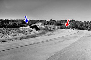
1953 Bridge
A new bridge was built to carry the westbound lanes across the Little Piney River, it was built to the west of the 1923 steel bridge, still in use. The photo looks east from Jerome towards Arlington. The older bridge would carry the eastbound traffic once the new one was completed.
Image credits: MODOT photo. Joe Sonderman Collection
1953 Bridge at Arlington Missouri
1966 Bridge
The 1966 addition of two new lanes led to the construction of a new bridge between the 1953 and the 1923 bridges. The old steel bridge from 1923 was demolished. This 1966 bridge in turn was replaced in 2009 but, by then, US 66 no longer existed.
The photos above and the information we used in this section come from the great book written by Jim Ross: Historic U.S. 66 Bridge Database 1926-1985, which is a state by state description of Route 66's bridges.
Sources
Jack DeVere Rittenhouse, (1946). A Guide Book to Highway 66.
Banner image: Hackberry General Store, Hackberry, Arizona by Perla Eichenblat.

