
Historic Route 66 in Luther OK
Index to this page

TheRoute-66.com is reader-supported. When you buy through links on our site, we may earn an affiliate commission at no additional cost to you.
About Luther, Oklahoma
Facts, Trivia and useful information
Elevation: 915 ft. (279 m). Population: 612 (2000).
Time zone: Central (CST): UTC minus 6 hours. Summer (DST) CDT (UTC-5).
Luther is just 28 miles east of Oklahoma City, on the eastern edge of Oklahoma County; it is a part of the Oklahoma City Metropolitan Area.
Threatt Filling Station

This area has been inhabited for at least 11,000 years. The Booher Site, listed in the National Register of Historic Places holds the remains of a Paleo-Indian camp site dating back 7,000 to 11,000 years ago.
The Native Americans that live here now are the outcome of the U.S. government's resettlement policy that began in around 1820 and relocated the Indians on the eastern side of the Mississippi River, in land located to the west of it.
Luther is on the land that was initially ceded to the Kickapoo group as a Reservation, but later re-purchased by the US government and "opened" to settlement through "Land Runs".
The Kickapoo originally lived in Illinois and were moved to Texas from where they were expelled. They relocated in the Indian Territory (which would later become Oklahoma). They were given their land and formed a reservation in 1883. However the Government then split the tribal land among the individual members to promote "assimilation" and purchased the surplus to allow settlement by people of European origin. The tribal government was disovled in 1898. But was reorganized in 1936. Today there are over 2,700 enrolled tribal members.
Land Run
A "Land Rush" or "Land Run" was a system by which those interested in staking a claim for a plot of land set off from a starting point and rode as fast as they could towards the land being "opended" to settlement. Once they reached it, they claimed their homestead on a "first come, first served basis". There were several "runs" in the early 1890s in Oklahoma.
The original town was planned under the name of Garnettville, in 1892. But only in 1898 did it begin to take shape: Luther F. Aldrich purchased the land from John A. Blizzard because the St. Louis and Oklahoma City Railroad, which later became the St. Louis and San Francisco Railway ("Frisco") would pass through it.
The town was platted in April 1898 and the post office opened in July 1898. Aldrich's partner, a wealthy Oklahoma City railroad businessman named Charles G. Jones suggested the name "Luther", after both his son "Luther" Jones and his partner.
A second railroad passed next to the town in 1903 and it was incorporated in 1905. By 1907, when Oklahoma became a state of the US, it had 423 residents.
Farming and cotton production were the main activity, it had five cotton gins by 1907 and soon avter the Historic Engels' Dry Goods Store opened (1910).
The Booker T. Washington High School for African Americans opened in Luther in 1916 and closed after the end of segregation in 1957.
Luther Trivia
One of Booker T. Washington High School for African Americans' graduates, Elizabeth Hilton-Threatt, was one of the first five African Americans to enroll at the University of Central Oklahoma. Her family owned the Threatt Filling Station
The Ozark Trail linked it to Tulsa and Oklahoma city and in 1926 it became part of Route 66 was aligned north of the town. It brought some prosperity during the years of the Great Depression which hit farmers badly. After World War II, the railways stopped serving Luther and, in 1953 the Turner Turnpike bypassed the town and drew away travelers to the safer and quicker Interstate highway.
Most of the local residents commute to work in neighboring towns.
Getting to Luther
Heading east from Luther down Route 66 are the towns of: Wellston (8 mi.), Warwick (12 mi.), Chandler (20 mi.), and Stroud (33 miles).
To the west, are Arcadia (8 mi.), Edmond (17 miles) and, Oklahoma City (28 mi.)

Hotels: Where to Stay
Book your hotel in the nearby towns of Chandler or Edmond
> > Book your Hotel in Chandler or in Edmond
More Lodging Near Luther along Route 66
Heading West
- 17 mi. Edmond
- 28 mi. Oklahoma City
- 43 mi. Yukon
- 57 mi. El Reno
>> There are some RV campgrounds close to Luther.
Luther’s Weather


Location of Luther on Route 66
During Summer, the temperature reaches average highs of 94°F - 34.5°C (July) and average lows of 71°F (21.5°C). The temperature during winter has highs (Jan) that average 48.5°F (9.2°C) and below-freezing average lows: 25.6°F (-3.5°C). Around 36 inches (914 mm) of rain fall every year, and the rainiest months are May, June and September with 5.5, 4 and 4.3 inches each (135, 100 and 109 mm).
There are approximately 89 wet days every year with thunderstorms more frequent during summer. Snow falls between November to March: 9.6 inches of snow (24 cm) per year.
Tornado risk
Luther is located in the "Tornado Alley and experiences approximately 10 Tornado watches annually
Tornado Risk: read more about Tornado Risk along Route66.
Map of Route 66 alignment through Luther
See this map of Route 66 through Luther. At Luther some sections of the original roadbed are gone, you can see them in our missing segments map (red lines).

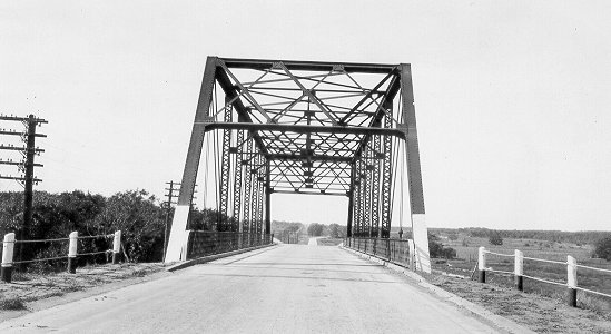
Old Steel bridge Route 66 over Frisco RR. Credits
The current highway curves slightly to the north on the eastern side of Luther because it was realigned in 1991 when the new railroad overpass was built to replace the original one (shown in the black and white photo).
But a short section of the original Route 66 still survives in the town, one block of N. Dogwood St., see it in this map.
It is pictured below, where (1) marks the dead end on the original 1926 alignment, (2) is the 1991 realignment and (3) the new overpass across the railroad.

Just 0.6 mi. west of the railroad, the original road turned right (now there is a takeout and store there), to cross the Deep Fork River. This section was bypassed in 1970. You can still see the old bridge abutements north of the modern bridge (pictured below).

Site and remains of old Bridge, click for street view

Old closed alignment West of Luther. Credits, click for street view
Further west, after the river, to your right, you can see the curved segment that heads eastwards to a dead end at Deep Fork River. This was the original 1926 road, paved in Portland cement in 1930 and bypassed in 1970 and pictured above, see it in this map.
The highway continues west, to Arcadia (map).
Route 66 Alignment near Luther
With maps plus complete information of the old roadway.
- Yukon to Clinton (next)
- Chandler to Yukon (Luther's)
- Tulsa to Chandler (previous)
Route 66 landmarks & attractions
Sights in Luther
- City tour in Luther, read more below
- Tours & Itineraries
Luther Attractions
In his 1946 book (A Guide Book to Highway 66), Jack DeVere Rittenhouse tells us what Luther was like just after the end of WWII.
The village lies south of US 66. The crossroad lies between two railroad overpasses. Only facility on US 66 is a gas station at the junction Rittenhouse (1946)
He added that there was "more gas" 4 miles west (the old Conoco). On the eastern side Rittenhouse mentioned that 3 miles away, was a "Gas station and Red Cross first aid station", which is the Threatt's Filling Station, and the town's cemetery with "old-fashioned markers".

1966 USGS map of Luther
Click on map to enlarge
The railroads he mentions are the current Frisco line and one that was removed, the Missouri-Kansas-Texas line, on the western side of the Deep Fork River, as you can see in the 1966 USGS map (click on thumbnail map to enlarge) marked with blue arrows. The highway follows the old alignment (now closed, mentioned further up). The red arrow marks the course US66 would follow when it was realigned in 1970.
Tour of Luther
We will start our tour on the eastern side of Luther, 3 miles east, at the historic Threatt filling station. This is the map of the tour.
Threatt Filling Station
On the SW corner of Route 66 and North Pottawatomi Rd. (that marks the Oklahoma County line), Luther, OK.

Threatt gas station Credits
Listed in the National Register of Historic Places
Vintage sandsone house-style service station built in the early 1900s on the main throughfare, that would later become Route 66.
The building dates back to the period between 1915 and 1920 and was built using local sandstone. As a service station it is designed in the "house style", with the appearance of a bungalow with a four gabled shingle roof. It remains unchanged (except for a 1961 shed added to the rear) and is exactly the way it was when Allen Threatt Sr. built it.
A grocery was added in 1935 and the café in 1937 named "The Junior".
Historic Threatt Filling Station near Luther (2021)

The pumps are gone and the place is closed and vacant. The Threatts were African Americans who had sought a new start as homesteaders in Luther, where they ran a farm and a small sandstone quarry. They later built and operated the Filling Station.
Initially it was located on the Ozark Trail that linked Oklahoma City with Tulsa. Later the Trail became State Highway No. 7 and in 1926 it was incorporated into the new U.S. Highway system as US Highway 66. This brought plenty of traffic and customers to Threatt's station. It was well located and became popular.
The difficult days for African Americans on Route 66
Nowadays it is hard to imagine that African American travelers were not welcome in many places, for instance, neighboring Edmond was a "Sundown Town", one of over 150 towns along US66.
But Threatt ran a gas station that catered to them, it was one of the few places where they were welcome. They could get food, fuel and even park on the premises to sleep overnight.
Head west, you will pass by the cemetery mentioned by Rittenhouse (to your right), see its street view.
Luther Junction Station (gone)
At the access into Luther from Route 66, turn left onto North Dogwood St. Here, at one time stood the "only facility" mentioned by Rittenhouse, the gas station was torn down as it lay in the way of the 1991 realignment that replaced the old steel railroad overpass, you can see it, and the bridge (red arrow) in the image below, looking west along US66.

Old Junction station and bridge, credits

Luther Junction station and bus stop. Credits
The photo above, taken in 1977, shows the old station, built in 1921 from the Oklahoma Times newspaper was captioned "The Luther bus junction sits as it has for 56 years, waiting for the bus to stop on its daily schedule." The station was the one mentioned by Rittenhouse, notice the Greyhound sign hanging under the canopy.
Drive into the town by heading south along Dogwood.
Luther Town gas station
On the SE corner of E 1st St and Main St. this is a 1920s filling station built in yellow bricks, with two solid pillars supporting the canopy. The building faces the corner and is angled; it has two service bays on the North side of the property.

Halfway down the block, along Main is the historic store. To the right of the Police precinct.
Engels' Dry Goods Store
112 S Main, Luther, OK.
Listed in the National Register of Historic Places
A typical American store of the early 1900s on the town's Main Street. Michael C. Engels opened the dry goods store in Luther in 1915, he moved across the road to its current location in 1921.
Besides dry goods he also sold food and drink. Engels was a pioneer who came to the Indian Territories in 1889.
The one-story building is built in brick and has a recessed central entry. The building was purchased by the town and was renovated. Now it houses a store.
Engels' Dry Store, Luther before restoration (2014)

Engels' Dry Store, Luther restored (2021)

Your City Tour ends here, drive west to visit the historic marker and the old Conoco ruins.
Tours & Itineraries
Head west along Route 66, 3.4 mi from Luther, to your left is the historic marker.
Run of '89 Marker
The pink granite marker (street view) reads "Run of '89 East Boundary - At the opening of old Oklahoma April 22, 1889, this was the east line for the Run starting at 12 o'clock noon. Prairies and hills in the 2,000,000 acre tract west were people by tens of thousands. Homes were planted and tent cities sprang up before nightfall".
Continue west for 1.5 miles and visit the ruins of the Conoco gas station.
Ruins of Conoco Service Station
To your right, on the north side of the road are the remains of a service station that once catered to travelers driving down Route 66.
Ruins of Luther's Conoco Service Station


The limestone blocks of a roofless shell correspond to a Conoco filling station built sometime between 1915 and 1920. There is a sign telling its story, which involves counterfeiting and gangsters.
Apparently the owner printed fake $10 bills in the back of the shop. Eventually he was caught and jailed. The station closed and fell into ruin. Later in the 1940s a body was found there, a murder victim, who was never identified.
You can now head west and drive on, into Arcadia and continue your Road Trip.
Some sponsored content
> > Book your Hotel in Edmond
Credits
Banner image: Hackberry General Store, Hackberry, Arizona by Perla Eichenblat
Jack DeVere Rittenhouse, (1946). A Guide Book to Highway 66
Town website www.townoflutherok.com
Threatt Filling Station, National Park Service
Threatt Station Historic Place Register form
The Threatt Filling Station Foundation