Route 66 in Mesita NM
Index to this page

TheRoute-66.com is reader-supported. When you buy through links on our site, we may earn an affiliate commission at no additional cost to you.
About Mesita, New Mexico
Facts, Trivia and useful information
Elevation: 5,669 ft (1,728 m). Population: 1,214 (2023).
Time zone: Mountain (MST): UTC minus 7 hours. Summer (DST) MDT (UTC-6).
Mesita is a small village located on Route 66 in Cibola county, NM.
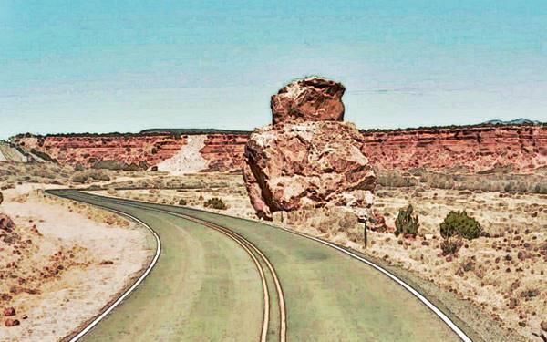
Owl Rock next to Route 66 in Mesita, NM
The archaeological site of Sandia Cave shows that New Mexico has been inhabited for the last ten thousand years. In more recent times, the Native American people have lived in the valleys of the rivers that flow from the Rocky Mountains into the Rio Grande Basin, using the water to irrigate their crops of maize, squash and beans.
The first Europeans to visit this region were the Spanish of Francisco Vásquez de Coronado's expedition in 1540. They visited the nearby Acoma Pueblo. Later, when they finally annexed the area to their American Colonies in 1598, they subdued the Pueblo people by force and established missions to convert them to Catholicism. The Pueblo people expelled the Spaniards in 1680 (Pueblo Revolt), but they were defeated and reconquered in 1692.
The nearby Indian pueblo of Laguna was established in 1697. In 1821, after Mexico gained its independence from Spain it took possession of New Mexico, but ceded it to the U.S. after being defeated in the Mexican - American War (1846-48).
Mesita was established on the south bank of the San Jose River (also known as Cubero River), a tributary of the Rio Puerco in the 1870s by a faction that split from the Laguna Pueblo people.
The split was due to the growth of Protestant Christianity in the area after the arrival of the Baptists in 1850 and the Presbyterians in the 1870s.
The town's Native name is "Tsé Ch' ééhii", which means "Red Rocks Pointing out horizontally".
In the 1880s the Atchison, Topeka and Santa Fe Railroad reached the area and extended its tracks from Albuquerque towards Gallup. Its station was named "El Rito".
Origin of the name Mesita
The word is Spanish and means "Small Mesa". A "Mesa" is a plateau (the word means "Table" in Spanish).
Rito is a colloquial Spanish word used in New Mexico as a short form for "tiny river" (riito, diminutive of r&iaute;o -river), and basically means "Sping" don't confuse with the correct meaning for rito whic is "rite" (as in ceremony).
The San Jose River was once known as "Arroyo del Rito" or "Spring Stream". And the ranch at El Rito was known as "El Riito del Pino" (Spring of the pine tree).
In 1926, Route 66 was aligned along the "Old National Trails" which linked Gallup, Laguna and Mesita with Los Lunas and Albuquerque. It remained on the alignment and even today the old US 66 can be driven on, close to the town. Interstate 40 was built just to the west of Route 66 and you can access the town from Exit 117.
To the east of Mesita is the San Jose River and behind the river rises the Mesa Gigante.

Where to Stay: Hotels in Mesita
Neighboring Albuquerque has plenty of lodging options for those driving along Route 66, you can book a hotel or motel in town:
>> Book your Hotel in neighboring Albuquerque or in Acoma Pueblo
More Lodging Near Mesita along Route 66
Below is a list some of the towns along Route 66 east and west of Mesita, click on any of the links to find your hotel in each of these towns.
Heading West in NM and AZ
- 17 mi. Acoma Pueblo
- 37 mi. Grants
- 97 mi. Gallup
- 149 mi. Chambers
- 195 mi. Holbrook
- 241 mi. Winslow
- 263 mi. Twin Arrows
- 287 mi. Flagstaff
Heading East
- 45 mi. Albuquerque
- 84 mi. Moriarty
- 161 mi. Santa Rosa
- 218 mi. Tucumcari
- 298 mi. Vega, TX
- 335 mi. Amarillo, TX
- 430 mi. Shamrock, TX
- 469 mi. Sayre, OK
The Santa Fe Route 66 segment
- 104 mi. Santa Fe
- 163 mi. Las Vegas NM
Find your room in neighboring Albuquerque
Booking.com>> There are RV campgrounds near Mesita in Paraje
The weather in Mesita
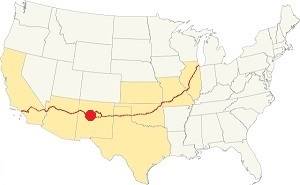
Location of Mesita on Route 66
Mesita is located just west of the Rio Grande Valley. Its climate is dry and sunny (278 sunny days per year) with a low relative humidity. There are large swings between day and night temperatures, even in summer.
Average High ⁄ Low Temperatures during summer (Jul.) are: 92 ⁄ and 65 °F (33 ⁄ 18 °C) respectively. The average high and low in winter (Jan) are about: 47 ⁄ and 24 °F (8 ⁄ -4 °C)
Summers are hot and winters are cold. Rainfall falls mostly during the summer monsoon season (July through September), and adds up to about 11 in. per year (279 mm). Snowfall is quite low: around 10 inches (25 cm) per year.
Tornado risk
The tornado risk in Mesita is nil: Cibola County has no Tornado watches. The area west of this point has no tornado events.
Tornado Risk: read more about Tornado Risk along Route 66.
Map U.S. 66 in Mesita New Mexico
Into Mesita along Route 66
This is the Map from Suwanee to Mesita. It carried Route 66 from 1926 until the 1950s when a four lane upgrade was built where I-40 is now located. The western tip of this segment meets I-40 on the south side of Mesita at where Sparrow Hawk Rd crosses it. After this point, the original 1926 alignment it is overlaid by the freeway (blue line in our custom map). The highway passes beside the western side of the village of Mesita.
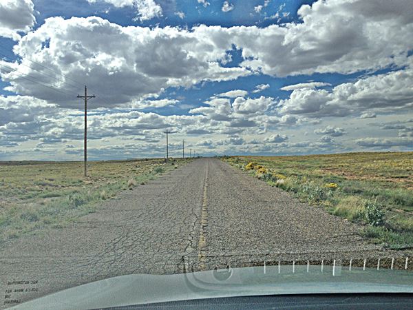
The original roadbed: Route 66 just west of Suwanee, NM heading towards Mesita:
Owl Rock
You will have to take Exit 117 to cross to the northeastern side of the Freeway to continue your journey. Ahead, 1.7 mi. west of Mesita along Old Route 66 (see this Map and directions) is Owl Rock; we describe it further down. It is a rock formation on the eastern side of the road that actually looks like an owl.
1926 to 40s alignment
Keep on along Route 66 for another 0.7 mi. and drive the "deadly" Dead Man's Curve described furhter down where the road curves 270° around a cliff. It is 2.4 mi. west of Mesita along Old Route 66 (see this Map marking the spot).
1932 to 1985 Route 66
Due to the dangers of Dead Man's Curve, a new straighter alignment was built in 1932. It was described by Rittenhouse in 1946 and you can see it in this 1951 aerial photo), we marked it with a yellow line in our custom map. It runs in a staight line from Owl Rock to Laguna.
This is the older 1926-40s alignment map with the road from Mesita into Laguna including Owl Rock and Dead Man's Curve. Both alignments meet at Laguna next to Exit 114 in Laguna.
Route 66 Alignment near Mesita
With maps and full information of the old roadway.
- Lupton to Winslow (next)
- Albuquerque to Lupton (Mesita's)
- Santa Rosa to Albuquerque (previous)
The Santa Fe Loop (1926 - 1937)
Our Santa Fe Loop page describes the complete 1926 to 1937 alignment of Route 66 from Santa Rosa to Albuquerque through Pecos, Santa Fe and Bernalillo.
Mesita: its Attractions
Mesita: Owl Rock, Dead Man's Curve
Historic Context
Jack Rittenhouse in his 1946 classic Guidebook to Route 66, mentioned Mesita as follows:
... the highway enters upon an area of richly colored desert and mesa... you will notice MESITA VILLAGE off to the right. This cluster of homes is not on US 66 and has no facilities for the traveler... The countryside looks much as it did in the days when Coronado wandered through here seeking the fabled cities of gold. Rittenhouse (1946)
We will cross the town from east to west. Drive west from Suwanee along the 1926-50s Route 66, cross the freeway to its north side using the overpass at Sparrow Hawk Rd. Ahead at Mesita Rd., to your right is the access to the small village. Head west along the Frontage Rd.
Owl Rock
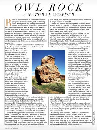
The article about Owl Rock in Route magazine
Remarkable Natural Formation
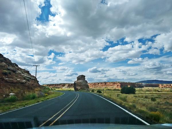
This rock is located 1.7 mi. west of Mesita along Old Route 66 (see this Map and directions).
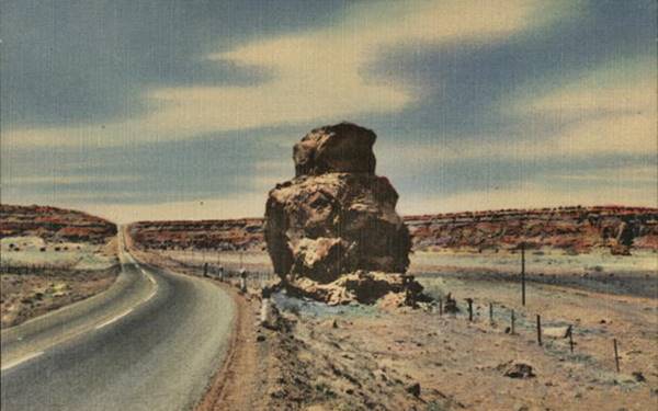
It is a 20 foot tall sandstone formation on the eastern side of the road (right side heading from Mesita towards Laguna), that looks like an owl.
We were interviewed for an article, Owl Rock a Natural Wonder, published on page 39 of the Feb-Mar 2021 issue of Route magazine. In the article I mentioned that there were only two animal-shaped natural rock formations close to Route 66, on its shoulder. Both were located in New Mexico. This one has survived, the other in Carnuel was taken down (Elephant Rock).
Below is a 1940s postcard describing it as "Owl Rock on Highway U.S. 66 About 40 Miles West of Albuquerque, N. Mex."
It is part of the same rock formation to the west, and it seems that the highway was aligned right by it on purpose. Below is a picture we took in 2016, driving west:
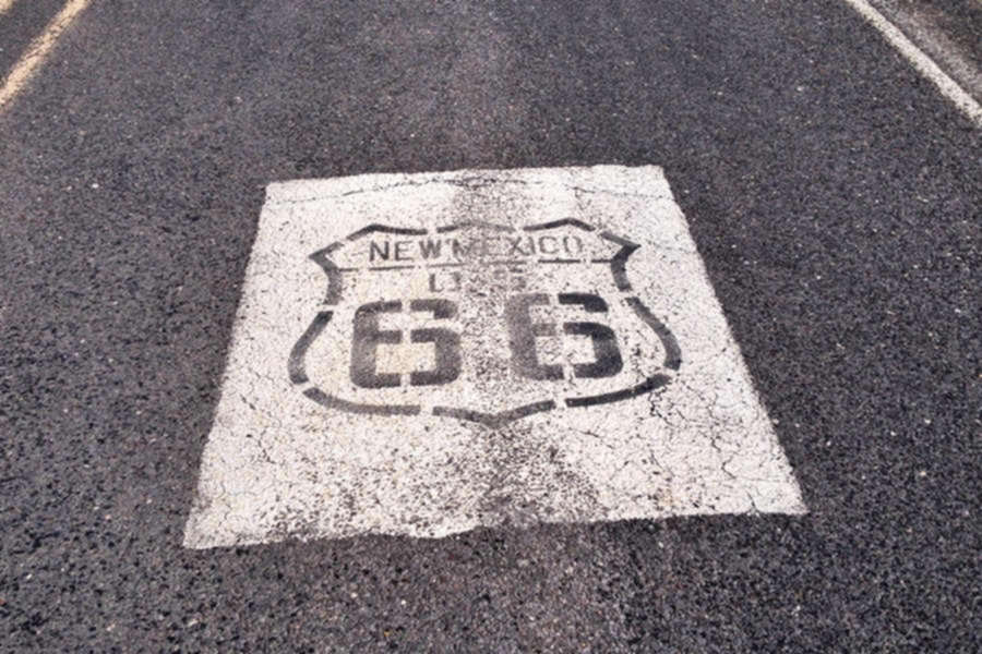
US 66 Shields painted on the Roadway
Just ahead you will see the U.S. 66 shields painted on the highway see map, ´pictured below.
This one is just past the "Dead Man's curve" between Mesita and Laguna, New Mexico
> > Learn more about the Shields Painted on Route 66
Fork in the alignments
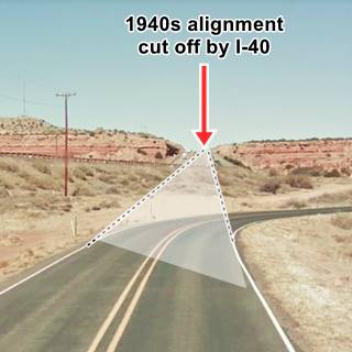
Here the 1926-32 highway curves to the west and the later and straighter 1932-1985 road continued with a SE to NW course as shown in our custom map with a yellow line.
This road avoided the dangerous Dead Mans curve just ahead but, as Rittenhouse in 1946 mentioned, three miles west of Mesita there was a "short, steep hill going up west here, in a cut through a mesa." You can see this road in the postcard further up and in the image below. Now I-40's westbound lanes run where the old roadbed was.
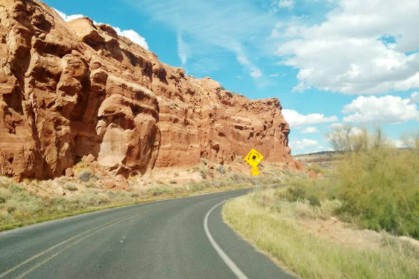
Dead Man's Curve
The narrow canyon of the river is closed in by red colored sandstone bluffs, and the road runs between the cliff and the river. There are great views of the red sandstone rocks on the sheer walls of the mesa.
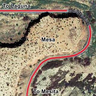
At the northern tip of the mesa the river curves sharply around it, and so does the old Route 66; it takes a long curve around a mesa switching its south-to-north direction for an east-to-west one, and does so by following a circular curve that spans 270° as can be seen in the image above.
It was a much cheaper option for roadbuilders than cutting through the sandstone. But, as the curve's name shows, a not very safe option for unwary drivers.
The "deadly" Dead Man's Curve is 0.7 miles west of Owl Rock, and 2.4 mi. west of Mesita along Old Route 66 (see this Map with directions).
Dead Man's Curve between Mesita and Laguna
Continue your Road Trip
Your Route 66 itinerary through Mesita ends here. You can continue your Route 66 road trip by heading west into the next town, Laguna NM.

Sponsored Content
>> Book your Hotel in Albuquerque


Credits
Banner image: Hackberry General Store, Hackberry, Arizona by Perla Eichenblat
Jack DeVere Rittenhouse, (1946). A Guide Book to Highway 66.


