Your Route 66 Road Trip in Morgan Heights
Index to this page
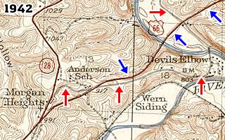
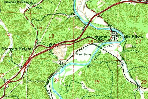
USGS Map from 1942 showing Morgan Heights MO and Route 66.
Red arrows mark the 1926-43 alignment of US 66. Blue ones the later roadway.
- About Morgan Heights
- Weather
- Hotels close to Morgan Heights
- Map of US 66
- What to see and do in Morgan Heights

TheRoute-66.com is reader-supported. When you buy through links on our site, we may earn an affiliate commission at no additional cost to you.
About Morgan Heights Missouri
Facts, Trivia and useful information
Elevation: 1,012 ft (309 m). Population n⁄a (2010).
Time zone: Central (CST): UTC minus 6 hours. Summer (DST) CDT (UTC-5).
Morgan Heights is located on the 1926-1943 alignment of Route 66 in Pulaski County, central Missouri.
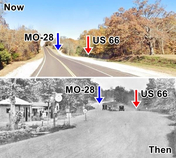
The image below shows a current street view (Top) of the point where the 1926 to 1942 alignment of Route 66 curves to the right, leaving the old MO-17 highway and a c.1930s6 view of that same spot (Bottom), with the old cabins and filling station, razed to make way for the modern paved highway.
The 1926-1943 Route 66 then and now in Morgan Heights, Missouri
History of Morgan Heights
For the general history of the area check the History of Waynesville.
The "Wire Road" built during the 1860s to service the telegraph line from St. Louis to Fort Smith in Arkansas, passed through Morgan Heights, and would become the main road from St. Louis to Springfield and would become State Hwy. 14 in the early 1920s and U.S. 66 in 1926. Later in 1943 Route 66 was upgraded to a four-lane freeway with a straight alignment that bypassed the hamlet, causing its demise.
The name: Morgan Heights
Named after its hotel.

Where to Lodge near Morgan Heights, Missouri
Accommodation and hotels close to Morgan Heights, neighboring St. Robert has many hotels and motels.
> > Book your hotel in St. Robert
More Lodging near Morgan Heights along Route 66
The towns along Route 66 also have plenty of hotels. Click on the links below to find a room in any of those towns.
Hotels Westwards, MO, KS, OK
- 3 mi. St. Robert
- 7 mi. Waynesville
- 40 mi. Lebanon
- 70 mi. Marshfield
- 82 mi. Strafford
- 95 mi. Springfield
- 155 mi. Carthage
- 172 mi. Joplin
- 188 mi. Baxter Springs
- 204 mi. Miami
- 219 mi. Afton
- 234 mi. Vinita
- 268 mi. Claremore
- 291 mi. Catoosa
- 294 mi. Tulsa
Accommodation eastwards in Missouri
- 22 mi. Rolla
- 33 mi. Saint James
- 47 mi. Cuba
- 65 mi. Sullivan
- 80 mi. Saint Clair
- 92 mi. Villa Ridge
- 99 mi. Pacific
- 109 mi. Eureka
- 126 mi. St. Louis
Hotels further East, in Illinois
- 131 mi. East St. Louis
- 138 mi. Granite City
- 140 mi. Pontoon Beach
- 147 mi. Glen Carbon
- 148 mi. Troy
Book your Hotel in neighboring St Robert
Booking.com>> Check out the RV campground in neighboring Waynesville
Weather in Morgan Heights

Location of Morgan Heights on U.S. Hwy. 66
Morgan Heights has well defined sesons: During summer, the average high (Jul) is 88°F (31.2°C), and the average low in 67°F (19.2°C). During winter (Jan) the average high is 42°F (5.6°C) and the average low is below freezing at 20°F (-7°C).
Rainfall averages 44.5 in (1.131 mm) per year and falls regularly each month in roughly the same amount). Snowfall is about 9 in. (23 cm), and falls between Dec. and Mar.
Tornado risk
Morgan Heights is located inside Missouri's "Tornado Alley" and Pulaski County is hit by some 8 tornado strikes every year.
Tornado Risk on Route 66:read more about Tornado Risk along Route66.
Map of Route 66 through Morgan Heights
Old Route 66: 1926-1943 Alignment in Morgan Heights
The 1926 to 42 Route 66 reached Morgan Heights coming from Devil's Elbow along Teardrop Rd. (map). It was made safer during WWII when a straighter four-lane highway was built. See it in this 1943-1977 Map.
The WWII alignment became part of I-44, and the freeway remained on it even after US 66 was decertified in 1977. This roadbed was later bypassed in 1981 by a newer alignment of I-44 which cut through a section of the old 1926-43 Route 66 roadbed (marked with the Black line on the right side of the map).

Route 66 map, Morgan Heights
The 1926-43 US 66 section on the north side of the freeway is there, but the part to the east of MO-28 can't be driven. See this map showing the location of the now cut off alignment in Morgan Heights. The map shows the alignment in Blue and the Black lines mark the spots where the modern freeway cuts the old road. The segment that can still be driven on the north side of the freeway is now MO-28, and you cans see it in this map.
WWII realignment West of Morgan Heights
At Grandview next to Morgan Heights, the new 4-lane US66 kept straight and bypassed the old curved segment through Morgan Heights. The new alignment is shown in Pale Blue in the map.
West of Morgan Heights the four lanes continued, but they were not close to each other. The eastbound lanes followed the original 1926 Alignment which now is Hwy Z. The westbound lanes were new; a straight alignment which is now under I-44, running all the way to Hardy Ln. where all four lanes met and again ran as a divided highway into Ft. Leonard junction with Route 66.
This is the map of the 1926-43 Route 66 into St. Robert.
Further down we describe the alignments in detail.
The Route 66 alignment in Morgan Heights
Visit our pages, with old maps and plenty of information about US 66's alignments.
- Springfield to Joplin (next)
- Rolla to Springfield (in Morgan Heights)
- Gray Summit to Rolla (previous)
Route 66 Sights in Morgan Heights
Landmarks and Places to See
Historic context, the classic Route 66 in Morgan Heights
Jack DeVere Rittenhouse published his "A Guide Book to Highway 66" in 1946, but by then Morgan Heights had already been bypassed by the newer four-lane highway, so he did not mention it.
Route 66 Road Trip: Morgan Heights segment
As usual we will drive east to west. Coming from Devil’s Elbow and heading towards St. Robert.
The original 1926-43 alignment ran along what is now known as Teardrop Rd., then the four-lane highway was built (bypassing Devil's Elbow) to the north. Both alignments meet on the eastern side of Morgan Heights.
The follwing maps show how Route 66 evolved over the course of the years.
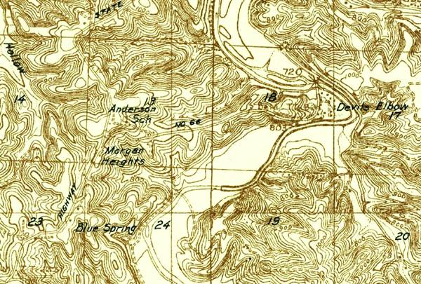
The map above (published in 1936) shows the highway curve around Morgan Heights (running in an arch south of Anderson School), then it takes a NW-SE course.
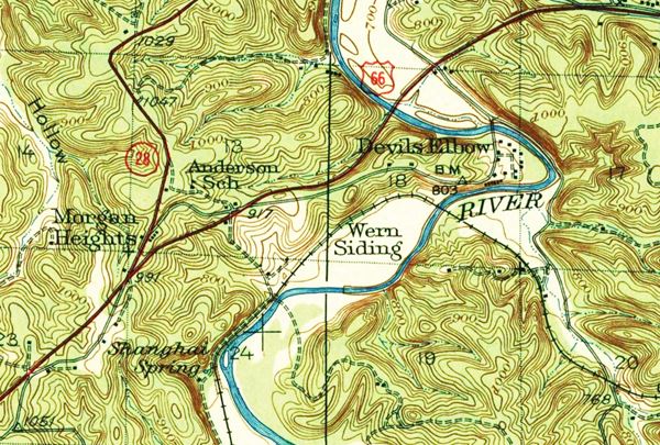
The map below (from 1842) shows the new alignment (red line) that bypassed Devil's Elbow and Morgan Heights. It also is straighter. It meets MO-28 at Morgan Heights.
The four lanes were not all built in one go. By 1954 a new junction was built on the eastern side of Morgan Heights, where Teardrop Rd. met the new alignment.
Eastern side of Morgan Heights. Grandview
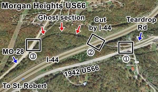
The aerial view below shows our tour across Morgan Heights from east to west (right to left). I-44 cuts across the image from the upper right corner to the lower left. Slicing the original Route 66 roadbed. There is a "Ghost section" (red arrows) on the north side of the freeway in Morgan Heights. The blue arrows mark the two sections that can still be driven; Teardrop Rd. to the east and MO-28 to the west. Beneath the freeway is the four-lane highway that was built in 1942. The rectangles numbered 1, 2, and 3 correspond to images shown further down in the text.
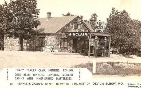
Ernie and Zada’s Inn or E-Z Inn
See this map with the itinerary on the eastern side of the freeway in Morgan Heights.
Coming from the east, 0.1 mi before you reach US Route 66, to your right, at 21755 Teardrop Road (Location Map), is the site of an old motel.
The postcards from the 1930s announced that it was "1 mile West of Devil's Elbow" and offered "Dancing, fishing, hunting, shady trailer camp, dinners, lunches, beer, modern cabins with In-Spr. Mattress."
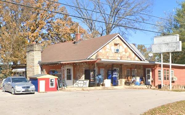
Ernie and Zada opened the complex in 1932, and named it "EZ Inn" combining their name's initials. But it closed a few years later. In the 1950s the property changed hands and was renamed Oak Park Cabins. 20 years later became known as Grandview Apartments or Grandview Courts. There was a Sinclair gas station which still stands and the old canopy has been closed in. The cabins were torn down in 2010. Below is a "Then and Now" set if pictures.
Just ahead the 1926-43 Route 66 meets the four-lane Route 66 divided highway built to replace it. Cross it and take a left along Teardrop Rd. on its north side, here to your right is a 1950s motel.
Devil’s Elbow Motel
At 21815 Teardrop Rd. The motel building is still there, in poor shape. The McClary family built it in 1950 with eleven units and a "L" shaped layout. The gable-roof building to the left was the office.

Vintage postcard of the Devil’s Elbow Motel,Credits
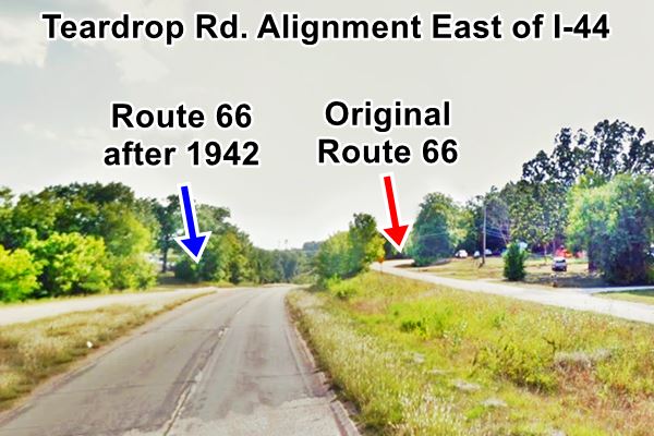
Teardrop Rd. cut off by I-44
Teardrop road climbs and curves to the right (red arrow), and is cut off by I-44. It continues as the "Ghost Section" on the north side of the freeway.
The blue arrow marks the four-lane Route 66 used from 1943 to the 80s.
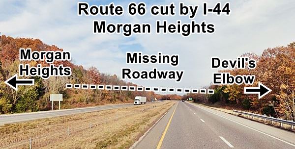
Route 66 cut by the Freeway
Below is a view on the freeway, showing the original alingment (dashed line) of Route 66. The interstate cut the old alignment and lies in a cutting across a low hummock.
Route 66 in Morgan Heights proper
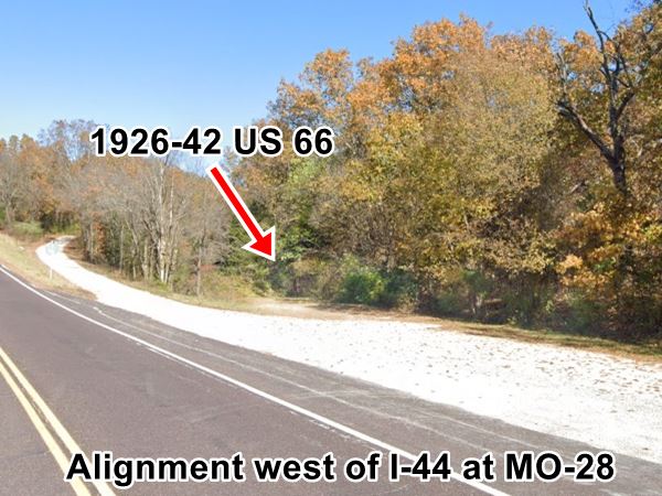
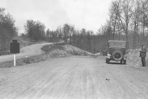
Now head to the north side of I-44 (map with directions) using the overpass at Exit 163 and driving east along MO-28, the road runs on the north side of the freeway and then turns to the north. Just ahead, to your right there is a triple fork in the road: the old alignment (1926 to 1943) is the easternmost road to the right (red arrow), then comes the former MO-28, now Holly Dr. and next to it, on the left, the paved current alignment of MO-28.
Same view in the 1920s, Route 66 (right), MO-28 (left)
Morgan Heights a vanished village
It was here that Missouri State Highway 28 and MO-14 (that in 1926 became Route 66) took different courses; the former went north to Dixon, the latter east to Devil's Elbow along the now closed "Ghost Section."
The "Morgan Heights Cafe" and "Tourist Hotel and Cabins" stood there, with a Texaco gas station.
See the "Then & Now" photo at the top of this page, where we combine the current street view with an old postcard. The buildings were later demolished when MO-28 was paved and straightened out.
Morgan Heights Cafe on Route 66 (now MO-28)

The sign on the two-story building reads "Morgan Heights Cafe Hotel Tourist Cabins" there is a Texaco sign, and four people standing in front of the hotel and behind the three gas pumps. The cabins are on the right side of the image.
It was also a and a Pickwick Stages Bus Line stop. In 1929 Pickwick merged into Northland Transportation and became Pickwick Greyhound, a national intercity bus company. Greyhound was the creation of Carl Eric Wickman, Swedish-born entrepreneur who after being laid off from his job in a mine in 1914 began a bus line.
Ghost Section

Original roadbed in the "Ghost Section."
See original large size image
The road that forks off to the left and curves back to I-44 is the original alignment of Route 66. You can see it clearly in this 1955 aerial view that shows the intersection of the four-lane highway with old Route 66 on Teardrop Rd., and further east how the four-lane alignment was actually two separate roads, one following the original Route 66 in a meandering path, the other with a straight course (westbound lanes). Also notice that modern I-44 didn't exist at that time.
Nearby attractions
The WPA's 1941 guide to Missouri, mentioned the area around Morgan Heights, and some local attractions.
... junction with State 28, a graveled road. Right here to a junction with an unmarked graveled road, 2.2. mi., which leads R. 0.9 m. to the entrance of Possum Lodge, a long-established fishing camp. Near by is a wagon ford used by pioneers. Many legends are connected with the site. One story tells of a wealthy Forty-niner who became ill at the ford on his way back East, and buried gold worth $60,000 in the near-by hills... At 3.7 m (R) on State 28 is a good view of the narrow valley of the Gasconade River. WPA Guide to the "Show Me" state (1941)
This map shows the approximate location of the old "Possum Lodge", and the "good view of Gasconade River" can be seen in this street view.
This marks the end of your short drive through Morgan Heights, continue west to visit St. Robert on the next leg of your Route 66 road trip.

Some sponsored content
> > Book your hotel in Lebanon


Credits
Banner image: Hackberry General Store, Hackberry, Arizona by Perla Eichenblat
Jack DeVere Rittenhouse, (1946). A Guide Book to Highway 66
Missouri: The WPA Guide to the "Show Me" State (1941)
Architectural - Historic Survey of Route 66 in Missouri and Detailed Survey, Maura Johnson. 1993


