Route 66 in Narcissa
Index to this page

TheRoute-66.com is reader-supported. When you buy through links on our site, we may earn an affiliate commission at no additional cost to you.
About Narcissa, Oklahoma
Facts, Trivia and useful information
Elevation: 843 ft. (257 m). Population: 100 (2010 census).
Time zone: Central (CST): UTC minus 6 hours. Summer (DST) CDT (UTC-5).
A small village just south of Miami, in northeastern Oklahoma, close to Kansas and Missouri.
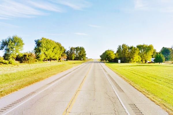
Narcissa, looking north along Route 66
Narcissa's History
See Miami, History for full information on the region's history.
Percy Ladd Walker was born in Kansas City in 1849 and he was appointed Federal Postmaster in the Indian Territory which would later become the State of Oklahoma, in 1893.
He was one-fourth Wyandotte Indian, but was adopted by the Cherokee Tribe, he served as a member on the Tribal Council.
Walker moved with his wife Mary Mahaney Audrain to what would become Ottawa County in 1868, and by 1885 was well established in what would later become Narcissa.
After 1893 his office was located in Prairie City, close to Fairland OK. His grave is in Fairland (he passed away in 1940).
Narcissa, the name
The Percy and Mary had five children and they named one of their daughters, born in 1879, Narcissa Owen Walker. The town was named after her.
It is of Greek origin and means "daffodil", it is the feminine form of Narcissus, the Greek youth who was enthralled by his own reflection, and the origin of the word "narcissism".
In the days when Oklahoma was a Territory, prior to becoming a State, this area was the Cherokee Nation. Walker opened a post office opened there on January 15, 1902 (it closed in 1916).
Narcissa was incorporated in 1902 just one year after the Frisco Railroad passed through the region. The Gaines brothers built a grain elevator in what would become the center of the small hamlet. Soon stores opened and a school was built.
Route 66 brought travelers and revenue to the town, one of the Gaines would open a Gas station on the road.
In his 1946 guidebook (A Guidebook to Highway 66), Jack D. Rittenhouse described the town as follows: "Only one establishment on US 66: a gas station with a grocery and a small garage." He noted that Narcissa had about 25 homes, a school and the grain elevator.
Route 66 would become overcrowded and therefore perilous so when the Turner and the Will Rogers Turnpikes linked Oklahoma City and Joplin, Missouri in 1957, the multi-lane highway bypassed the old segments of Route 66, in Ottawa County. Business decreased and the town gradually grew smaller.
Where to Stay
There are several hotels in neighboring Miami. Alternatively you can also lodge in the neighboring towns in Kansas, Missouri and Oklahoma.
> > Book your Hotel nearby, in Miami (6.5 mi)
More accommodation along Route 66
Heading West
Heading East
- 7 mi. Miami
- 23 mi. Baxter Springs, Kansas
- 26 mi. Riverton
- 39 mi. Joplin
- 58 mi. Carthage
>> There are two RV campgrounds close to Narcissa.
Weather in Narcissa

Location of Narcissa on Route 66
Check the Weather and climate of Miami for historical weather information.
Tornados
Tornado Risk: Narcissa lies within the "Tornado Alley in Oklahoma and experiences about 9 Tornado watches every year.
Read more about: Tornadoes on Route66.
Map of Route 66 through Narcissa
Below is a map published in 1924. It shows the "Auto Trails" in northeastern Oklahoma. Narcissa is on the upper right corner, beneath Miami. The auto trails were highways that were suitable to be driven with cars mostly dirt surfaced roads. Trail #50 going through Narcissa was the "Ozark Trail", notice how it bypassed Afton on its way to Vinita.
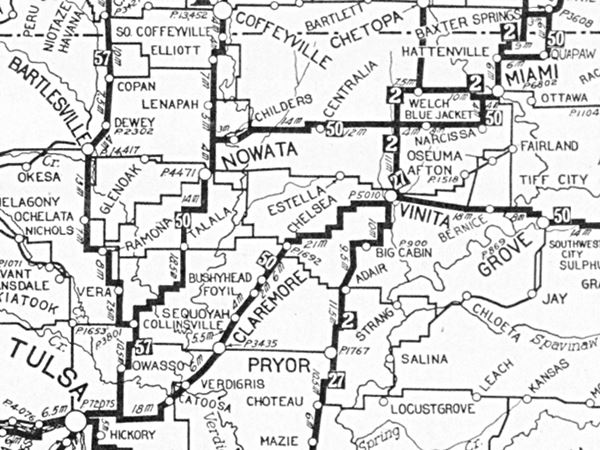
Route 66 was created in 1926, and the map below shows (red arrow) where Narcissa is located. US66 overlapped Oklahoma State Higway #7 along the "Ribbon Road". This map also shows US 66 bypassing Afton. Instead it heads west, meets US 73 and then runs south into Vinita.
1927 Map showing the Historic Ribbon Road, US 66 in Oklahoma
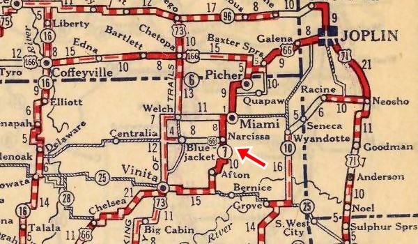
David Rumsey Historical Map Collection
Map of the Ribbon Road
The thumbnail map (click it to enlarge) shows the alignment of the Ribbon Road from Miami to Narcissa, in orange. The pale blue line marks the later (1935) Route 66 alignment. (Narcissa is in on the lower left side).
See this Map with directions of the Ribbon Road to Narcissa.
Narcissa
The Original alginment and later one meet at Narcissa. And from here head south towards Afton where there is a "southern" part of the Ribbon Road.
Route 66 Alignment near Narcissa
Visit our pages with old maps and plenty of information of the old US 66 roadway.
- Vinita to Tulsa (next)
- KS-OK state line to Vinita (Narcissa's)
- Ribbon Road or Sidewalk Road. (original road)
- Route 66 in Kansas (previous)
Route 66 landmarks & attractions
Sights in Narcissa
In his "Guidebook to US Highway 66" published in 1946, Jack Rittenhouse describes Narcissa.
NARCISSA. Only one establishment on US 66: a gas station with a grocery and small garage. Rittenhouse (1946)
He mentions that the town has 25 homes, a grain elevator and a school. It still is a small village with 126 residents. The grain elevator has gone the school, an A rated rural elementary school in Distric 33 closed after the 1950s .
We will tour the town from east to west, coming from Miami. We recommend doing this along the Ribbon Road which meets the later 1937 Route 66 alignment on the northern side of Narcissa.
The "Ribbon Road", "Sidewalk Highway" section of Route 66
Listed in the National Register of Historic Places
This is a 15.46 mile segment that ran between Miami and Afton, and was paved in two sections completed in 1921 and 1922 as part of Federal Highway Project No. 8.
It is the only remaining section with a 9 foot paving along the whole of Route 66.
In fact, it is a very old segment of Route 66: It predates the creation of the highway as it was finished back in 1922, four years before the creation of Route 66. Actually Route66 was aligned along this pre-existing road when it was commissioned in 1926.
It remained in service until 1927, when a wider and safer (as well as shorter) route was opened.
The "Ribbon Road" between Miami and Narcissa

by Jimmy Emerson, DVM
The original Route 66 was pieced together linking different State highways, and these roads had different surfaces, paving and even widths.
The famous "Sidewalk road" or "Ribbon Road" is a very narrow section of the Mother Road. It was used between 1921-22 and 1937 when it was replaced by a shorter and, even more important, wider stretch of road (current U.S. 69) between Miami and Afton.
This section has a paved surface that is only 9 feet wide (2.75 m), flanked by two five-foot gravel shoulders.
The road has sharp 90° curves and can still be driven along. It has been resurfaced but is still operational.
There is a marker north of Narcissa next 140 Rd. and U.S. 69 detailing its history. Map showing where marker is.
View of the Marker (red arrow) and the Historic Ribbon road (blue arrow) at the point where it meets the 1937 alignment in Narcissa.
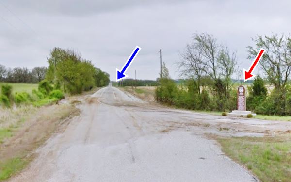
>> Click to read about the Route 66: The Ribbon Road
Abandoned Garage
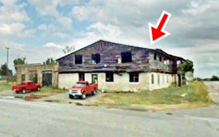
Turn left and head west towards Narcissa. As you approach the main intersection in the village (Route 66 and State Hwy. 25) you will see an abandoned garage to your left.
The property is abandoned, and falling apart. It was built in stone, a one story box-shaped building with two service bays to the left, and one on its southern side.
At one time a two-floor gable roof section was added to the original building (see red arrow in the image), it was torn down piecemeal, first the second floor and finally the first floor.
The 2002 Oklahoma Route 66 resources survey calls it the "Narcissa Garage... interesting stone building"
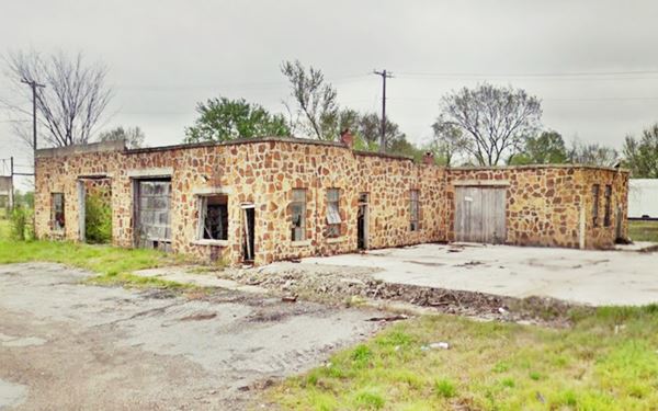
On the SE corner of US66 and OK-25 also to your left, once stood the D-X gas station. A historic site, now torn down.
Narcissa D-X Gas Station and store (Gone)
15050 South State Highway 69, Narcissa, OK.
Listed the station in the National Register of Historic Places in 2003 - Demolished.
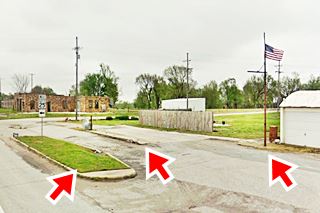
Lot where a historic Service Station and Motel once stood.
It was the main building in the small village of Narcissa, it was located (it has been demolished) on the eastern side of Route 66 in the center of the town.
The image shows what is left of the historic site: the curb on Route 66, the pumps island and another island by the flagpole (red arrows), you can see them all in the larger image below.
The original structure was built around 1910, near the railroad tracks, further west of the current highway.
Route 66 was created in 1926, and the demand for gasoline grew along the road's course, so the owner, Frank L. Gaines decided to move the store to land he owned along the roadside in 1934, where it was rebuilt and expanded. It remained operational until the 1990s.
This became the main intersection in Narcissa.
In 1935 Gaines granted the State permission to widen the narrow (see Ribbon Road) roadway. Work began shortly after and in 1937 the new wide road (current U.S. 69) linked Afton with Miami.
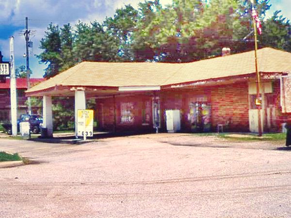
The business would thrive until the Will Rogers Turnpike bypassed the Route 66 segment between Joplin and Oklahoma City in 1957.
The building had a rectangular shape and a hipped roof extended towards the front. It had asphalt shingles and protected the pump filling area. It had a chimney and the complex also included a store and a motel.
There are no further sights in town, and this marks the End of your city tour. You can drive west and visit Afton, to continue your road trip.

Some sponsored content
> > Book your Hotel in Vinita


Credits
Banner image: Hackberry General Store, Hackberry, Arizona by Perla Eichenblat
Jack DeVere Rittenhouse, (1946). A Guide Book to Highway 66
Final survey report for the Oklahoma Route 66 Historic Resources, 2002. Michael Cassity
D-X station Historic Place Registration form. NPS.
Oklahoma, Miami Nine-Foot Section, National Park Service


