Peach Springs, Route 66
Index to this page

TheRoute-66.com is reader-supported. When you buy through links on our site, we may earn an affiliate commission at no additional cost to you.
About Peach Springs, Arizona
Facts, Trivia and useful information
Elevation 4,780 ft (1.457 m). Population 1,363 (2020).
Time zone: Mountain (MST): UTC minus 7 hours. Summer (DST) no DST⁄ PDT (UTC-7).
Peach Springs is a town located on the western border of Mohave County, in northwestern Arizona. On the historic Route 66 segment south of the Grand Canyon.
Peach Springs serves as the administrative headquarters of the Hualapai people, and is located on the Hualapai Reservation.
History
The Northwestern part of Arizona has been populated for at least ten thousand years and during the historic period, the Havasupai (also known as Supai) and the Hualapai people lived here.
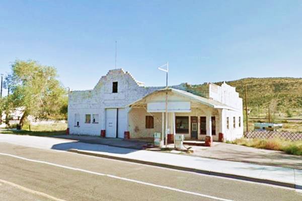
The Shell Service Station at Peach Springs in 2011
They were farmers and grew corn, beans, melons and squash. They lived in dome-shaped housesbuilt with branches and thachet with juniper bark.
The place was first reported by Father Francisco Garcés, a Franciscan missionary who camped here on June 15, 1776, while trekking to the Hopi villages to the east. He found the springs and called them Pozos de San Basilio, that is, Saint Basil's Wells. They are the head of Truxton Wash, now an intermittent flow of water, but at one time an stream.
They were rediscoverd by Mexican fur trappers in the 1820s, the Aguaje de Garcés, at that time the territory passed to Mexico after it became independent from Spain in 1821.
Mexico ceded the region to the U.S.A. after its defeat in the Mexican-American War of 1846-48.
American explorers like Ewing Young and Kit Carson named the spring "Surprise Spring" but they were also known as "Young Spring".
In 1857 the U.S. government sent Lt. Edward "Ned" Fitzgerald Beale to survey and open a wagon trail from Ft. Smith (Arkansas) to California; his route passed right through Peach Springs.
The Name: Peach Springs
The town owes its name to the peach trees that grew beside the nearby springs. It is a local tradition that they were planted by the XVIIIth Century Spanish missionaries that came from San Bernardino, California - a town that is also located on Route 66.
The Hualapai resisted the advance of the Americans but were defeated in 1874 after being starved out in Meriwitica Canyon and deported to La Paz, south of Parker, AZ. The new location was not suitable and many died so the government established the tribal reservation in 1883.
In the meantime settlers flowed along Beale's trail into California and the Atlantic & Pacific Railroad (later the Atchison Topeka and Santa Fe Railroad) laid their tracks next to it. The railroad set up a station at Peach Springs as it provided the water needed to run their steam powered locomotives (The Hualapai later litigated with the railway over rights to the springs).
The post office opened in 1887 and the railway built a "Harvey House" hotel for tourists who would then go up to the Grand Canyon via Dimond Creek. This initial period of prosperity ended in 1907 when the rail link from Williams was built to the South Rim of the Grand Canyon.
The National Old Trails Road was built in the 1910s and this brought tourists (in cars) back to the town. At that time it was merely a supply point for the proposed Diamond Creek Power Dam on Colorado River. The Trading Post opened in 1917 and when the National Old Trails Highway became part of Route 66 in 1926, traffic boomed. The Shell Station opened in 1929. The depression took its toll on tourism and only after World War II did traffic pick up again. But in 1979, I-40 bypassed the entire segment of Route 66 between Kingman and Seligman. The town declined until Route 66 was reborn as a "Historic and Scenic Byway" in Arizona.

Where to Stay in Peach Springs: Hotels
Spend a night in Peach Springs at its Hotel (sponsored content):
>> Book your Hotel in Peach Springs
More Lodging Near Peach Springs along Route 66
Find more lodging & accommodation nearby there are plenty of lodging options in the cities and towns along Route 66; click on the links below to find your accommodation in these towns:
Heading East: In Arizona
- 11 mi. Grand Canyon Caverns
- 37 mi. Seligman
- 60 mi. Ash Fork
- 79 mi. Williams
- 102 mi. Bellemont
- 113 mi. Flagstaff
- 137 mi. Twin Arrows
- 172 mi. Winslow
- 204 mi. Holbrook
- 250 mi. Chambers
Heading West: Hotels & Motels in AZ & CA
- 50 mi. Kingman
- 74 mi. Yucca
- 117 mi. Needles
- 256 mi. Barstow
- 278 mi. Helendale
- 286 mi. Victorville
- 296 mi. Hesperia
- 308 mi. Cajon Junction
- 322 mi. Fontana
- 324 mi. San Bernardino
- 329 mi. Rancho Cucamonga
- 361 mi. Los Angeles
- 372 mi. Hollywood
- 384 mi. Santa Monica
You are so close to Las Vegas!
Click on Deals: Opens in new window
Grand Canyon Hotels
Click on Deals: Opens in new window
>> RV campgrounds in Peach Springs
The Weather in Peach Springs
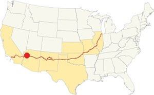
Location of Peach Springs AZ on Route 66
Peach Springs has a dry and sunny climate with 286 sunny days every year. There are 43 days with precipitation yearly.
Average summer High (Jul) 97° (36.1°C) and an average low of 58°F (14.4°C). It has a below freezing average winter low (Jan) of 27.8°F (-2.3°C) while the average winter high is about 53°F (11.7°C).
It only gets 3 in. of snowfall (7.5 cm) and 11 inches of rain (280 mm) every year. Most of it during the summer rainy period, as thunderstorms.
Tornado risk
This part of Route 66, to the west of the Rocky Mountains has virtually no tornado events. Tornado Risk: read more about Tornado Risk along Route66.
Map of Route 66 in Peach Springs

Thumbnail of the 1935 Arizona highway map. Credits
Click on thumbnail map to enlarge
Visit our Route 66 Map of Arizona and you will find Truxton and all the other towns located along the Mother Road in AZ. The map also shows the different alignments of US 66 over the years.
Check this Map with US 66 Historic alignment in Peach Springs and our custom map showing the sections that survive, but can't be driven (green line to the east, red line in Peach Springs, and a purple line, west of the town).
Getting to Peach Springs
You can reach Peach Springs using the Historic Old Route 66 in Arizona from Kingman (west) or Seligman (east) or via those towns using I-40.
Map of Route 66 in Arizona
Check out Peach Springs on our Route 66 Map of Arizona, with the complete alignment and all the towns along it.
U.S. highway 66 was designated as an All-American Road and National Scenic Byway in the state of Arizona.
The section of Route 66 that starts east of Seligman and, passes through Peach Springs, ending at Topock on the Colorado River is the longest remaining section of Route 66 in the entire U.S.A.
Route 66 Alignment near Peach Springs
With maps and full information of the old roadway.
- Kingman to Topock (next)
- Williams to Kingman (Peach Springs')
- Winona to Williams (previous)
Sights and Attractions in Peach Springs, Arizona
What to Do, Places to See
Historic context, the classic Route 66 in Peach Springs AZ
When Jack DeVere Rittenhouse drove down Route 66 in 1946, researching for his "A Guide Book to Highway 66" he gave a brief outline Peach Springs as follows:
courts: Quamacho, Peach Springs and Texaco; garage: Milligan; Quamacho Café no hotels; few stores; limited facilities. Rittenhouse (1946)
Of these one of the "few stores" survived two historic buildings: the Historic Peach Springs Trading Post, and the John Osterman Shell Station the Qumacho) has gone but the signpost remains.
Road Trip through Peach Springs
As you drive west towards the town coming from the Grand Canyon Caverns you will see the old 1926-1930 roadway to your left, on the south side of the modern alignment, along what is now Indian Route 19, heading towards the railroad at Nelson (where there is a plant producing lime) and then west into Peach Springs. See this map of the 1926-30 alignment. Then it was shortened to its present course, but it was later modified.
The 1940s to 1979 US66 continues, paved, all the way into Peach Springs north of the railroad and was later realigned in some spots its original 1930s-1940s alignment can still be seen from the highway.
We marked it with a pale green line in our custom map (east of Peach Spgs.) and also with this image map of the 1930-40s alignment.
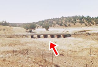
You can clearly see to the left (south side of the current alignment), an old bridge and the highway's original embankment close tothe Coconinio - Yavapai county line.
Peach Springs
The road descends into Peach Springs the "Capital of the Hualpai Nation", and on the eastern side of the town there is another segment of original highway on the eastern side of Peach Springs to your right, on the north side of the highway (1966 aerial photo), it has been built over when the modern High View Drive was built. (red line in our custom map).
Hualapai Lodge
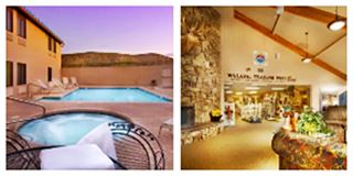
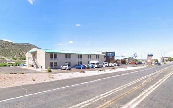
Start your tour at the Hualapai Lodge Hotel & Resort. The building, on the south side of Route 66 in the central part of the village is a hotel with a heated pool. There is a gift shop with tribal art and a restaurant.
Walk eastwards along Route 66 and to visit the local landmarks:
Osterman Auto Court site (gone)
John Osterman left Sweden in 1914 as a sailor on a German ship. Shortly after World War I brok was detained on the Mexican Pacific coast. He was interned but managed to escape and enter the U.S.
By chance he ended up in Peach Springs where he opened a gas station on the National Old Trails road. His brother Oscar came to America and he sold him the station. In 1926, hearing that U.S. 66 would be routed through Peach Springs he returned.
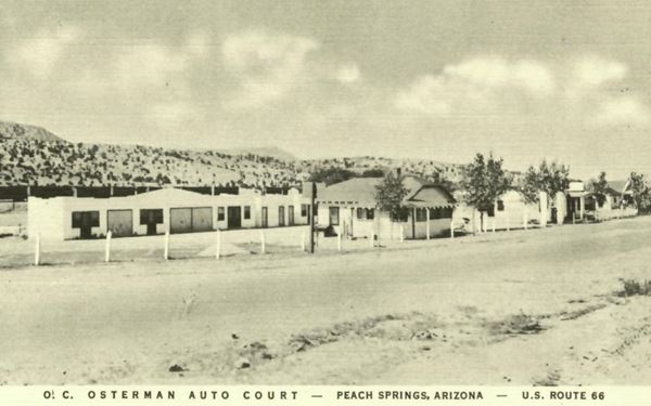
He built an "Auto Court" where the Hualapai Lodge is now located. Its vintage postcard below says "O! C. Osterman Auto Court - Peach Springs, Arizona - Elevation 4888. On the East End. A good place to rest. Spring water, shade trees. Modern cottages closed garages. Showers, gas, electricity." Below is a set of "Then and Now" pictures with the same scene. The modern hotel completely obliterated the old auto court, the cabins and office were torn down to make space for it:
Looking towards the southwest along Route 66 at Osterman's Auto Court in the 1930s
Site of Osterman's Auto Court nowadays (gone)
Mobile Station (gone)
On the western side of the property was a gas station, also torn down to make room for the hotel. It had a flat roof canopy. In the image below you can see the old auto court units behind, and the office to the left. This image looks towards the southeast. See this street view showing the same spot today.
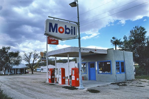
Frank and Beatrice Boyd bought the motel in 1938, and Beatrice ran it after Frank's death into the 1980s.
Continue west, on the next block, to your left is Osterman's historic service station:
John Osterman Shell Station
Listed in the National Register of Historic Places
There are different versions about who built it, and when it was built. One says John Osterman built it in 1927, another that his brother Oscar did so in 1932.
View of the historic Shell Service Station in Peach Springs in 2009
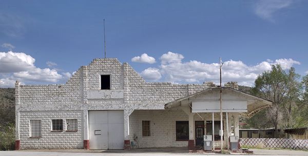
In 1932 the highway was realigned so he opened a new service station which he built to resemble the El Alamo mission in San Antonio Texas.
It has a concrete frame with a stepped facade, several bays and the walls were built with concrete blocks shaped to resemble stone.
Osterman Station in 2022 (roof parapet crumbling!)
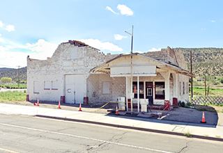
The block building has a trapezoidal parapet over the service bay with a storage space. The gable roof canopy covered the gas pumps. It remained in operation until the 2000s and was listed as a Historic Place in 2012.
Below is a view of the gas station from the 1930s, looking east. Route 66 is on the right side of the image. It is a detail of a vintage postcard (Click on it to see the whole postcard full size it shows both sides of the highway and a now gone Lou's Texaco station):
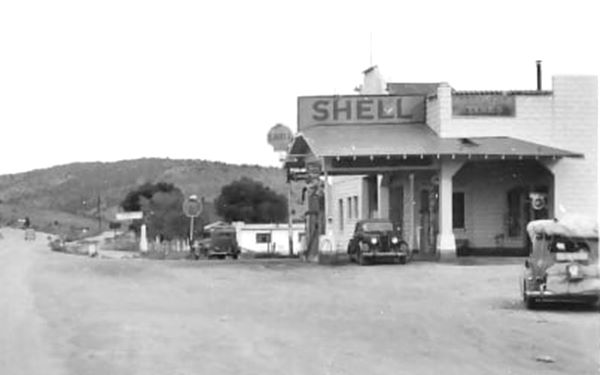
Cross to the north side of Route 66 and head west, past the Market and the post Office, you will reach the old historic Trading Post:
Historic Peach Springs Trading Post
Listed in the National Register of Historic Places
At 863 Highway 66, on the north side of the street. E. Carpenter opened the first trading post in 1917 and later added a partner, Ancel Taylor, who bought him out in 1924. They sold supplies to the natives and bought their handicrafts.
The original building was a wood frame store that also sold gasoline to those driving along the National Old Trails Road. In 1926 this road became U.S. 66 and more traffic drove by the store, boosting business. Taylor needed more space, so in 1928 he tore down the wood frame store and had the current stone building built by Cecil Davis. Below are a series of "Then and Now" pictures of the trading post:
A 1936 postcard showing the Trading Post in Peach Springs
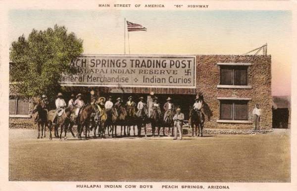
The postcard above depicts a swastika in the store's sign. This symbol is a Native American (Navajo) symbol and has no other connotation. Before being desecrated and appropriated by the vile Nazi's it had been for hundreds of years a religious symbol among many people around the world (Navajo and Buddhist are only some of them).
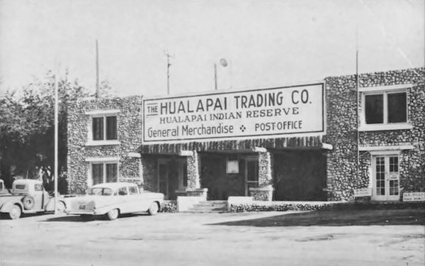
Same spot nowadays:
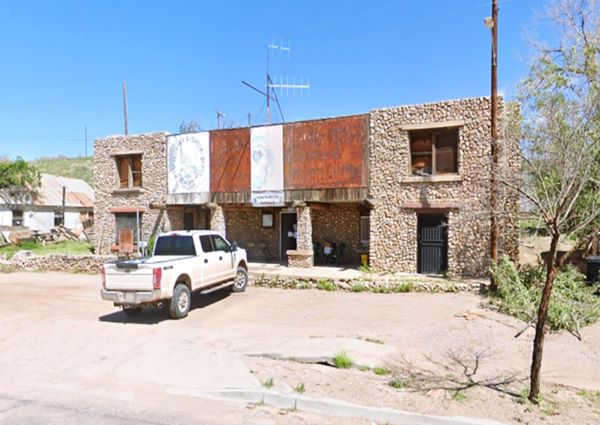
The building's style is Pueblo Revival, and it has stone walls, Ponderosa Pine beams jutting out of the walls in a "viga" style, large chimneys, and a high facade.
Taylor sold it in 1936 and it was finally acquired by the Hualapai tribe in 1950. It served as the post office and store. The post office moved out in 1965. Business fell off when I-40 bypassed the town in 1978 and it now houses the Hualapai Tribal Forestry, Wildlife Conservation, and Game and Fish.
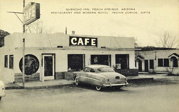
Qumacho Cafe site (gone)
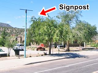
On the south side of the highway opposite the Trading Post is the site of the old Qumacho Café. All that remains is the steel pole that held up its sign as you can see in the "Then and Now" images below.
The postcard shows the "Cafe" sign and a bief description: "Restaurant and Modern Motel. Indian Curios. Gifts."
The motel was on the western side of the propert and the Cafe offered the "Catleman's Morning Diet" that included six eggs, one ham steak, potatoes, unlimited coffee and half a loaf of bread all for $2.78. The place was operated at one time by Guy and Ethel Rutherford, who in 1950s moved to Seligman.
It was listed in the "Green Book" (Negro Motorist Green Book or Negro Travelers' Green Book), a travel guide published each year from 1936 to 1964 by Victor H. Green. The guide provided African American travelers with a list of "black-friendly" dining and lodging places where they would be safe and comfortable during the dark era of segregation. He stopped publishing it after the Civil Rights Act was passed in 1964.
Notice signpost on the left side of the image
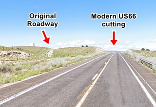
Original Roadbed
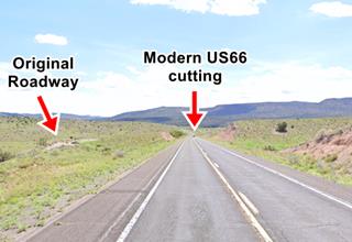
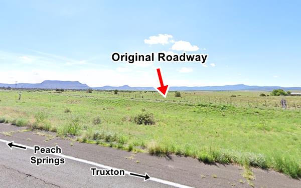
Drive west, towards Truxton, and will see some of the orginal roadbed of Route 66, dating back to the 1930s. The first section appears just east of the first cut after leaving Peach Springs.
The first highways in the early 1900s followed contour lines, avoiding cutting across hills. Instead they curved and skirted the slopes, it lowered the cost of building a cut across a hill. But in the 1930s when the highway was improved cuts were used to reduce the highway's length and avoid steep grades.
In the 1930s, cuts were adopted as they shortened highways and made them straighter and therefore safer, the modern course of Route 66 was built in the 1930s.
The old roadbed between Peach Springs and Truxton is marked with a violet line in our custom map of "missing segments".
The highway passed along the south side of the current alignment (street view) avoiding a low hill curving around it. Then it crossed to the north side and curved around another hill.
The image below looks east towards Peach Springs; the red arrow marks the old roadbed on the north side of the highway:
Then it swings to the south side once again to avoid another hill as you can see in the image above, that looks west towards Truxton.
It runs roughly parallel to the modern alignment and then approaches it from the left, meeting it on the eastern side of Truxton:
Continue your Road Trip
This marks the end of your Route 66 road trip in Peach Springs, go west into the next stop of your journey: Truxton.
Outdoors, National and State Parks
Diamond Creek and the Grand Canyon
The Grand Canyon and the Colorado River are located to the north of Peach Springs 15 miles (25 km) as the crow flies.
The Grand Canyon gorge here is 2,000 ft. (600 m) high and Diamond Creek, an intermittent stream, flows into the Colorado River at this point, flowing through the Hualapai reservation.
It was for many years the main tourist spot on the Grand Canyon, as it was one of the few places where the Colorado River itself could be reached easily, and there was a hotel at this spot, the Diamond Creek Hotel.
All this came to an end when the railway link was built between Williams and the Grand Canyon in 1907.
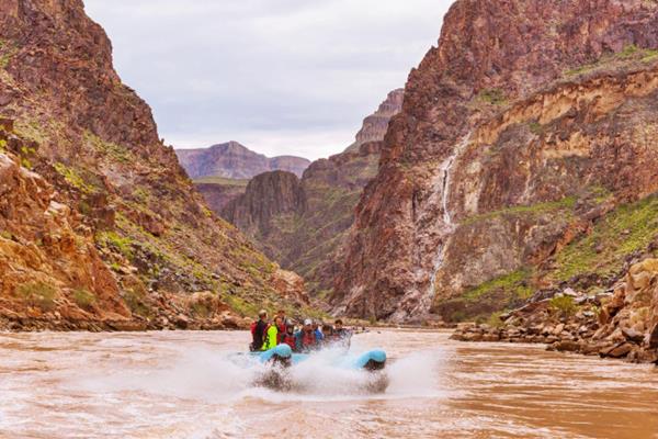
The Diamond Creek Road (dirt & gravel road) runs along the creek's canyon and provides the only access to the Colorado River between Lees Ferry and Pierce Ferry. The Hualapai tribal government charges a fee for all vehicles and people traversing the road (about $30 ⁄ person). Map of the road
Be careful with Flash Flooding during the rainy period. It can be dangerous and damage the road. The road is better suited for SUVs (don't take a rented vehicle along it as it may violate your rental contract).
Hualapai River Runners
Diamond Creek on the Grand Canyon is where the whitewater rafting trips start out from; you can book one-day Colorado River trips or whitewater rafting tours at the Hualapai Lodge. From March through October.
See a 360° view at Diamond Creek on the Colorado River
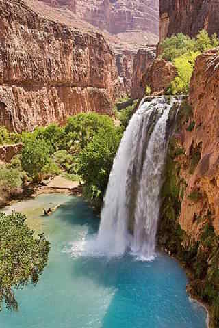
Havasu Falls. Credits
Supai and Havasu Falls
Further away (71 mi from Peach Springs) - Map of the part that can be driven, The final part of the journey is a 9.2 mile-long trek from the parking lot (trek map) are the famous Havasu Falls are located, close to the village of Supai, Arizona, in the Havasupai Reservation, close to the Grand Canyon's South Rim. The falls are pictured above.
The Hualapai Tribe
The Hualapai Tribe is a federally recognized Native American Tribe. "Hualapai" (pronounced Wal-lah-pie) means "People of the Tall Pines."
The Hualapai reservation was created in 1883, and covers one million acres, spanning the counties of Coconino, Yavapai and Mohave. It borders the Grand Canyon to the north and is home to 1,621 residents, of which 1,353 are tribal members. Another 1,000 Hualapai live off the reservation.
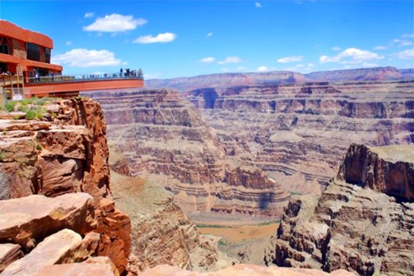
There are tour packages with great views from the Skywalk (a glass bridge that enables visitors to walk beyond the rim of the Grand Canyon at 4,000 feet (1.200 m) above the Colorado River).
The Grand Canyon Skywalk
90 mi. See the Map with Directions.
Opened in 2007 it is within the Hualapai Tribal land. It is a transparent horseshoe-shaped bridge that curves out and above the Grand Canyon 4,770 ft (1.450 m) above the Colorado River.
The best way to reach it is taking a tour as the roads are not in top conditions.
Read more at the Skywalk website.
Grand Canyon Skywalk
Sponsored content
Lake Havasu City

Lake Havasu City, the lake and London Bridge. Credits
The resort town of Lake Havasu City on Lake Havasu has beaches along the lake's scenic shoreline, an active nightlife and the original London bridge (you can take a Tour to visit it)

Some sponsored content
>> Book your Hotel in Lake Havasu City


Credits
Banner image: Hackberry General Store, Hackberry, Arizona by Perla Eichenblat
Jack DeVere Rittenhouse, (1946). A Guide Book to Highway 66.


