Index to this page

"Historic Route 66" sign in Santa Fe, Austin Whittall
- New Mexico Route 66 Itinerary and maps
- Historic background
- Santa Rosa
- Dilia
- Romeroville
- Tecolote
- Bernal
- San Jose
- Rowe and Ilfeld
- Pecos
- Glorieta
- Santa Fe
- La Bajada Hill
- Santo Domingo
- Algodones
- Bernalillo
- Albuquerque
Historic Route 66: Santa Fe Loop
New Mexico Route 66 Itinerary and maps
Each leg of Route 66 described below has an interactive map and many image maps so you can follow the alignments of the highway along the way:
- Glenrio to Tucumcari - Map of this segment
- Tucumcari to Santa Rosa - Map of this segment
- Santa Rosa to Albuquerque - Map of this segment
- The Santa Fe Loop (1926-37) - Map of this segment
- Albuquerque to Lupton - Map of this segment
Arizona, next leg
Texas, previous leg
When Route 66 went through Santa Fe NM
History of Route 66's alignment through Santa Fe
Route 66 was created in 1926 and its original alignment did not go through Moriarty, Edgewood, Tijeras, Carnuel or Clines Corners as it does now. Instead it took a curved alignment that headed north from Santa Rosa towards Las Vegas (New Mexico) and then west into the state capital city of Santa Fe. From here it headed south again to Albuquerque.
Ozark Trail
The Ozark Trail Association was the brain-child of William Hope "Coin" Harvey (1851-1936), an entrepreneur, teacher and active promoter of tourism. He foresaw the importance of the automobile in America and established the Ozark Trail Association in 1913 to promote good roads, road signs, and maps.
The Ozark Trail soon grew to span Missouri, Oklahoma, Texas, and eastern New Mexico. When Route 66 was created in 1926, part of its course was aligned along the Ozark Trail from NM to MO.
As there were no Federal highways at that time, monuments shaped like pyramids or obelisks were erected at key locations and the mileage to major cities were painted on the markers.
One can still be seen in Oklahoma (Between Stroud and Davenport). There was another at Romeroville, the western terminus of the Ozark Trail.
It was a 50 foot-tall obelisk that was located at the junction of the Santa Fe Trail and the Ozark Trail. That is, modern US 85 which followed the Santa Fe Trail from Santa Fe to Las Vegas, and current US 84, which linked Las Vegas to Santa Rosa NM, and would later become the 1926 - 1937 alignment of Route 66.
The reason for this 1926 Route 66 alignment was that the Ozark Trail had its westernmost point on the Santa Fe Trail at Romeroville and from there, eastwards, its alignment had been included in the alignment of Route 66.
From Romeroville westwards, the Santa Fe Trail was part of the National Old Trails, which was also incorporated into Route 66's alignment from Los Angeles to this point. It also went through the politically important city of Santa Fe, New Mexico's capital city.
There was no road at that time linking Santa Rosa with Albuquerque along a shorter alignment across the arid desert. So the existing roads were used for Route 66.
National Old Trails Road
In a similar way to the Ozark Trails Association, the National Old Trails Road Association was formed in 1912 with the purpose of promoting a good coast-to-coast highway between Los Angeles and Baltimore with branches to San Francisco and New York.
It got its name from the fact that it followed some of the Nation's historic trails such as the Santa Fe Trail.
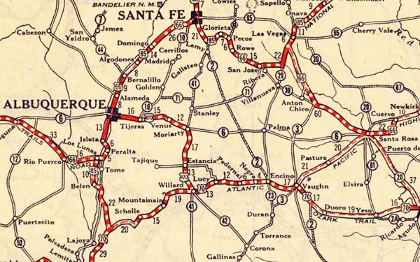
These first highways or "Auto Trails" in the 1900s are shown in the thumbnail map image (Click on it to see large size map), it covers the Santa Fe to Albuquerque area; the trails are marked with red lines.

1912 Road map, western NM
Click on image to enlarge.
Credits

1925 Road map, western NM
Click on image to enlarge.
Credits
The second thumbnail map above (from 1925) -click on it to see the full sized map- shows the roads that existed one year before Route 66 was created. Those marked "22" (National Old Trails Rd., coming from Los Angeles) and "32" (New Santa Fe Rd.) with white letters in a black box, went from Gallup to Albuquerque through Santa Fe. Highway "50" (Ozark Trails) had two forks, one from Albuquerque to Moriarty and then south through Clovis into Texas, and another from Albuquerque to Dilia.
The only paved sections (full black line) was between Albuquerque and Bernalillo, and Albuquerque and Tijeras. The highway from Bernalillo to Santa Fe, and beyond Isleta was "improved" (dashed line), the rest were either graded or dirt roads.
The Santa Fe "cut off"
Although the original alignment of Route 66 was based on necessity and followed the preexisting roads, it was a matter of time for it to adopt a shorter alignment with a straight east to west course along the 35th parallel across the state of New Mexico.
Arthur T. Hannett New Mexico's governor, who had been the mayor of Gallup, was aware of this and after being displaced in his 1927 bid for reelection by the party bosses in Santa Fe, took revenge in an unexpected way: He decided to bypass their city.
He ordered that a State Highway be built from Santa Rosa to Moriaty, placing Albuquerque on the main crossroads of the state and relegating Santa Fe to the backwaters.
The dirt surfaced road (New Mexico Hwy 6) was completed in record time in 1927 before he left office, but it would wait for ten years before it was incorporated into Route 66's aligment.
The Trans-America Footrace 1928 took this short cut and ran up Tijeras Canyon through Moriarty and on to Santa Rosa instead of going through Santa Fe.
This "Santa Fe Cut-off" (or shortening of Route 66) as it was known, was backed by the Route 66 Association and finally included in the Federal Aid (FAP) system for execution in 1931. It was finally completed by 1937. Santa Fe was cut-off and U.S. Highway 66 was shortened. Hannet got his revenge.
The Santa Fe Cut-off alignment of Route 66 after 1937
The new 1937 to 1985 alignment of Route 66 was the Santa Fe Cut-Off: it linked Santa Rosa with Albuquerque via Moriarty and Historic Tijeras Canyon. The shorter 1937 - 85 alignment passes through these communities from East to West:
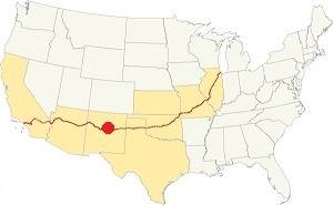
Location of the Santa Fe Loop
1926 to 1937 Route 66 in NM
- Santa Rosa (was on the 1926 alignment)
- Clines Corners
- Moriarty
- Buford
- Edgewood
- Barton
- Carnuel
- Tijeras
- Albuquerque (was on the 1926 alignment)
Original Route 66 alignment between Santa Rosa and Albuquerque
The 1926-37 Route 66 through Santa Fe
We describe below the alignment of U.S. 66 between Santa Rosa and Albuquerque between 1926 and 1937. Short lived, it only lasted 11 years, and little remains of its roadway. It was upgraded in 1932 but lost to the shorter alignment through the Sandia Mountains.
From Santa Rosa to Dilia
>> bordeaux line in our custom map is the 1926-85 alignment from Santa Rosa westwards that still exists.
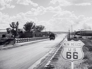
Pecos River US 66 Bridge in Santa Rosa, 1940.
Still from "The Grapes of Wrath".
Street View
Leave the town of Santa Rosa westwards and then head north (modern U.S. 84), cross to the north side of I-40 at Exit 273 to head westwards along the Interstate that now overlays the roadway of US 66.
>> pale blue line in our custom map is the 1926-85 US 66 overlaid by I-40
Ahead, after 7 miles the higwhay takes an east to west course and the original 1926-32 Route 66 to Santa Fe forks off to the north along Highway 379 at Exit 267. This was the original alignment of the Ozark Trail towards Romeroville and carried Route 66 until 1932.
The original alignment of Route 66 roadbed here resurfaces and you can see it on the north side of the Freeway (orange line).
>> orange line in our custom map is the old roadbed at Exit 267
Original Route 66 and US 84 towards Dilia and Santa Fe
The 1926-32 alignment of Route 66 or "Santa Fe Loop" forks to the right, and can be driven (dirt road! be careful!) in the first part of its alignment northwards towards Dilia (this is a map with directions showing this section according to Google, we don't recommend your drive along it).
The old road can no longer be driven, it becomes a rough trail. You can see it in the map below: driveable with care, dirt trail! (yellow line), non-driveable, no road (violet line).
>> yellow and purple lines in our custom map is the 1926-37 alignment to Dilia
There are some culverts along this alignment (violet markers
The 1932 to 1937 realignment
>> navy blue line in our custom map is the 1932-37 US66 realignment
The highway was realigned in 1932 following NM state highway 6 westwards and then taking a northern course towards Dilia. Head west along I-40 and leave the interstate at Exit 256, (18 miles). Head north along US 84. This is the 1932-37 alignment of Route 66 towards Dilia.
Dilia to Romeroville
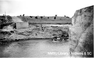
1937 washed out Pecos river bridge, Dilia. Source
The alignments meet south of the village of Dilia and head north to Romeroville.
>> bordeaux line in our custom map is an approximate alignment of US 66 across Dilia, to Romeroville
The current course of U.S. 84 more or less follows Route 66, but it isn't the exact alignment. For instance, there was a bridge across the Pecos river south of Dilia 3⁄4 miles west of the current one, it was washed away by the 1937 flood and only its abutements survive (see picture). The highway south of the river is gone, northwards it enters Dilia.
>> green line in our custom map is the 1926-37 Dilia alignment, green marker is the bridge
North of Dilia, there is another stretch of the 1926 highway to the west of modern US 84, it includes a culvert:
>> green line in our custom map is the original 66 north of Dilia, green marker is the culvert.
Romeroville

The obelisk at Romeroville, NM: an Ozark Trail marker now gone. ca. 1920. Source
The highway (now US 84) reached its northernmost point in the village of Romeroville. Just before the junction with US 85 and I-25, take a right along "Camino Romeroville", into the small village. It will lead you to the place where the Ozark Trail Obelisk once stood.
There is a grade crossing over the railroad tracks, and the highway meets the old U.S 85 roadway, now the South Frontage Rd. this follows the original US 66 towards Santa Fe (orange line).
>> orange line in our custom map is US 66 to Tecolote
Tecolote
Take a left and head west along the old U.S. 85, it is a short driveable segment that ends in a dead end. You will have to back track and get on to the I-25 at Exit 339 and head west along it towards Tecolote.
The original roadway was disrupted by the construction of U.S. 84 and its improvements in the 1940s and by the freeway's four lane aligment. The old road has some driveable segments, some lie in private property. Most is overlaid by I-25.
Arroyo La Manga creek bridge
On the left side of the freeway, one mile to the SW of Exit 339 (map with directions beyond the KOA Campground, 500 feet west of where the current road ends, is an original concrete bridge built in 1926 to carry US 66. Closed to traffic, surrounded by forested hills it marks the old roadbed. Pictured below.
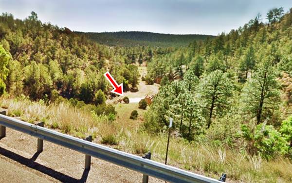
Romeroville to Tecolote
Almost the whole roadbed of Route 66 was destroyed when I-25 was built. You will have to drive along I-25 all the way to Tecolote. There is an old strip of the alignment east of Tecolote: at Exit 335 head to the eastern side and take the Frontage Road north to the "Camino Viejo" (Spanish for "Old Road") this 0.8 mile segment follows the original alignment.
Go back to the Exit, take the underpass, and head into the village.
Take the village's main street (B47A) southwards towards Tecolote Creek to see the remains of th Route 66 bridge (0.3 mi drive). The road ends there as the bridge is gone. But you can still see the concrete pylons in the river bed. It was replaced in 1940 when U.S. 85 was realigned to the east.
>> red marker in our custom map is Tecolote bridge site
The old road continues on the south side of Tecolote Creek (blue line) towards Bernal.
>> navy blue line in our custom map is the Tecolote to Bernal alignment of US66
From Tecolote to Bernal
Head out of Tecolote and take a right along the Frontage Road 2116, cross Tecolote Creek and turn right on the first street. It will take you to the original 1926 alignment of Route 66 (now Cielito Lindo Rd.) that runs with a north to south course from the creek and the "missing bridge". The dirt and gravel surface (rough) road keeps southwards and ends in a dead end just before it meets I-25, so you will have to return to the Interstate and head west towards Bernal (Map with directions of this segment)
The old road has a winding course and I-25 was built cutting right through it. So you can see bits and pieces of the 1926 alignment, including an old bridge and a section of the original paving. We show them in the following maps with directions in case you want to drive along them; may cross private property and most are tracks unfit for cars:
Gutierrez Ln, on the south side of the Interstate the continuation of the Cielito Lindo segment. Map with directions. On the western tip where it ends in a dead end, there is a strip of old roadway, pictured below. Blue marker in our custom map.
>> navy blue marker in our custom map shows the old roadway
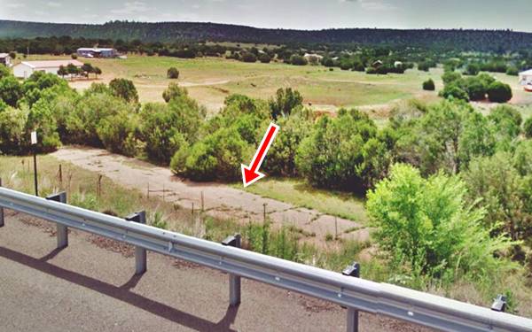
The road is cut by I-40, and resurfaces on its northern side as a very bad dirt surfaced trail that can't be driven even though it appears in Google maps: Map with directions. There is a former bridge, with some remains on this alignment (pale blue marker).
>> pale blue marker in our custom map shows the bridge remains
Bernal
The highway is again cut by I-25 and appears on its southern side, curving into Bernal and it can be driven almost all the way to eastern San Jose (Map with directions from Bernal to San Jose - driveable alignment).
In our custom map we mark the real alignment (blue line) that has several gaps in it, and some bridge ruins half way along its alignment (red marker).
>> navy blue line in our custom map is US 66 Bernal to San Jose, red marker is bridge ruins site.
San Jose
As the highway approaches the Pecos river by San Jose, it curves south to cross the river and go through the small town. It follows a now gone alignment along the eastern side of the river, and crosses a now closed steel truss bridge on the Pecos River to enter the village of San Jose. It was built around 1923 and has a asphalt covered timber deck. The road was paved here in 1932. See picture below.
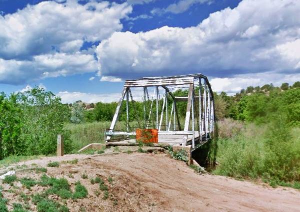
The highway curves west and then north, crosses the arroyo San Jose creek on the north side of the town (also built in 1923), and heads up the valley and then turns west again.
>> navy blue line in our custom map is ths 1926-32 San Jose alignment. Pale blue marker: steel bridge
The alignment was shortened, bypassing the town in 1933 (pink line). Ahead the freeway cuts the original alignment at exit 319, in Sands where it continues along its southern side.
>> pink line in our custom map is the 1933-37 San Jose cutoff US66
From San Jose to Pecos
>> red line in our custom map is 1926-37 US66 from San Jose to Pecos
The highway follows the Frontage Road from the access Sands and goes through the tiny community of Ilfeld, and then through Rowe where it crosses I-25 again becoming NM-63-
Pecos

Ruins of Pecos Pueblo,Pecos Mission Church in the background
This alignment runs along the western side of the Pecos river and then follows it north, crossing it and reaching the town of Pecos.
This was the site of a prehispanic Native American community that became the Spanish colonial village of Nuestra Señora de los Ángeles de Porciúncula de los Pecos (Pecos Pueblo for short) in 1619. The Santa Fe trail linked it with the colonial capital. The Atchison, Topeka and Santa Fe Railway built its tracks along the Trail in the early 1880s and when US 66 was created it followed this course across the southern foothills of the Rocky Mountains.
Route 66 from Pecos to Santa Fe
>> violet line in our custom map is the Pecos to Santa Fe Route 66 alignment
From Pecos, the original US 66 heads west (now NM-50) towards Glorieta following Glorieta Creek. The original alignment is a dirt trail and it follows the course shown in the map (violet line ) going through the town and crossing Glorieta Pass (7,560 ft - 2,304 m). It is cut by I-25 at Exit 299, and curves along its southern flank.
Take the freeway to cross the pass and reach the community of Canoncito (Spanish for "Tiny Canyon"). At this point you can follow the old Las Vegas road after Exit 294.
>> violet line in our custom map is the Canoncito segment, violet marker is an old culvert
The 1926-32 alignment is cut by I-25, and then runs along its southern side, there are some concrete slab fords along this alignment, a dirt rough trail.
>> violet line in our custom map is the 1926-32 alignment into Santa Fe, violet markers: fords
The highway was straightened in 1933 (pale blue line) carrying US 66 until 1937.
>> pale blue line in our custom map is 1933-37 US 66 into Santa Fe
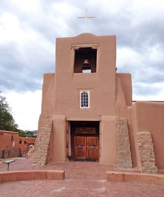
San Miguel Church, Santa Fe, Austin Whittall
Santa Fe
The highway reaches downtown Santa Fe and then turns south to head towards Albuquerque.
Santa Fe Trivia
Due to its height (7,200 ft - 2.196 m), it is the highest state capital in the USA.
Santa Fe is also the Oldest Capital City in America, founded in 1607 by the Spanish conquistadors.
San Miguel Mission (or San Miguel Chapel), pictured, is the oldest church in the United States. Building began in 1610 and finished in 1625. This Catholic church is still active.
Route 66 from Santa Fe to Albuquerque 1926 to 1937
There were two alignments linking both cities, the original one, unpaved took the treacherous Bajada de Santa Fe incline with hairpin curves and then ran with a westerly course. In 1932 it was paved and shortened. We describe both alignments below.
La Bajada alignment (1926-32)
Bajada de Santa Fe
>> navy blue lines in our custom map is driveable 1926-32 US66 west of Santa Fe.
The village of La Bajada (visit its church built in 1837) was established between 1695 and 1737 as a rest stop along the Spanish "Camino Real" (Royal Highway) that linked Santa Fe with Mexico City at the base of a 600 foot (183 m) escarpment. The name is Spanish for "The Descent", and it was a steep uphill or downhill road for the carts moving aling the royal highway.
The Spaniards used an ancient native foot trail for their highway and widened it. Later it would be used as a U.S. territorial wagon road (1860s), and become the NM-1 highway and the National Old Trails highway (1909).
There is a steep zig-zag road with dozens of hairpin bends that climbs from the lower mesa (La Majada Mesa) to the upper one (La Bajada Mesa). This winding road became part of US 66 and US 85 when they were aligned through here in 1926. There were very steep grades (up to 15 percent) on the climb, with switchbacks and dangerous curves (Further reading).
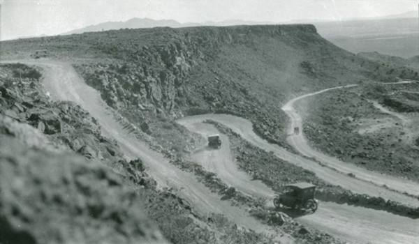
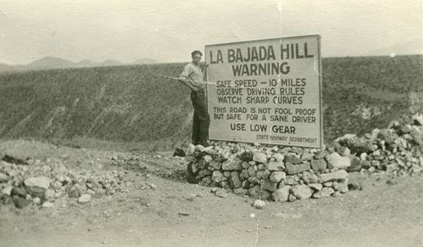
>> blue lines in our custom map is the Bajada alignment (yellow marker).
West of La Bajada
The old alignment has a gap (black line) as it heads west towards Domingo. Then there is a dirt road that can be driven, Indian Service Rte 841 to Domingo and beyond, to NM Hwy 22 (violet line). There are the remains of an old bridge (red marker) at Domingo on Galisteo Creek.
This is followed by another gap of dirt surfaced rough traces of trails all the way to I-25, meeting the Frontage Road by the Mormon Battalion Monument (black line).
>> 1926-32 US 66 West of Bajada, and in Domingo (black, violet lines)
The 1932 - 1937 alignment bypassing "La Bajada"
In the early 1930s the road between Domingo and Santa Fe was straighened out and the horrible hairpin Bajada into the Santa Fe River Canyon was bypassed. The road followed the current alignment of U.S. 85 (I-25) from Cerrillos Road in Santa Fe to Algodones. Santo Domingo was relegated, but you can leave the freeway at Exit 259 you can take a side trip to visit the Native American pueblo.
>> 1932-37 US 66 west of Santa Fe (green, yellow and black lines).
The yellow line in our custom map is the driveable alignment, mostly as the freeway's frontage Rd. The green line shows the alignment buried when I-40 was built over it. The black line by Exit 264 shows a ghost alignment that is still visible beside I-25.
Both 1926-32 and 1932-37 alignments meet at the The Mormon Battalion Monument and continue westwards overlaid by the freeway.
Route 66 alignments into Algodones
The later 1932-37 alignment is overlaid by the freeway all the way to San Felipe, and it is marked with a green line in our custom map.
Below we describe the earlier alignment.
The 1926-32 U.S. Hwy 66
This highway was originally dirt surfaced, unpaved, and has a winding course. Mostly a trace that can't be driven at all. The faint remains of it run along the north side of the freeway until it reaches the Arroyo Vega Tanos and crosses to the south side to ford it.
Little Gap
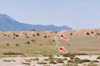
The highway then ran straight, cutting across the slope and ridge on the edge of a mesa on its southern side, this was known as the Little Gap (red arrows in image show cut and trail).
It continues straight across a flat area and becomes a dirt road that then meanders around some rough terrain as it approaches Arroyo Tonque. See the violet line in our custom map marking this segment.
Big Cut
Big Cut, Oct. 1932 US66. Source
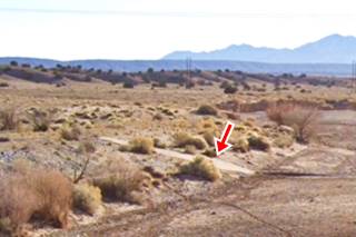
At the Arroyo Tonque, a wide gravel strewn river that is dry most of the year, the highway used a concrete slab ford to cross it. There are remains on both north and south side of the creek (pictured above).
The highway continued with a south course heading into the black mesa; across where the Casino complex is now located. See the teal line in our custom map.
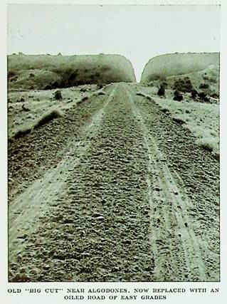
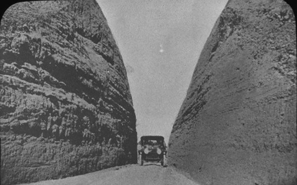
This roadway is mostly gone, some traces remain like a culvert (see map) but it can't be driven. The famous "Big Cut" is located here. It was a deep narrow cut across a ridge.
The image from an article published in October 1932 is captioned "Old "Big Cut" near Algodones, now replaced with an oiled road of easy grades," referring to the new 1932 alignment that bypassed it. Notice the rough dirt surfaced roadway with tire tracks.
The image below is captioned "Automobile in gravel hill road cut betweeen Algodones and Santa Fe, New Mexico."
After the cut the highway crosses yet another dry creek (Arroyo San Francisco), it curves west along the south bank of the arroyo and then curved south again along the Camino Real between Pueblo San Felipe and Algodones. This last section of the old road is cut by I-25; here it met the 1932-37 alignment.
Algodones
To reach the Camino Real leave I-25 at Exit 248, head right, westwards and then take left along Camino Real Pan American Central Hwy or NM-313, and follow it south all the way into Algodones a farming community in the Rio Grande river valley, located less than 3⁄4 miles from the river.
Bernalillo
Route 66 runs with a southwesterly course (pale blue line) following the river crossing Bernalillo.
>> pale blue line in our custom map is
Ahead, at Sandia Pueblo the highway merges with NM-556 at a roundabout. Head west along the highway, that soon becomes 4th St. NW.
Albuquerque
Follow 4th St into Albuquerque. This street carried US 66 from 1926 to 1937 into the city, but nowadays the Civic Center block has cut its alignment two blocks north of the 1927-85 US 66 on Central Avenue. Drive round the Civic Center to reach the end of this leg of your Route 66 Road Trip.
Crossroads of Route 66
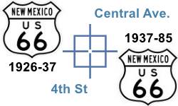
Fourth Street and Central is one of the few places along Route 66 where two alignments cross each other.
The original 1926 alignment ran along 4th Street across Albuquerque with a North to South course, from Santa Fe towards Isleta. It was the main highway and throughfare. However, in 1937 Route 66 was realigned along Central Ave, with an East to West course, from Santa Rosa through ABQ and onwards towards Laguna. U.S. 85 was aligned along 4th.
Read about the attractions along the 4th Street in Albuquerque.

End of this leg of your journey
Downtown Downtown Albuquerque is the end of this leg of your Route 66 Road Trip along the Santa Fe Loop.
There is plenty to see and do in Albuquerque:
Index to our six pages on Albuquerque & Route 66
Continue your road trip
Next Section
Parallel to this Section
Route 66, 1937-85 Main alignment Santa Rosa to Albuquerque
Previous Section

Some sponsored content
> > Book your Hotel in town Santa Rosa

Credits
Banner image: Hackberry General Store, Hackberry, California by Perla Eichenblat


