

Route 66 in Santa Rosa New Mexico
Index to this page

TheRoute-66.com is reader-supported. When you buy through links on our site, we may earn an affiliate commission at no additional cost to you.
About Santa Rosa, New Mexico
Facts, Trivia and useful information

Neon sign of the Sun n Sand motel. Click image for Street View
Elevation: Elevation: 4,616 ft (1,407 m). Population: 2,774 (2000). Time zone: Mountain (MST): UTC minus 7 hours. Summer (DST) MDT (UTC-6). Santa Rosa (Sun-tah Rousa), is the county seat of Guadalupe County, N. Mexico.
The Pecos River valley has been inhabited for over 10,000 years (the nearby archaeological site at Clovis NM has some of the oldest stone tools in America).
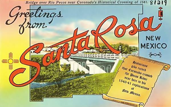
The area was later explored by the Spaniards (Coronado's expedition passed by Santa Rosa in 1540, fording Pecos River here). They added it to their American colonies as "Nueva México".
After Mexico became independent from Spain in 1821 this territory became part of Mexico. Later they ceded it the U.S. after their defeat in the Mexican - American War (1846-48).
Pecos River
The River flows along the western side of Santa Rosa and has been a route since prehistoric times. The river's headwaters lie in the north, in the Sangre de Cristo Mountains at an elevation of 12,000 ft. (3.700 m). Ir flows south for 926 miles (1.490 km) meeting the the Rio Grande. It drains a vast area of almost 45,000 sq. mi. (115.000 km2).
After becoming the U.S. Territory of New Mexico, the U.S. Army pacified the Kiowa, Kiowa Apache, and Comanche natives. White settlers arrived in the mid-1860s.
The first settlement in the area was established in 1865 and named Agua Negra Chiquita, which in Spanish means "Small Black Water", after a stream that flows near Santa Rosa. Its founder was Don Celso Baca.
Mr. Baca built a chapel in 1873 and named it after his mother "Rosa", and the Catholic Saint Rose of Lima.
The name: Santa Rosa
Saint Rose of Lima (Santa Rosa de Lima) was born in Lima, Peru in 1586. She died there in 1617. She was beatified in 1667 and canonized in 1671.
She is ths patroness of Latin America and the Philippines. Her feast takes place on August 23. Her real name was Isabel but due to her beauty she was renamed as Rosa (Rose) and is represented wearing a crown of roses.
The post office opened in 1868 and Guadalupe County was created in 1891, but the seat went to Puerto de Luna (Moon Port) located 10 miles south of Santa Rosa.
The small community did not get a boost until the Chicago, Rock Island and Gulf Railroad set up a camp there to build the line and the bridge over Pecos River. The railroad was completed in 1901, linking Santa Rosa with Chicago and later Los Angeles. In 1903 the County seat moved to Santa Rosa.
The townsite was promoted by C. H. Stearns. Although there are plenty of lakes and springs in the area, the "hard" water from the chalk laden soil made it unfit for drinking, so it had to be shipped in, in barrels.
Route 66 was created in 1926 following the preexisting "Ozark Trails" highway. The traffic benefited local business as cafes, diners, hotels, garages, and service stations opened to cater to the visitors.
Grapes of Wrath and Santa Rosa
The book by John Steinbeck and the movie it inspired, directed by John Ford, portrayed the tragic story of an Oklahoma family, the Joads, who lost their farm during the Great Depression and migrated to California seeking new opportunities.
In this Pulitzer Prize-winning work, Steinbeck (who later won the Nobel Prize in Literature) depicts their tragic journey (along Route 66). He also coined the phrase "Mother Road", referring to U.S. 66.
Read More: Grapes of Wrath, full details on the book and the movie.
There is a scene in the 1940 movie where Henry Fonda (interpreting Tom Joad) watches a train crossing the Pecos River Bridge, shot in Santa Rosa, and another with the truck of the Joads crossing the Pecos River. Both are shown below (stills from the movie).

Pecos River Railroad Bridge. large size image
Street View

Pecos River US 66 Bridge.
Street View
The truck scene is looking west but the Joads were heading from Oklahoma to California and should have been heading west not east. The scene must have been shot in the opposite direction to take advantage of the light.
The boom period lasted until I-40 bypassed the town in 1972 relegating many classic vintage shops as traffic flowed along the Interstate.
Vintage 1930s Postcard of Santa Rosa
Hotels in Santa Rosa
Where to stay or spend the night; find your hotel on Route 66 in Santa Rosa. It has plenty of lodging options for road trippers.
> > Book your Hotel in Santa Rosa
Lodging Near Santa Rosa along Route 66
Heading West
- 77 mi. Moriarty
- 116 mi. Albuqerque
The Santa Fe Route 66 segment
- 67 mi. Las Vegas NM
- 134 mi. Santa Fe
Book your room in Santa Rosa
Booking.com>> There are several RV campgrounds in Santa Rosa and also nearby at the State Parks.
Weather in Santa Rosa


Location of Santa Rosa on Route 66
Santa Rosa is located in a very dry area with about 15 inches (381 mm) of rainfall per year. Summer is hot but during the temperature drops during the night. Winters are cool.
Rainfall is higher during the summer with intense downpours: Between May and the end of Sept. around 9.5 in. of rain falls (241 mm).
Snowfall is moderate with an average of 13 inches of snow (33 cm). You may encounter snow at any time between Sept. and May but most (10 in. falls from Dec. to Feb.)
Average high temperature in summer (July) is about 92°F (33.3°C). In winter (Jan) the high is 54°F (12.s°C). The average low in summer is 61°F (16.1°C) and the winter low is below freezing, at 24°F (-4.4°C).
Tornado risk
Santa Rosa is located in an area with virtually no tornado risk: it only has two (2) Tornado watches per year.
Tornado Risk: read more about Tornado Risk along Route66.
Map of Route 66 through Santa Rosa

Map of US66 alignments in Santa Rosa
click to enlarge
Check out the map by clicking on the image, or by visiting our Route 66 Map of New Mexico, with the all the alignments of US 66 and all the towns along it in the state of New Mexico.
The color key for the map of US 66 through Santa Rosa is the following:
Blue, the original 1926 alignment coming from Cuervo, and now cut at the airport.
Pale Blue, the ca.1930s alignment, straighter, from Cuervo.
Below you can find more information on the different Route 66's alignments through Santa Rosa
Route 66 Alignment near Santa Rosa
With maps and full information of the old roadway.
- Albuquerque to Lupton (next)
- Santa Rosa to Albuquerque (Santa Rosa's)
- Tucumcari to Santa Rosa (previous)
Santa Rosa's Sights and Attractions
"Out Where The West Begins"

Texaco sign, Santa Rosa, click for St. View
- Sights and Attractions in town, read on below
- Parks and outdoors
Santa Rosa City Tour
Start your tour in eastern Santa Rosa at I-40s Exit 277 and drive west along the Route 66 alignment into town. As you leave I-40 to your right the towering Texaco sign with missing letters.
Ahead, to your right (Historic Marker just east of the Best Western.
Drive past the modern motels and some abandoned gas stations from the 1970s, to your right (Street View).
Shell station

Ranch style Shell station, Santa Rosa, click for St. View
In 1957 Shell launched the ranch style service stsation, it had a residential look, brick veneer, a large gable roof, no canopy, and a brick-faced chimney-like extension on the roof with the company logo.
Compare the Santa Rosa ranch station with this 1960s shell advertisement photo.
Route 66 Auto Museum
2436 Route 66, Santa Rosa NM
There are over 30 privately owned cars on display, including classics, vintage, chrome, street rods, and more. visit their website.
Santa Rosa Car Museum car atop a pole!

Former Esso gas station
Opposite the museum, just ahead, to your right is a white "oblong box" style gas station with a detached canopy from the mid 1960s. It has windows on its garage bay, two pump islands with vintage pumps under the canopy and the slogan "Happy Motoring!" that tells us it was an Esso station.

La Mesa Motel
2425 Route 66, this is a 1940s motel with a great neon sign from 1950 20 feet high and 12 feet wide. It has an arrow pointing towards the motel and a reversible reader box beneath it. The place is still operating as a Motel. It is pictured at the top of the page.
Rio Pecos Ranch Truck Terminal
Just ahead, to your left. An abandoned terminal that opened ca.1955. The neon sign is from that time. It is 30 ft. high and 33 ft. wide. It stradles the pump islands, fading and flaking in the sun. It portrays a truck with a trailer and a driver which had an animated arm. The beam supporting it acts as the roadway beneath the trailer.

Ellis Truck Stop
Ahead, passing the RV Park, to your left is another famous Truck Stop. Below is a then-and-now sequence of the place. The red arrow marks the café and the blue arrow the Mobil gas station. Both buildings are still standing. And the Café retained its triangular slab protruding from its facade.


Ahead, to the right is another former gas station, in good shape, with a Butterfly canopy, typical of Conoco and Enco stations from 1950 to 1970 (Street view.)
Shawford Motel now Econo Lodge
To your right (2295 U.S. Rte 66) is the former Shawford Motel, now the Econo Lodge Inn & Suites. As you can see in the "then and now" images below, it has changed its style from a Spanish Colonial one to an Italian sytle with arches.
The original structure is there (see red arrows marking the pool, the crests on the roofs, the gabled canopy and the base of the sign). The fantastic neon sign is, unfortunately, gone.
The postcard tells us it had "Deluxe accommodations - combination tub and shower - TV - Wall to wall carpet - Individual controlled Panelray Heat and Refrigerated Air - King size Rooms...".

Lettie’s Restaurant
Adjacent to the Econo Lodge, is the classic Lettie's Restaurant, now named "Route 66 Restaurant" (2295 Route 66), it was run by the Velasquez family from 1986 to 2019, when it closed for good.
Its neon sign with the word "Restaurant" written with each letter inside a yellow diamond is a Route 66 icon.

Downtown Santa Rosa
More Route 66 attractions
Route 66 descends, from the hilltop at Lettie's, passes under the freeway and crosses El Rito creek, to enter the town itself. To your left is the "Park Lake Historic District" and the access to the Blue Hole, 0.9 miles south (Map with directions.)

Park Lake Historic District
Will Rogers and Lake Drives, Santa Rosa, NM.
Listed in the National Register of Historic Places.
Built during the Great Depression, it is a municipal park next to the Blue Hole. The federal government created the "Works Progress Administration" or WPA during the Great Depression to employ local labor to build public works. In Santa Rosa the WPA built a 25-acre (10 hectare) municipal Park with a lake. It became a stop for those travelling along Route 66, to freshen up in the lake and picninc there. It has a recreational area and of course the lake which is fed by springs and drains through man-made channels into El Rito Creek.
Blue Hole
This deep pond is actually an Artesian well or spring, formed by an aquifer that is contained by impervious strata under pressure. When the stata is breached by a well or a lake, the water rises from the aquifer until it reaches hydrostatic equilibrium filling the hollow.

The "Hole" is fed by natural springs with quite cool water at 62°F (16.7°C). It is a lake 81 feet deep (25 m), 60 ft diameter (18.3 m).
Its clear water with a deep blue hue is enjoyed by divers, swimmers and scuba divers, which justify Santa Rosa's designation as "The Scuba Diving Capital of the Southwest".
Head back to Route 66 and head west. Ahead is a classic neon sign.

Sun n Sand Neon Sign, detail from a vintage postcard. Click for St. View
Sun and Sand motel neon sign
To your left the neon sign of the Sun-n-Sand Motel. Erected in 1960 it is 40 ft. high and 21 ft. wide, mounted on two steel poles with the words "Sun n Sand" set inside an orange Zia sun and motel in white letters on a blue background.
This is a Route 66 icon, you can see its current appearance at the top of this page. The image is a detail from a 1950s postcard. The sign is unchanged.
Two gas stations
Following the sign is a brick gas station repurposed as a storage site (street view).
On the next block, also to your left is a former gas station with canted plate glass and a butterfly canopy, maybe a Conoco station? (street view).
Across the street to your right is the now closed "Sahara Lounge".

1950s postcard, Sahara Lounge.
Sahara Lounge
The neon signs were removed in 2019, purchased by a private collector.
The Sahara belonged to L.G. Smith, who sold it to the McCowans in 1957. It closed in the mid 1980s. You can see what it looked like in the image below and in the postcard from the 1950s.

Sunset Motel, former Whiting Bros Motel
Just ahead, to your right (1835 US Route 66) is a former Whiting Bros. Motel. The building is relatively unchanged, even the neon sign has kept the "Motel" and lower boxes of the original one (though now it is painted yellow instead of red -see the arrow in the photo below).
It is still open and operating as a motel under the name Sunset Motel. Below is a "Then-and-Now" sequence.
Whiting Bros. Motel in a 1970 postcard

The big tree has gone, but the building is clearly recogniza ble.
Santa Rosas Whiting Bros. Motel today

Red arrow shows the sign
> > Read all about Whiting Bros on Route 66.
Will Rogers Motel
Across the street (1818 Route 66) is the former Will Rogers Motel, now the Route 66 motel. The then-and-now sequence below shows that the building is unchanged, but the neon sign and pool are gone, and the large trees have also been felled.

1950s postcard Will Rogers Motel, credits

The Will Rogers Motel now.
Street View
Joseph's Bar & Grill

Fat Man on Joseph's facade, click image for Street View. Credits.
Jose Campos opened the La Fiesta Drive In back in 1956 and has been run by three generations of Campos. It became Joseph's in 1985. It is a "Route 66 Roadside Attraction". The "Fat Man" at Joseph's is a tribute to the one originally used at Club Cafe which is now at the Route 66 Museum in Santa Rosa (more about this further down). If you are celiac like me, try their Gluten Free pizza!
Western Motel
Closed and abandoned, this old motel stands across from Joseph's. Its postacrd boasted "45 New Quier, Comfortable Units Tubs and Showers... Mr. and Mrs.Rudy Babins, Managing Owners".
The pool is there, and also the same office with its gable canopy, you can see it in a series of postcards from the 1950s, 1960s, and today. See how the neon sign changed over the years.
Santa Rosa's Western Motel in the 1950s, 1960s and today

La Loma Motel
On the hill, following Joseph's, is the aptly named "La Loma Motel" (loma is Spanish for "hill"). After World War II, Jose Campos Sr. (founder of Joseph's) opened the motel.
It is clearly the original building and neon sign as you can see in the composite image below showing a 1950s postcard and its present view.
La Loma Motel then and now

Standard gas station
Next to La Loma is the Mi Casa laundromat, a former Standard service station as you can see in this image which shows the view from the entrance to the Western Motel, looking west along Route 66. In the 1960s postcard you can see the Standard gas station; above is the same view nowadays. The long sign above the canopy is still there. This was typical design at that time: two islands and a massive sign supported by a thick steel column.

Club Cafe
There was a Conoco station following the Standard Station. Then comes the site of the long defunct Cafe, which was torn down and its neon signs have been removed.
What the old Club Cafe sign looked like


Club Cafe signs being removed in 2019, Enlarge
Back in 1935, Route 66 followed the alignment through Santa Fe, as the shorter route through Moriarty was not yet even planned. At that time Floyd Shaw and Phillip Craig formed a partnership to open a café, "The Club Cafe", and it was identified by the sign which portrayed a rotund smiling man with a coat and tie: the "Fat Man".
The grinning-face of the "Fat Man" appeared on billboards along Route 66 inticing travellers to stop at the Club Cafe. It served its final meal in 1991 and was later bought by Joseph and Christina Campos (owners of Joseph's). They had plans to reopen it, but it was beyond repair so it was torn down in 2015.
Tower Motel
The same L-shaped layout to the west and a wing on the east, with "32 modern units" and butterfly canopy by the office. The arrow and lower square of the original sign are still here too!. The motel is still operating.

The building following the motel was at one time a Mobil service station (Street View) and see its sign in 1960s Route 66 gas stations below as (1).

Court House
Ahead, to your left, is the red sandstone historic Guadalupe County courthouse was built in 1909. It is pictured below.
Continue west, on the southeastern corenr (301 Route 66) once stood a Whiting Bros station (2) in the image above. The steel pipe of the handicrafts store's sign, was probably part of the original one. On the next corner, at 201 Route 66 stood the Gull Wing Phillips 66, now razed. It is shown as (3) in the image above (next to the Phillips 66 shield atop the canopy sign pole. You can also see the wing-shaped canopy's edge as a diagonal red line).
Texaco station
The building across the street that now houses the American Legion was once a Texaco Gas station see its sign as (4) in the image further up. This building was updated in the mid 1960s, adding a Mansard roof (black arrow) to replace the flat one of the original oblong box gas station. The stone veneer (blue arrow) was applied to the original walls that stood between the garage bays (red arrows) and the office (still visible).

Guadalupe County Court House, Santa Rosa NM.
Credits. Click image for St. View

A Mansard roof Texaco. Santa Rosa NM. Click image for St. View
Bobby's Trading Post - Coronado Service Station and Courts
Adjacent to the Texaco is a very old property that has been on route 66 at least since the early 1930s. Nowadays it is Bobby's Trading Post, housed in an old building.
The site was originally a Conoco gas station that was part of the Coronado Courts (name given to motels at that time). You can see the remains of the original motel on the eastern side of the property.
The rooms are separated by a garage (red arrows), and have a semicircular parapet above the windows (blue arrows). You can see it in a 1930s postcard and in a current view below.

The postcard read "Coronado Service Station and Courts Car Service. Modern Heated Cabins, Some with Kitchenettes. Shade Trees. Rates Reasonable."

The service station at the Coronado was a Conoco, but later it became a Sinclair Station, marked as (5) in the image further up. It has ghost signs of the widely spaced green bands on the wall surface above the window openings that were used in from the 1950s to 1969 (see the green bands).

Western Santa Rosa, air view 1950s
The following image shows the western side of Santa Rosa seen from the air, looking east, in the 1950s (see the full large size image). In it you can see the service stations we have described above and those we will describe below. The red arrow marks the Gulf station, which was torn down.
Texaco #2
The last station in town on the westbound lanes, it is across the street from the former Sinclair. It is (6) in the image. Facing it stood a Gulf station, now gone (7). See its present appearance.
Cross the Pecos River bridge and to your right is the Rancho Motel (Street view), which has stood there since the 1930s. And on the corner of River Rd. and Route 66 is a marker. There is also a marker 0.6 miles ahead, also to your left (see below).
Surf Motel
To your left, on US 54 is the former Surf Motel, now an Americas Best Value Inn. It had "50 units Free T.V. in all Rooms, Room telephones" owned and operated by H. D. Ada and F. G. Allen.

Santa Rosa Marker
Ahead, on the eastbound lane is the Marker (Street View), with the inscription: "Text of Historical Marker Santa Rosa - Population 2,468 - Elevation 4,620 - The Spanish explorer Antonio de Espejo passed through this area in 1583, as did Gaspar Castano de Sosa in 1590. Santa Rosa, the Guadalupe County seat, was laid out on the ranch of Celso Baca y Baca, a politician and rancher in the late 1800s. It was named for his wife, Dona Rosa".
The text differs from an older marker (See postcard.
Motel Oasis
Now abandoned, behind Ortega's Wrecker Service, and a sign that says "Economy Inn", you can still see the ruins of the motel. The red and blue arrows shows the same structures in both images shown below.
This marks the end of your Route 66 trip through Santa Rosa.
National and State Parks
Santa Rosa Lake State Park
The park is 8.4 miles north os Santa Rosa along NM-91 (Map with directions).
Contact: (575) 472-3110. The reservoir is a place for fishing, camping, hiking, boating and bird watching. There is a campground and RV Park.
Lake Sumner State Park
40 miles southeast of Santa Rosa along US-84 (Map with directions).
Contact: 132 Lakeview Lane Sumner Lake NM, (575) 355-2541.
The reservoir on the Pecos River is set in the grassy plains and offers boating, fishing, birding and swimming. There are campgrounds and RV facilities too.
Route 66 segments near Santa Rosa
These are the sections of Route 66 in Santa Rosa. We describe each of them in a dedicated webpage with maps, itineraries and attractions along the way.
Alignment of Route 66
Some sponsored content
> > Book your Hotel in town Santa Rosa
Credits
Banner image: Hackberry General Store, Hackberry, Arizona by Perla Eichenblat
Jack DeVere Rittenhouse, (1946). A Guide Book to Highway 66.