Your Route 66 Road Trip in St. Robert
Index to this page

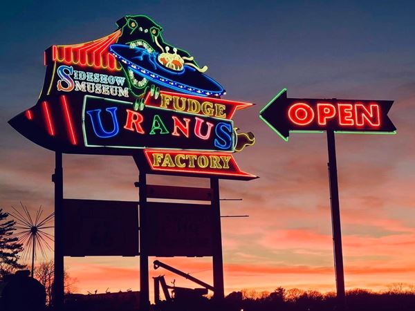
Route 66 Neon Mural, Uranus Missouri. Credits

TheRoute-66.com is reader-supported. When you buy through links on our site, we may earn an affiliate commission at no additional cost to you.
About St. Robert Missouri
Facts, Trivia and useful information
Elevation:1,040 ft (317 m).Population 4,340 (2010).
Time zone: Central (CST): UTC minus 6 hours. Summer (DST) CDT (UTC-5).
St. Robert is a town located on old US 66 in Pulaski County in Central Missouri.
History of St. Robert
For the general history of the area check the History of neighboring Waynesville.
It was originally a Dunkard community:The Dunkards, or Dunkers were called so becaue they believed in baptism by dunking, they are Christians of the Church of the Brethren, formed in 1708 in Germany.
Thisled the area to be known as Gospel Ridge, and later, Eastside as it was east of Waynesville. See the 1942 USGS map which shows it as "Gospel Ridge" at the junction of MO-17 and US 66. The two alignments of Route 66 appear in the map (the curved 1926-1977 roadbed and the straight addition built in 1942 that upgraded the road to a four lane highway).
The town was not platted and incorporated until 1951.
The name: St. Robert
The name comes from Father Robert Arnold, who established the Catholic parish for the staff at Fort Leonard Wood in the 1940s. So the first church, dedicated in 1951 was obviously St. Robert Bellarmine a Jesuit scholar (1542-1621).
The original Route 66 passed through town in 1926, aligned along old State Highway 14 east of Waynesville, the county seat. Just after World War II began and event though the U.S. was neutral, a large training camp named Fort Leonard Wood was created just south of what would become St. Robert. Route 66 provided a good road access and a railroad spur carried even heavier loads.
The heavy military traffic after 1940 led to Route 66's improvement from Doolittle to St. Robert: it was upgraded to a straighter four-lane divided highway. After the war , during the 1950s, the whole of Route 66 became a four-lane freeway, and I-44 was built, bypassing some of the old Route 66 sections and the town of St. Robert.
Getting to St. Robert
You can reach St. Robert using I-44 or historic Route 66 and Interstate.

Hotels: Where to Lodge in St. Robert, Missouri
There is plenty of accommodation options and hotels in St. Robert so you won't have trouble to find a room.
> > Book your hotel in St. Robert
More Lodging near St. Robert along Route 66
The towns along Route 66 also have lodging options. Click on the links below to find a room in any of those towns.
Hotels Westwards, MO, KS, OK
- 3 mi. Waynesville
- 36 mi. Lebanon
- 66 mi. Marshfield
- 78 mi. Strafford
- 91 mi. Springfield
- 151 mi. Carthage
- 168 mi. Joplin
- 184 mi. Baxter Springs
- 200 mi. Miami
- 215 mi. Afton
- 230 mi. Vinita
- 264 mi. Claremore
- 277 mi. Catoosa
- 290 mi. Tulsa
Accommodation eastwards in Missouri
- 26 mi. Rolla
- 37 mi. Saint James
- 51 mi. Cuba
- 69 mi. Sullivan
- 84 mi. Saint Clair
- 96 mi. Villa Ridge
- 103 mi. Pacific
- 113 mi. Eureka
- 130 mi. St. Louis
Hotels further East, in Illinois
- 135 mi. East St. Louis
- 142 mi. Granite City
- 144 mi. Pontoon Beach
- 151 mi. Glen Carbon
- 152 mi. Troy
Book your Hotel in St Robert
Booking.com>> Check out the RV campground in neighboring Waynesville
Weather in St. Robert

Location of St. Robert on U.S. Hwy. 66
St. Robert has well marked seasons; the average high during summer (Jul) is 88°F (31.2°C), while the average low is 67°F (19.2°C). The winter (Jan) the average high is 42°F (5.6°C) and the average low is below freezing at 20°F (-7°C).
Rainfall is around 44.5 in (1.131 mm) per year and falls regularly each month in roughly the same amount. Snowfall is 9 in. (23 cm) average, and falls between Dec. and Mar.
Tornado risk
St. Robert is located inside Missouri's "Tornado Alley" and Pulaski County is hit by some 8 tornado strikes every year.
Tornado Risk on Route 66:read more about Tornado Risk along Route66.
Map of Route 66 through St. Robert Missouri

1942 USGS map showing St. Robert MO and Route 66
When World War II began the heavy traffic and the large amount of accidents caused by the trucks heading to and from Fort Leonard Wood in St. Robert overwhelmed the old dual-lane Route 66. A safer road became necessary.
By 1943 the new road was completed bypassing the winding segment in Devil's Elbow (east of St. Robert). It had a straighter course. This is the map of the 1926-43 Route 66 into St. Robert.
To the west of MO-17, from 1926 to 1943 the highway crossed St. Robert along what are now the westbound lanes (map), During WWII two lanes were built further south and now carry the estbound lanes (map).
Visit our pages, with old maps and plenty of information about US 66's alignments.
- Springfield to Joplin (next)
- Rolla to Springfield (in St. Robert)
- Gray Summit to Rolla (previous)
Route 66 Sights in St. Robert
Landmarks and Places to See
Historic context, the classic Route 66 in St. Robert
Jack DeVere Rittenhouse published his "A Guide Book to Highway 66" in 1946 and of course, as the town did not exist at that time because it incorporated in 1951, he did not mention it.
Instead he described the area as follows.
State Patrol station is located here, with its radio tower in the grassy plot between the divided highway. Gas stations here also, and nearby is the entrance to Fort Leonard Wood... between Ft. Leonard Wood and Waynesville, 4 miles farther, there are several cafes, bars, gas stations, cabins, etc. built during the War. Rittenhouse (1946)
Begin your tour on the eastern side of St. Robert, on the south side of the freeway, at Exit 163. This is where the older 1942 four-lane Route 66 alignment cut the original 1926 alignment just south of Morgan Heights. Later, I-44 was built on top of the four-lane US 66 so no traces of it remain here. Drive west.
Old gas station
To your left, next to the highway and in front of the Best Western. It is a 1950s oblong box style gas station, with a flat roof, two service bays and a flat canopy (1970s addition?) over two pump islands.
Originally it was painted white, with a single red band across the upper part of the building. Pictured below.
Uranus Missouri
Americana & Route 66 Quirky and Kitsh sights
To your left, at 14400 Hwy Z (Old Route 66), St. Robert. This stop on the old Route 66 is a typical "Americana & Route 66 Kitsch" must-see site.
The old neon sign (pictured above) used to proclaim that "It's Not a Town, It's a Destination." Now a new family-friendly neon sign marks the spot. There is plenty to see and do. There is an old firetruck, dinosaurs, a Fudge Factory, general store, neon wall, the "World's largest belt buckle", a rocket, and more!
At one time the Mark Twain Motel and Restaurant stood here but it closed in the 1970s.
Mega Mayor muffler man

"Mega Mayor" muffler man, Uranus Missouri, St. Robert US 66. Credits
This muffler man is part of the Uranus complex. "Mega Mayor" was placed in its current position in March 2021.
It is a 22 foot-tall Muffler Man with a sash across its chest, and its shirt, bow tie, hat, pants and shoes emblazond with the stars and stripes, carries a yellow golf ball in one hand
and a putter in the other.
It has been made to resemble Louie Keen, the self proclaimed "Mayor of Uranus".
It stands facing the freeway on the western side of the property, to the right of Route 66 (map), and guards a 18-hole putt-putt mini golf. It is seconded by another gigantic (13 foot-tall) Walkiria-looking Miss Tiffany statue.
Learn more about the other giant Muffler Men on Route 66
Follow the old road, which here has some curves before heading straight into St. Robert at the junction with MO-17 - Missouri Ave. Nothing remains here of the cafes and gas stations that lined the highway. The four-lane Route 66 and later I-44 obliterated them.
Two miles south, to your left, along MO-17 is "Fort Leonard Wood".
Fort Leonard Wood
Named after Medal of Honor recipient General Leonard Wood (1860-1927) he was a physician and statesman. The Fort's construction began in Dec. 1940 after World War II began -but the U.S. was still neutral. It spanned 95,000 acres and accommodated 45,000 men. By the end of the war had trained 320,000 men. Now it is a center of the Army engineers. It has several indoor and outdoor museums.
Sights along I-44 in St. Robert
This is a short 2.5 mi drive to see three local landmarks on I-44 before driving Route 66. Map with directions. It will take us along I-44's frontage Rd.
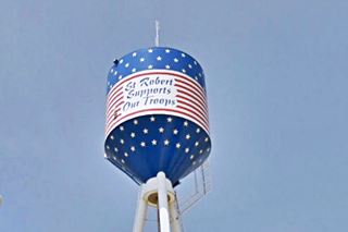
Patriotic Water Tank
Turn right along Missouri Ave, cross I-44 and just ahead, to your left is the town's the water tank next to the freeway with its stars and stripes motif (see picture).
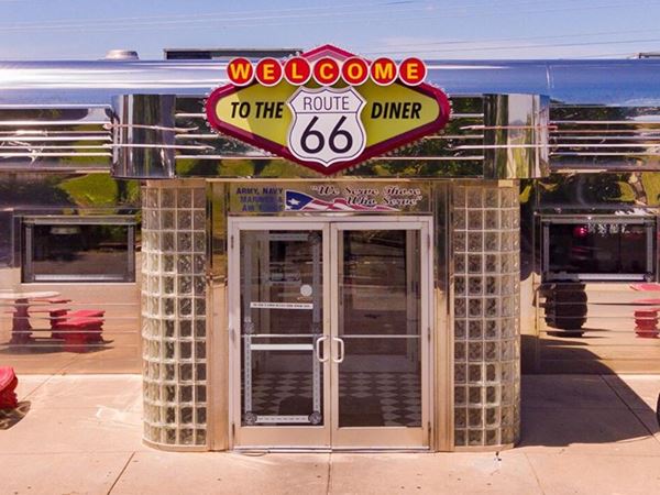
Route 66 Diner
126 Street Robert Boulevard, St. Robert. The diner is a step back to the 1950s, it is modern but designed with a retro look, stainless steel, neon, glass!
Drive on past the water tank and then along St. Rober Blvd. To your left, between the freeway and the boulevard, are the "Rocks".
Freedom Rock and military unit rocks

Freedom Rock, St. Robert MO. Credits. Click for street view.
The main rock was painted by Ray "Bubba" Sorensen II, of Greenfield Iowa, whose first "Freedom Rock" was inspired by the movie "Saving Private Ryan", he painted a graffiti covered rock to thank America's veterans. The rock in St. Robert is part of a Freedom Rock 50 State Tour. The rock pays tribute to General Leonard Wood, soldiers training at the local Fort, a P-51 Mustang fighter plane, a Fallen Soldier Battle Cross and a painted American flag.
Smaller rocks are painted with the badges of U.S. battalions and companies, and there is an M-60 tank too.
Continue west and meet Route 66's alignment on the western side of St. Robert. As the highway has two separate sets of lanes, we will drive east along the eastbound ones, and then return along the westbound ones.
East along Route 66
A short (1.1 mi) drive along the post-1942 Route 66 when it became a four-lane highway (map).
Oaks Court Modern Cabins
515 Old Route 66, to your right. Some units of the Oaks Court Modern Cabins still survive, though they have been remodeled. The main building was an ice cream parlor, and later during the late 1970s, it became apartments for
rent.
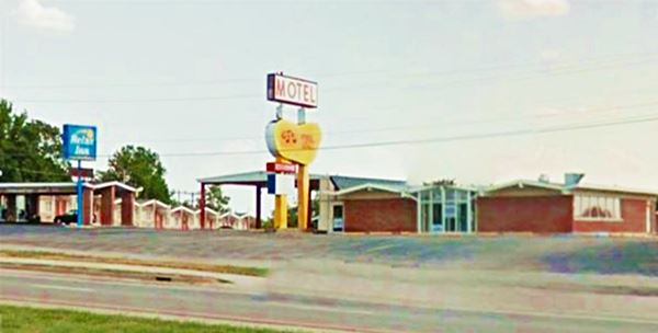
Next to it is a classic 1960s Route 66 motel, the Deville.
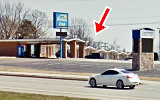
Deville Motor Inn, now Relax Motel
To your right, at 461 Old Route 66. The "Then and Now" sequence below shows that until 2009, the classic neon sign was still there. Now (see the other more recent street view, it has been replaced).
The surviving buildings to the west and north of the property have the classic 1960s Googie style saw-tooth shaped roofs atop the buildings.
The restaurant stood to the right (now replaced by a real estate company), ant the office on the left. The 1968 postcard says "Free TV, AM-FM Radio, Room Phones, Swimming Pool, Individual Controlled Heat and Air Conditioning, Ceramic Tub and Shower Combination, Carpeted, Coffee Shop and dining Room."
Vintage 1968 postcard of the Deville Motor Inn Motel in St. Robert, Missouri
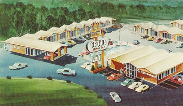
2009 view of the former Deville Motor Inn Motel in St. Robert, Missouri. Notice same neon sign as in postcard above.
Ranch Motel
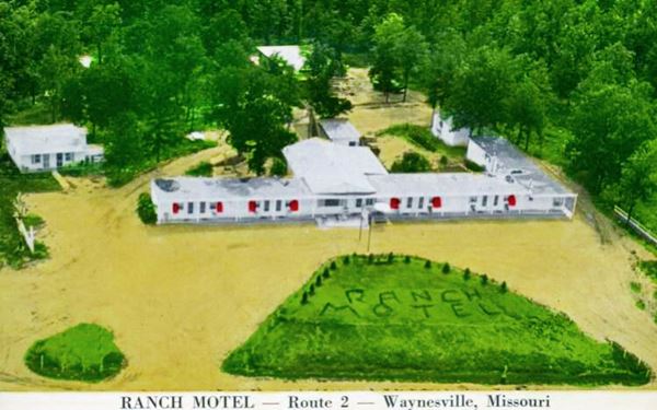
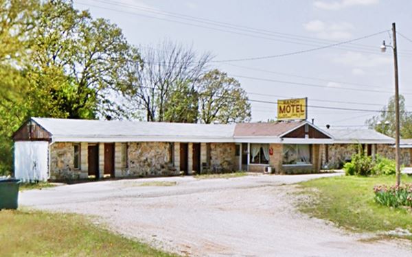
Next to the Deville, to the east, is the former Ranch Motel from the 1940s. It has a linear lay out, parallel to the highway. Below is a "Then and Now" sequence of images.
Rock FramePhillips 66
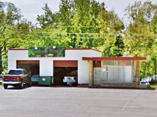
This is an old gas station with the typical "Rock Frame" style from the 1950s. It has slanting plate glass windows (like those of a control tower) with rock faced walls, the office has a flat roof and is lower than the double bay garage. See it pictured below.
George M. Reed Roadside Park
Ahead to your left, between the east and westbound lanes is the "Historic Route 66 George Reed Roadside Park".
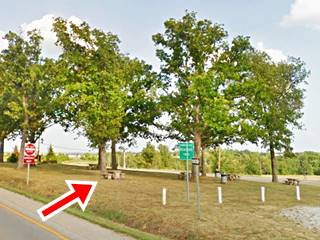
This park dates back to 1955, to the Route 66 golden days. It is the only remaining Route 66 roadside park in Missouri and home to a M-60 tank from the Desert Storm War.
It was named after George Marcellus Hamilton Reed (1855 - 1938), teacher, surveyor, lawyer, postmaster and newspaper publisher; after 1919 he was the Project Engineer of the Missouri State Highway Department, which is why the park was named after him. Dont miss the old tables and benches (one is marked with a red arrow in the image above).
Head West along old Route 66
On the eastern tip of the Roadside Park, turn left and then left again, to head westwards along the "original" 1926-42 Route 66 (Map with directions). You will drive by the old "Gospel Ridge Cemetery" or "Dunkard Cemetery", next to the highway (right) see its street view. Its oldest burials date back to the 1890s.
Alpine Haus Motel
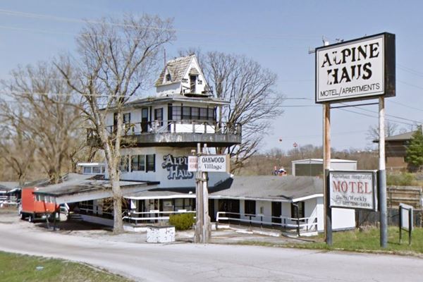
At 632 Old Route 66, to your right. This is another example of Route 66 quirky buildings, it is a motel with an "Alpine" theme, a four-story building topped by a cottage. It has 23 units.
Its sign also reads "Oakwood Village", which was the name of a cabins complex and gas station that stood here many years ago.
Head west, cross the freeway, to your right you will see an old gas station, on the right side of the Bank.
Cozy Acres RV and Skyline garage
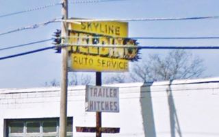
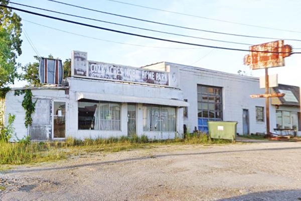
To your right, at 894 Old Rte 66. The welding shop has a classic neon sign that reads "Skyline Auto Service". It has a single bay service area in the concrete block building and an office to the right.
It opened in 1953 as the Skyline Garage Auto Service. Louis Ferkol and Willard "Chad" Chadwell ran it. The western (rusty) side of the old neon sign says "Garage", only later did it become a welding shop and the word "Welding" was added to the sign's eastern side
It is followed by the "Cozy Acres Mobile Home Park" offices that has housed "Cozy Arts" with a faded window sign that says it opened in 1968. Ran by Roberta Morris, it was an Adult Theatre and "tapes" store.
This marks the end of the St. Robert section of your Route 66 Road Trip. Head west to visit Waynesville.

Some sponsored content
> > Book your hotel in Lebanon


Credits
Banner image: Hackberry General Store, Hackberry, Arizona by Perla Eichenblat
Jack DeVere Rittenhouse, (1946). A Guide Book to Highway 66
Architectural - Historic Survey of Route 66 in Missouri and Detailed Survey, Maura Johnson. 1993


