Route 66 in Suwanee - Correo NM
Index to this page

TheRoute-66.com is reader-supported. When you buy through links on our site, we may earn an affiliate commission at no additional cost to you.
About Suwanee - Correo, New Mexico
Facts, Trivia and useful information
Elevation: 5,510 ft (1.680 m). Population: n⁄a.
Time zone: Mountain (MST): UTC minus 7 hours. Summer (DST) MDT (UTC-6).
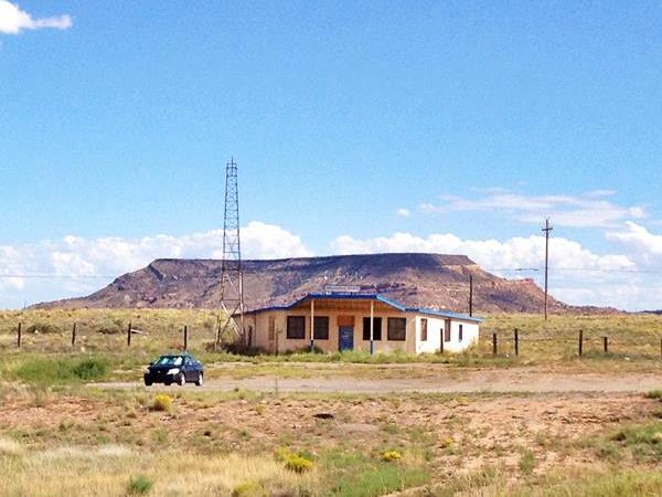
Suwanee is a scattering of houses along two old Route 66 alignments in Valencia county, NM.
Vintage Bar next to Route 66 in Suwanee - Correo, NM
History
People have lived in central New Mexico for over 10,000 years as shown by the nearby site at Sandia Cave. The rivers flowing down from the Rocky Mountains provided water for the later Pueblo people who farmed and irrigated their crops in the valleys of the rivers along the Rio Grande basin.
In 1540 the Spaniard Francisco Vásquez de Coronado explored the area searching for gold and called the native people "Pueblo", after the Spanish word for "village", based on their settlements.
The Spanish settled in New Mexico in 1598 but were expelled during the Pueblo Revolt in 1680. They returned in 1693 to resettle the area and subdue the natives.
After its independence from Spain in 1821 Nuevo Mexico province passed on to Mexico. After being defeated during the Mexican - American War (1846-48) Mexico ceded it to the U.S.A.
In 1880 the Atchison, Topeka & Santa Fe Railroad reached the area heading south from Santa Fe towards the Pacific coast. They extended its tracks from Albuquerque towards the southwest, crossing the Rio Grande and passing through the stations of Luna and Rio Puerco before heading northwest towards the mission at Laguna.
The Railroad built a depot and named it San Jose (St. Joseph), after the San Jose River that runs through the area into the Puerco River.
In 1902 it was renamed Suwanee because there already was a San Jose station in Oklahoma. A post office opened in Suwanee in 1917 and it was named Correo (Spanish for Post office and mail). A store was built next to it. The local school was a railroad box-car.
Origin of the name Suwanee
The popular song "Old Folks at Home", better known as "Swanee River" was written in 1851 by Stephen Foster. Its popularity led to many towns being named after the Suwanee River of Florida.
The origin of the word Suwanee is debated, one theory is that it is a corruption of the Spanish word San Juan to San Juan-ee after a Mission located on that river in Florida. Another theory is that it derives from the Shawnee Natives. Finally the word is supposedly of Cherokee origin, but they never lived in that region.
Correo on the other hand is a Spanish word which means "Mail", and is appropriate for a post office.
Suwanee Trivia
The Santa Fe Railroad geologic survey (1) of 1915 mentions that "Three miles west of Suwanee there is an extinct hot spring or geyser cone not far south of the tracks. It contains a shallow crater 30 feet in diameter with walls of a hot-spring deposit, which also constitutes the low cone in which it is situated. The form of the bowl and cone indicates that at a time not very remote there was at this place a hot spring, or possibly a geyser, similar to those now active in the Yellowstone Park."
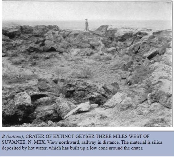
The image is captioned "Crater of Extinct Geyeser Three Miles West of Suwanee, N. Mex. Viwe northward, railway in distance. The material is silica deposited by hot water, which has built up a low cone around the crater."
One town two names: Correo and Suwanee
The local people used both names: Correo and Suwanee as the place name.
In 1926, Route 66 was aligned along the "Old National Trails" and headed south from Albuquerque to cross the river along the only bridge in the area, into Isleta, Peralta and Los Lunas. Then it headed west, towards the Puerco River following the railroad in this section. It passed through Correo - Suwanee and continued west.
Later the State highway NM-6 was paved and shortened the trip to Albuquerque. In 1937 Route 66 was realigned along NM-6, (the "Laguna cut-off") that shortened the road by linking Laguna via Correo - Suwanee to Albuquerque with a straight alignment, bypassing the towns along the Rio Grande alginment.
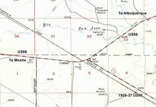
The post office that was beside the railroad depot (map marking where Suwanee depot was located) moved to the new crossroads in 1938 (the USGS map places Correo here). Much later a Standard service station was buit there.
Later, the post office closed (1945) and the town was bypassed by I-40 in the late 1960s.

Where to Stay: Hotels in Suwanee
Neighboring Albuquerque has plenty of lodging options for those driving along Route 66, you can book a hotel or motel in town:
>> Book your Hotel in neighboring Albuquerque
More Lodging Near Suwanee along Route 66
Below is a list some of the towns along Route 66 east and west of Suwanee, click on any of the links to find your hotel in each of these towns.
Heading West in NM and AZ
- 30 mi. Acoma Pueblo
- 48 mi. Grants
- 110 mi. Gallup
- 162 mi. Chambers
- 208 mi. Holbrook
- 241 mi. Winslow
- 276 mi. Twin Arrows
- 300 mi. Flagstaff
Heading East
- 36 mi. Albuquerque
- 75 mi. Moriarty
- 152 mi. Santa Rosa
- 211 mi. Tucumcari
- 289 mi. Vega, TX
- 326 mi. Amarillo, TX
- 421 mi. Shamrock, TX
- 460 mi. Sayre, OK
The Santa Fe Route 66 segment
- 99 mi. Santa Fe
- 158 mi. Las Vegas NM
Find your room in neighboring Albuquerque
Booking.com>> There are RV campgrounds in Tijeras, Edgewood, and Albuquerque.
The weather in Suwanee
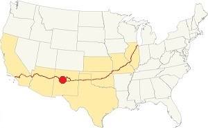
Location of Suwanee on Route 66
Suwanee is located just west of the Rio Grande Valley. Its climate is dry and sunny (278 sunny days per year) with a low relative humidity. There are large swings between day and night temperatures, even in summer.
Average High ⁄ Low Temperatures during summer (Jul.) are: 92 ⁄ and 65 °F (33 ⁄ 18 °C) respectively. The average high and low in winter (Jan) are about: 47 ⁄ and 24 °F (8 ⁄ -4 °C)
Summers are hot and winters are cold. Rainfall falls mostly during the summer monsoon season (July through September), and adds up to about 11 in. per year (279 mm). Snowfall is quite low: around 10 inches (25 cm) per year.
Tornado risk
Suwanee is located in an area with virtually no tornado risk: Valencia County has no Tornado watches.
Tornado Risk: read more about Tornado Risk along Route66.
Map U.S. 66 in Suwanee New Mexico
The first alignment of Route 66 in 1926
The historic 1926 alignment of Route 66 following the National Old Trails ran following an ample curve which headed from Santa Rosa towards Las Vegas, NM and Santa Fe. From there it headed southwards, to Albuquerque.
The "Santa Fe cut-off" shortened the road with a direct alignment from Santa Rosa to Albuquerque through Moriarty, Edgewood and Carnuel. This section was completed in 1937 along a new roadway to Moriarty and then along former US 366, that became US66 into Albuquerque.
Original Route 66 1926 alignment
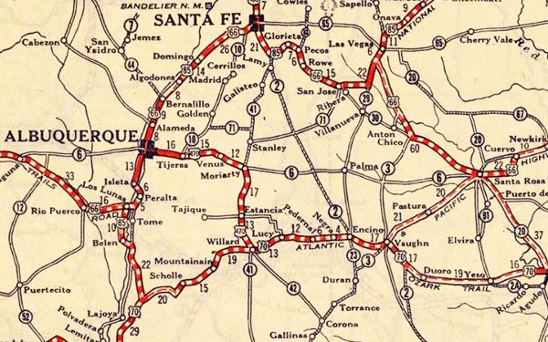
Albuquerque to Suwanee along the 1926 - 37 Route 66
Isleta, Peralta, and Los Lunas
The highway crossed the Rio Grande in Barelas and then along what is now NM 314, headed south along the western bank of the river going through the villages of Isleta, Peralta, and Los Lunas. There it turned west.
This section is now NM 6 higway. It flanked the Cerro de los Lunas mountain (5,957 ft) and then crossed the Puerco River. It ran close to the railroad and both skirted a 6,500 ft. high volcanic plateau (Mesa Carriza, Mesa Lucero) as shown in this Map to Suwanee, where it curved west, crossing the tracks and then went NW into Mesita and Laguna.
1937 Realignment of Route 66 South of Albuquerque
South of Albuquerque, the "Laguna Cut-Off" (named after the Laguna Mission Village west of ABQ and Los Lunas) eliminated the southern section of the 1920s alignment: in 1937 the whole highway was moved further north along NM State Hwy 6. It used the new bridges that crossed the Rio Grande on Central Ave., and the Rio Puerco after the nine-mile-hill. It climbed westwards out of Albuquerque and took a straight course towards Suwanee. Both Isleta and Los Lunas had been cutoff for good.
1937-50s alignment
The highway followed Central Ave., and in some parts is overlaid by I-40. After the Puerco River it continued west along what is now the N Frontage Rd. for 2.1 mi. (map), and then it turned south and runs under I.40s Eastbound lanes as marked with a red line in our custom map of missing segments all the way to Suwanee. Here as I-40 curves north, the original highway continued with a SW course.
The 1926-37 and 1937-50s alignments meet here in Suwanee, and then follow the original 1926 alignment westwards into Mesita.
Route 66 Alignment near Suwanee
With maps and full information of the old roadway.
- Lupton to Winslow (next)
- Albuquerque to Lupton (Suwanee's)
- Santa Rosa to Albuquerque (previous)
The Santa Fe Loop (1926 - 1937)
Our Santa Fe Loop page describes the complete 1926 to 1937 alignment of Route 66 from Santa Rosa to Albuquerque through Pecos, Santa Fe and Bernalillo.
Suwanee: its Ghost Town Attractions
Almost a Ghost Town
Suwanee is just a few scattered homes in a flat area between the Rio Puerco River and Mesita at the foot of some basaltic mesas. We will drive this segment coming from Albuquerque and heading westwards along the freeway.
Historic Context
Jack ritten house in his 1946 classic Guidebook to Route 66, mentioned Correo as follows:
Correo (Pop. 10) offers gas, groceries, small cafe, and a few cabins. As is the case with most roadside establishments along here, these places carry a display of curios, jewelry and Navajo rugs. Rittenhouse (1946)
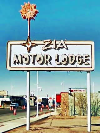
Iconic Neon Sign of the 1940s Zia Motel in ABQ. Click for street view
List of all Route 66 Attractions in Albuquerque
Check out our webpages that cover the sights and attractions in Albuquerque! there are many:
- Albuquerque Top 5 Things to See and Do & city overview
- Page 1 Eastern Albuquerque
- Page 2 Nob Hill
- Page 3 Downtown
- Page 4 Colonial Town & Western Albuquerque
- Page 5 4th St. Route 66 - 1926-37 Sights
Drive from ABQ to Suwanee
The first stop after Albuquerque is the historic Rio Puerco Bridge:
Rio Puerco Bridge
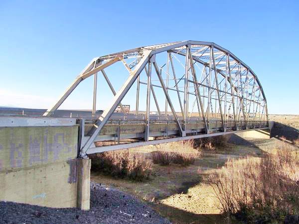
The highway original Route 66 reached the Rio Puerco River and crossed it on a steel bridge. The freeway's Exit 140 disturbed its alignment; the gap is marked with a green line in our custom map.
The bridge is located on the north side of I-40, on old US 66 in Suwanee, NM.
Listed in the National Register of Historic Places
Though the Rio Puerco is usually dry, it can flood and carry large volumes of water. For this reason the State Highway engineers chose a Parker through truss bridge to cross it.
Rio Puerco
The Rio Puerco is a tributary of the Rio Grande. Its sources are on the west slope of the Nacimiento Mountains and it flows 230 mi. (370 km) with a north to south course before meeting the Rio Grande about 50 mi. (80 km) south of Albuquerque.
It is a temporary river, and is dry during part of the year. Its average discharge is about 39.5 cu.ft.⁄s. (1.12 m3⁄s).
The name refers to its muddy and dirty waters (puerco means "pig" and therefore "dirty" in Spanish).
A Parker through truss type of bridge does not need a center pier to support it, and therefore eliminates the risk of it being washed away with flood water.
The placement of the bridge was strategic, it was built on a narrow spot with steep banks and was suitable for the 250 foot long single span bridge.
The bridge was built in 1933 on what was then NM State highway 6, employing federal funds for highway construction. It was part of the plan to shorten the transcontinental route and became part of Route 66 in 1937 when the "Laguna Cut Off" was implemented, bypassing Isleta and Los Lunas.
The bridge's deck is 25 feet wide. It was upgraded and remodeled in 1957. When I-40 absorbed the traffic of Route 66, it became its Frontage Road until 1999 when the NM Transportation Department replaced it with a new bridge. The old bridge was left where it was, and it is open to pedestrian traffic.
Rio Puerco Bridge, historic landmark
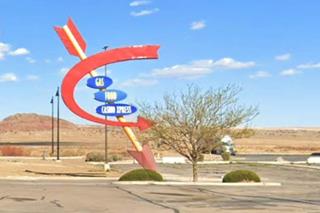
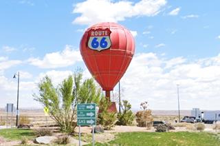
Across the Freeway, on the south side, the Route 66 Travel Center has some interesting retro-styled signs with Indian arrows and a 1950s-look to them!
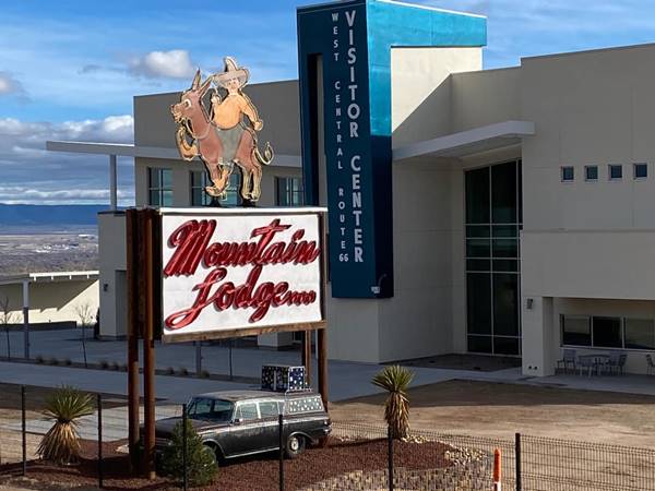
Route 66 Visitor's Center in Albuquerque is the home of the Old Carnuel Mountain Lodge neon sign pictured below. It has been repainted and now stands by the new Center:
The original two-lane highway continued west and at the spot where modern I-40 curves north, the original highway continued with a SW course straight into Suwanee.
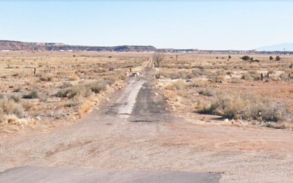
The image above looks east, towards I-40 and Albuquerque along the original 1937 to 50s Route 66 at the Suwanee junction where the alignments met.
My Personal Experience in Suwanee during my Route 66 Road Trip
My wife and I drove out of Albuquerque along the long nine-mile hill (which also has its share of classic motels) and then headed west along I-40 which we left at Exit 126 to reach Suwanee, heading south along NM-6 highway until we arrived at a bar - old service station named the "Wild Horse Mesa Bar". I took some pictures. Below is the Bar's sign.
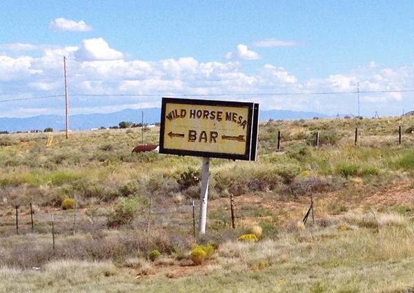
In 1951, the only buildings on Route 66 here were those whose foundations can be seen in this satellite view; they were torn down long ago. They are roughly 750 ft. north of the bar and you can see them in this 1951 aerial photograph. The current building at the crossroads; the bar is much more recent.
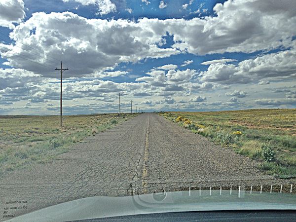
Here, by the bar, we turned left and crossed the tracks using the overpass on the 1926-50s Historic US Highway 66. It was cracked, rough, and full of potholes, with overgrown shoulders and, in some parts just plain dirt and gravel. Quite an experience! Below is a picture I took looking forward, through the windshield:
The original roadbed: Route 66 just west of Suwanee, NM heading towards Mesita:
Roadrunner Country
But we were very lucky because a roadrunner sprung out of the bushes, ran across the tarmac and then stopped in the shrubs on the other side of the higway, and we managed to photograph it (click on the image to enlarge it):
See the roadrunner inside the red circle:
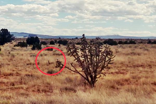
My childhood favorite was the Bugs Bunny Show, and two characters, Wile E. Coyote and the Road Runner were among my favourite. The greater roadrunner (Geococcyx californianus) is a long-legged bird related to the cuckoo family, that lives in the Southwestern United States and Mexico. Its legs aren't as long as Warner Brothers' Road Runner, but when I saw one in Suwanee, I felt great.

Road Runner and Wile E. Coyote

Bugs Bunny and the left turn in ABQ gag
By the way, the first time I heard about Albuquerque was when Bugs Bunny chewed on his carrot and studied his map, exclaiming:
I knew I should have made that left turn at Albuquerque Bugs Bunny c.1940s
Was Bugs referring to the 1937 change in the US 66 alignments (left would have taken him along the original alignment)! Cartoons and Route 66 are an indelible part of Americana.
The roadrunner's scientific name means "Californian earth-cuckoo"; it is also known as the chaparral cock, ground cuckoo, and snake killer.
After an uneventful drive across Roadrunner country we reached I-40 again, crossing it to head into into Mesita.
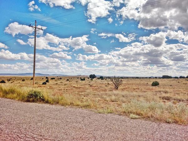
The arid enviroment where roadrunners live
Continue your Road Trip
Your Route 66 itinerary through Suwanee ends here. You can continue your Route 66 road trip by heading west into the next town, Mesita NM.

Sponsored Content
>> Book your Hotel in Albuquerque


Credits
Banner image: Hackberry General Store, Hackberry, Arizona by Perla Eichenblat
Jack DeVere Rittenhouse, (1946). A Guide Book to Highway 66.


