Route 66 in Tecolote NM
Index to this page
About Tecolote, New Mexico
Facts, Trivia and useful information
Elevation: Elevation: 6,297 ft (1,921 m). Population: n⁄a.
Time zone: Mountain (MST): UTC minus 7 hours. Summer (DST) MDT (UTC-6).
Tecolote is a small village located next to Tecolote Creek on the west side of US 85 & I-25. This used to be the Santa Fe Trail.
History
This part of New Mexico has been inhabited for over 10,000 years, the Pecos River was a main route linking the Sangre de Cristo Mountains in the north with the plains and the Llano Estacado in the southeast.
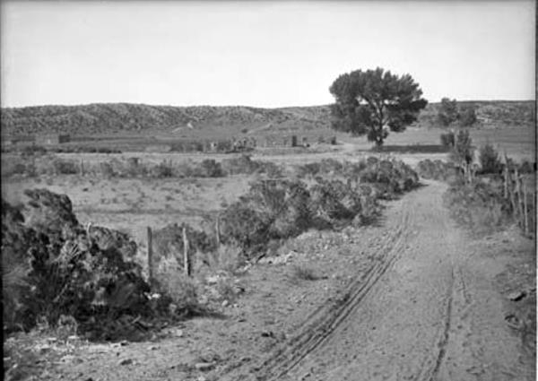
Old Route 66 "Camino Viejo", east of Tecolote.
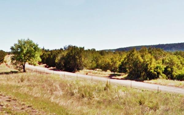
This area was not settled during the Spanish Colonial period between 1598 and 1821. It was a remote location, beyond the last pueblo (Pecos) and in a region that was subjected to the constant attack of the Comanche and Apache Indians that lived in the prairies in eastern New Mexico.
Only after Mexico became independent from Spain in 1821 did the area become settled. The first to live here was Salvador Montoya in 1824. But he and the other settlers faced the raids of the Natives and gave up in despair, abandoning their homesteads in 1828.
The present village was fomed when the Tecolote Land Grant was issued in 1838 by the Mexican authorities in Santa Fe, and it somehouw remained in place.
During the Mexican American War, brigadier general Stephen Watts Kearny (1794 – 1848) was ordered to occupy New Mexico, which he did. On August 15, 1846, he delivered a speech from the flat roof of a house in Las Vegas to tell the Spanish-Mexican people that he came to take possession of the territory, and would be their protectors, a friend, not a conqueror, respect their property, rights and religion. He mad the local officials swear allegiance to the U.S. This he repeated in Tecolote later that day.
After the Mexican American War, and once New Mexico became a territory of the U.S., the United States Army set up a post there to provide feed to the cavalry horses during ther campaigns against the Indians. The creek provided fresh water and it was strategically located on the Santa Fe Trail.
A post office opened at that time (1851), but in 1923 it closed and moved to Las Vegas.
A steady flow of settlers and goods were moved along the Santa Fe Trail but this decreased when the Atchison, Topeka and Santa Fe Railroad adopted a more southern course for its tracks in 1883, bypassing the town.
The name: Tecolote
"Tecolote" is a Mexican Native American language word for owls. The name of the town is probably linked to that of the mountain (7,240 ft.) located only 4 mi. north of it, and named "Tecolote Peak" with a truncated cone shape.
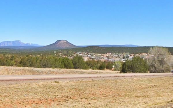
In 1926, Route 66 was aligned along the Santa Fe Trail from Romeroville to Santa Fe, passing through Tecolote. It would be on the Mother Road until 1937, when the Santa Fe Cut-Off shortened the highway by linking Santa Rosa with Albuquerque via Moriarty through the Tijeras Canyon and therefore bypassing this longer alignment through Santa Fe.
Accommodation near Tecolote
There is no hotel in town, but there are plenty of lodging options for those traveling along Route 66 in some nearby towns
> > Book your room nearby in Las Vegas (NM)
More Lodging along Route 66
Below you will find a list some of the towns along Route 66 to the east and west, with hotels and accommodation; click on any of the links to find your hotel in these towns.
Heading West
- 55 mi. Santa Fe
- 112 mi. Albuquerque
- 172 mi. Acoma Pueblo
- 192 mi. Grants
- 252 mi. Gallup
Heading East on Main Route 66
- 11 mi. Las Vegas NM
- 65 mi. Santa Rosa
- 124 mi. Tucumcari
- 202 mi. Vega
- 239 mi. Amarillo
Find your room in neighboring Las Vegas
The "other" Las Vegas, not the glamorous city in Nevada, this is a tiny town in New Mexico.
Booking.com>> There are RV campgrounds near Tecolote in Las Vegas NM
The weather in Tecolote
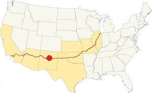
Location of Tecolote on Route 66
Summers in Tecolote are warm and winters quite cold. The area is dry.
The average summer high (Jul) is 83°F (28.3°C) and the low average is 52°F (11.1°C). In winter (Jan) the average low and high are: 22°F (-5.5°C) and 46°F (7.8°C) respectively.
Rainfall is higher during the period between May and Nov. (13 in. - 330 mm). The average rainfall is 16.5 in. per year (419 mm).
There are around 272 sunny days and about 62 precipitation days per year. Snowfall is around 27 in. per year, and falls between Nov. and March.
Tornado risk
Tecolote is located in an area with virtually no tornado risk: San Miguel county only has two (2) Tornado watches per year and mostly in the eastern fringe of the county.Tornado Risk: read more about Tornado Risk along Route 66
Map of Route 66 in Tecolote, NM
The orange line in our custom map shows the alignment of US 66 across Tecolote. The red marker is the site of the original Route 66 bridge.
The original Route 66 was aligned through Santa Fe in 1926 along three previous highways, the "Ozark Trail", the "Santa Fe Trail" and the "National Old Trails".

1925 Road map, Central NM
Click on image to enlarge.
Source
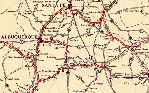
The thumbnail map from 1925 (click on it to see the full sized map) shows the roads that existed one year before Route 66 was created.
Notice "Tecolote Creek " on the center-right side of the map, though the village does not appear on the map.
Those marked "22" (National Old Trails Rd., coming from Los Angeles) and "32" (New Santa Fe Rd.) with white letters in a black box, went from Gallup to Albuquerque and through Santa Fe.
The only paved sections (full black line) were between Albuquerque and Bernalillo, and Albuquerque and Tijeras. The highway from Bernalillo to Santa Fe, and beyond Isleta was "improved" (dashed line), the rest were either graded or dirt roads.
The Santa Fe Loop (1926 - 1937)
This was the first alignment of Route 66, from Santa Rosa to Albuquerque via Pecos to Santa Fe.
We describe this segment in our Santa Fe Loop page, a dedicated webpage, with the full alignment, from Santa Rosa, through Dillia, Pecos, Santa Fe, Santo Domingo, and Bernalillo all the way to Albuquerque.
This original highway also continued beyond Albuquerque to Isleta, Peralta and Mesita.
Tecolote does not appear in this map either
1937 Realignment of Route 66
A political dispute between New Mexico Governor A. T. Hannett and local politicians led to the realignment of Route 66 in 1937.
Hannett blamed the local party bosses when he lost his 1927 bid to re-election. He decided to punish them, and their backers (the business men in Santa Fe) so he quickly had state highway #6 built, in 1927, to link Moriarty with Albuquerque. This highway bypassed the capital city, and was 90 miles shorter for those driving from the east to Albuquerque.
In 1937, the Federal roadbuilders decided to realign Route 66 using Hannett's road, and paved it. It was a straighter highway, and only had a short mountain segment across the Sandia Mountains between Sedillo, Tijeras and Carnuel.
Route 66 Alignment near Tecolote
With maps and full information of the alignments of Rte. 66.
- Albuquerque to Lupton (next)
- Santa Rosa to Albuquerque 1937-85 (parallel)
- Tucumcari to Santa Rosa (previous)
The Santa Fe Loop (1926 - 1937)
Our Santa Fe Loop page describes the complete 1926 to 1937 alignment of Route 66 from Santa Rosa to Albuquerque through Pecos, Santa Fe and Bernalillo.
Tecolote: its Attractions
Landmarks, Route 66 sights
The village is tiny, and is enclosed by I-25 & US 85 on the south and the Tecolote Creek on the west its main attractions are located around the plaza, traversed by the old Santa Fe Trail.
The Santa Fe Trail
During the Spanish Colonial period, Santa Fe was linked to Mexico City to the south by the "Camino Real de Tierra Adentro", a Royal Highway built by the Spanish Crown. Another important trail was opened in the 1792 across the Sangre de Cristo Mountains and the Great Plains to trade with the French Louisiana settlements on the Missouri River (now St. Joseph and Independence MO). It was known as the "Santa Fe Trail."
After the 1820s more traffic flowed along it, but it became safer to use after the 1846-48 war as the American army neutralized the Indian threat- Wagon trains used it to move goods from the east into New Mexico, and later, pioneers trekked along it to settle in California and the Southwest of the U.S.
Upon reaching New Mexico the trail split into two forks to reach Santa Fe, one of them went through Las Vegas, Tecolote and Pecos.
William A. Thornton (1802-1868) describes the trail in is diary and covers a Military Expedition to New Mexico in August 1855, and mentions Tecolote:
From Vegas to Tecolote the road better but our animals so much fatigued and jaded by the mornings work that we could not urge them beyond a walk. Country exceedingly pretty as we have entered mountain scenery and commenced crossing a spur of the Rocky Mountains. From the storm we could see at various points, remote and near at hand, the tops of the mountains covered with snow. The villages of Vegas and Tecolote made from unburnt clay and in appearances resemble unburnt brick kilns in the States. People poor and dirty. Flocks of sheep, goats and cattle very numerous. Wheat and c. raised by irrigation. From Vegas to Tecolote 10 miles... The scenery as we advanced towards Tecolote becoming more grand and beautiful. Our camp is located on a beautiful spot overlooking the mud village through which we had passed - distance about 22 miles. W. Thornton (1855)
Santa Fe Trail Marker
The Daughters of the American Revolution placed several granite monuments along the Santa Fe trail, there is one in Tecolote. on the southwest corner of the town's plaza.
The 1940 New Mexico A Guide To The Colorful State published by the WPA, described the town and its significance as follows:
...During the U.S. Army campaigns against the Indians in the last century, Tecolote was one in a chain of posts established to furnish frage and corn to Army units. The ruins of the headquarters buildings and the large stables still remain WPA (1940)
The trail later became part of the US highway system in 1926 when Route 66 and US 85 were aligned along it. Later in 1937 Route 66 moved further south, but U.S. highway 85 (and the I-25 Interstate) use the old roadbed and are kown as the "CanAm Highway."
CanAm Highway
This "highway" has a total length of 1,975 mi (3,179 km) and is an international highway linking El Paso,Texas, USA with La Ronge in Saskatchewan, Canada. Hence its name "CanAm". In the US it comprises U.S. Route 85 & I-25, both of which cross New Mexico and coincide with the old 1926 - 1937 alignment of Route 66 from Santa Fe to Tecolote.
Nuestra Señora de los Dolores Church

Dolores Church, Telocote in 1984. Douglas Keats
On the north side of Tecolote Plaza, the small church of "Our Lady of Sorrows", is an adobe building (said to date back to 1845) with an enclosed atrium, surrounded by an adobe and plastered stone wall. The building has a single nave and a pitched roof and a small steeple, centered on the roof.
The bell is not in the steeple, instead it is mounted on a structure in front of the church, in its atrium. Extensive restoration began in 1994, and the church was rededicated in 2000.
Remains of Tecolote Bridge
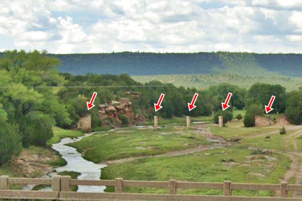
On the south side of the plaza, the original trail leads to Tecolote Creek, it was bridged in 1926 to carry Route 66 across it, but nowadays the street ends there as the bridge is gone washed away by floods. You can still see the abutements on both sides of the creek, and the concrete pylons in the river bed (red arrows in the image below).
End of this leg of your Road Trip
Here on the western side of Tecolote is the end of this leg of your journey. Continue your road trip by heading wesst to your next stop: Bernal.

Some sponsored content
> > Book your Hotel in Santa Fe

Credits
Banner image: Hackberry General Store, Hackberry, California by Perla Eichenblat


