

About Upland California
Facts, Trivia and useful information
Elevation: 1,237 ft (377 m). Population 73,732 (2010).
Time zone: Pacific (MST): UTC minus 8 hours. Summer (DST) PDT (UTC-7).
Upland is the westernmost city located along Route 66 in San Bernardino County in southern California. It is part of the Inland Empire, a metropolitan area located just to the east of the Los Angeles metropolitan area. (Map of Upland).
A vintage 1950s postcard looking north along N 2nd Ave. and 9th St., Upland
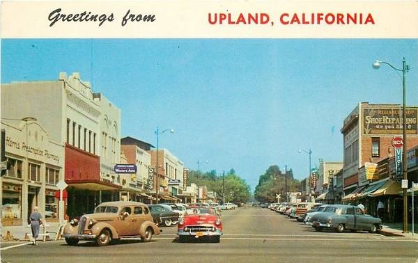
The same view in downtown Upland nowadays:

Click image for Street View
The History of the city of Upland, California
For the early history of the area, read the History of Rancho Cucamonga because what is now Upland was an uninhabited part of that ranch until 1882.
In 1882 George Chaffey, a Canadian from Ontario bought more than 8,000 acres of land in the old Rancho Cucamonga -together with water rights from San Antonio Creek. He had previously formed the community of Etiwanda, to the east of Rancho Cucamonga.
He built a main road running north to south through the agricultural community and named it after the Greek mathematician, Euclid. He named the colony "Ontario" after his hometown.
Present Upland was a part of the Ontario colony, lying along its northern section. It had been developed by the Bedford Brothers, who had named it "Magnolia" and in 1887 the Santa Fe Railroad built a station there.
The name: Upland
The whole area gradually became known as Upland.
The Bedford brothers established the original towniste in 1887 as Magnolia Villa. Later it became known as Upland after the Upland Citrus Association. Gradually the area became known as North Upland and then Upland due to the fact that it was located at a higher elevation than Ontario.
Ontario incorporated in 1891 and in 1901, North Ontario decided to incorporate too. The process was decided by the San Bernardino County in 1906, who also adopted the name of Upland for the new city.
The USGS survey along the Santa Fe railroad of 1915 says the following: "At Upland station the railway passes 2 miles north of Ontario, a city on the Southern Pacific Railroad, surrounded by wide areas of orange groves and other products of irrigation. Four miles to the northwest is the mouth of San Antonio Canyon, one of the large canyons in the San Gabriel Mountains, which furnishes considerable water for irrigation. On the plain its bed spreads into half a dozen irregular washes, which are crossed by the train between Upland and Claremont. From the gravel and sand under this plain a large amount of water is pumped for irrigation..."
National Old Trails Highway (N.O.T.) in Upland
By 1915, use of cars on the roads in California had grown considerably and the National Old Trails (N.O.T.) Association had advanced with their project for a highway linking Los Angeles and New York. This road followed the Santa Fe railroad tracks from California into Arizona and New Mexico. It was aligned along Foothill Blvd. in Upland.
The 1912 map by the Automobile Club of Southern California's map shows the N.O.T. road running west of Cucamonga and then going through Uplands -written with a final "S", 44 mi. from Los Angeles, from there it crossed the county line and reached Claremont (38 mi. from LA).
Route 66
In 1926, the N.O.T. road was incorporated into the brand new U.S. Highway 66. The road was slowly widened and improved, by 1939 the "Guide to the Golden State" written by the WPA, described it as follows:
" UPLAND, 17 m. (1,210 alt., 4,713 pop.), is a citrus-packing community with nine fruit-packing plants, surrounded by 6,000 acres of oranges and lemons".
The 1940s Caltrans road map shows Route 66 running across Upland from east to west as Foothill Blvd. with Olive located on the northern side of the city, on Highland Bvd. and Euclid Avenue running south through Ontario and beyond, past Chino. They were all separate towns at that time surrounded by rural areas.
In 1946, Jack DeVere Rittenhouse rode the whole of Route 66 and wrote "A Guide Book to Highway 66". In it he pointed out that the towns in this area "... are so close together as to be practically indistinguishable from each other..." his comment about Upland is brief: "Through Cucamonga at 329 mi., UPLAND at 332 mi and CLAREMONT at 334 mi."
In recent years, the urban sprawl of LA has expanded ant the fields have been developed. Many old Route 66 classics have been razed and replaced with malls or housing developments.
During the 1950s, the LA freeway system grew and diverted traffic away from Route 66 which was replaced here in 1964 by I-10; traffic along Foothill Blvd. dwindled.

Where to Stay in Upland
Lodging in the City
> > Book your Hotel nearby, in Rancho Cucamonga
More Lodging in Upland along Route 66
Motels and Hotels close to Upland, California
Heading East.... In California
- 4 miles Rancho Cucamonga
- 14 miles Fontana
- 18 miles Rialto
- 22 miles San Bernardino
- 27 miles Cajon Junction
- 50 miles Victorville
- 45 miles Hesperia
- 64 miles Helendale
- 87 miles Barstow
- 241 miles Needles
Heading West... Hotels & Motels in California...
- 5 miles Claremont
- 8 miles Pomona (south)
- 10 miles San Dimas
- 12 miles Glendora
- 15 miles Azusa
- 19 miles Duarte
- 20 miles Monrovia
- 22 miles Arcadia
- 26 miles Arcadia
- 32 miles Pasadena
- 36 miles Los Angeles
- 47 miles Hollywood
- 58 miles Santa Monica
Further East.... In Arizona
- 292 miles Kingman
Find your room nearby, in Rancho Cucamonga
Booking.com>> Check out the RV campground near Upland, in San Bernardino
The Weather in Upland

The weather in Upland is warm Mediterranean (Continental Mediterranean climate), which is semi-arid, it has hot and dry summers with cool - chilly winters.
The town has on average, 287 sunny days per year and the strong dry - hot Santa Ana wind blows through Cajon Pass during autumn (fall) drying out the area and increasing the risk of wildfires the foothill communities.
During winter, the average high is (Jan) 68°F (20°C) and the average low is 43°F (6°C). For summer the average high is 90°F (32°C) and the average low is 62°F (17°C).
Rainfall averages 17.3 in. per year (440 mm), with the period May to September being the driest one with less than 0.2 in. monthly (5 mm).
During winter, snow can be seen on the San Gabriel Mountains, but it does not snow along Route 66.
Tornado risk
As Upland is located right next to the Pacific Ocean, beyondthe Rocky Montains (western limit for tornados) so there is no risk of tornados there.
Tornado Risk: read more about Tornado Risk along Route66.
Getting to Upland
You can reach Upland along old Route 66 which here is the "Foothill Blvd." or via Interstate 10, 15, 215 or state higway 210. All of them are freeways.
The Map of U.S. 66 in Upland, California
Check out Upland on our California Route 66 Map, with the complete alignment and all the towns along it.
Upland's Map
Route 66's alignment in California: the Historic Route 66 into Upland
Route 66 across California
U.S. Route 66 does not have any Byway or Historic designation in California despite the survival of long sections of original roadbed between Needles and Santa Monica.
Click Here for an overview of Route 66 across the state of California.
Below you will find detailed information on Old Route 66 in Upland.
Sights and Attractions in Upland, California
What to Do, Places to See
Upland and its Route 66 attractions
Don't miss the "real" golden arches
Upland has several Route 66 landmarks: the now closed 1929 Buffalo Inn, a very rare McDonald's building with golden arches (1950s), the historic statue of Madonna of the Trail, an Art Moderne styled Grove Theater (1947), a Giant Route 66 Coffee Cup and the Taco King neon sign.
The view, towards the north is great, you can see the San Gabriel Mountains and the outstanding peak of Mount Cucamonga, which has an altitude of 8,911 ft. (2.718 m). These mountains are covered in snow during winter.
City tour
Start your tour at the eastern side of Upland, on the border with Rancho Cucamonga, west of Grove Ave., to your right is a neon sign:
Taco King Neon Sign
Americana
1317 E. Foothill Blvd., Upland.
A colorful neon sign at the Taco King restaurant. (See Street View).
Drive 2 miles west until one block before the Historic Euclid Avenue and to your left (south side) is the McDonald's golden arches, a vintage 1950s style of building used by the burger chain, very rare nowadays:
McDonald's Golden Arches building
100 E Foothill Blvd. Upland
This "vintage" McDonald's from the early 1950s sports the Golden Arches as part of the building's structure.
The McDonald's with the Golden Arches nowadays:

Click image for Street View
The McDonald brothers Maurice and Richard, decided they needed an eye-catching building for their restaurant and in 1952 hired Stanley Clark Meston from Fontana to design one. The brothers wanted arches to be a part of the building, Richard believed it would make it stand out and draw customers.
The stylized yellow parabolic arches stood 25 ft. (7.6 m) tall, one on each side of the building. The "golden arches" had been born.
They were used in the new restaurants opened between May 1953 and the 1960s, when the arches were eliminated from buildings, but survive until this day in the logo, as part of the "M".
Read about the other three memorable McDonald's on Route 66 in this part of California: the First ever McDonald's in San Bernardino (now a museum) and the Monrovia vintage logo McDonald's and the Golden Arches in La Verne.
Drive one block west and on the central plaza along Euclid Ave. to your right, where it meets Foothill Blvd. is the historic statue of the Madonna of the Trail:
Madonna of the Trail

View of the Madonna of the Trail in Upland. Google
Click for larger view
Listed in the National Register of Historic Places
1100 Block of North Euclid Ave. at Foothill Blvd., Upland
There are 12 monuments, one in each of the 12 states crossed by the National Old Trails (N.O.T.) highway, the California statue was dedicated in Upland on Feb. 1, 1929, and has stood there in front of Route 66 travellers for almost 90 years.
The Madonna of the Trail in Upland nowadays:
This statue is the work of sculptor Auguste Leimbach of St. Louis and it depicts a pioneer mother holding a baby with her left arm and a rifle with her right one. Another child clings to her. It is 10 ft. high (3.05 m). The statue was cast in 12 identical monuments made from alagonite stone (a mixture of Missouri granite, crushed marble, Missouri granite cement and lead ore).
These monuments were commissioned by the National Society of Daughters of the American Revolution (NSDAR) and they stand as a symbol of the courage of the pioneer women who stood by their families and helped tame the West.
The NSDAR established in 1911 a committe to promote and organize the highway that became the N.O.T. and later, in 1926, Route 66. There is another one on US 66: the Madonna of the Trail in Albuquerque NM.
Euclid Avenue
Listed in the National Register of Historic Places
Central Upland. See Map.
This avenue was planned by Chaffey, founder of Ontario and Upland as the main road in the city, it runs north to south from San Antonio Heights to south of Ontario. When built in 1882, it was a 200-foot wide avenue with a central parkway, with an electric tramline running along it.
He named it after Euclid of Alexandria (325 BC - 265 BC), a Greek mathematician often referred to as the "father of geometry".
The Bridle Path, used for jogging and walking runs along the central parkway for 3 miles, north of Foothill Blvd.
Before continuing west along Route 66 take a detour into the Old Town of Upland to visit the Grove Theater:
Grove Theater
276 E 9th St., Upland, 1 mile southeast of Foothill Blvd. and Euclid Ave. (Map with directions).
This old movie theater located in the Old Town Upland was built in 1947. It could seat 831 spectators in its single floor air-conditioned auditorium.
Its main feature is a stylized tower with the name "Grove" written vertically on three of its sides.
The Grove movie theater nowadays:

Click image for Street View
It is still in operation after being renovated in 1990. Read more about it at the Grove Theater website.
Go back to Euclid Ave. turn north to Foothill Blvd. and take a left along it, heading west once again for 0.8 mi. until reaching N. Mulberry Ave., cross it and look towards your right; there is another Route 66 "Americana" sight:
Giant Cup of Coffee
Americana
1013 W. Foothill Blvd. North side of the Road by the curb.

Giant coffee cup in Upland. Google
A typical Route 66 example of Americana, for coffee lovers, this steaming cup of coffee nesteled among the trees on the south side of Route 66 is quite an attraction.
This coffee cup is located in front of a coffee shop, so you can get your photo and sip your java at the same time.
Keep west for 1.3 mi., and to your left, on the South side of the road, closed for good but still there -until the plot is redeveloped- is the former Buffalo Inn:
Buffalo Inn - closed
1814 W. Foothill Blvd., Upland
The place has been serving food to customers driving along Route 66 since 1929. It is a pity that it closed. You could eat its special buffalo beef burgers and sit in its shady "beer garden".
The Buffalo Inn nowadays:

Click image for Street View
Upland Lemon Festival
This event takes place every year in April, since 1997. It is completely focuses on lemons (the basis of the town's citrus industry): so there is a lemon pie eating contest, Lemon Idol vocal contest, citrus crate labels exhibit, food competitions and bands. Admission Free in downtown Upland.
Read more at the Lemon Festival Official website.
Tours & Itineraries
The Alignment of Old Route 66 in Upland California
From Rancho Cucamonga to Upland
The first road through Upland was the National Old Trails highway (N.O.T.), which was planned in the early 1910s and linked Los Angeles with New York. It followed the Santa Fe railroad tracks in California, Arizona and New Mexico.
The Madonna of The Trail statue in Upland is one of 12 installed in each of the states through which the N.O.T. road goes through.
Route 66 followed the N.O.T. up to Romeroville in New Mexico, and east of that point it followed the "Ozark Trail" through Texas, Oklahoma and Missouri, up to Saint Louis.
Route 66 in Upland
Back in California, Route 66 between Rancho Cucamonga and Upland is a simple segment, both towns are next to each other so you will not notice where one ends and the other begins.
Route 66 extends for 4.1 mi along Foothill Boulevard in Upland, from Grove Ave. in the east to Monte Vista Ave in the west of town, on the county line between Los Angeles and San Bernardino.
This is a Map of Route 66 in Upland.
> > See the previous segment Victorville to San Bernardino
> > See this segment San Bernardino to Pasadena (west)
Accommodation Search box:

Sources
A Guide to the Golden State, by the Federal Writers' Project of the Works Progress Administration, Hastings House, New York, 1939.
Banner image: Dead Man's Curve, Laguna New Mexico by Perla Eichenblat.