Historic Route 66 in Warwick
Seaba's 1920s Filling Station
Index to this page

TheRoute-66.com is reader-supported. When you buy through links on our site, we may earn an affiliate commission at no additional cost to you.
About Warwick, Oklahoma
Facts, Trivia and useful information
Elevation: 876 ft. (267 m). Population: 246 (2010).
Time zone: Central (CST): UTC minus 6 hours. Summer (DST) CDT (UTC-5).
Warwick is just 8 miles west of Lincoln County's seat, Chandler, following the former Frisco railway station of De Bol.
Central Oklahoma has been inhabited for over 10,000 years, but the current Native Americans living in Oklahoma were relocated there by the U.S. government from their original ancestral territories in the east. This process began in the 1820s and relocated several Indian groups from Alabama and Florida to Ohio and Kansas. The natives were resettled in the Indian Territories (which would later become the state of Oklahoma).
Some tribes which were native to Oklahoma were displaced by the forced migrants, like the Osage people, who had to leave Oklahoma for Kansas and return later after buying back their land from the Cherokee.
Warwick and Lincoln County lie on the land granted to the Sac and Fox group in the 1870s. However in the late 1880s the US government assigned each tribe member a plot of land and re-purchased the surplus land.
Over 900,000 acres of vacant land were then opened to a "Land Run" by non-Indian settlers. The "run" in Chandler and Warwick took place in September 1891.
David M. High and his wife Norah set up their homestead there during the 1891 Land Run at Chandler. The following year the post office opened and J.A. Ramsey was the postmaster. After 1898 the St. Louis and San Francisco Railway ("Frisco") reached the site and allowed the local community to ship out its prime crop: cotton.
The town was laid down by Monarch Investment Company on September 18, 1903. But it did not incorporate for sixty years.
The Name: Warwick
The town was named after the English county town of Warwick, located by the River Avon.
Warwick means "dwellings by the weir". A weir is a barrier across a river that pools water behind a wall over which the excess water steadily flows.
Land Run
A "Land Run" (or rush) was a race where the future homesteaders set off from a starting point and rode as fast as they could to the land that was being "opened", where they stake their claims on the best possible places on a "first come, first served basis".
Warwick was located at the intersection of two railroads, the Frisco and the Fort Smith and Western Railroad.
Lincoln county officials lobbied to have the main road between Oklahoma City and Tulsa (see Ozark Trail below) pass through the county and Chandler. Their efforts paid off, the highway system passed through both, and also, through Warwick. The road later becamee Oklahoma Highway #7 and in 1926, it was incorporated into the new US Highway 66 or "Route 66".
US 66 grazed the eastern tip of the town and the travelers were a source of income for Warwick.
When Turner Turnpike finally linked Tulsa and Oklahoma City, it relegated Route 66 and Warwick to a backwater, and today the small community retains its peaceful aura of days long gone.
It incorporated in 1963 in an attempt to avoid being annexed by neighboring Wellston, but it failed and both towns were consolidated in 1968.

Getting to Warwick
Heading east from Warwick down Route 66 are the towns of: Chandler (8 mi.), Davenport (15 mi.), are Stroud (21 miles), Depew" (32 mi) and Bristow. Further east is Tulsa.
To the west, are Wellston (4.3 mi.) and, 40 mi. away, Oklahoma City.
Where to Stay, Accommodation
Book your hotel narby, in neighboring Chandler
> > Book your hotel in Chandler
Lodging Near Warwick along Route 66
Heading West
- 28 mi. Edmond
- 40 mi. Oklahoma City
- 55 mi. Yukon
- 69 mi. El Reno
>> There are is an RV campground close to Warwick in Wellston.
Warwick’s Weather
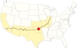
Location of Warwick on Route 66
At Warwick the average summer highs are 94.2°F or 34.6°C (July) and the lows are about 71°F (21.6°C). During winter (Jan) the average highs are 48.5°F (9.2°C) with average lows are below freezing: 25.6°F (-3.5°C).
The average rainfall is 36 inches (914 mm) with most rain falling during May, June and September: 5.4, 4 and 4.3 in respectively (135, 100 and 109 mm).
About 9.6 inches of snow (24 cm) fall during in winter.
Tornado risk
There are around 90 rainy days every year, and during summer there are more thunderstorms with hail risk and potential tornado formation.
Warwick is located in the "Tornado Alley and experiences about 10 Tornado watches every year.
Tornado Risk: read more about Tornado Risk along Route66.
Map of Route 66 alignment in Warwick

1936 Map, ODOT
Click on map to enlarge
Credits
See Route 66's alignment in this 1936 roadmap (click thumbnail for full size map).Route 66 ran by Wellston from 1926 till it was decertified in 1985.
This is the map with directions.
Route 66 Alignment near Warwick
Visit our pages with old maps and plenty of information of the old US66 roadway.
- Yukon to Clinton (next)
- Chandler to Yukon (Warwick's)
- Tulsa to Chandler (previous)
Route 66 landmarks & attractions
Sights in Warwick
Jack Rittenhouse does not mention Warwick in is Guidebook to US Highway 66, published in 1946. He wrote about two service stations, one is 2 miles west of Chandler (which has vanished without a trace), and another one seven miles from Chandler and four miles east of Wellston: "another gas station with grocery and garage. More gas at 79 mi."
Old Gas station
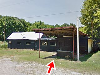
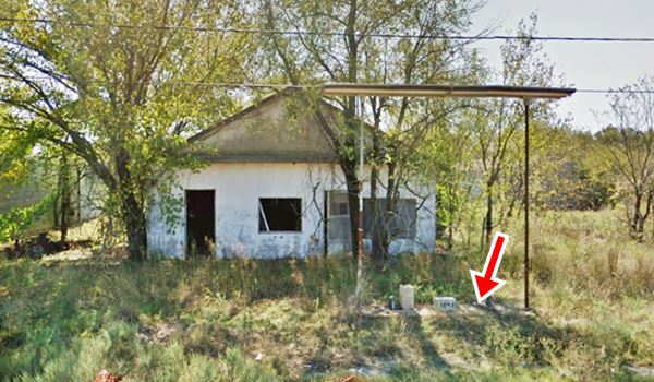
We will drive through Warwick coming from the east (Chandler). There is a 1950s gas station to the right, 5.6 mi. west of Chandler, just past the Ioway Casino.
It has a flat canopy above the remains of a single pump island (see red arrow in image). There is no way of knowing what brand it sold. There is no service bay area either.
Continue west for a mile, and as the highway curves to the SW just ahead, to your right is the historic Seaba Filling Station.
Seaba's Filling Station
On the entrance into Warwick, OK, on the NW corner of Route 66 and Commerce.
Listed in the National Register of Historic Places
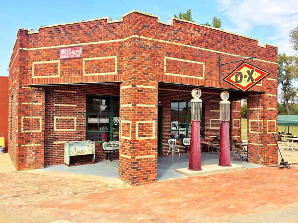
An original 1921 Service Station that predates Route 66 and is one hundred years old!
The service station is located on the eastern tip of the town of Warwick, on the western side of Route 66 as it curves around Warwick. It is five years older than the Mother Road, and was placed there before anyone even thought about Route 66.
At that time, the Ozark Trail was already 6 years old and had been absorbed by Oklahoma's State Highway NO. 7. Although it was not yet paved, it was an improved road and had a steady flow of traffic.
John Seaba saw an opportunity and built the service station next to Warwick. It served the local community and the highway travelers.
It sold "NevrNox" gasoline, which was a brand from Mid-Continent Oil Diamond DX. Later they shortened the name to DX. The company merged with Sun Ray, then with Sun Oil and finally became Sunoco.
Like most Filling Stations of the early 1920s, it sold gasoline and had a repair shop and garage to provide mechanical services for all types of vehicles.
Route 66 was designated in 1926 and its initial roadway was that of State Highway No.7 - the Ozark Trail. It was paved with asphalt in 1928 between Chandler and Wellston, passing right in front of Seaba's station.
The new highway brought even more customers and Seaba was purchasing Model T Fords and assembling them in his workshop.
In 1934 Seaba added an engine repair shop to rebuild connecting rods. By the late 1930s he had a staff of eighteen men working for him.
During World War II, gasoline rationing led to the closure of the filling station but the rebuilding of military trucks' engines kept the business going.
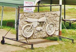
Seaba Repair shop was operational until the 1990s. Then it became an antique and gift shop which later closed. Another venture was a motorcycle museum, and it is still going strong.
The building
The original station was a polychrome brick building with five sides, these were open service bays held up by brick columns. Behind it was the workshop built in cheaper red brick with a gabled roof. Later two small buildings were added to the north and south sides, built in concrete block.
Only three of the original five sides remain open as you can see in the image below (red arrow marks the walled bay).
Then and Now view of Seaba (click on image for current street view)
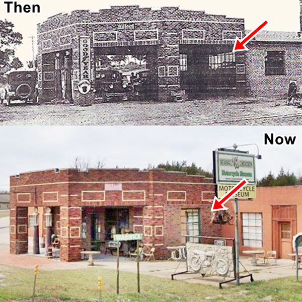
The flat roof was rimmed with white bricks and the columns and walls are decorated geometric shapes outlined by pale colored bricks.
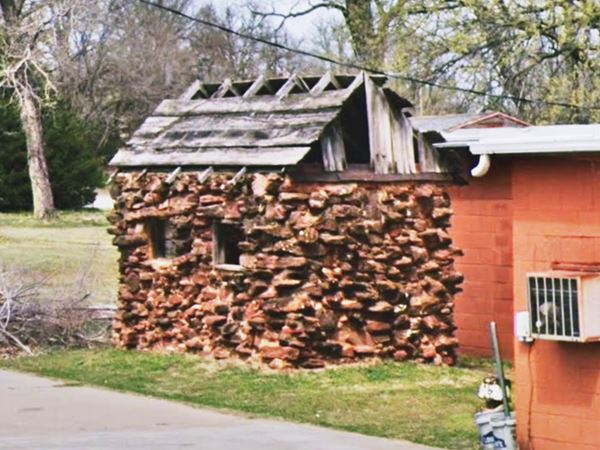
Don't miss its outhouse (pictured above), it was built in rock which catered to both women and men, with a modern restroom that included cast iron toilets.
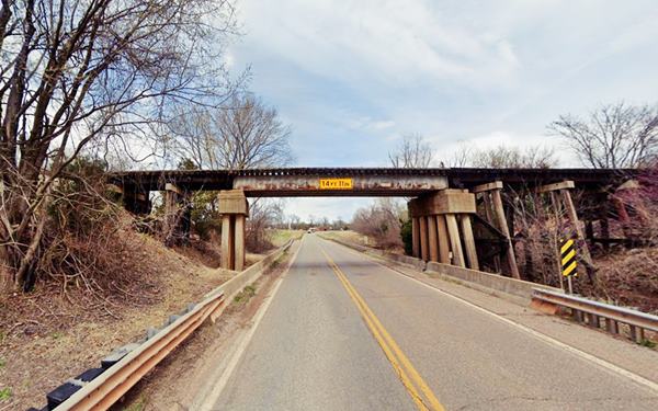
1928 Railroad Tressle
Route 66 continues with a SW course and curves around Warwick. Just ahead it passes under the railroad tressle built in 1928 and reconstructed in 1957. It carried the St. Louis and San Franciso railroad, and still carries traffic (now it is the Stillwater Central).
Ahead the highway curves again, now to the west and meets E0920 Rd. coming from the east, and Lincoln Ave. coming from the town, on the right. Here was a second railroad, whose tracks were lifted long ago, the Fort Smith and Western R.R. it ran with a NW-SE course along the eastern side of the Deep Fork River.
Another old filling station (in ruins)
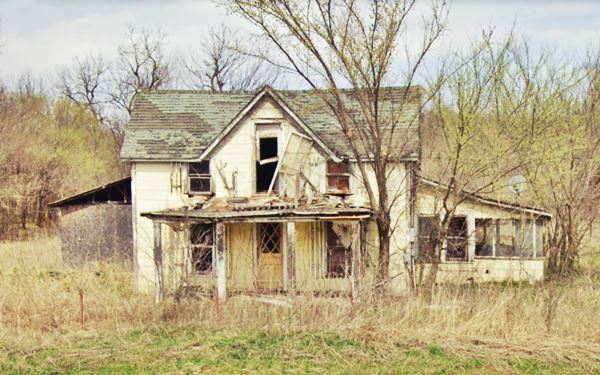
There is another gas station at the crossroads, E0920 Rd. was the preferred "1923 Blue Book" highway before State Hwy. 7 and Route 66 were created, it followed a longer alignment (see map) and according to Oklahoma DOT was the possible first Route 66 alignment, before it was paved in 1928.
The gas station has a visible pump island (red arrow), it looks like a home, with a gable roof and no service bays.
Route 66 alignment through Oklahoma
The Historic "Original" segments of Route 66 near Warwick
The original road that linked Oklahoma City to Chandler and Tulsa was the "Ozark Trails" highway network that was built in 1915-16.
Ozark Trail
The Lincoln county authorities saw that good highways allowed them to get their produce from the farms to the markets and were very active lobbying in the early 1910s for the Ozark Trail system to pass through the county. In 1916 the Trail was aligned through the Lincoln and it also passed next to Warwick.
Over the next few years, the state pooled resources with the counties and by 1924 the Ozark Trail had become Oklahoma Highway No. 7 which linked Oklahoma City with Miami Oklahoma.
It was a good highway and some segments were paved in the early 1920s (like the Ribbon Road). For this reason Route 66 was aligned along OK-7 when it was created in 1926.
But this was a rather primitive alignment, as it followed property lines, with plenty of right angle curves at the boundaries between properties. So when Route 66 was upgraded in 1930, the former zig-zag course of the "Ozark Trail" was bypassed and the newer paved alignment was shortened.
The segment west of Chandler, to Warwick and Wellston was paved in asphalt in 1928, and this was already the shorter alignment compared to the 1926 one. Also, the railroad south of Warwick was crossed using a trestle built in 1928, which remained in use until the roadway was widened in 1953.
Your road trip through Warwick ends here, you can drive west to Wellston.
Some sponsored content
> > Book your Hotel in Edmond


Credits
Banner image: Hackberry General Store, Hackberry, Arizona by Perla Eichenblat
Jack DeVere Rittenhouse, (1946). A Guide Book to Highway 66
seabastation.com (old, but official site)
Gerry Stanfill Greenfield, Warwick Encyclopedia of Oklahoma History and Culture


