Czech history and Flour Millers on US66
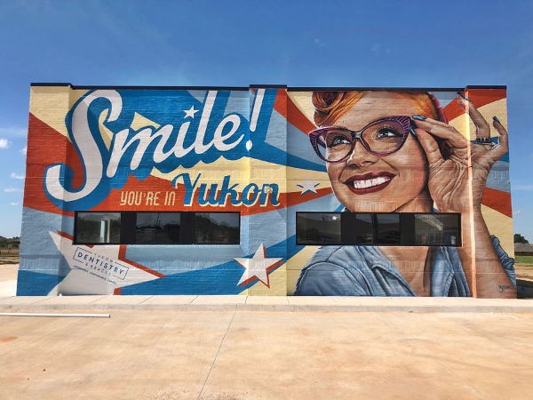
Mural "Smile you are in Yukon"
Index to this page

TheRoute-66.com is reader-supported. When you buy through links on our site, we may earn an affiliate commission at no additional cost to you.
About Yukon, Oklahoma
Facts, Trivia and useful information
Elevation: 1,289 ft (393 m) . Population: 22,709 (2010).
Time zone: Central (CST): UTC minus 6 hours. Summer (DST) CDT (UTC-5).
Yukon is a city located in Canadian County and is part of the Oklahoma City Metropolitan Area. Most residents work in Oklahoma City.
Oklahoma has been inhabited for at least 11,000 years. In nearby Luther there is a Paleo-Indian camp site dating back from 7,000 to 11,000 years ago.
The Native Americans that lived here when the town was established were the result of the U.S. government's resettlement policy that began in around 1820 and relocated the Indians to "uninhabited" land west of the Mississippi River.
Starting in 1859, The Cheyenne, Arapaho, Caddo and Wichita tribes were assigned the territory where Yukon is now located. Nevertheless, the last great battle between the Cheyenne, Arapaho and the United States Army took place in Canadian County.
But later the government decided to assimilate the natives and assigned individual tribe members a plot of 160 acres each and purchased the surplus land of each Reservation. This land was reserved for settlement by white Europeans & Americans.
As a consequence, the federal government created County Four in the new Oklahoma Territory, which was renamed after the 1889 "land run" as "Canadian County", after Canadian River which runs through it.
Land Run
A "Land Rush" or "Land Run" was a system by which those interested in staking a claim for a plot of land set off from a starting point and rode as fast as they could towards the land being "opended" to settlement. Once they reached it, they claimed their homestead on a "first come, first served basis". There were several "runs" in the early 1890s in Oklahoma.
A second land run took pace in 1892, expanding its territory.
The first town to be platted was Frisco, located 3 miles northwest of present day Yukon. There was a post office there from 1889 to 1903, it took its name form the St. Louis and San Francisco Railway ("Frisco") which was being built westwards from Guthrie towards the Pacific Ocean. But the tracks never reached Frisco (they went through Richland) which was abandoned in 1891 in favor of Yukon; it became a Ghost Town.
The name: Yukon
The town took its name from the post office, which in turn was named after Yukon River in Canada and Alaska, it is a Native American name "yu-kan-ah" meaning "Big River".
It is claimed that the town was named after the River due to the Canadian Klondike Gold Rush, but that event took place after 1896, so the story is probably not true.
In 1891 A. N. Spencer a businessman and Texas cattleman reached an agreement with another railroad, the Choctaw, Oklahoma and Gulf Railway and with two homesteaders (Minnie Taylor and Luther S. Morrison) to have the railroad pass through the townsite on Taylor and Morrison's property. The railway built the tracks and a station in 1891 and the residents of Frisco (pop. 1,000) moved to Yukon.
Around 1898 many Bohemians began arriving in Yukon, a flow which grew after the First World War (1918) when Bohemia was integrated into the new country of Czechoslovakia.
The Czech Capital of Oklahoma
The inflow of Bohemians into Yukon during the early 1900s, named "Czechs", led the town to be proclaimed "the Czech Capital of Oklahoma".
Visit the historic Czech Hall and enjoy the Annual Czech Day, held since 1966 in October.
Yukon began as a farming community and the main industry was the Yukon Mill and Grain Company, whose silos can be seen on Main Street.
The town incorporated in 1901 and soon had water works, sewerage and electricity (1910). A Interurban rail linked it to El Reno and Oklahoma City (1911 to 1940).
Route 66 was aligned through Yukon in 1926, and was paved that same year. It was Yukon's main throughfare and brought prosperity to its Business District. When I-40 was built further south, it drew diners, gasoline stations and business to its exit ramps.
Trivia: Grady the Cow
In 1949 national media took note of Grady, the cow who got stuck inside a storage silo on the Mach farm in Yukon.
The story went viral and after 4 days Grady got out of her tight situation. She became famous and as a local celebrity lived to the old age of 18.
Yukon is now a town whose residents commute to work at Oklahoma City, whose downtown is only 16 miles away.
Getting to Yukon
Heading east from Yukon down Route 66 are the towns of: Oklahoma City (15 mi.), Edmond (26 mi), Arcadia (35 mi.), Luther (43 mi) and Wellston (51 mi.)
To the west, are El Reno (14 mi.), Calumet (27 miles), Geary (38 miles), Bridgeport (40 mi) and Hydro (51 mi.)

Where to Stay
Book your hotel in Yukon
> > Book your Hotel room in Yukon
Lodging Near Yukon along Route 66
Heading East
- 15 mi. Oklahoma City
- 26 mi. Edmond
- 63 mi. Chandler
- 130 mi. Tulsa
Heading West
- 14 mi. El Reno
- 58 mi. Weatherford
- 104 mi. Clinton
- 101 mi. Elk City
- 119 mi. Sayre
Find your room in town, hotels in Yukon:
Booking.com>> There are several RV campgrounds close to Yukon.
The Weather in Yukon
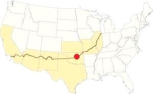
Location of Yukon on Route 66
The summers in central Oklahoma are hot and humid. However, winters are quite mild (but severe snowstorms can happen). During fall and spring there are frequent variations. During summer the prevailing winds blow from the south and southeast while during winter the north wind is the most common one. The average yearly temperature is around 61.5°F (16.4°C). The average mean during winter is 39.2 °F (4 °C), and the high and low are 48.5°F (9.2°C) and 25.6°F (-3.5°C) respectively.
About 8 inches of snow falls every year (20.3 cm) between December and March. During summer the average temperature is 83.0 °F (28.3 °C) and the average high and low are 94°F (34.5°C) and 71°F (21.5°C).
The average yearly rainfall is around 36.5 in. (928 mm). There are 85 rainy days per year with most rain falling during summer.
Thunderstorms are quite common during late spring and summer, and come with hail and strong winds. Some spawn tornadoes. Tornadoes can hit at any time during any season.
Tornado risk
Yukon is next to Oklahoma City, whose metro area is one of the most tornado-prone ones in the whole world: about 150 tornados have struk this area since 1890. Some of them were very strong (F5 on the Fujita scale, which is the maximum value). Yukon is located in the Oklahoma "Tornado Alley and experiences approximately 11 Tornado watches every year.
Tornado Risk: read more about Tornado Risk along Route66.
Map of Route 66 in Yukon
Historic Route 66 in Yukon
The first highway to link Yukon with Oklahoma City was Oklahoma State Highway No. 3. It was was paved in Portland concrete in 1923 from 39th and Penn in Oklahoma City to the Lake Overholser Bridge, east of Yukon.
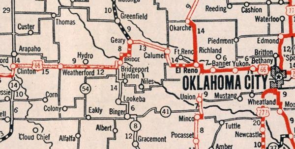
Lake Overholser Bridge
Listed in the National Register of Historic Places
The bridge is very close to Yukon, but forms part of Oklahoma city. It has two types of steel trusses: each end is a camelback Warren Pony Truss while the four central spans are Parker Through Trusses. It was built between 1924 and 1925, predating Route 66 which later incorporated it into its alignment for over three decades. It was repaired and restored in 2001, and once again reopened to traffic. The original 1926 to 1958 Route 66 crossed the bridge and then went west bordering the north shore of the lake. It then went along NW 36th St. and Lakeshore Drive. It followed the Interurban Trolley line that linked Yukon to OKC, and that is why it curves slightly south at S. Yukon Parkway; see this map of the alignment to this point.
The road in those days followed a different alignment to that used by current OK-66 (Route 66). The modern highway was realigned further north (39th St. Expressway) in 1958. The map (click on it to enlarge) shows these old and new alignments east of Yukon above Lake Overholser.
In 1949 the road took its current configuration west of S. Yukon Parkway, with four divided lanes, which were continued eastwards in the 1958 upgrade. Once in Yukon, Route 66 became the Main St. as a 4-lane non-divided avenue, to Garth Brooks Blvd. where once again it became a 2-lane road. West of Yukon the road was widened to a four-lane highway in 1951.
Route 66 Alignment near Yukon
With maps old maps and all the details along the way.
- Yukon to Clinton (next)
- Chandler to Yukon (previous)
Route 66 landmarks & attractions in Yukon
Sights in Yukon
Sponsored content
Historic Context
Jack DeVere Rittenhouse described the whole of US 66 in his 1946 work "Guide Book to Highway 66". He also included Yukon.
YUKON...garages: Barret, Ford, Dependable; courts: Star, Yukon, Valley; stores; cafes... as you enter Yukon from the east, you pass the Dobry Flour Mills and other mills. Jack DeVere Rittenhouse, 1946
We will begin our tour on the eastern side of Yukon and head west.
Smile You Are In Yukon Mural
The mural is the work of Carlos Barbosa, painted on the southern wall of Yukon Dentistry, 901 E Main St to your right, on the north side of Route 66
(see the mural's image at the top of this page). It depicts a smiling woman with glasses and the words "Smile You Are In Yukon",
has a 1950s air to it.
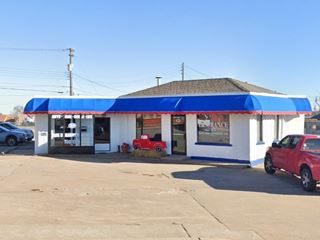
Head west and to your left, on the south side of Route 66 is a former motel.
Chateau Inn Motel & Restaurant
To your left, at 10 E Main St. Still standing with its peaked gable roof, but without its great neon sign or swimming pool. Now it is the "Guest Inn". Its postcard below states "West Edge Okla. City... Luxury Rooms with Color TV, Radio, Background Music.. Beautiful Courtyard and Heated Pool".
> > You can Book a Room in the Guest Inn motel
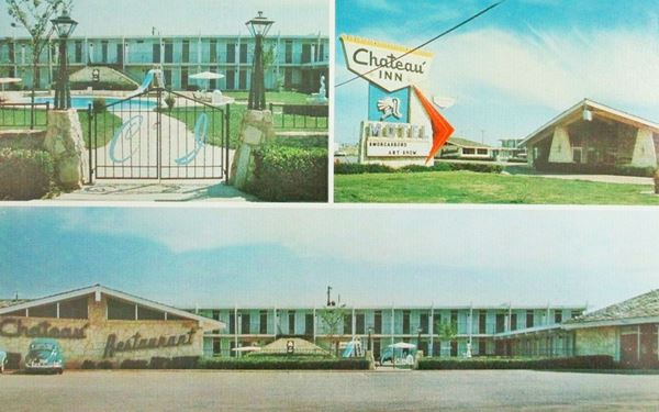
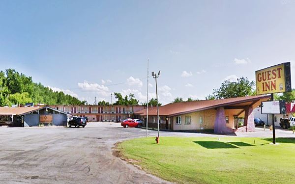

Fat Elvis Sign Yukon . A. Whittall
On the next block, to your left is what was the "Fat Elvis" (or "ElvUS") restaurant.
Fat Elvis
At 4 E Main St. Closed for good around 2017, now it is a used car dealer. At one time it was run by Darin Thrasher, an Elvis impersonator, and sold great onion burgers. It changed its name from "Elvis" to "ElvU.S" probably due to some legal issue around 2014.
Before that date it was known as Sid's Diner and was also operated by Thrasher.
The image shows the last "Fat ElvUS" sign (street view) inset against the
older "Fat Elvis" sign (street view). Now still standing, painted yellow, with the
name of the dealership "S&A Motors" (street view Feb 2021).
It was contemporary with Sid's Diner in El Reno, but we haven't yet found the link between them.
Old Gas Station
Across the street, on the SW corner of Cornwell Dr. and Route 66 is a 1950s gas station, with three service bays, glassed corner office and a flat canopy over twin pump islands. See its street view, also a used car dealership.
Ahead the giant silos loom both left and right. To your right is the MFC Farmer's Co-Op grain elevator on the north side of US 66. To the left is the "Yukon Mill" landmark.
Yukon Mill
3rd. St. and Main St. Yukon. The "Yukon Mill and Grain Company" began in 1893 as a small business operating a grain elevator and mill. It was acquired around 1903 by John F. and Frank L. Kroutil with A. F. Dobry, who expanded the company. By 1915 it was exporting grain. The plant could mill 2,000 barrels of flour per day in the 1930s.
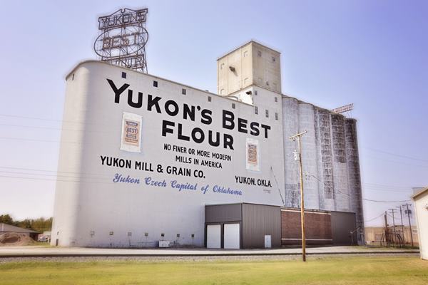
The Dobrys sold their part to the Krotils and opened a second mill (Dobry Mills) which operated separately for years until they were acquired by bigger players in the market. Yukon was purchased by Shawnee Mills which in turn was acquired in 1972 by Mid-Continent. Sinc they had already bought Dobry Mills, both were reunited again.
It is still in operation on Yukon's Main Street (Route 66) next to the railroad tracks.
The Millers
The students of Yukon High School are known as "Millers", and their mascot is the tough "The Miller Man", in red overalls.
The side of the elevator silos, painted white, read: "Yukon's Best Flour, no finer or more modern mills in America. Yukon Mill & Grain Co. - Yukon, OK Yukon Czech Capital of Oklahoma" The 42 x 55 foot sign atop the elevator lights up at night using energy-saving LEDs and announces "Yukon's Best Flour"
Yukon's Best Mural
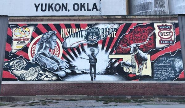
Facing Route 66, at the base of the flour mill elevators. The mural is the work of Carlos Barboza and was commissioned by a local group called "Friends of Yukon's Best". It depicts typical Yukon figures such as a Czech Queen, a longhorn on Chisholm's Trail, Route 66 with its shield, flour, the Miller man mascot and Garth Brooks with his guitar (Brooks, a country singer and songwriter is the city's most famous son).
Take a right along North 3rd street to visit two museums.
Yukon's Best Railroad Museum
One block north, to your left, you will see the restored railroad cars. Apart from them, it has historical information about the railroad.
Yukon's Historical Society Farm Museum
On the NW corner of 3rd and Cedar St. next to the RR museum, it displays farming implements and artifacts from the early days of Yukon. See the "old" tractors.
Return to Route 66 and turn right. Ahead are the railroad tracks, a grade crossing ever since US66 was created. Originally another set of tracks ran across the highway, the "trolley".
Interurban Trolley line

1943 Sanborn map, Yukon OK. Click thumbnail to enlarge map. Credits
The thumbnail map (click on image to enlarge) was published by Sanborn Map Co. in 1943. shows the area where Route 66 crosses the tracks. The highway runs left to right, the tracks diagonally across the image. You can see the now gone Rock Island Railroad depot (yellow building) on the north side of the highway, and to the left, also in yellow, the "Interurban Depot".
The "interurban" was an electric streetcar. They were built in wood and looked like regular railroad passenger cars, but were powered by overhead electric lines.
They linked towns around Oklahoma City like Norman, Guthrie, Edmond, Yukon and El Reno (and also in the Miami, Commerce, Baxter Springs, Galena, Joplin area in the Oklahoma, Kansas and Missouri tri-state region). After World War II, with the end of rationing and growing auto mobility, the trolleys disappeared. In Oklahoma City, it shut down in 1947.
The depot is still there, just north of the highway, behind the "Oklahoma Centennial monument" with a longhorn steer and a sign next to it commemorating the 100 years of Yukon (1907-2007).
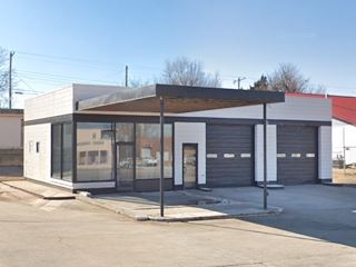
1950s Phillips 66
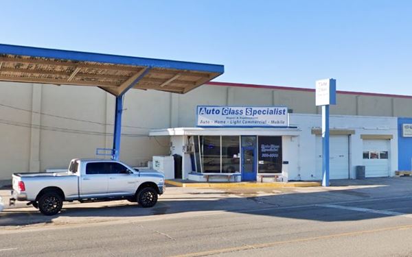
After crossing the tracks, there are three former gas stations, and the three of them appear in the 1943 Sanborn map. To your left, on the south side of Main St. is what appears to be a Phillips 66 station. Located at 302 Main St. It appears in the 1943 Sandborn map (above) with an angled office on its eastern side as a blue building. It is built in blocks and has two service bays. The plate glass office with upward slanted windows is a typical Phillips 66 feature in the late 1950s and the 1960s. It has a detached butterfly canopy and the office itself is placed at an angle probably due to the narrow piece of land on which it was built. Since the 1990s it has been occupied by Yukon Auto Glass.
1940s Gas Station
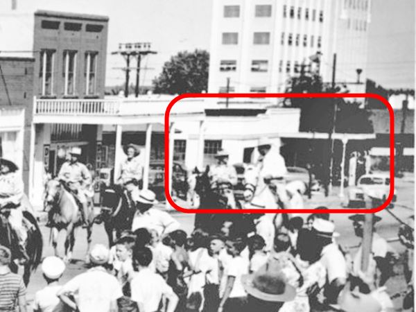
Facing it, on the north side is another filling station with an oblong box shape, and two service bays to the left. A flat canopy extends over a single pump island. You can see it in this photo published in 1947, in the red box to the right (see the same view nowadays).
It has no signs in the picture so we can't tell which brand it sold.
It also appears on the upper part of the Sandborn map of 1943 in blue with its flat canopy in yellow as "Filling Sta".
Filling Station
Next to it, on the corner is the third gas station that appeared in the 1943 map. The brick building with a hipped roof is angled at 45° facing the corner of Main and N 4th St. and you can see the outline of the pump island in the concrete apron in front of it. You can see it partly concealed by the second floor balcony, to the left of the red rectangle in the 1947 picture further up.
Chisholm Trail Mural
The mural pictured above, faces the corner station, on the eastern wall of N 4th Street. It commemorates the feat of Jesse Chisholm an Oklahoman with Cherokee blood, who laid down a trail from the Arkansas River in Kansas to the Canadian River in Oklahoma, it was later used by ranchers to drive their cattle herds up from Texas to Abilene Kansas railroad yards for shipment to the Eastern US markets. The trail was named after him.
Mulvey Mercantile
Listed in the National Register of Historic Places - State Historic site
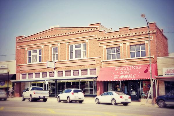
Around the corner from the mural, on the same block, at 425 W. Main. The two-story building was built in red brick in 1904, the words "Mulvey Mercantile" are inlaid with
black tiles against a white tile setting in the entry area.
The facade has ten clerestories that admit light. The red brick is inlaid with lighter colored outlines that give the building character.
Mulvey Mercantile was established in 1893 and sold hardware, farm appliances, and dry goods. It was the largest store in town until The Great Depression led to its bankruptcy in the 1930s.
Route 66 Crosswalk

Crosswalk, Yukon OK. Credits
On the next street, half way down the block to your left (10 S 5th St.) is the Crosswalk, a colorful depiction of Yukon's icons (the Millers, Garth Brooks, Flour, the Czech heritage and more). It links public parking behind City Gall with the Main Street area.
Streamline Moderne Station
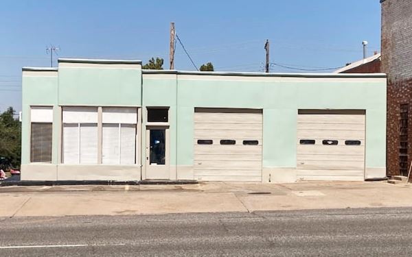
On the NE corner of N 6th and Main St. at 545 Main, to your right you will see another ancient gas station.
Freshly repainted in 2021, it has two service bays to the right, and a corner office to the left. The central part of the office, with the narrow windows protrudes from the main line of the building and give it a distinct "Streamline Moderne" look. It has two doors on its western facade (access to the restrooms?) and a flat roof with a higher parapet over the bay windows.
It appears in the 1943 Sandborn map too (as "Fllg. Sta").
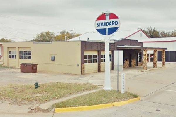
Standard station
Head west, on the NE corner of Main and N 9th is a former gas station. It appears on the 1947 (Sanborn map (page 3). The stone and wood faced building has two service bays, a flat canopy supported by three thick stone pillars over the single pump island. The Standard sign is a classic one.
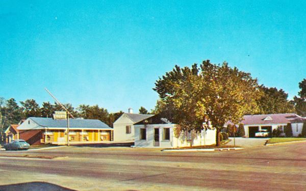
Yukon Courts
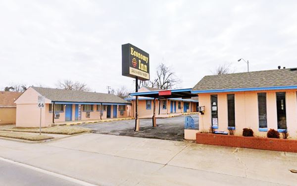
Across Route 66 on the SE corner, is the Economy Inn motel. It has an L-shape layout around the office that is located on the corner. It appears as a "Tourist Camp" in the Sanborn map.
It was the "Yukon Courts" mentioned by Rittenhouse, later the "Yukon Motel" with a great neon sign (now gone) but with the same wrought iron columns on the porch, and gable roofed units.
Another gas station (Ross Service)
Across S 9th St., on the SW corner, is another old gas station, "Ross Service". It has a "stepped" design with the service bays higher than the corner office. It lacks a canopy and pumps. The office has a window wall with stacked windows & horizontal muntins on one side, and large plate glass windows facing US66.
New Motel
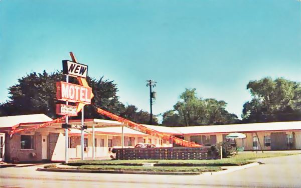
Next to Ross, at 920 W Main, to your left, on the south side of Route 66 is the "New Motel". It has a U-shape layout with the office on the eastern side. In its 1960s postcard we can see the same distribution; the place is unchanged (see the same hollow concrete block wall on the lawn!), except for the loss of its great neon sign (see the "Then and Now" pictures above and below).
Star Courts
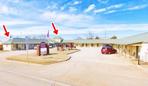
On the north side of Route 66, opposite the New Motel (at 925 Main) is another classic US66 motel, it appears in the 1943 Sanborn map as a Tourist Camp and was mentioned by Rittenhouse. It has the same two story building in the NW corner (red arrow). It has maintained its original U-shaped layout and the small gables in the tips of its hipped roof (red arrow). Now it is "El Dechado" an apartment complex.
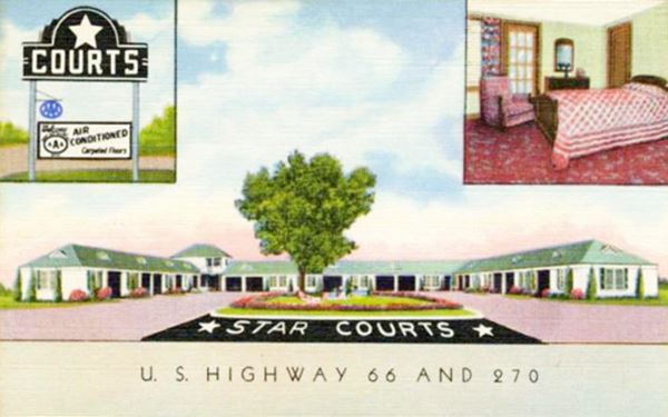
The postcard says "18 Beautiful units with tub or shower -some with kitchenettes, air conditioned and carpeted, Beauty Rest Mattresses."
Head west and you will reach the last classic gas station in Yukon, to your left. It is an oblong box station from the 1950s, and has a flat canopy and two service bays. At one time the area under the canopy had been converted into a room. Now it has been removed yet you can still see the raised floor next to the pump island.
This is the end of your Route 66 City Tour of Yukon, head west to visit El Reno, or take a tour near Yukon.
Tours in Yukon
Czech Hall
205 N. Czech Hall Road, Yukon, OK.
Listed in the National Register of Historic Places - State Historic site
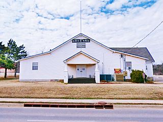
Czech presence in Yukon is evident at the historic Jan Zizka Lodge Number 67, popularly known as "Czech Hall", located two miles south of Main Street and 0.6 mi. south of I-40. the Hall is on the right side of the road, map with directions
People have been dancing here (Czech dances) every Saturday night since 1925. The place is open to anyone (there is an admission fee for adults). It is the largest dance hall in Oklahoma.
The Hall, which is also known as Bohemian Hall was first built in 1899 by the Bohemian settlers (the current building replaced the original one in 1925).
The Czech migrants were members of Sokol Karel Havlicek Lodge and Western Fraternal Life Association Lodge Jan Zizka No. 67., and used it for their social and musical events: weddings, dances, family gatherings.
Chisholm Trail Park Marker
On the north side of W. Vandament just west of Garth Brooks Boulevard
Historic Oklahoma Marker
The park is great for running and walking and is also the venue for Yukon's Concerts in the Park and the July 4th celebration. Visit its look-out peak and the "marker of the Chisholm Trail".
Cowboy Camp Springs
To the north of the fence that is behind the "Chisholm Trail Marker" is a pond (access it from Garth Brooks Blvd. just north of W. Vandament). This pond was a very important watering hole used by the cowboys who drove the cattle along the Trail.
It originated in two natural springs and was well known to the Indians and the buffalo that lived here. It provided clean water for the cowboy campsite.
Cattle were watered at Canadian River, to the north of the campsite.
The current pond was built in the 1930s by the Works Program Administration and the Civilian Conservation Corps.
Chisholm Trail Crawfish Festival
Held in the park, on the homestead that was the Kirkpatrick Family Farm (1001 S Garth Brooks Blvd.) it is also the venue for an Easter Festival, more details a the Chisholm Trail website www.chisholmtrail.org
Annual Czech Day
Held during October since 1966. Full details at www.czechfestivaloklahoma.com website.
Some sponsored content
> > Book your Hotel in Yukon


Credits
Banner image: Hackberry General Store, Hackberry, Arizona by Perla Eichenblat
Jack DeVere Rittenhouse, (1946). A Guide Book to Highway 66.
Cynthia Savage, Yukon. Encyclopedia of Oklahoma History and Culture, www.okhistory.org
Town's Website www.cityofyukon.gov.
Yukon Chamber of Commerce


