
All about the Weather along the Mother Road
Table of Contents
Index to this page:
- Weather, Seasons and Route 66
- Detailed Seasonal Weather info
- Rainfall
- Temperatures
- Snowfall on Route 66
- Weather in each town on Route 66
- Tornadoes along Route 66
Weather, Seasons and Route 66
Facts and useful weather information to plan your trip
Best time for your Road Trip
The time of the year you choose for your Route 66 road trip is very important.
As a road trip vacation, driving Route 66 is an important part of your experience, another aspect are the outdoor activites along the way, that include visiting National Parks (Grand Canyon, Petrified Forest Nat. Parks), sightseeing and taking photos of classic motels and service stations and visiting its landmarks and attractions.
Weather plays a very important role in your driving experience and your holidays (imagine rains, unexpected snowfall, or scorching heat).
Your Route 66 roadtrip will be a pleasant adventure if the weather is good.
The best season for your Route 66 Road Trip is the period of the year that spans from the middle of spring until mid-fall, including summer (May to October).
If you travel earlier (January to April), or later (November and December), you run the risk of encountering snow and cold weather.
Bear in mind that US 66 runs all the way from Chicago in the North of the US to balmy Los Angeles in the Southwest, so it crosses several climate zones.
Tornados (visit our page on tornadoes) can and do take place east of the Rocky Mountains during any month of the year, but they are less frequent in winter and more common during spring and early summer (March to June). More on Tornados below.
Cold weather and low temperatures can be encountered even in summer. In the West, there is a large swing between day time and night time temperatures. Carry a light jacket with you, even in summer. Expect snow during fall too!
Snow on Route 66, winter 2019

Heat and summer storms: Summer can be pretty warm in the Western areas of Route 66, but that is no problem with air-conditioned cars, motels, hotels, restaurants and diners. Just dress comfortably for the hot weather and keep hydrated.
Rain. Should be expected and planned for, summer is the monsoon period in the Southwestern US; take rain gear with you, don't let it spoil your outdoor activities during your trip.
Thunderstorm looms over the Mojave in California.

The day we took the picture shown above, on July 28, 2013 it poured; rain fell like cats and dogs and visibility was virtually zero. Traffic slowed down and even stopped on I-40, everyone was pulling over onto the shoulder. We had to take a detour (via US 95 through Laughling Nevada and US93) to reach Kingman as the freeway was flooded east of Needles!
Weather in Each Town along Route 66
In each of our "Town" web pages, we include a summary of the town's weather and the current forecast.
You can also check some official websites with weather alerts, forecasts and snow ⁄ rainfall information:
- State of the Climate: National Climatic Data Center (NCDC)
- National Weather Service: Forecasts & alerts
Detailed Seasonal Weather info on US66

Map Key. Color code for the rainfall in inches and mm
1. Rainfall along route 66
In the maps below, we show the alignment of Route 66 with a black line linking Chicago in the east with Los Angeles in the west.
There is a clear gradient with a decreasing trend of rainfall as you head west once you reach central Oklahoma.
There is less rainfall in the Southwest, and it reaches its lowest values (less than 5 in. - 12 cm per year) in the Mojave Desert region in California and also in Western Arizona.
Map showing Average U.S. rainfall. Route 66 is shown in black.

A rainy winter day on Route 66.

2. The Temperatures along Route 66
The following maps show the average high and low temperatures for each season.
Route 66's alignment is marked with the black line running across the maps. The data is from the NOAA.
Summer

Table converting Fahrenheit to Centigrade. Equivalent temperatures
Summer is very hot along the whole length of Route 66.
This hot period coincides with the high season due to summer school break ⁄ summer holidays period. So expect crowds at key attractions and tight room availability at hotels, so book your hotel room early!
Central USA due to its distance from the sea has a continental climate so temperatures in Illinois and Missouri are high despite their northern latitude.
In the Southwest summer is scorching, specially in the western part of Arizona (beyond the mountains in Williams and Flagstaff), and in California's Mojave Desert.
Summer: Average High Temperatures - July

Adapted by from NOAA data
Summer's Average low Temperatures - July

A. Whittall
Fall (Autumn)
Temperature drops during Fall. With average lows in the eastern part of Route 66 (Illinois, Missouri, Kansas, Oklahoma and Texas) in the 40s (4.5-10°C).
Further west in the Rocky Mountains (New Mexico, eastern Arizona) the average lows drops even further into the 30s (freezing temperatures).
Average Fall High Temperatures - October

A. Whittall

A. Whittall
Winter
Winter is not a good time for roadtripping along US 66. It is very cold in its northeastern Illinois segment and in the Rocky Mountains (NM and AZ) with average lows in the 10s (-12 to -7°C).
Missouri, Kansas, Oklahoma and Texas are also cold with lows in the 20s (-6.5 to -1.1°C). It warms up as you enter California.
Winter's Average High Temperatures - January

A. Whittall
Winter's Average Low Temperatures - January

A. Whittall
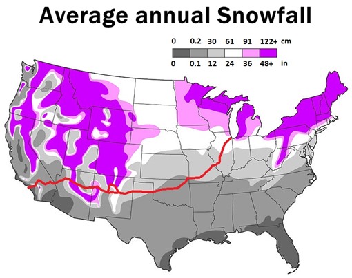
Snow on Route 66
Excluding Los Angeles, during winter you will encounter snow on Route 66.
The average snowfall on the Mother Road peaks in northern Illinois (+24 in. - 61cm) and in the Rocky Mountains from Grants to Williams, where snowfall can exceed 48 inches (122 cm) on average each year.
Average annual Snowfall along Route 66 (alignment shown in red):
Spring
Spring brings blooms, and nicer weather to Route 66, it is also less crowded and hotels can be booked at reasonable rates.
The climate resembles fall, but cooler and snow may fall during early spring.
>> learn more about When is the best time to drive Route 66?
Spring's Average High Temperatures - April

A. Whittall
Spring's Average Low Temperatures - April

Weather in each town on Route 66
Example of the information you will find for each town.
Weather in each town along Route 66
For each town along Route 66 we provide a overview of its weather and its current weather forecast.
Check this example: Weather in Santa Monica California with a description of its historical weather conditions.
Each "town" page also includes a weather widget with the current forecast for that town (see the image).
>> See the List with all Route 66 towns
Weather: State by State
An overview of the climate in each State
The weather along Route 66, state by state, from west to east, plus the highs and lows in one important town or city in each state.
California ¦ Arizona ¦ New Mexico ¦ Texas ¦ Oklahoma ¦ Kansas ¦ Missouri Illinois
California
Los Angeles
Average High ⁄ Low Temperatures in Winter and Summer:
Jan.: 71 ⁄ 49 °F (22 ⁄ 9 °C)
Jul.: 92 ⁄ 68 °F (33 ⁄ 19 °C)

Sunburn
Sunburn: how to avoid it, treat it, and its long term risks. Learn about sunscreen, protective clothing, UVA and UVB rays and how to shield your skin.
This state has a Mediterranean climate along its coast and southern region, with dry summers and rainy winters.
As you move inland, beyond the coastal hills, the moderating effect of the Ocean decreases, so the summer temperatures are higher by about 25°F (14°C) and the winter temperatures are around 7°F lower (4°C).
A phenomenon known as the Mexican Monsoon or "Southwest Monsoon" funnels moisture from the Ocean (The Pacific and also the Gulf of Mexico) into the desert region of the Southwest causing strong thunderstorms with intense downpour over the mountains.
Arizona
The Snowiest City in the US is on Route 66!
Flagstaff
Average High ⁄ Low Temperatures in Winter and Summer:
Jan.: 43 ⁄ 17 °F (6 ⁄ -8 °C)
Jul.: 89 ⁄ 60 °F (32 ⁄ 16 °C)
The city with most snowfall in the whole of the US
Flagstaff AZ, on Route 66, has an average yearly snowfall of 100.3 inches (254.76 cm) and is one of the snowiest incorporated cities in all of the United States.
The region through which Route 66 runs, crosses the dry and arid or semi-arid regions of the state, which have a Semiarid Steppe Climate. This northern part is cooler than the southern areas of Arizona.
The rainy season takes place during summer (when the moisture from the Pacific and Gulf of Mexico is blown across the state), causing thunderstorms. Early winter is also a rainy period.
Snow, despite being hot in summer, the winters are cold and snow is frequent. At any time between November and late March, storm systems moving in from the Pacific Ocean can cause heavy snow in the high mountainous areas of central and Northern Arizona. The Grand Canyon's South rim receives 60 inches (1.3 m) of snow in winter, its North rim 144 inches (3.2 m).
The area with highest rainfall is the high altitude region around Flagstaff, it falls off to the east and west of Flagstaf.
The area with least rainfall along U.S. 66 is between Oatman and the Colorado River in Arizona.
The average relative humidity is low, and is highest in Flagstaff: 55%
Altitude and dryness causes large variations in temperature between day and night, even in summer.
New Mexico
Albuquerque
Average High ⁄ Low Temperatures in Winter and Summer:
Jan.: 47 ⁄ 24 °F (8 ⁄ -4 °C)
Jul.: 92 ⁄ 65 °F (33 ⁄ 18 °C)

Dehydration
Excessive loss of body fluids can seriously harm you. Know the signs, causes, and symptoms of dehydration. How to prevent it and treat it.
Along Route 66 in the higher parts of New Mexico, summer temperatures are moderated by the altitude, averaging 70°F (26°C), but in other parts of the state, the temperature in July can exceed 100°F (38°C).
The state is arid or semi-arid and very dry: average rainfall is around 14 inches (350 mm) yearly.
It snows across the state in winter, especially in the higher northern mountains. Albuquerque averages around 2 inches of snow monthly in winter.
Bear in mind that altitude and dryness causes large swings between day and night temperatures, even in summer.
Texas
Amarillo
Average High ⁄ Low Temperatures in Winter and Summer:
Jan.: 49 ⁄ 23 °F (9 ⁄ -5 °C)
Jul.: 91 ⁄ 65 °F (33 ⁄ 18 °C)
This area has a Semiarid Steppe Climate, and is rather dry but very sunny: rainfall averages 20 in per year (500 mm). Summer highs (June through September) average over 90°F (30°C) and the average lows are about 65°F (19°C). During winter the highs average 50°F (10°C) with lows below freezing: 25°F (-4°C).
It can snow in the Texas Panhandle at any time between September and May (first snow is usually on the first week of December). The high altitude causes greater snowfall than locations further east: 17” per year on average (with peaks of about 40”) - 43 to 102 cm.
During winter, cold winds from the north can drop the temperatures below freezing and provoke blizzard conditions.
Sunny and Windy Texas
The western region of US 66 corridor through Texas is among the windiest in the U.S., but it is also among the sunniest regions in America.
Thunderstorms are frequent in summer and Tornadoes are predominant during the period between April and June (Tornadoes on Route 66).
Oklahoma
Oklahoma City
Average High ⁄ Low Temperatures in Winter and Summer:
Jan.: 50 ⁄ 29 °F (10 ⁄ -29 °C)
Jul.: 94 ⁄ 72 °F (34 ⁄ 22 °C)
The open flat region of Oklahoma is subjected to the influence of the humid air from the Gulf of Mexico, the dry and hot air from the west and the cold and dry air from Canada. This combination leads to fluctuating and extreme climatic conditions: Oklahoma is located on the "Tornado Alley and is hit by an average of 62 tornados each year between April and June, which is among the highest in the whole World.
The climate is humid and subtropical in its central regions.
It rains all year, with higher precipitation during late spring and summer (around 5 inches 13 cm), with thunderstorms during this period.
Summers are hot and winters mild (but as mentioned above, cold spells with snow or freezing rain are common too). Oklahoma City experiences around 3 in. of snow monthly in winter.
Kansas
Southeastern Kansas
Average High ⁄ Low Temperatures in Winter and Summer:
Jan.: 38 ⁄ 17 °F (3 ⁄ -8 °C)
Jul.: 90 ⁄ 67 °F (32 ⁄ 19 °C)

10 Reasons Road Trips
are Good For You
Road trips have many benefits; they enhance your wellbeing by opening your mind, making memories, slowing your pace, bringing spontaneity and more! Learn the top ten reasons why going on a road trip is good for you
Rainfall is more common in summer and spring and highest along the corridor of US 66 (with 47 inches or 1,200 mm per year). Summers are very hot and humid and winters oscillate between very cold spells and warm periods.
The southeastern area (where Route 66 crosses the state) has a subtropical climate
Snowfall increases from southeast to northwest. The southern parts see around 5 inches (12 cm) of snow in winter, and enjoy over 200 frost-free days per year.
Kansas is the 9th or 10th sunniest state. Nevertheless, during spring and early summer thunderstorms and severe weather are common, and these can originate tornadoes, flash flooding, heavy winds and large hail.
There are around 50 tornadoes per year in Kansas (read about Tornadoes & Route 66).
Missouri
Saint Louis
Average High ⁄ Low Temperatures in Winter and Summer:
Jan.: 38 ⁄ 21 °F (3 ⁄ -6 °C)
Jul.: 90 ⁄ 71 °F (32 ⁄ 22 °C)
Being a relatively flat state, it is influenced by the cold winds from the Arctic and the hot and humid air from the Gulf of Mexico. The climate is humid and continental with warm summers.
Route 66 cuts across the state in a diagonal course from its southwestern tip to its central-eastern region at St. Louis.
Wide temperature fluctuations are common but in general summers are hot and winters long and cold.
It rains more frequently in spring and summer; yearly rainfall is around 45 inches - 1140 mm. This is also the period with most tornadoes; around 35 tornadoes strike Missouri every year.
Thunderstorms and even tropical cyclones can take place during summer.
Winters are drier; northwesterly winds prevail and snowfall ranges from 10 to 20 inches (25 - 51 cm).
Illinois
Chicago
Average High ⁄ Low Temperatures in Winter and Summer:
Jan.: 31 ⁄ 16 °F (-1 ⁄ -9 °C)
Jul. : 84 ⁄ 64 °F (29 ⁄ 18 °C)
Its central location gives Illinois a continental climate with warm humid summers and cold winters.
Route 66 cuts across the state from the southwest to the northeast, along which rainfall decreases from around 48 to 35 inches (1,200 to 890 mm) and snowfall increases from around 14 inches (36 cm) to over 38 inches (97 cm) in Chicago.
May and June are the wettest months and thunderstorms take place during spring and summer, and can provoke tornadoes (35 tornadoes strike Illinois every year, between April and June).
Summers are hot (the 1995 Chicago heat wave had temperatures of 106°F - 41°C), and winters can be very cold with abrupt drops in temperature.
Tornadoes
Tornado (n.). Derived from ternado a word used by sailors for strong windy thunderstorms. Probably originating from the Spanish words tronada,
"thunderstorm", tronar "thunder" and even tornar, "to turn or rotate" in both Spanish and Portuguese. It was also known as tornatho, turnado and tornathe.
Plural: Tornado or Tornadoes.
Chances of encountering a Tornado along Route 66
The U.S. has about 100,000 thunderstorms a year and less than one percent produce a tornado. So the odds are against encountering one while driving along Route 66.
The tornado frequency along Route 66 (see map below) is quite variable: west of Albuquerque, NM, there are, on average, 0 tornado watches per year. In Oklahoma there are 10, and in the eastern Texas Panhandle, SE Kansas, Missouri and central Illinois between 5 and 8.
The weighted average frequency for the whole route is: 1.26%. That means that the probability of a tornado watch being issued on any given day is only 1.26% or, to put it differently, tornado watches are issued, on average, during 4.6 days every year.
A Tornado forming in Texas

The area with highest tornado frequencies only has less than one tornado watch per month. Slim chances of encountering a tornado during your journey along Route 66.
>> Read more about Tornados on Route 66
Map of Tornado Frequency in the US
Tornado Watches map showing the average number of tornado watches per year (1993-2012)
Twenty year tornado watch frequency map

Click to see Large size Map

Sponsored Content
>> Book your Hotel in Santa Monica
Credits and Further Reading
Banner image: Hackberry General Store, Hackberry, AZ by Perla Eichenblat