Route 66's History
Index to this page
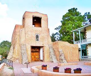
The Oldest Church in the US, San Miguel Mission. Santa Fe NM
A. Whittall
- History of Route 66
- The Ancient Roots of Route 66
- The United States Expands West
- The Automobile, a new age
- Birth of the US Highway System
- Route 66 is Born
- First years of Route 66
- The Great Depression & US66
- Grapes of Wrath and the Mother Road
- The Western Terminus of Route 66
- Politics and U.S. 66
- Route 66 during World War II
- Golden Age: Post War Years on Route 66
- Decline and demise: Route 66 Slowly Fading Away
- Route 66 Returns
The History of Route 66
The "Mother Road" was born from the need of a nation to move about, for trade, work, and leisure. It was initially a hodgepodge of different roads, most of them dirt tracks, linked together by an incipient Federal highway system.
From such humble origins, it became an icon of America and an international symbol of Americana.
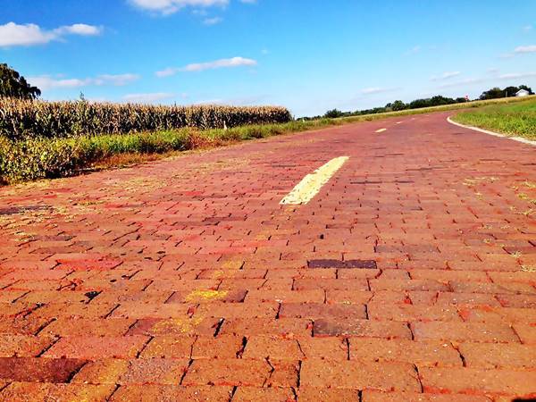
The Brick Paved Route 66 in Illinois
The Ancient Roots of Route 66
The history of Route 66 began long before there were cars or even horses and carts in America. It began with the first people to reach the New World some 15,000 years ago.
Prehistoric and Native American Trails
The first people to reach America 15,000 years ago made the first trails across the land. The bison tracks in the prairies and animal trails in the woods were used by these Paleoindians.
The Indians used them as foot trails known as "traces" like the Old Indian Trace in Elkhart Illinois by Route 66.
Fur trappers in the 1700s and the first European pioneers in the early 1800s used them to reach the Mississippi River. Stagecoaches and later the railroads were aligned along them in the 1800s.
The Spanish colonies in New Mexico and California built their roads too: the Santa Fe Trail and the Camino Real date back to the early 1700s. Both were part of the 1926 alignment of Route 66 in New Mexico.
The Native American Mojave Trail was also used by the Spanish in California (1776), and later followed in part by the transcontinental railroad in the 1880s and the National Old Trails highway in the early 1900s.
The United States expands West
Towards the Mississippi
Pioneers pushed the frontiers of America westwards. They used the trapper trails, crossed the Mississippi River, and cut trails across the Ozarks into central Missouri in the mid 1820s. They founded towns and villages, smelted iron, and farmed. The dirt tracks they built would later become the alignment of better roads like the "Wire Road" built next to the telegraph line laid down during the American Civil War from St. Louis MO to Fort Smith, Arkansas (1860s).
In the meantime, the U.S. incorporated the southwestern territories it had gained from Mexico after the 1846 - 1848 War.
Railroads
The fastest transport in the nineteenth century was the train; the first Transcontinental Railroad was completed in 1869 across the northern part of America. A southern link was completed in 1883 (New Orleans to Los Angeles).
It would take another 50 years for the car to compete effectively against the trains.
In 1853, the U.S. Congress commissioned Amiel Weeks Whipple (1817 - 1863), a Captain of the Army Topographical Corps, to survey a proposed transcontinental railroad. The outcome was a network of wagon trails into the Far West. Four years later, Congress instructed Lt. Edward Fitzgerald Beale to mark a route between New Mexico and California. His expedition charted a route that would be used by thousands of migrants and pioneers on their way to California. It was the basis for the roads that would later cross the region, like Route 66.
Beale reached the Pacific Coast in California, and later he linked New Mexico with Fort Smith in Arkansas.
His route linked what are now the towns of Albuquerque, Grants, Winslow and Flagstaff with California.
The Automobile, a new age
Although automobiles had been around since the late 1800s, they began to become more popular towards the end of the first decade of the twentieth century.
The automobile experienced a boom in the early 1920s, passing from 180,000 registered vehicles in 1910 to 17 million in 1920. And the increase in cars led to a growing demand for better roads and a coherent network of highways.
Cars
Cars transformed the nation and the world. It simplified the way people could move about: turning the key in the ignition was much easier than saddling a horse...
It modified family life, jobs, and horizons: people could travel further, quicker, and in a flexible manner. It was more adaptable than taking a train.
It even modified urban landscapes: blacksmith shops were replaced by garages and gas stations. Hotels by motels, and restaurants by drive-ins.
It spanned all walks of life: anyone could own a car.
The Public lobbies for Better Roads
National Old Trails
The National Old Trails Movement (N.O.T.) saw that a transcontinental route linking the East and West coasts was necessary.
They lobbied actively, demanding a hands-on approach by the Federal government via subsidies for building a paved highway across America.
Their original 1912 plan aimed at linking San Diego on the Pacific with Washington DC and Baltimore on the Atlantic seaboard.
The odd name of the Association: "National Old Trails" referred to the corridors proposed by the activists; they would retrace the historic trails of the pioneers that settled the West.
The route would link Washington with St. Louis via the "Cumberland Road" and from there to Albuquerque along the "Santa Fe Trail", and then across Arizona and California to San Diego.
The original 1926 to 1937 Santa Fe Loop of Route 66 from Albuquerque to Romeroville was aligned along the "National Old Trails", and to the west, from Albuquerque all the way to Los Angeles U.S.66 more or less follows the original N.O.T dirt highway.
Ozark Trail Association

The obelisk at Romeroville, NM: an Ozark Trail marker now gone. ca. 1920. Source
The Ozark Trail Association was the creation of William Hope "Coin" Harvey (1851-1936). He was an entrepreneur a teacher, and a very active promoter of travel and tourism. He foresaw the importance of the automobile in America and created the Ozark Trail in 1913 to promote good roads, road signs, and maps to make it easier to drive cars across America.
The Ozark Trail soon grew to span Missouri, Oklahoma, Texas, and eastern New Mexico. When Route 66 was created, it was aligned along the Ozark Trail from NM to MO.
As there were no Federal highways at that time, monuments shaped like pyramids or obelisks were erected at key locations, and the mileage to major cities was painted on the markers.
One can still be seen in Oklahoma (Between Stroud and Davenport).
There was another one at Romeroville, the western terminus of the Ozark Trail, where it met the N.O.T.
It was a 50-foot obelisk that was located at the junction of the Santa Fe Trail and the Ozark Trail. That is, modern U.S. 85 that follows the Santa Fe Trail from Santa Fe to Las Vegas, New Mexico, and current U.S. 84, that linked Las Vegas with Santa Rosa NM, and which would later become the 1926 - 1937 alignment of Route 66.
Birth of the US Highway System
Federal Aid Highway Act of 1921
The American Association of State Highway Officials (AASHO) was established in 1914 to define highway standards and plan a "numbered" national highway system.
The first legislation was passed in 1916, the "Federal Aid Road Act", which was the beginning of federal government assistance for state highway costs. It was meant to improve any rural road over which the U.S. mail was carried. It obliged the states to have highway departments to design, build, and maintain the roads.
Lincoln Highway
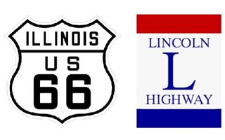
Lincoln Highway and US 66 meet in Plainfield. A. Whittall
The Lincoln Highway predated this legislation; it was authorized in 1912, and it linked New York with San Francisco. But it had not been conceived within the coherent network laid down by the 1921 Act.
As a curious fact: Route 66 meets Lincoln Highway in Plainfield, Illinois and in Joliet, IL.
The Federal Highway Act of 1921 set up a multi-year plan of federal funding for the program. It began a federal-state partnership that has endured to this day. Congress passed this Act to create a National highway system funded by the Federal government. It was to be an interstate network linking the country.
Before this Act, the country had about 2.5 million miles of roads, of which 10.5% were surfaced, but only 1.29% were paved (with bricks, concrete, or bituminous materials).
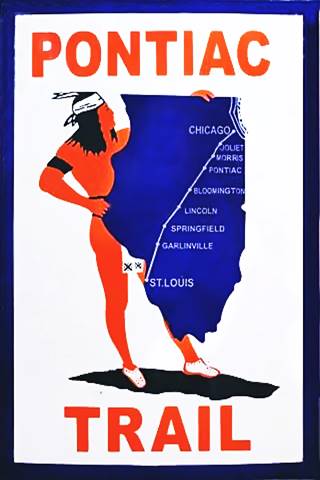
The Pontiac Trail symbol shield
State Highway 4 and the Pontiac Trail, forerunners of US66 in Illinois
An example of the improvements these laws brought is the Pontiac Trailbuilt in 1915 as the main road linking Chicago, IL, with St. Louis, MO. It even had its own shield sign (see image).
Illinois issued a bond in 1918 to build decent surfaced roads, and the Pontiac Trail became a state highway: SBI 4 or State Bond Issue highway number 4.
Federal funds were also provided, and the road was paved along its whole length by 1923.
As the automobile became more popular, the masses took to the roads, and what was once an adventure for the wealthy (and the brave) became commonplace. Americans could now roam across America, free and unchallenged.
But a choherent national highway network was needed; and this led to the creation of Route 66.
>> Learn about the Brick paved sections of Route 66
Route 66 is Born
But as Route 60!
Cyrus Avery

Cyrus Avery, "Father of Route 66". Source
In 1924, the AASHO requested that the Federal government and the states designate the highways of the national network.
The 1925 Federal-Aid Highway Act extended the funding of the 1921 act and formally created the national highway system.
Acting on this legislation, the AASHO agreed to call these highways "U.S. Highway", defined the shield and decided which specific trails and state highways were to be included in the new National Highway System.
These had to be numbered rationally. A Committee (the Joint Board) was organized for the task, and Cyrus Avery (1871–1963), an entrepreneur from Tulsa, Oklahoma, who had promoted the interstate corridors, was a member.
The number system was the following:
- North to South roads would be assigned odd numbers, starting with 1 on the East coast and ending with 91 in the West (now it ends with U.S. 101)
- East to West roads would be even, starting with 2 (along the Canadian border) and ending with 90 in the south.
- The main transcontinental routes would be multiples of 10.
The Associated Highways Association of America (AASHO) adopted the Committee's proposal, which incorporated 75,000 miles of pre-existing roads into the National Highway system.
Cyrus Avery and Route 66
John Thomas Woodruff (1868-1949) from Springfield MO was a businessman and promoter of the Ozarks highways; he presided over the Inter-Ozarks Highway Association and lobbied to get Missouri state highway 14 (later US 66) and highway 5 (now US 65) laid through Springfield, MO.
In 1926, Woodruff and Cyrus Avery founded the U.S. Highway 66 Association. Woodruff was its president.
They successfully lobbied for a highway from Chicago to Los Angeles through Springfield, Avery's hometown of Tulsa, and the mining area in the tri-state area near Joplin, MO, Galena, KS, and Miami, OK.
Route 66 was almost named Route 60
This highway was to link Chicago with Los Angeles, and even though it was not a transcontinental road, Avery wanted it to be numbered as if it were: U.S. 60 (a multiple of 10).
Its course from Tulsa, OK to the West Coast roughly followed the 35th parallel route scouted by Lieutenant Edward Fitzgerald Beale back in 1857.
But the U.S. 60 name was disputed by a highway following the historical National Roosevelt Midland Trail. The feds proposed Route 62 as an alternative, but Woodruff and Avery came up with number "66" and on April 30th, 1926 they sent a telegram from Springfield MO to Washington DC: "Regarding Chicago Los Angeles road if California Arizona New Mexico and Illinois accept sixty six instead of sixty we are inclined to agree to this change. We prefer sixty six to sixty two." and it was approved and Avery became known as "The Father of Route 66".
Route 66 was born that day. It would link the small farming towns of the Midwest with the main markets at each end of the highway. A commercial highway, for trade and also for local farmers and small stores along the Main Streets of those towns.
What became of US 60?
U.S. 60 began in Newport News, Virginia, crossed West Virginia, Kentucky, and the Mississippi at Cairo, ending at its crossing with U.S. 66 in Missouri near Springfield. Only later would it continue across Oklahoma and Texas, crossing Route 66 again, in Amarillo, and reaching Los Angeles, running along what is now the alignment of I-10. Its current western terminus is in Quartzsite, AZ.
This change may seem trivial, but it altered the numbering of Route 66's spurs (U.S. highways that forked off from the highway), two of them have survived their parent and are still alive today: U.S. 166 and U.S. 266.
The Six Spurs of Route 66
> > Read more about The six spurs of Route 66
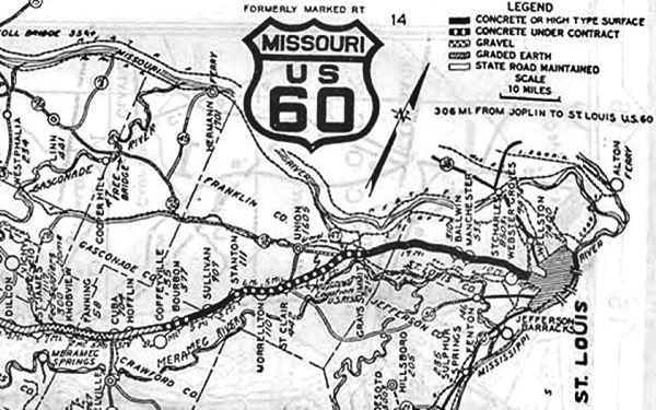
Below is a 1926 Map of Route 66 from St. James to St. Louis, Missouri. Notice that this first map calls it "US 60", instead of US 66 (click map to see original pdf)
The First Years of U.S. Highway 66
When it was designated in 1926, U.S. Highway 66 simply replaced the county roads and state highways -often in poor condition- along its alignment by the simple method of renumbering an existing road and providing Federal support to improve those that previously belonged to state networks.
Only 800 miles of the roadway were paved; the rest was gravel, dirt (like the infamous muddy stretch known as the Jericho Gap in Texas) or paved with bricks or wooden planks.
Real paving efforts began in 1926 but would not be completed until 1938.
Like the pioneer days, when they outfitted at St. Louis for all points in the West and Southwest, so today people traveling by auto find themselves coming to St. Louis over the various U.S. roads, and when arriving in St. Louis, by consulting their map, find U.S. 66 is the most direct road to the Pacific coast and likewise to all points in the great Southwest.
I challenge anyone to show a road of equal length that traverses more scenery, more agricultural wealth, and more mineral wealth than does U.S. 66. Avery Cyrus
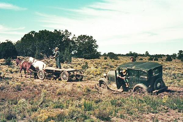
The soapy mud would become impervious and stick to anything, bogging down cars with its weight.
Ribbon Road or Sidewalk Road
An example of this hodgepodge system is a segment that became part of Route 66 in Oklahoma. It has survived until today: it is a stretch of 3.5 miles-long between Afton and Miami, Oklahoma.
It was built as a state highway between 1919 and 1924, and is an example of early paved-road building techniques.
It is an extremely narrow highway only nine-feet wide and is known as the "Sidewalk Road" or the Ribbon Road.
The "Ribbon Road" in Miami, OK.

by Jimmy Emerson, DVM
Impact of Route 66
It did have a significant impact on the small communities and large towns that were lined up along it: traffic brought business and customers to local merchants, garages, and filling stations. It also allowed goods to flow from local farmers and factories to the rest of the nation.
Its southerly course made it a popular alternative to other east-to-west corridors: it had a more temperate climate than those located further north, and it crossed the flat prairies, avoiding high passes in the Rocky Mountains; that meant that it was open during the winter.
America's Main Street
Avery and John Woodruff's National U.S. 66 Association had two goals: promote the road and have it paved.
Avery named it "The Main Street of America" at the Association's first Conference. It was a hit, evoking local stores lined up along the road, which in fact was the Main Street in each of the towns it crossed.
It was promoted as the shortest route between the Great Lakes and the Pacific Coast, and also as a scenic route: the Ozark region, the Texas Panhandle, and the Grand Canyon in Arizona.
1930s: Route 66 Improves
As traffic increased, the road and the travel infrastructure improved. Places to stay overnight, gasoline stations, garages, and workshops, diners and restaurants sprang up along the highway.
A growing trucking industry found its diagonal course appealing. It linked dozens of small farming communities, and trucks distributed their produce. Truck traffic grew from 1,500 vehicles per day to 7,500 between 1931 and 1941 along the Chicago to St. Louis segment.
Route 66 is Paved
The National highway network aimed at being modern and safe: the sharp 90° of the original alignment (which mostly followed surveyor's section lines) were eliminated, lanes were widened, and road surface was improved.
Until 1933, this was done by the individual states. By 1929, the Illinois and Kansas segments of the highway were fully paved, while Missouri had paved 66% of the road. Further West, quality decreased from 25% in Oklahoma to virtually zero paving from there to the West Coast.
>> Read about The dangers of Route 66: Dead man's curves, overpasses, narrow roadbed, traffic!
The Great Depression & US66
But in 1929, Wall Street's Stock Exchange collapsed, and the period of bonanza ended. The Great Depression began; hard times had arrived.
A severe economic depression started with the collapse of the Stock Market in October 1929 and spread around the world.
GDP plummeted globally (around 15%), and the world's economy and international trade declined abruptly, falling by 50%. Unemployment grew by up to 33%.
The onset of World War II, with increased government spending and high demand for labor, ended the depression and unemployment.
The Dust Bowl

Heavy black clouds of dust rising over the Texas Panhandle, March 1936
Arthur Rothstein
A severe drought in the 1930s, coupled with wind erosion due to poor farming techniques, led to vast dust storms in the prairies of the U.S. and Canada.
Clouds of dust darkened the sky (black blizzards) and deposited dust as far east as New York. Over 100 million acres (400,000 km2 were affected by erosion and drought.
Tens of thousands of families had to abandon their farms as they defaulted on their mortgages. They had to seek fortune elsewhere.
An estimated 210,000 people took to the road and migrated to California seeking jobs. But the Depression had struck the nation, and most of them drove back; only 8% of them remained in the Golden State.
Their comings and goings helped business along Route 66, and many mom-and-pop businesses survived the Depression years, catering to them.
Route 66 propped the local economy in Kansas, Oklahoma, Texas, and New Mexico through the New Deal programs implemented by President Franklyn D. Roosevelt.
The New Deal Civilian Conservation Corps and Works Project Administration programs included road maintenance and improvement as their main features, and thousands of unemployed men worked on road gangs between 1933 and 1938.
It is thanks to these programs that Route 66 became the first highway in America to be completely paved by 1938. The last segment of dirt was the infamous Jericho Gap in Texas. The celebration was held in Amarillo, Texas.
Grapes of Wrath and the Mother Road
[Migrants] come into 66 from the tributary side roads, from the wagon tracks and the rutted country roads. 66 is the mother road, the road of flight. John Steinbeck, Grapes of Wrath
It was John Steinbeck, who would later win the Nobel Prize in Literature, who coined the name "Mother Road". As a Californian, he experienced the plight of those fleeing from the terrible effects of the Dust Bowl, only to find no hope in California. In 1939, he penned his novel, Grapes of Wrath, recording the suffering of a migrant family who lost their farm during the Depression.
> > Learn More about the Grapes of Wrath
Thanks to the book and the 1940 movie, Route 66 has remained seared in the American memory. Route 66 was, for those escaping famine and unemployment, the "Road to Opportunity".
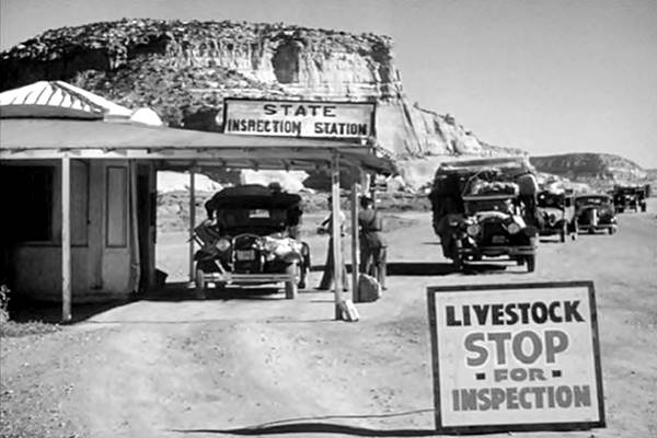
A scene from the movie "Grapes of Wrath" shot at Lupton, Arizona.
Looking east from the Border Control Station close to the Painted Cliffs in Lupton. Route 66 as it was in 1940 when "The Grapes of Wrath" was filmed
The Western Terminus of Route 66
The western terminus of Route 66 (1926-36)
Between 1926 and 1936, Route 66 had its Western Terminus in downtown Los Angeles (on what is now Ezat Delijani Square on Broadway and 7th St.; nowadays there is a marker there).
In 1936 the highway was extended to Santa Monica and a new endpoint was designated for U.S. 66
1936 - 1964 Terminus in Santa Monica
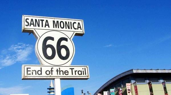
Most believe that Route 66 ends at Santa Monica Pier, and that is a very good example of excellent marketing by a Route 66 souvenir shop located on the pier. The true end point is actually located a few blocks away, at the intersection of Lincoln and Olympic Blvds.
Then there is a third endpoint: the bronze marker on Santa Monica and Ocean Ave., a memorial to Will Rogers, which states that it is "The End of the Trail".
Confusing, isn't it? Read the full story about Where does Route 66 Start and End?
The "End of the Trail" sign on Santa Monica Pier
Politics and U.S. 66
For 9 years (1926 - 1937), U.S. 66 followed a northern course through Santa Fe in New Mexico until a spiteful politician changed its course.
Governor A. T. Hannett lost his 1927 bid for re-election and was annoyed with the local politicians and businessmen in the capital city of Santa Fe. He decided to punish them and reroute US 66 to bypass that city (Read about Route 66's Santa Fe Loop)
Below is a 1927 Map of Route 66 showing Santa Rosa, Santa Fe, and Albuquerque, the "loop through Santa Fe", and the shorter NM state Highway 6, which would become Route 66 after 1937:
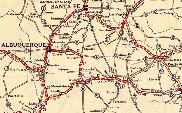
Running against the clock before his tenure ended, he had a 69 mi. stretch of state highway (State Hwy. 6) built linking Santa Rosa with Moriarty and shaving off more than 90 miles off the road.
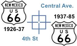
But his "revenge" would have to wait for 10 more years until the Federal roadbuilders decided to straighten the road and shorten it. When they did so in 1937 they used Hannett's alignment.
For this reason Route 66 crosses itself in downtown Albuquerque, where the old and new alignments meet.
Route 66 during World War II
The Great Depression ended with the sudden increase of Government investment and spending caused by the US involvement in World War II (1942 - 1945).
Below is a 1930s photo looking north along Route 66 towards the Canadian River in Oklahoma, where a bridge can be seen in the distance. Click on the image to see the same view nowadays.
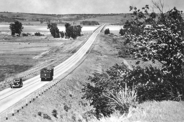
The Western part of the country was chosen by the War Department for the location of new military training bases; the dry weather was ideal for the purpose and the area was geographically isolated.
Due to its alignment, Route 66 became a major player during the war effort and was upgraded even before the war began.
In Los Angeles, California, the federal government funded the first freeway of the West, and the second in the country, the Arroyo Seco Parkway. It was built between 1938 and 1940 as part of the National Strategic Roads System. It carried Route 66 into Los Angeles.
>> Learn more about the Historic Arroyo Seco Parkway
Fort Leonard Wood in Missouri, Fort Wingate Ordnance Depot in New Mexico, the Ammo factory in Elwood IL, Navajo Ordnance Depot in Arizona and Edwards Air Force Base in California, were built near Route 66. There were also Prisoner of War camps, like the POW Camp in McLean, Texas.
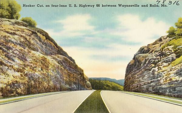
Larger trucks were built during the war, and U.S. 66 was the main link between Eastern and Western U.S.; long convoys transported military supplies and troops along the highway. The heavy traffic required a better highway, and Route 66 began to be upgraded to a four-lane divided expressway in many parts, like in Hooker Cut (1941-43) MO, or in Plainfield and Elwood, Illinois
New industries were developed by the Federal Government in California, and they drew thousands of workers from across the nation; many of them traveled by car along Route 66 to reach their new jobs.
The 4-lane U.S. Highway 66 in Hooker, Missouri built in the 1940s
Golden Age: Post War Years on Route 66
The years of rationing ended with the War in August 1945, and America kept on the move. Millions of soldiers, airmen, and sailors came back home, but remembering their training days in the balmy Southwest, relocated there, abandoning the cold winters of the Northeast. And many drove to their new homes along US 66.
Sunbelt states grew between 40% and 74%. This massive shift in demographics was a boon for business along Route 66. Motels, tourist courts, and service stations flourished in the post war prosperity.
Get Your Kicks on Route 66
One of those roaming former soldiers was ex-Marine captain Robert William Troup Jr., "Bobby" Troup, who penned the hit "Route Sixty-six" while riding along Route 66 between Chicago and L.A. in 1946
It became an instant hit and has been recorded until this day by many singers, from Aerosmith to the Rolling Stones.
>> Lear all about "Get your Kicks", the song, its lyrics, meaning and more.
1950s and 60s Travel and Fun on the highway
The years of thrift and suffering were gone, people celebrated life and traveled, they took to the roads in their cars to explore America, its nature and culture.
The National Parks in the West like the Grand Canyon and Petrified Forest drew growing crowds of visitors.
Families drove to see the wild open lands of the "Far West"! Cowboys and real Indians. It was exotic, and it was America.

"The Teepees". Petrified Forest National Park, AZ. Austin Whittall

Blue Whale, Catoosa OK.
Wacky '66 sights
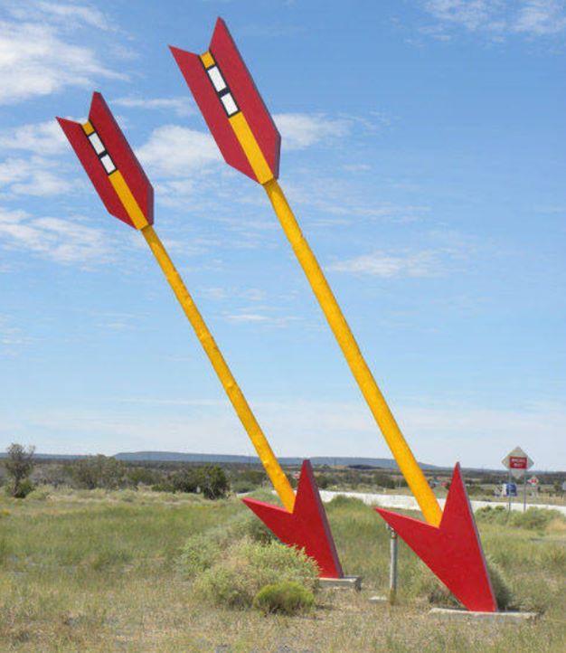
Then there were the unusual, weird, and quirky landmarks along the highway and the mystique of the Native American cultures that drew motorists from all over the country. These were trips of sightseeing and also a journey of adventure and discovery along the Main Street of America, an attraction in itself.
Decline and demise: Route 66 Slowly Fading Away

The Dry Creek - Whiting Brothers Gas Station in Newberry Springs
But the changing global context would also lead to Route 66's demise.
The war had exposed the weaknesses of America's highways: heavy loads deteriorated the paving, makeshift repairs during the war did little to help; the roads and bridges were narrow, outdated, and unsafe. Something had to be done, and quickly.
>> Learn more about the Dangers of Route 66 during its heyday
Post-war years brought increased traffic, which reduced the carrying capacity of roads. At the same time, the Nation became aware of the importance of a good highway network for national security during the Cold War.
President Eisenhower had a very high opinion of the Autobahns he had seen in Germany during WWII and was convinced that America needed a similar system of divided highways that could offer safety and speed.
His Federal Aid Highway Act of 1956 was passed by Congress, and the Interstate system was funded and soon began to cover the nation.
Interstate vs. Route 66
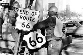
Route 66 shield being removed, Jan 1977, Chicago. Source
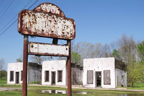
Interstate highways were multilane, limited-access, divided highways that were built following straight alignments, bypassing small towns and killing off the small mom and pop businesses that were located in the towns. Motels closed and relocated by the freeway's exits.
Avon Court (Motel) Route 66 in Afton, Oklahoma
Over the next few years, I-15 replaced Route 66 between Los Anglees and Barstow in California, I-40 from there to Oklahoma City; I-55 from Chicago to St. Louis, and I-44 from St. Louis to Oklahoma City took care of the remaining segments of U.S. 66. This process began in 1956 and took almost thirty years to be completed, but it was implacable.
The American Association of State Highways and Transportation Officials (AASHTO) ruled on June 26, 1985, to eliminate its designation.
Williams, Arizona, was the last town to be bypassed in 1984.
Route 66 no longer existed.
This year, as Route 66 celebrates its Centennial this year, we should also remember that 2026 also commemorates 41 years since it was decertified as a U.S. Highway.
>> Read more: Route 66 hasn't existed since 1985!
>> Learn More: Why was Route 66 Decommissioned?
US 66 Gone
Many states had already taken down the "obsolete" signs: California did it back in 1964, Illinois in 1977. Others placed signs reading "Old U.S. 66". But in general the decommissioning of the highway led to its gradual deterioration. Road maintenance decreased, the Mother Road was being forgotten and falling into disrepair.
Route 66 Returns
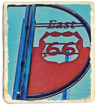
Route 66 sign in Albuquerque, New Mexico. A. Whittall
But the public would not let the Mother Road die; private organizations and government offices soon recognized the significance of U.S. 66 for the communities that it passed through.
A significance that was not only economic, but also social and historic. Route 66 had to be preserved.
Starting in 1987, when The Historic Route 66 Association of Arizona was founded, many groups were formed to preserve, protect and promote the grand old road.
Their efforts have paid off:
- Numerous landmarks and historic buildings have been nominated and listed in the National Register of Historic Places.
- Route 66 has been declared in some states as a National and + or State Scenic Byway.
- The route has been designated as "Historic" in several states and as a Scenic byway on a National and State level.
- New Signs and road marks have been emplaced along the highway to guide travelers along their road trips.
Route 66 Corridor Preservation Program
Law 101-400 enacted by Congress in 1990 recognized that U.S. 66 had "become a symbol of the American people's heritage of travel and their legacy of seeking a better life."
Within its framework, a study conducted by the National Park Service evaluated its significance and identified ways to preserve it.
The outcome was Public Law 106-45, which created the Route 66 Corridor Preservation Program, which finances and assists with upkeep designated historic resources along the Mother Road.
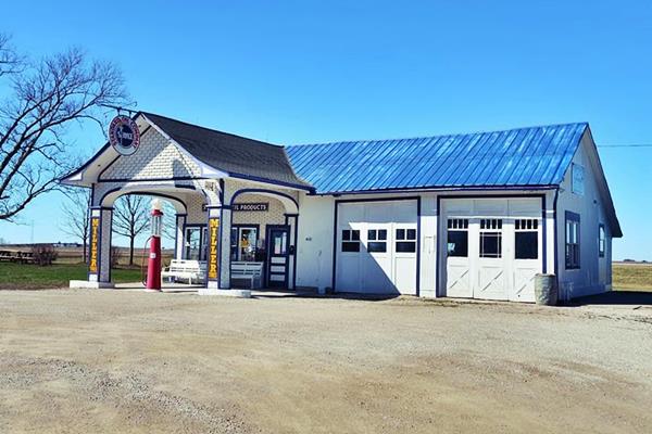
Below is a restored vintage gas station on Route 66 in Odell, Illinois:
Historic Standard Oil Gasoline Station in Odell, Illinois
A lasting legacy! Route 66 is "Alive and Kickin'"
Route 66 Centennial, 1926-2026
The Mother Road is here to stay, on its way to its 2026 Centennial. Thousands of visitors flock each year to feel its paving under their wheels and to fill their eyes and souls with the spirit of America.
>> Learn all about this celebration on our Route 66 Centennial Page
So don't worry if Route 66 worth driving?, we are convinced that it is definitely worth it! So add it to your bucket list.

Sponsored Content
>> Book your Hotels in Illinois

Credits
Banner image: Hackberry General Store, Hackberry, Arizona by Perla Eichenblat.

