
Route 66 meets the Pine Forests
Index to Flagstaff Attractions
On this page:
On our Flagstaff Page #2
Flagstaff Facts
Facts, Trivia and useful information
Elevation 6,910 ft (2.106 m). Population 77,540 (2025).
Time zone: Mountain (MST): UTC minus 7 hours. Summer (DST) no DST⁄ PDT (UTC-7).
Flagstaff is a city in northwestern Arizona, it is the county seat of Coconino County and Route 66 crosses the city.

Where to Stay. Your Hotel in Flagstaff
There are many hotels and lodging options on Route 66 in Flagstaff.
>> Book your Flagstaff
More Lodging Close to Flagstaff along Route 66
There are plenty of lodging options in the cities and towns along Route 66 east and west of Flagstaff; click on the links below to find your accommodation in these towns, listed from east to west:
Eastwards
In Arizona Along Route 66
Westwards
You are so close to Las Vegas and the Grand Canyon!


>> There is a RV campground in Flagstaff
Map of Route 66 through Flagstaff
Visit our Winona to Williams Alignment page for a detailed description of Route 66 through Flagstaff. Below is the color coded interactive map:
>> Custom map of Route 66 in Flagstaff

Map of US66 alignments in Flagstaff
click to enlarge
You can also check out the map in downtown Flagstaff by clicking on the image, or by visiting our Route 66 Map of Arizona, with the all the alignments of US66 and all the towns along it in the state of Arizona.
Flagstaff, Arizona, its Sights and Attractions
Things to Do and Places to See
- In Flagstaff (see below)
- Tours & Itineraries (on Page 2)
- Parks and outdoors (on Page 2)
Route 66 Icons
Historic context, the classic Route 66
In 1946 Jack DeVere Rittenhouse rode along US 66 and wrote his memorable book "A Guide Book to Highway 66" detailing his journey.
After leaving Winona Rittenhouse writes that the road climbs steeply towards Flagstaff. He mentions Camp Elden "Another camping spot, with a garage and cafe" east of Flagstaff, and then the town itself, listing its hotels: Monte Vista, Weatherford, Bank, Commercial; many courts (motels), including: Arrowhead Lodge, El Pueblo, Flagstaff Motor Village, Rock Plaza, Vandevier Lodge, Nickerson's, Mac's Motor Inn, Cactus Gardens, Dixon and Sunset.
Rittenhouse mentioned that "US 66 goes down the main street of Flagstaff, and soon you are on the road among tall pines again. At 101 mi... is Camp Kit Carson"
Flagstaff: "get your kicks on Route 66"
The classic song "Get your Kicks on Route Sixty-six" was written in 1946 by Bobby Troup during his trip from Chicago to Los Angeles. Flagstaff is one of the three Arizona tonws mentioned in the song (the others are Kingman and Winona).
Read More: Get your Kicks on Route 66, full details on the song and its context.
Now you go through Saint Looey
Joplin, Missouri,
And Oklahoma City is mighty pretty.
You see Amarillo, Gallup, New Mexico,
Flagstaff, Arizona.
Don't forget Winona,
Kingman, Barstow, San Bernardino.
Sights in Flagstaff
This 1.4 mile walk (Map with Directions). Will take you through the historic downtown district of Flagstaff.
Historic Downtown District
Downtown, Flagstaff, AZ.
Listed in the National Register of Historic Places
This landmark comprises the old downtown district of Flagstaff and the south side of the Santa Fe railway station; it has many memorable late 1800s buildings and iconic Route 66 landmarks.
Two Spot Logging Train

The Logging Train. Click for St. View
Listed in the National Register of Historic Places
Route 66 and N. Agassiz St. Start your tour by the steam engine, tender and log wagon built in 1910 by the Baldwin Locomotive Co. Retired in 1966 of the Arizona Lumber & Timber Company
Across the street, facing you is The former Greyhound bus terminal, now Arizona Music (St. view).
Head west, passing by the Historic 1890 Railroad Depot and then follow the 1926-34 alignment of Route 66 by turning left, crossing the tracks at San Francisco St. and heading south to Phoenix Avenue.
Downtowner, Sierra Vista and DuBeau Motels

On the SW corner o Phoenix and San Francisco is the former Downtowner Motel. It was originally the home of K.J. Nackard, who owned a store nearby.
He converted his home into a motel on Route 66 in the mid 1920s, in 1933 added a "bunkhouse" and in 1935 the wing that enclosed the court.
Don't miss the faded red neon sign on top of the former office (19 S. San Fransisco) or the Marker on its wall.
Follow Route 66's 1920s and early 1930s alignment west down Phoenix Ave. to Beaver St. on the corner is the Motel Sierra Vista with its restored neon sign.
Head west one block to the SW corner of Phoenix and Beaver. Here is the former 1929 DuBeau Motel Inn with its neon sign on the top of a tower.

Neon sign Sierra Vista Motel. Click for St. View

Dubeau Motel Neon Sign. Click for St. View
Cross Beaver St. and continue down Phoenix Ave. to Mike’s Pike. Here Route 66 crossed the Rio de Flag and took a left towards the SW along Mike's Pike.
B&M Camp
Follow it to Cottage Ave., and on the SE corner (100 Mike's Pike) are the remnants of a home built in 1896 which in 1926 became a store with several cabins; the B&M Auto Camp, (see a street view of it).
The town's 1929 business directory mentions Jules (Ubaldina) Bonal as "mgr. B&M Grocery, B&M Camp, B&M Auto wrecking, at 102 Milton Road, and Bowen, V. (Ella) as barber at Longley's Barber shop, B&M camp, Milton Road. The 1945 Flagstaff Phone Directory [1] mentions the B & M Auto Court at 102 Mikes Pike, B & M Auto Wrecking Co. 207 W Cottage Av., and B & M Coffee Shop in downtown at 7 N San Francisco.
The images show a then-and-now sequence, red arrow shows the oldest church in Flagstaff (Our Lady of Guadalupe, built in 1888) and the blue one, the former Gas station. It has changed since 2008 (2018 view).

B&M in a vintage photo. Click to enlarge

Former B&M in 2008. Click for St. View
Double Circle Garage
Ahead, past the church, to your left is the 1926 garage, still operating as a repair shop. The building retains its same square shaped facade.

The Double Circle Garage in 1938
Albert E. Tate Collection North Arizona Univ.

The Double Circle Garage today.
Click image for Street View
Go straight to the corner where Mike's Pike meets Butler Ave. and Milton Rd. at "Five Points". Here is where Route 66 took a left along Milton Rd. to the SW. It is also where the 1934 alignment was built northwards to the Underpass.
Underpass and the 1934 alignment
The old alignment became congested at the railroad crossing on San Francsico St., so with Federal aid, the underpass was built just west of the railway station and opened on Dec. 24, 1934.
Coming from the south, the road passed under the tracks and then took a sharp turn to the right, eastbound.
Canyon Inn
The Spur Motel stood at "Five Points", but was razed. Just south of it, on Route 66 is the Canyon Inn with a great neon sign it used to be the Starlite Motel (1970s photo of its neon sign). Behind it is a mural with a cow painting, it was the National Guard Armory, now it is Natural Grocers.

Former Imperial 400 Motel
At 223 S. Milton Rd. Facing the Cow Mural; the classic motel is still standing and operating, now as the Highland County Inn. Imperial Motel chain was founded in 1959 and had an eye-catching "butterfly roof".
>> You can Book a Room in This Motel.
Composite image: 1960s and current view of this Classic motel. Click image for Street view

Imperial '400' Motels and Route 66
Learn all about these Space Age motels along U.S. 66.
> > Read more: Visit our Imperial "400" Motels on Route 66 webpage.
L Motel
North along Milton Rd. is the "L Motel", now a Rodeway Inn. In the 60s it was owned by Mr. and Mrs. Alvin A. Arnsten. The rooms are the same, but the central office is gone. See the images below:

The "L" Motel in a 1960s vintage postcard. Source

"L" Motel today. Click for Street View
Granny's Closet
218 S Milton Rd. As you go north towards the underpass, to your right is the now closed Granny's Closet (see a street view of it).

A vintage 1960s postcard of the Lumberjack. ebay.com
It was the original location of the Muffler Man in the image. It was built in the early 1960s and was named "Paul Bunyan Café" and later renamed as "The Lumberjack Café. Next to its main entrance stood a 20-foot tall fiberglass lumberjack (6.1 m).
The postcard depicted in the image proclaimed: "The Lumberjack Cafe Welcomes you to FLAGSTAFF 7000 feet above the sea - 7000 sights to see Delicious Pancakes, Waffles and Breakfast "Heavenly Fried Chicken" Famous $1. 66 Dinners LOOK FOR THE BIG 20 FOOT LUMBERJACK PLEASE DRIVE CAREFULLY - COME SEE US SOON".
The phrase "LOOK FOR THE BIG 20 FOOT LUMBERJACK..." is a clear indication of its advertising effect, a landmark to attract new customers.
Present Location
However you won't see it on the sidewalk of Milton Road. The giant has moved to the Skydome at the Northern Arizona University (NAU); now it is the mascot of the NAU lumberjacks.
Nowadays, as you can see in the image below, his jacket and cap sport different colors (See a street view).

>> More information, visit our Muffler Men on Route 66 page.
There is a small lumberjack just north of the old Cafe (street view). Cross the underpass and reach the north side of the railroad. To your left is another motel.
Vandevier Motel

1950s Postcard Vandevier Motel in a 1960s, Source
402 W. Santa Fe Ave. NW corner, just north of the underpass. Though the two story gabled house is gone the long one story building along Santa Fe Ave. is still there. See its Street View, and compare it with the postcard showing how it looked in the 1950s in the vintage postcard (click it for larger view).
Walk back towards the station on the right side of the road just by the underpass is an old concrete bridge wall of Route 66 where it crossed the Rio de Flag (Street view). The City Hall complex replaced many classic Route 66 places, but on the NE corner of Humphrey's St. is what used to be the Lane Motel.:
Lane Motel
122 Historic Rte 66, Flagstaff. The Lane Motel opened in 1948 on Route 66 and Humphrey's Street, in downtown Flagstaff. It was run by Haydee Lane and Joe Sharber. The part that faced Route 66 had a Texaco service station.
It is still standing, though the service station has closed. Nowadays it is the Roadway Inn. Below is a 1940s motel and a current Street View.
The postcard's back says: "Lane Motel U.S. 66 and 89 Flagstaff, Arizona Phone: 750 A nicely furnished, 17 unit, steam-heated motel with private baths. Innerspring mattresses. Walking distance to theatres, cafes and shopping district. Complete 24-hour "one-stop" Texaco Service while you sleep. A Lane, Sharber and Sharber Enterprise.".

The two story building on the rear part of the property is intact, but the front, facing Old Route 66 has changed considerably.


Route 66 shield by Visitor Center in Flagstaff AZ. This photo is courtesy of TripAdvisor.
Flagstaff Visitor Center & Route 66 shield
One East Route 66. Head west, cross to the south side of Route 66 to visit the Visitor Center (the 1926 Historic Railway depot) and enjoy the Route 66 Shield and have your Route 66 Passport stamped. Then walk one block east to cross to the north side of Route 66 and head north along N. San Francisco St.
Monte Vista Hotel
NE corner of Aspen and N. San Francisco St. Pictured at the top of this page. Built in 1926 with its great sign above its roof. Walk east along Aspen to the next street to the historic "Weatherford Hotel".
Weatherford Hotel

Weatherford Hotel now. Click for St. View
Listed in the National Register of Historic Places
23 N. Leroux St., Flagstaff, AZ. Classic Centennial Hotel established in 1897 by John W. Weatherford. It was one of the first stone buildings in town (to avoid fire risk). It was originally housed a general store. The brick three-story hotel opened on New Year's Day 1900. A fire damaged its balcony and it was removed with the cupola in 1929. It has been restored since the 1970s. The Orpheum theater next to it is still standing.
The Weatherford Hotel is still recognizeable; a spire has been added to the top of the building on the corner and also a roofed wrap-around balcony on the third floor to recover the original early 1900s appearance.
The postcard below, from the 1940s gives a very good description of the local attractions: "FLAGSTAFF, largest city in beautiful Northern Arizona, near snow-capped Flagstaff Peaks, towering 12,655 ft. Highest point in Ariz. Winter skiing, summer picnicking. FLAGSTAFF is the "Capitol" of the Canyon Country. Crossroads U. S. Highway 66 and 89. Ideal stopover to see: GRAND CANYON OF ARIZ., the World's Mightiest Spectacle Colorful OAK CREEK CANYON, unparalleled beauty SUNSET NATIONAL MONUMENT, 9th Century preserved crater WALNUT CANYON NATIONAL MONUMENT, Pueblo Cliff Dwellings The WEATHERFORD, one of Flagstaff's finer hotels, downtown close to everything. Newly furnished and decorated. You will find friendliness and hospitality here. Truly your home away from home."

Historic Bank and Hotel
Turn left towards Route 66. On the NW corner of Leroux and Route 66 is the historic Bank Building (see a street view of it)
it was built in 1887 and completed by McMillan in 1888. It housed a bank, a hotel and after 1898, the Stagecoach to the Grand Canyon as well as the McMillan Opera House.
Your walking tour ends here.
Tours & Itineraries Near Flagstaff
- East side of Flagstaff along US66
- West side of Flagstaff along US66 (on Page 2)
- To the NW of the city (on Page 2)
Tour the East Side of Flagstaff
Head east along Route 66 from the Visitor Center. The image shows a view along Route 66, eastwards, with the Chamber of Commerce building on the right side, the station further away and Route 66 with its traffic in the middle. The postcard below was printed in the 1950s, and shows us how the scenery has changed over the last 60 years.
A view eastwards along Route 66 in downtown Flagstaff 1950s (postcard)

The same spot today, looking east along Route 66

Mobil Station & Ford Service
NW corner of N Verde St. and US 66. The building with the Mobil - Ford signs is still there, in the 1950 Yellow Pages it figures as "Flagstaff Motor Inn - Mobil 216 E. Santa Fe", the Texaco facing it was Parker Howard's Texaco.


Next to the Texaco was Dobrinski's Richfield Station (306 E Rte. 66) still there, though a small Café has been built over the pumps island (St. View). Ahead was Walker Al Chevron Station (640 E Rte. 66) mentioned in the 1951 Yellow Pages (St. View)
.Whispering Winds Motor Hotel
922 E Route 66. The 1960s postcard mentions its "T.V. & Telephones, Swimming Pool, Steam Heat, Cooled by Refrigeration". Open, offering weekly rates.

1960s postcard Whispering Winds
Source

Whispering Winds Motel today.
Click image for Street View
Ahead is a former Der Wienerschnitzel (1302 E Rte. 66), a chain that opened in 1961 and was the "world's largest hot dog chain". They had a large A-frame building with a drive-thru in the middle. This one built before 1970, is now a "Dog Haus" (St. View).
Amber Sky Motel
1418 E Route 66. Ran by the Davies in the 1950s, the motel building has lost its western wing and part of its northern one (red arrow). Now it is L-shaped instead of U-shaped. It has expanded east and was renamed the "Relax Inn Motel".

Amber Sky, 1950s postcard. Source

Amber Sky today. Click for Street View
New Skyline Motel
1526 E. Route 66. This 1950s motel promted its "Spacious rooms, newly furinshed... courteously managed by Mr. and Mrs. Lester Smith". No longer New Skyline, it is still operating, now as the Travelers Inn Motel.

New Skyline in a 1950s postcard. Source

New Skyline today. Click for Street View
Kings House
1560 E Rte. 66. Below is a composite with 1960s and current view of this classic motel (Now it is an Econo Lodge). It was a "New Concept in Motels... large, luxurious rooms". Earlier it had been Porter House.
> > You can Book a Room the Econo Lodge

Western Hills Motel
1580 E Route 66. The motel was built by Harold Melville in 1951 who sold it to Charles Greening in 1954. He ran a Coffe Shop in the office building.
The Motel's Neon Sign is the oldest one in Flagstaff. The motel is still operating, and is exactly the same (from sign to buildings) as it was in the 1950s. See the postcard below, from the 50s and the current street view further down: unchanged.
Postcard from the 1950s, Western Hills Motel


Former Hyatt Chalet Motel
1990 E Rte 66, St. View. Still open as a motel, it is the Americas Best Value Inn & Suites Flagstaff. This design dates back to 1960 when Hyatt planned to build some 200 similar motels by 1966. They became the Hyatt Lodges, a new division within the company. Notice the steep gabled roof and compare it to the other extant motels of this chain, also on Route 66 in Albuquerque NM, Needles, and Pasadena CA. Below is a 1965 advert in the Western Gateways magazine

Next to it is a former Denny's Diner with a classic "Boomerang Roof", a desing by Armet & Davis from the early 1960s, street view. Next to it was the now razed "Wonderland Motel".
Arrowhead Lodge
2010 Historic Route 66. This old lodge with log and stone cabins distributed in a L-layout around the main building is now an apartment complex with the same original buildings. In the 1950s and 60s it was known as the Twilite Motel and the Gaslite Motel Below a then-and-now sequence.

Arrowhead Lodge 1940s postcard. Source

Arrowhead Lodge today. Click for Street View
Time Travel 1950-2020
Check out these two images showing the same view Looking east in the 1950s (a postcard) and a street view with the same view now. The highway now is much wider, but you can still make out the Arrowhead and Route 66 Motels, and in the distance, the yellow sign of the Whiting Bros. gas station.
Motel 66
2100 Historic Rte 66. See the Motel 66 in the postcard below printed in the 1950s. The motel has retained its appearance with the same stone walls, gabled roof and sign (although now it is painted differently).

The postcard above, from the 1950s, says on the back of the card: "The Motel with a smile' 2100 E. Santa Fe Ave. Flagstaff, Arizona 86001 11⁄2 miles east of Downtown Flagstaff. 15 units, some kitchenettes, hot water heat, refrigeration, televisions and garages. Phone 774-6403".

Next door is the icebox style former Denver's Thunderbird Mobil Service station.
More Route 66 sights & attractions
Flagstaff Whiting Bros. Gas Station

WB service station now. Flagstaff. Click for St. View
2136 E Rte 66. This icebox shaped former gas station and then is the Whiting Bros. station, now a car rental. The original building is still standing, and is currently the offices of Enterprise Rent-A-Car. The two concrete pump islands and the canopy held up by four steel posts are still there.
The steel superstructure that supported the sign on top of the canopy is clearly visible. This was their #91 station.
Whiting Bros. Motel Flagstaff
2140 W Historic Rte 66. Next to the WB station. The postcard states "36 units - See Beautiful Northern Arizona". the building is very similar to the one in North Holbrook, with the gabled roofs above the two-floor building. Even the office canopy has the saw-tooth design. The motel is still open, and is now a Rodeway Inn.
A 1960s postcard of the Flagstaff Whiting Bros. Motel

> > You can Book a Room the Rodeway Inn

Next to it was Stan's American Service station, now Chris' Double D Tire. Across the street on the corner was the Flag Texaco Service Station encircled by the still open Flagstaff Motel (2204 E Route 66), see this St. view of the former Texaco and the motel.
Read more about Whiting Bros. & Route 66
Americana Inn
2650 E Route 66. A sixties motel with the space age geometric design of that time. See those rhombus atop the building which now were reduced to triangles. It is still operating. See it then and now below.

Americana early 1960s postcard. Source

Americana today. Click for Street View
Shell Station
2740 E Route 66. This was H-L Huffler Shell and Firestone Service in the mid 1960s. The canopy on the western tip of the site was a design exclusive to Shell, butterfly wing. Street View.
Miz Zips and Texaco Station (Former Camp Elden)
2818 E Route 66 is the Pine Crest Motel and the former Red Bluff Frontier gas station.
2924 E Route 66. A classic American diner and Route 66 roadhouse with its "Let's Eat" neon sign. Still going strong since 1952. Below is a then-and-now sequence showing the diner (blue arrow), unchanged. The Texaco now repurposed (red arrow) and one of the posts of its sign (black arrow).
It was owned by Norma and Bob Leonard, who also owned the Texaco and the now closed "L &L" motel next to it. The motel was replaced by the "Mountain View" which was later torn down. Now the Travelodge stands on the site (2918 E Route 66). A Chevron station stood between the motel and the Texaco in the 1950s.
Site of Camp Elden in the 1930 what is now Miz Zips was Camp Elden Café, a Campground. The Texaco sold Red Bluff gasoline, and there was a store where the modern Travelodge Motel now stands. See this 1930s photo.
Composite with 1960s and current view of this classic motel. Click image for Street view

On the next corner is Stahl's Richfield Station.
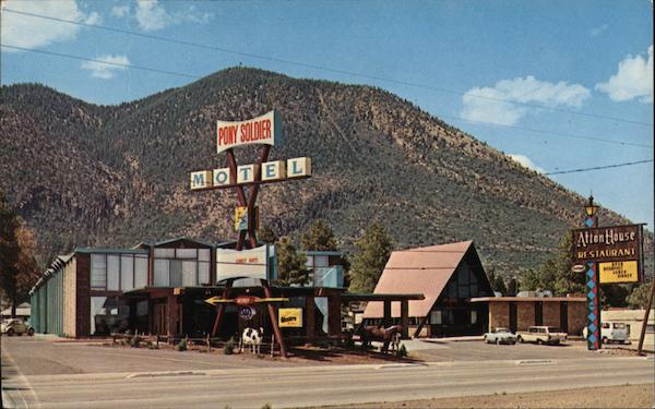
Pony Soldier Motel
3030 E Rte. 66. This is another classic that is still operating as a motel it has a 1960s Googie style saw-tooth shaped roof atop the two floor building and a large A-frame on its eastern side.

Pony Soldier 1960s postcard. Source

Pony Soldier Motel today. Click for Street View
Former Geronimo Motel
3100 E. Rte 66. Now it is still open, as the "Mountain View Inn". Below we can see a 1970s postcard of the Geronimo Motel, with a "modernistic" entrance canopy held up by three columns, a picturesque sign and a shaded parking area. Behind the building, a steep gabled roof can be seen (part of the motel next door).

Nowadays the trees are gone, and so is the canopy, but the building has retained its original exterior appearance, and the gabled roof is still there, behind the motel.

El Pueblo Motor Court
3120 Historic Rte 66, Flagstaff. The postcard below, from the 1950s, show the El Pueblo Motor Court (or motel). The building is still there, but in a more built-up setup.
El Pueblo Motor Court

Nowadays it is the "El Pueblo Motor Inn", it is still surrounded by pines and the motel area has the same Spanish tiles on its roofed porches. The office building has replaced the old roof with asphalt roofing, but the building is the same.

Phillips 66 Gull Wing station
3122 E Rte. 66. In very good shape, this early 1960s "New Look" gull wing station is still open, now as Mike's Bikes and Montevista Marine. See the original inclined glass plate windows in the office and the slanting V-shaped canopy.

Ahead, at 3200 E Route 66 is Gilliland's Enco service station (St. View) followed by (3220 E Route 66) Mack's Flying A Service Station (St. view).
Crown Motel and Restaurant
3300 E Rte 66. Te 1960s modern design of the Crown Motel has survived. Now it is a Howard Johnson, and the neon sign on the restaurant is still there. Below is a composite showing it in the early 1960s and nowadays.

Dean Eldrege Museum
Museum Club
Listed in the National Register of Historic Places
3404 E. Route 66. Street View. Dean Eldredge purchased the land in 1931 for a "museum to house many strange and curious relics" on U.S. 66. he built a two-story log house 72 x 43 feet. It's entrance has an inverted fork of a ponderosa pine 11.5 by 9.5 feet. It was refurbished in 1990 and now it is a dance club and roadhouse.
It is followed (3363 E Route 66) by a 1960s Bowling Alley, Starlite Lanes which is open.
Ruins of Elden Pueblo
E. Route 66, Flagstaff, AZ. Just 6.5 mi. east of Flagstaff along US 66 - 89, see this map with directions.
Listed in the National Register of Historic Places
This site preserves the ruins of a Native American village at the foot of Mount Elden. The Sinagua people lived here in stone homes from 1070 to 2175 A.D. About 250 people lived in this village.
The site was discovered in 1926 and has yielded shell jewelry from California, macaw remains from Mexico, evidence that the pueblo was part of a trading system. Park on the left side of the road, and walk 350 feet to the northwest, to the ruins.
This ends your Tour in Eastern Flagstaff.
Turn back towards the downtown or head east to visit the Wupatki National Monument and the
Sunset Crater National Monument or head even further to see the Monument Valley Navajo Park. We describe them all on Page 2.
> > See the previous segment Winslow to Winona
> > See this segment Winona to Williams
More Flagstaff attractions on the Next Page
We describe the rest of Flagstaff's attractions on Flagstaff Page 2
Some sponsored content
Lake Havasu City

Lake Havasu City, the lake and London Bridge. Source
The resort town of Lake Havasu City on Lake Havasu has beaches along the lake's scenic shoreline, an active nightlife and the original London bridge (you can take a Tour to visit it)
The adjacent state park is open 24 hs, and there is an entrance fee. It is located on a reservoir on the Colorado River. You can hike and enjoy the riverside.
Visit the scenic shoreline with beautiful beaches, nature trails, boat ramps, and many convenient campsites.
>> Book your Hotel in Lake Havasu City
Learn more about the outdoor sites in the Havasu State Park official website.
>> Book your Hotel in Flagstaff AZ
Credits
Banner image: Hackberry General Store, Hackberry, Arizona by Perla Eichenblat
Priest S., et al., (2001) The San Francisco Volcanic Field, Arizona USGS.
The James R. Powell Route 66 Collection at the Lake County Discovery Museum images are shown under Fair Use.
Will Croft Barnes, Arizona Place Names, University of Arizona Press, 1988.
Historic Route 66 in Arizona All-American Road, National Scenic Byway, www.fhwa.dot.gov.
Jack DeVere Rittenhouse, (1946). A Guide Book to Highway 66.