The location of US 66?
Table of Contents
Index to this page:
- Exact location of Route 66
- Description of Where Route 66 is located
- Why does Route 66 run as it does?
- Legacy of Route 66
Exact location of Route 66
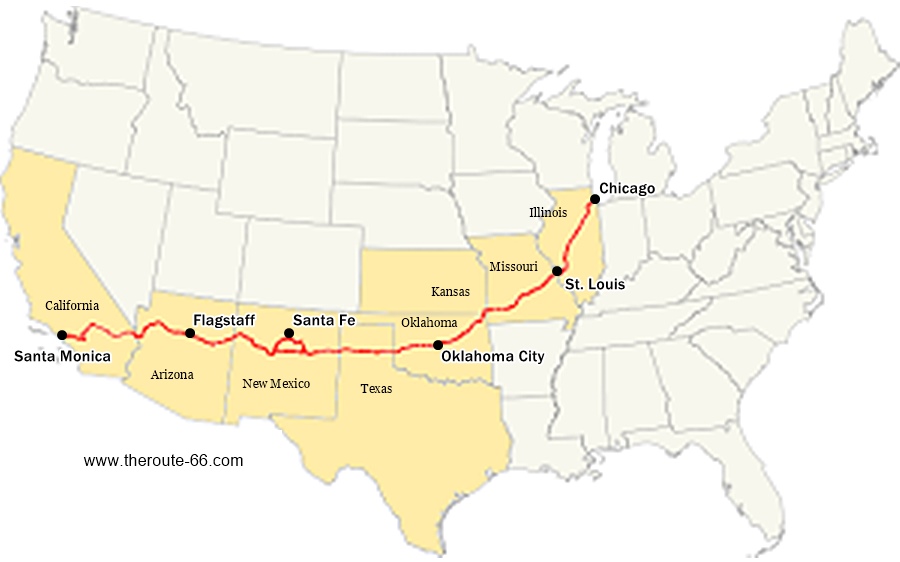
The following map shows where Route 66 is, marking its alignment, including the "Santa Fe Loop" through Santa Fe in New Mexico.
Map showing where Route 66 alignment is located

Description of Where Route 66 is located
Route 66 runs with a northeast to southwest course across the US, from Chicago, Illinois to Santa Monica, California.
The state-by-state alignment is the following sections.
Ilinois
It crosses the state of Illinois from NE to SE, going from Chicago on the western coast of Lake Michigan, and running through Joliet, Normal, and the state capital city: Springfield. Here the original 1926-30 alignment runs further west and the later, 1930-1974 alignment further east, both meet at Staunton. Further south at Hamel the alignments open up again, as over the years it ran along different courses towards St. Louis in Missouri. But, all roads converged on St. Louis Missouri after crossing the Mississippi River.
Total mileage: 289 miles.
Missouri
It runs for 313 miles and keeps its NE-SW course across Missouri, running from St. Louis through Villa Ridge, Stanton, Cuba, Rolla, across the Ozarks, into Springfield MO, and then wets to Carthage and Joplin in the "tristate" region where Kansas, Oklahoma, Missouri meet.
In 1974, the eastern terminus of Route 66 was moved from Chicago to Scotland, a community located close to Joplin. It remained there until 1985 when the highway was delisted.
Kansas
From Joplin, the highway enters Kansas. This is the shortest stretch of US 66 (13 miles long) crossing the southeastern corner of Kansas starting in Galena, crossing Riverton and then south through Baxter Springs into Oklahoma.
Oklahoma
The 376 miles of US66 run from the NE "tristate" corner to the Texas border in central-western Oklahoma.
It runs south through Miami and Afton then SW through Vinita, Claremore and Tulsa.
Southwest through Chandler and Edmond, into the state capital: Oklahoma City. West again through El Reno and Clinton and then to the SW through Sayre, Erick and Texola on the state line.
Texas
Route 66 crosses Texas east to west (189 mi), from OK to New Mexico, through Shamrock, Amarillo, Vega, Adrian and Glenrio. Cutting across the "Panhandle region."
New Mexico
In New Mexico it has an East to West course (392 miles long) through Tucumcari and Santa Rosa, here the original alingment from 1926 to 1937, known as the Santa Fe Loop takes a wide curve north through Pecos, Santa Fe (the state capital city), Santo Domingo and Algodones it crosses the later alignment at Albuquerque, swooping in a small circle to the south and then west (through Peralta and Suwanee).
The main course (post 1937 alignment) runs from Santa Rosa through Moriarty, Albuquerque, Suwanee, Grants, Continental Divide and Gallup, reaching Arizona at Lupton.
It crosses the southern Rocky Mountains in its final segment in NM.
Arizona
In Arizona it has a general East to West course from Lupton through Winslow, Flagstaff, Williams, and here an arch north to Peach Springs, heading SW again through Kingman and Oatman to Topock crossing the Black Mountains (1926-52). The realignment in 1953 bypassed the mountains running through Yucca. It ends in Topock on the Colorado River. Total: 388 miles.
California
It crosses the Colorado River into California and heads North from Topock to Needles and Goffs then southwest through Essex -road cut due to some bridges washed away by rain some years ago- to Amboy. West again to Ludlow and Barstow and south through Oro Grande, Victorville, across the Cajon Pass between the San Gabriel and San Bernardino mountains, into San Bernardino.
East to west through Los Angeles eastern suburbs into Pasadena then South into Los Angeles and west to the Pacific Ocean and its western terminus in Santa Monica.
Total mileage 318 mi.
Total miles from Chicago to Santa Monica: 2,278
State-by-State color coded alignment Maps
Each state has its own interactive map showing where Route 66 runs. And also several interactive maps with the different alignments through each state.

Little Deep Fork Creek Bridge. Bristow OK. Credits
- Illinois Route 66 Map
- Missouri Route 66 Map
- Kansas Route 66 Map
- Oklahoma Route 66 Map
- Texas Route 66 Map
- New Mexico Route 66 Map
- Arizona Route 66 Map
- California Route 66 Map
>> Detailed Description of Route 66
The description in each state show the original 1926 alignment and all of the later realignments. With plenty of pictures and maps Some parts are now the frontage road of the Interstate highways or buried under the freeway, some sections of the early roadway have vanished.
Why does Route 66 run as it does?
The purpose of the creators of US 66 was to link the heartland of America with the Pacific coast and with the large rail hub of Chicago, to move produce from the Great Plains.
Chicago was a major railroad and Great Lakes shipping hub and at that time it was the coutry's second most populous city (after New York).
Los Angeles had surpassed San Francisco to become California's most populous city in 1920. And shortly after US66 was created it became the 5th most populous city in America.
Cyrus Avery (read more about Avery in our History of Route 66 page)who was the mastermind behind US 66 and the Federal Highway System promoted its virtues:
- The shortest and most direct route from the Great Lakes to the Pacific Coast
- No high mountain passes across the Rockies, passes that could get snowed in during winter
- Key link across Illinois prairies and Missouri's Ozarks
- Outlet for the lead and zinc mines in the tristate region (OK, KS, MO)
- Link to the oilfields of Oklahoma and northern Texas
They also lobbied for it to be paved and straighter than the Ozark Trail and National Old Trails "roads" along which many state highways had been aligned in the 1920s, ant these were initially used as the Route 66 alignment when it was created in 1926.
Postcard with map of Route 66: Chicago to Los Angeles
Its alignment was also included in postcards, which also mentioned the main sights, cities and included images of them:

Legacy of Route 66
Route 66 has been part of the American way of life since it was created in 1926 until its demise in 1985.
Spanning the country from the Great Lakes to the sunny shores of the Pacific Ocean, it was the highway that led people all across the nation to new lives, jobs,
a journey that was one of survival during the Dust Bowl of the 1930s, of hope and progress during the post World War II years, and of fun, joy and vacations during the 1950s and 60s.
Soon the highway will celebrate its 100th birthday! Read all about the planned celebrations at our Route 66 Centennial (1926-2026) webpage.

Sponsored Content

>> Book your Hotel in Arizona

Credits and Further Reading
Banner image: Hackberry General Store, Hackberry, AZ by Perla Eichenblat

