Route 66 in Beverly Hills CA
Index to this page
About Beverly Hills California
Facts, Trivia and useful information
Elevation: 259 ft (79 m). Population 29,904 (2025).
Time zone: Pacific (MST): UTC minus 8 hours. Summer (DST) PDT (UTC-7).
Beverly Hills, also known as "Garden Spot of the World" and "Bev Hills" is famous for being the home to many rich people and Hollywood celebrities. Its coveted 90210 zip code is a symbol of success for those who live here.
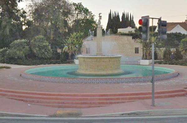
Electric Fountain in Beverly Hills, on Route 66
The history of Beverly Hills
This area has been inhabited for over 10,000 years. Spanish explorers reached the region in 1542 and encountere, the Cahuilla, Tongva and Chumash natives.
Los Angeles was settled in 1781, and ranches were established close to the town. Sunset Strip was the trail built to link L.A. with the coastal area and along it, in what is now Beverly Hills, Quinteros de Valdéz established their 4,500 acre (1820 ha) ranch in 1828, the "Rancho Rodeo de las Aguas".
At that time, Mexico had already been six years independent from Spain, and California was part of its territory. However, it lost it to the U.S. after the 1846 War. The former province became a U.S. state in 1850.
Benjamin Wilson and Henry Hancock purchased the ranch in 1854 and subdivided it, selling the land to new settlers who arrived from the east. Andrew Denker and Henry Hammel bought part of the land and grew crops of lima beans on it. They planned a town which would be named Morocco, but never platted it.
After oil was discovered in L.A., the Amalgamated Oil Co. was formed in 1900 to find oil in what would become Beverly Hills, but the wells did not produce enough oil so they changed their company's name to "Rodeo Land and Water Co.", and in 1907, developed the land into a town: "Beverly Hills".
The Name: Beverly Hills
One of the town's developers had been a resident of Beverly Massachusetts. Which originated the first part of the name. This town on the eastern coast had been settled in 1626 and was named after the town in Yorkshire England, founded in 700 AD by Saint John of Beverly, bishop of York.
The hills to the north inspired the town's second part, so it became "Beverly Hills"
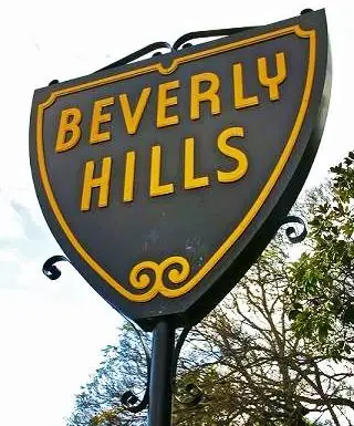
Beverly Hills Plaque on Sunset Blvd. Source
Though sales were slow at first, the Beverly Hills Hotel opened in 1912. Hotel guests liked the area and acquired land there. The city began to grow and incorporated in 1914.
When Hollywood stars Douglas Fairbanks and Mary Pickford bought land in Beverly Hills in 1919, other movie stars (Rudolph Valentino and Will rogers) followed suite and built their mansions in the new town.
The 1939 "Guide to the Golden State" written by the WPA described Beverly Hills like this:
"... the home of many luminaries of the cinema world. Standing like a small island almost surrounded by the irregular boundaries of Los Angeles, it is an independent city... Many of the earlier motion picture stars built homes here because the then undeveloped rolling foothills offered ample space for large estates near Hollywood studios and ocean beaches. Today it has become almost traditional for the principal screen stars to be represented in the community by large homes, partly because of their publicity value; and Beverly Hills residential architecture has achieved a new note of splendor. Most of the mansions are in the foothills; in the level lowland area south of Sunset Blvd. are smaller bungalows, bungalow courts, apartment houses, and hotels. Many privately owned concerns conduct tours through the city, and up-to-date guide books listing the names and the constantly changing addresses of the well-known residents are available"...
"Many actors and extras still live in Hollywood, but most of the stars prefer Beverly Hills, Bel Air, Brentwood, and ranches in the San Fernando Valley."
Where to Lodge in Beverly Hills
Lodging in Beverly Hills
> > Book your hotel in Beverly Hills
More Lodging near Beverly Hills along Route 66
Below you will find a list some of the towns along U.S. Hwy 66 east and west of Beverly Hills; click on any of the links to find your hotel in these towns.
>> Check out the RV campground near Beverly Hills, in Pomona
Weather in Beverly Hills
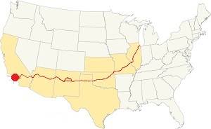
Location of Beverly Hills on Route 66
Beverly Hills has its own micro-climate: which is warm and hot, averaging. Summer is hot and dry, with hardly any wind and winter is not terribly cool due to the moderating effect of the sea.
However January nights can be quite cool. Spring is warm and Fall is short swinging from hot to cool. Beverly Hills has some 296 sunny days each year.
The average high during summer (Jul) is 85°F (29.4°C); the summer average low is 62°F (17°C). The winter (Jan) average high is 67°F (19.5 °C) with an average low of 46°F (8°C). Snow is very rare and has only fallen five times since 1882.
Rainfall averages 18 in. (460 mm) yearly concentraded between December and April. During the rest of the year less than 0.5 in. falls monthly.
Tornado risk
Beverly Hills is located barely 7 miles from the Pacific Ocean and well beyond the Rocky Mountains (which are the western limit for tornados) so there is no risk of tornados in the city.
Map of Route 66 through Beverly Hills California
>> Custom map of Route 66 in Beverly Hills
Read the detailed description of the last leg of Route 66 from Pasadena to Santa Monica
Also check out Beverly Hills on our Route 66 Map of California.
Route 66 Alignment into Beverly Hills
Route 66 was created 1926 but it originally ended in downtown Los Angeles. In 1936 it was extended along Santa Monica Blvd. (Then State Highway 2) all the way to Santa Monica. It passed right through Beverly Hills and remaind so until it was decommissioned in 1964 as a U.S. Highway in this area.
With maps and full information on the Mother Road.
- Pasadena to Santa Monica (Beverly Hill's)
- Barstow to Pasadena (Previous)

Tourist sights in Beverly Hills
What to Do, Places to See
Beverly Hills Trivia
- Celebrities who live or lived here include: Desi Arnaz & Lucille Ball, Justin Bieber, Richard Chamberlain, Ellen DeGeneres, Mia Farrow, Demi Moore, Lionel Richie, Charlie Sheen, James Stewart.
- The town has appeared in many movies and TV shows, here are two of them: The Beverly Hillbillies (1962 – 1971) and Beverly Hills, 90210 (1990 to 2000).
- Will Rogers, a.k.a. "Mr. Route 66" was the city's honorary mayor (he had been born in Claremore, Oklahoma on Route 66).
Beverly Hill attractions
Beverly Hills is well known for being the city of the famous and wealthy who shop on Rodeo Drive.
Below we describe a short (just over 6 miles long) tour around Beverly Hills (Map with directions).
The Eastern Tip of Beverly Hills
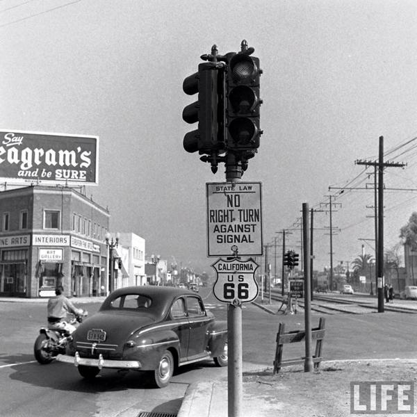
At the crossroads where N Doheny Dr, Melrose Ave. and Santa Monica Blvd. meet, when you leave West Hollywood for Beverly Hills, two classic photographs were taken showing what this spot looked like during Route 66's golden days. Below are the pictures and the current views at those spots.
Doheny Dr. and Santa Monica Blvd.
The first picture taken in 1948 depicts a two story brick building on the NE corner of both avenues, next to which stands the famous Troubador Club. At that time, Santa Monica Blvd. ran as a double two-lane avenue on both sides of the tracks of the Pacific Electric Railway tramline system that ran down the middle of the road. Notice the Route 66 shield.
The color photo shows the same spot nowadays.
Doheny and Santa Monica Blvd. 1948
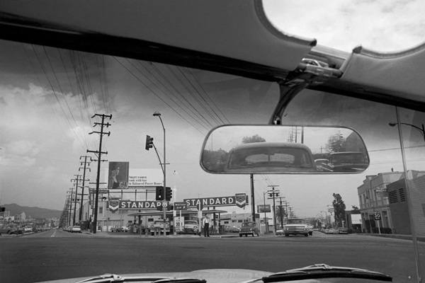
Melrose Ave and Santa Monica Blvd.
The second picture was taken sometime between the fall of 1963 and summer of 1964. The author, actor Dennis Lee Hopper (1935-2010) was driving eastwards alonr Route 66 with a friend and he saw the intersection. He later stated that "I liked the billboard, I liked the idea that the Route 66 sign was there" (it is on the traffic light). He took the picture just as the light changed to green. This is a view at the same spot nowadays. The Standard station is long-gone.
Melrose and Santa Monica Blvd. 1964
City Hall
Beverly Hills Historical building
Drive westwards to 455 North Rexford Drive, Beverly Hills. This building was designed by William J. Gage and Harry G. Koerner. It was built in Spanish Revival Style and it opened in 1932. It was designated as part of the city's list of historical preservations in 2013.
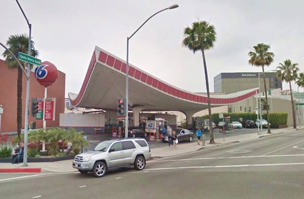
Union 76 Gas Station
Crescent Drive and South Santa Monica Blvd. This is classic example of Googie Architecture. Architect Gin Wong designed it as part of Los Angeles International Airport, but the design was used here, and the service station was built in 1965.
Its curved triangular canopy supported by two columns is like a spacecraft lifting off. The canopy's contour is decorated with squares.
Googie architeture was born in California in the 1950s, and was very popular in the 1960s. Its bold geometric shapes proclaimed the coming of both Space and Atomic Ages. Boomerang shaped roofs, glassed structures and angled buildings were very popular and many cafes, gas stations and fast food outlets sported them.
head west and take a left along Rodeo Drive
Rodeo Drive
Rodeo Drive south of Santa Monica Blvd. This Drive is to Beverly Hills what Fifth Ave. is to New York: an avenue with expensive high end chic brands.
Though the avenue runs for 2 miles, the commercial section is a short three blocks between Santa Monica Blvd. on the north and Wilshire Boulevard on the south.
The rich and famous shop here at the best boutiques: Bucci, Dior, Chanel, Armani, Valentino, Ralph Lauren, YSL, Cartier and Tiffany.
North of Santa Monica Boulevard, are the homes of many Hollywood Stars.
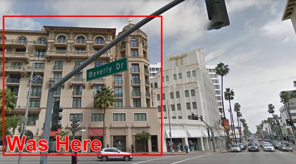
Site of the Beverly Theatre
206 N. Beverly Dr., Beverly Hills
Demolished in 2005, the theatre opened in 1925. It was designed to resemble a Chinese Temple with a domed roof. It could seat 1,270 spectators. It closed in 1977. (Further Reading).
Site of the former Beverly Theatre in Beverly Hills
Sterling Plaza
9429 Wilshire Boulevard. To the right of the former theatre (see image above), is the historic Art Deco styled Sterling Plaza. It was built in 1929 and was the California National Bank building in Beverly Hills. It is a seven story structure completed just before the Crash of 1929. It was acquired by Donald Sterliing in the 1990s and renamed after him.
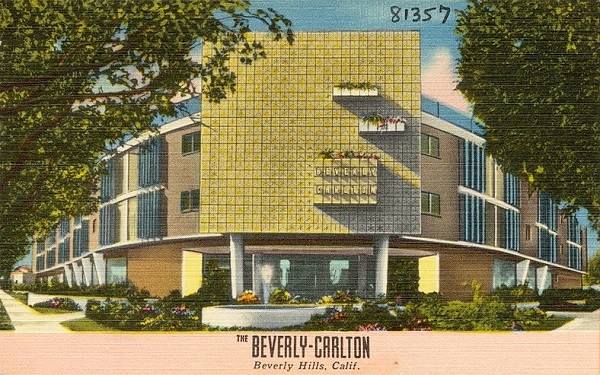
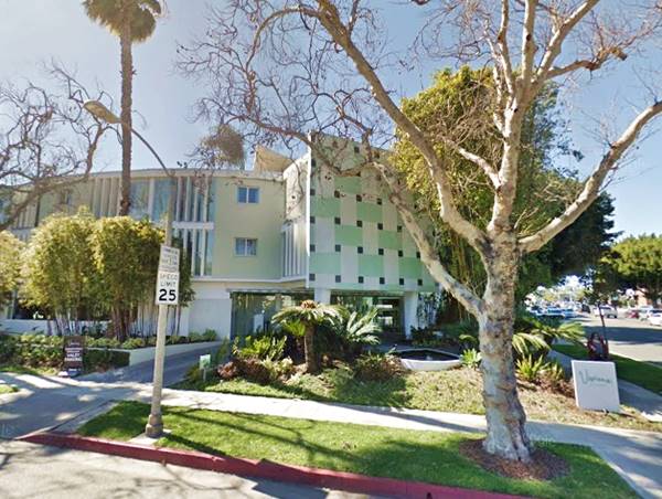
Avalon Hotel Beverly Hills former Carlton
9400 W Olympic Blvd,. Beverly Hills. The former Beverly Hills Carlton was built in 1949. It was Marilyn Monroe's home for 3 years. Refurbished recently it still maintains its 50's facade but is now a 4-star boutique hotel.
Antique ca. 1950s postcard view of the Cartlon Hotel
Former Beverly Carlton now: Avalon Hotel Beverly Hills
Now head north to visit a classic:
The Beverly Hills Hotel and Bungalows
Historic Landmark
9641 Sunset Boulevard. The hotel opened in 1912, two years before Beverly Hills incorporated. Designed by Elmer Grey, it was built in Mediterranean Revival Style.
During the 1940s its restaurant, the "Polo Lounge" opened, and in 1948 it was painted pink. The Crescent Wing was built in 1949.
It was named the first historic landmark in Beverly Hills in 2012.
Electric Fountain
Now head back to Route 66 and go west along Santa Monica Boulevard to visit the Electric Fountain, on the corner of Santa Monica Blvd. and Wilshire Blvd.
When Santa Monica Park was renamed Beverly Gardens in 1930, the fountain which had been planned inthe late 1920s was erected at the busy intersection.
Designed by artist Robert Merrell Gage (1892 - 1981) and built by Ralph Carliin Flewelling.
The small sculpture at the top is a Tongva native in prayer, the fountain includes terracotta tiles in Art Deco style and a frieze depicting the history of California.
It gets its name from the changing lights that illuminate it (see it above).
Continue your Road Trip
Head west to continue your Route 66 road trip in neighboring South Pasadena.

Sponsored Content
>> Book your Hotel in Santa Monica

Credits
Banner image: Hackberry General Store, Hackberry, Arizona by Perla Eichenblat
A Guide to the Golden State; Federal Writers' Project of the Works Progress Administration, Hastings House, New York, 1939.
Jack DeVere Rittenhouse, (1946). A Guide Book to Highway 66.


