Route 66 in West Hollywood CA
Index to this page
About West Hollywood California
Facts, Trivia and useful information
Elevation: 282 ft (86 m). Population 33,916 (2025).
Time zone: Pacific (MST): UTC minus 8 hours. Summer (DST) PDT (UTC-7).
West Hollywood, also known as "The Creative City" is a relatively new city (it incorporated in 1984), located Route 66 in Los Angeles County in southern California.
The history of West Hollywood
People have lived here for more than ten thousand years. When the Europeans reached the coastal area by ship, in 1542, the Cahuilla, Tongva, and Chumash natives lived in the area.
The Spanish settled here trekking north from their viceroyalty of New Spain in Mexico, setting up California and founding the town of Los Angeles in 1781. It was at that time that a trail was built to link the new town with the Pacific Ocean, the road ran through ranches like "La Brea" and "Plummer". This trail would later become "Sunset Strip."
Mexico retained control of the territory when it won its independence from Spain in 1821, but lost it to the U.S. after the 1846 - 1848 Mexican American war. California and other Southwestern states like AZ, NM, UT, CO and NV became a part of the US. California became a state of the Union in 1850.
As Los Angeles grew founding its wealth on oil, the film making industry moved to the Hollywood foothills, from its original hub in New York to take advantage of California's sunny weather, ideal for filming in the early 1900s.
West Hollywood began as a small railroad town named "Sherman" located west of the magnificent green garden that was Hollywood, home to Los Angeles' business men in the early 1900s.
Sherman was a small farming area in western Cahuenga Valley. It was located in the flat frost-free fields at the foothills of the Hollywood Hills. It had been founded by W.H. White. The village was named after Moses Sherman who built the Los Angeles Pacific Railroad, later absorbed by the Pacific Electric Railway tramline system.
Sherman was the site of the railroad's yard and shops, and was the home of many working-class people who, in the early 1900s, as the City of Los Angeles expanded to reach the Ocean, decided not to incorporate into the City of Los Angeles.
Sherman was a free minded place where Prohibition was loosely enforced despite being part of Los Angeles County. The town adopted its current name, "West Hollywood," in 1925.
Casinos and clubs sprung up here along Sunset Strip, as gambling was illegal in Los Angeles City.
The 1939 "Guide to the Golden State" written by the WPA described what is now West Hollywod as follows:
Farther west [of Hollywood] on Sunset Boulevard, toward Beverly Hills, is a section popularly known as "the Strip." Here are the Trocadero and other movie colony night spots, high-priced antique shops, salons, gift shops, restaurants hung with Venetian blinds, couturiers and modistes, theatrical agencies; most of them white-painted modified Georgian-Colonial buildings with green shutters. WPA, 1939
The Sunset Strip remained a night-life hot spot gradually becoming less seedy. Later, during the 1960s it became the home to the music and recording industry.
Prompted by L.A.'s plans to deregulate rent controls, the locals -mostly renters- voted to incoporate as "City of West Hollywood" in 1984.
The Name, West Hollywood
This was the name used by a real estate development company in the 1920s that cashed in to the better known "Hollywood" (of movie fame), adding "West" to the name, due to Sherman's location.
There are several myths about the name Hollywood, some involving the holly bush.
Route 66 in West Hollywood
Route 66 was established 1926 but ended in downtown Los Angeles until it was extended along Santa Monica Blvd. in 1936, to reach Santa Monica, passing through what is now West Hollywood.
Accommodation in West Hollywood
Lodging in West Hollywood, find a room, in a hotel or motel in town.
> > Book your hotel in Hollywood
More Lodging near West Hollywood along Route 66
Below you will find a list some of the towns along U.S. Hwy 66 east and west of West Hollywood; click on any of the links to find your hotel in these towns.
Weather in West Hollywood
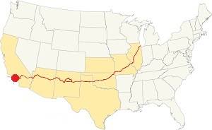
Location of West Hollywood on Route 66
West Hollywood's climate is Subtropical & semi-arid. With hot dry summers and cool wet winters moderated by the closeness to the sea which reduces the swings in the day to night temperature.
January nights can be quite cool. Summers are hot and spring is warm while Fall is short, both cool and hot.
West Hollywood has some 295 sunny days each year.
The average high during summer (Jul) is 80°F (27°C); the summer average low is 62°F (17°C). The winter (Jan) average high is 67°F (19°C) with an average low of 46°F (8°C) snow may fall on the San Gabriel mountains but snow is very uncommon in the city.
Rainfall averages 13 in. (333 mm) yearly, mostly between December and April. During the rest of the year less than 0.5 in. falls each month.
Tornado risk
West Hollywood is located barely 9 miles from the Pacific Ocean and well beyond the Rocky Mountains (which are the western limit for tornados) so there is no risk of tornados in the city.
Map of Route 66 through West Hollywood California
>> Custom map of Route 66 in West Hollywood
Read the detailed description of the last leg of Route 66 from Pasadena to Santa Monica
Also check out West Hollywood on our Route 66 Map of California.
Route 66 Alignment across West Hollywood
Route 66 was created 1926 but it originally ended in downtown Los Angeles. In 1936 it was extended along Santa Monica Blvd. (Then State Highway 2) all the way to Santa Monica. It passed right through West Hollywoodand remaind so until it was decommissioned in 1964 as a U.S. Highway in this area.
With maps and full information on the Mother Road.
- Pasadena to Santa Monica (This one)
- Barstow to Pasadena (Previous)

West Hollywood: Local landmarks and attractions
Home to the Sunset Strip
West Hollywood and its Route 66 attractions
West Hollywood is best known for Sunset Strip with its Night Clubs, Luxury Hotels (which include
Historic Art Deco Sunset Tower) and Googie architecture like that at Mel's Drive-In.
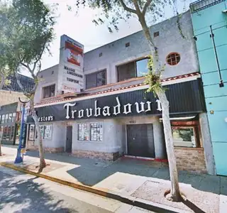
Santa Monica Boulevard a.k.a Route 66 has The West Hollywood Halloween Carnival (the largest in the U.S.), and icons such as Westlake Recording Studios, the Troubador Club, Holloway Motel and
Barney's Beanery. Don't miss the La Brea Tar Pits
Sunset Strip
The Strip, is the name given to Sunset Boulevard in West Hollywood. It is only 1.5 miles long stretch of road (2.4 km) and runs from Havenhurst Dr. in the east to Sierra Drive in the west, where Beverly Hills begins.
It is well known for its shops and night life. Restaurant, nightclubs and boutiques with their multicolored signs of all sizes line the Strip.
There was a TV Series that ran from 1958 to 1964, "77 Sunset Strip", that was set on the Strip (but used a fictional address -77- which does not coincide with the street's numbers, which here are in the 7000-8000s).
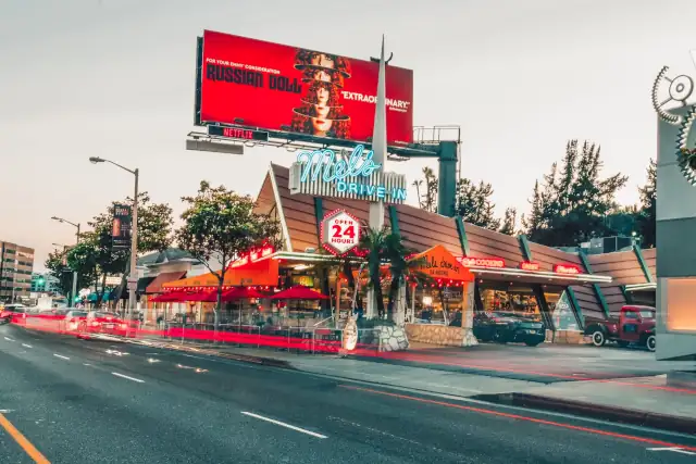
See the Night Clubs, the Luxury Hotels on the Strip and examples of Googie Architecture like Mel's shown below:
Mel's Drive-In - Googie Architecture
Sunset Plaza, 8585 Sunset Blvd, West Hollywood. This iconic American Restaurant on the Strip is a great example of the "Space Age" Googie architecture. See the image below, with its slanted angular roof and its pointed neon sign.
Googie architecture
Douglas Haskel coined the name in 1952 when he saw Googie's restaurant in West Hollywood -he was being pejorative (Googies stood at 8100 Sunset Strip, and was demolished in the 1980s.)
Googies was designed by John Lautner, a former student of Frank Lloyd for restaurateur Mort Burton in 1949.
This style, pronounced "gu:gi", it was a form of modern building design inspired in the Atomic and Space ages (think "The Jetsons"), with their geometric shapes, vast glass surfaces and symbolic motion designs (atoms, boomerangs, wing shapes, disks) with Space Age themes.
It appeared in California and was quite popular until the mid 1960s. Cafes, motels and service stations sported these modernistic designs.
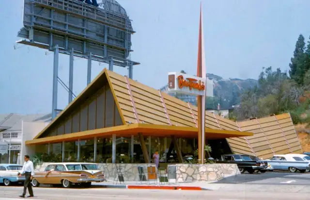
Ben Frank's pictured above opened in the early 1960s and its sloping roof, sharp angles, wide windows and modern sign are a typical googie building. It closed in 1996 and was repurposed as Mel's Drive In on Sunset Strip as you can see below.
The Night Clubs on Sunset Strip
Roxy Theatre
9009 Sunset Blvd, West Hollywood. Night Club that opened in 1973 and has had great stars play there (like Genesis with Peter Gabriel in the early 70s). Street View.
Viper Room
8852 Sunset Blvd, West Hollywood
Iconic night club with live shows. (Street View). Actor River Phoenix died here at age 23 of a drug overdose at approximately on Halloween night, 1993.
Whisky a Go Go
8901 Sunset Blvd, West Hollywood. A renowned night spot where rock bands play live (Street View).
The Luxury Hotels in West Hollywood
West Hollywood has its share of luxury hotels, some of them dating back to the 1920s, and they have lodged Rock stars and Hollywood celebrities, below are some of them.
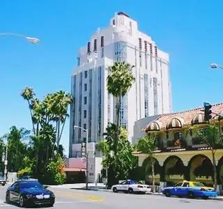
The Sunset Tower Source
Sunset Tower Hotel
Listed in the National Register of Historic Places
8358 Sunset Blvd. This Art Deco building (also known as The Argyle and St. James' Club, rises 15 stories (195 ft. - 59.5 m) on Kings Rd. and Sunset Blvd.
It was designed by Leyland Bryant in opened in 1931. It was home to many Hollywood stars such as John Wayne, Frank Sinatra, Errol Flynnm and the reclusive millionaire Howard Hughes.
It is a hotel (Sunset Tower Hotel) and a historic place since 1980.
Mondrian Hotel
8440 Sunset Boulevard. This remodelled boutique hotel was originally built in 1959 during the golden age of Hollywood.
Andaz Hotel
8401 Sunset Boulevard. This 4-star hotel belonging to Hyatt's Andaz brand was formerly the Hyatt on Sunset Blvd., was known as the "Riot House" because it was very popular among the rock and roll bands that played on the Strip. Robert Plant, Keith Richard, and Jim Morrison stayed here.
The hotel was built in 1963 when it opened as Gene Autry's Hotel Continental.
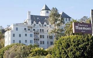
The Chateau Marmont. Source
Chateau Marmont Hotel
8221 Sunset Blvd. Another classic, designed by William Douglas Lee in 1929. Studio Boss Harry Cohn once told a young William Holden "If you must get into trouble, do it at the Chateau Marmont".
It is also known because Comic actor John Belushi died here in 1982, of a drug overdose, when he was 33 years old.
Sunset Marquis Hotel
1200 Alta Loma Rd. This 4-star hotel has a rock 'n' roll history which includes the world famous 45-person Whisky Bar and the underground recording studio of NightBird.
Sights along Santa Monica Boulevard (Route 66)
Route 66 runs just south of Sunset Strip, along Santa Monica Boulevard, and it too has some icons of bygone days that are still alive and kicking today:
Westlake Recording Studios
7265 Santa Monica Blvd. It was at Westlake Recording Studios that Michael Jackson recorded the albums "Thriller" in 1982 and "Bad" in 1987. Donna Summer and Giorgio Moroder worke here as did Quincy Jones and Van Halen. Alanis Morrissette recorded her album "Jagged Little Pill" here.
Visit their website and peek at its Street View.
The West Hollywood Halloween Carnival
The largest Halloween street party in the United States
This event takes place every year on October 31.is an event that takes place annually on October 31 from 6 to 11 PM.
It spans one mile -1.6 km- along Santa Monica Blvd. between La Cienaga Blvd. and Doheny. Partying continues in the bars (you can't consume alchol on the street). Admission is free and it is not suitable for pets or children (the crowd is nearly half a million partygoers). Don't forget your costume!
Holloway Motel
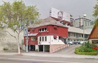
8465 Santa Monica Blvd. A Classic that has stood on U.S. 66 since the 1940s. You can see how it has changed in the images below, now it is being renovated.
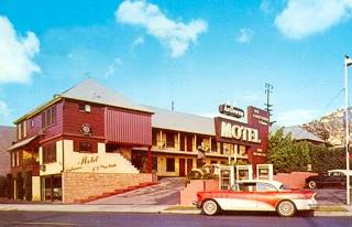
Holloway Motel postcard.
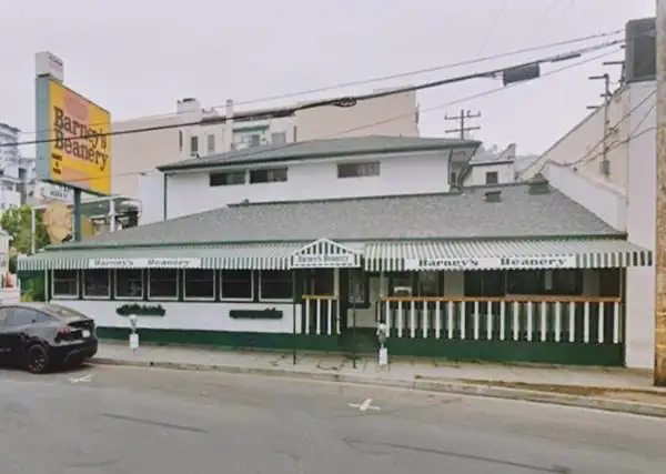
Barney's Beanery
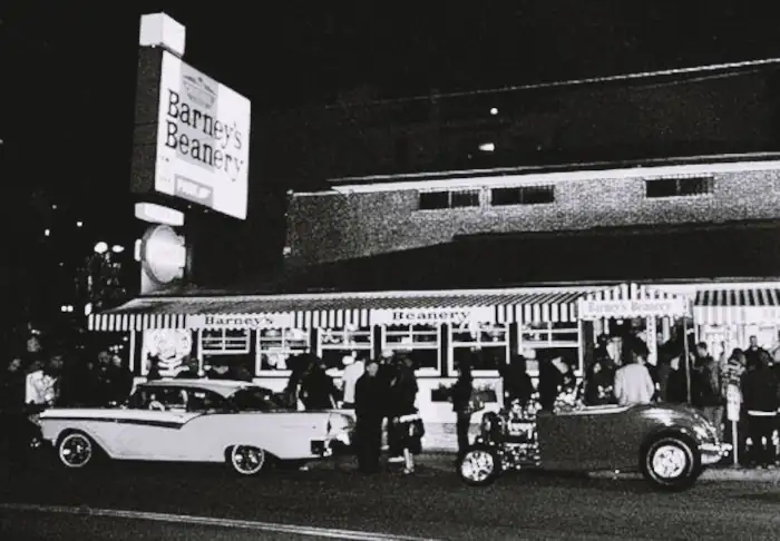
8447 Santa Monica Blvd. John "Barney" Anthony opened it in Berkeley in 1918 and moved it to warmer Hollywood in 1927 where it has stood on Route 66 since its realignment in the early 1930s. Travelers left their license plates after dinner as a gesture of their migration to California to start better lives. They mingled with motion picture writers, extras and stars like Jean Harlow, Bette Davis or Clark Gable and by rock stars like the Doors.
American food (pancakes, burgers, burritos, waffles and more) is served here.
Troubador Club
Visit a fossil site just south of Route 66 in neighboring Los Angeles.
La Brea Tar Pits
5801 Wilshire Blvd, Los Angeles, a short 4.6 mile round trip from West Hollywood (map with directions).
This is an Ice Age fossil site with a museum and recreated megafaunal animals. Open daily from 9:30AM to 5 PM.
The name "La Brea" is Spanish for "tar" or "asphalt", which surfaces here from the oil rich soil of Los Angeles. The sticky tar trapped animals such as birds, insects and small mammals and preserved their bones. Larger animals like herbivores and their predators were also caught in the sticky tar. Some couldn't escape and their remains make up the collection of the site, which has over 1 million bones belonging to animals dating back to the last Ice Age (11,000 to 50,000 years ago).
Learn more at their website: www.tarpits.org
Continue your Road Trip
Head west to continue your Route 66 road trip in neighboring Beverly Hills.

Sponsored Content
>> Book your Hotel in Santa Monica

Credits
Banner image: Hackberry General Store, Hackberry, Arizona by Perla Eichenblat
A Guide to the Golden State; Federal Writers' Project of the Works Progress Administration, Hastings House, New York, 1939.


