Route 66 in South Pasadena CA
Index to this page
About South Pasadena California
Facts, Trivia and useful information
Elevation: 659 ft (201 m). Population 25,898 (2025).
Time zone: Pacific (MST): UTC minus 8 hours. Summer (DST) PDT (UTC-7).
South Pasadena is a city located Route 66 in Los Angeles County in southern California and it is part of the Los Angeles metropolitan area.
The history of South Pasadena
This area has been inhabited for over 10,000 years. The Spaniards, when they explored the region in the 1600s encountered the "Tongva" people, and named them "Gabrieleños" or "Gabrielinos", after the San Gabriel Mountains which was named for the San Gabriel Arcangel Mission that they set up in the area in 1771. California was a province of the New Spain viceroyalty with its capital in Mexico City. Mexico became independent from Spain in 1821 and in the 1830s nationalized the Mission's land.
Part of this land, was named Rancho del Rincon de San Pascual (Saint Paschal's corner Ranch) and it covered 13,694 acres (5.540 ha). The Rancho was granted to Juan Marine in 1834; and it later passed through other owners before being claimed by Manuel Garfias, who received it as a grant in 1843 from the Mexican Governor Micheltorena.
Garfias had already built the Flores Adobe by then. In 1852 he sold part of his interest to Benjamin Wilson and ended up selling his whole property to Wilson in 1858.
By then Mexico had been defeated by the US in the 1846-48 war and lost California (and NM, AZ, CO, NV and UT). California became a U.S. state in 1850.
In 1860 Wilson sold half of his holding in the Rancho San Pascual to John S. Griffin who, in turn, sold most of it to a group of investors from Indianapolis, Indiana who were looking for a warm and comfortable place to settle down in (1873).
The land which ran between Arroyo Seco River, and what is now Fair Oaks Ave. became known as the Indiana Colony, after the home state of the owners. The land to the east of it, belonged to Wilson. Both areas merged into Pasadena and incorporated as a city in 1886.
However those living in the southern part of this district voted to gain more control over their land and petitioned for their own school and post office. Later they decided to incorporate as a separate entity. South Pasadena was born in 1888 when it incorporated with 500 residents.
The Name, South Pasadena
The town added "South" to the name Pasadena, due to its southern location regarding its neighbor.
T. B. Elliott, president of the Indiana Colony had asked a friend, a missionary among the Chippewa Indians, to translate the name given by Manuel Garfías to this area ("the key to the Ranch"), into an Indian verison. This led to "Weoauqn Pa sa de na" (Crown of the Valley) which was shortened to "Pasadena".
The Los Angeles and San Gabriel Valley Railroad built a line along the Arroyo Seco and linked South Pasadena with L.A. This railroad became a part of the AT & Santa Fe Railroad after 1887. This linked South Pasadena by rail with the Eastern US.
The Pacific Electric Railway "Red Car" tramway built its line along the Arroyo Seco valley into South Pasadena, making it one of Los Angeles' first suburbs, as the locals could commute using the streetcar system.
The use of the automobile had grown greatly in the early 1900s, and the National Old Trails (N.O.T.) Association was formed to promote the construction of a highway linking New York with Los Angeles. In this area, the highway ran along Colorado St. and Foothill Blvd. eastwards towards San Bernardino, and south, through South Pasadena along Fair Oaks, and via Huntington Drive, into Los Angeles.
Route 66 in South Pasadena
Route 66 was established 1926 and was aligned along existing state highways, that in turn mostly followed the alignment of the N.O.T. highway.
The Los Angeles freeway system began in 1940, with the Arroyo Seco Parkway that linked L.A. with Pasadena and went through South Pasadena. It became the new alignment of Route 66 until the highway was decertified in this part of California in 1964.
Arroyo Seco
Arroyo Seco (Spanish for "Dry Stream") is a temporary river that is almost 25 mi. long (40 km) running from the San Gabriel Mountains to its confluence with the Los Angeles River.
It was a natural route from Los Angeles to Pasadena and was used by the railroad, the electric trolley and the Arroyo Seco Parkway, the first freeway in LA, was built in 1940 as a parkway next to the Arroyo Seco which had been recently channeled.

Accommodation in South Pasadena
You can find many lodging options in neighboring Los Angeles or Pasadena
> > Book your Hotel in neighboring Pasadena
More Lodging close to South Pasadena along Route 66
Below you will find a list some of the towns along U.S. Hwy 66 east and west of South Pasadena; click on any of the links to find your hotel in these towns.
>> Check out the RV campground near South Pasadena, in Pomona
The Weather in South Pasadena
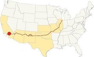
Location of South Pasadena on Route 66
The climate in South Pasadena is a Hot Summer Mediterranean one. Rather dry and hot in summer but cool and wet during winter (which can bring heavy rains), the January night temperature often falls just below freezing. Spring is warm and Summers are hot, with high temperatures extending into October which brings a short Fall, cool and hot, erratic.
South Pasadena has some 290 sunny days each year and during fall (autumn) strong dry winds blow from the desert (Santa Ana winds) drying out the area and increasing the risk of wildfires in the foothills.
The summer average high is 89.4°F (31.9°C) and the average low is 61.1°F (16.2°C).
During winter the average high is (Jan) 67.8°F (19.9°C) and the average low is 44.3°F (6.8°C) in winter, the peaks of the San Gabriel Mountains receive snow. You may experience some frost during winter (Dec. to Mar.)
Rainfall averages 21 in. per year (535 mm), most rain falls during the period from November to April, the rest of the year less than 0.5 in. falls monthly. There are 43.8 rainy days yearly.
Tornado risk
South Pasadena is located very close to the Pacific Ocean and well beyond the Rocky Mountains which are the western limit for tornadoes, so there is no risk. Tornado Risk: read more about Tornado Risk along Route66
Map of Route 66 near South Pasadena
>> Custom map alignments of US66 in this area
And our two other custom and interactive maps:
National Old Trails Highway (N.O.T.)
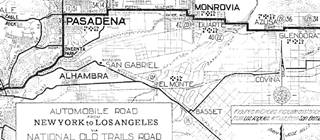
1912 N.O.T. Road map
Click on image to enlarge.
Credits
The 1910s N.O.T. highway system was aligned along Foothill Blvd and Colorado Blvd. into Pasadena from San Bernardino as it approached Los Angeles along its transcontinental course from New York.
The N.O.T. map (click to enlarge) shows its alignment across this area, it can be seen turning south into South Pasadena along Fair Oaks Ave. and Huntington Dr. south of Pasadena as it heads into Los Angeles and finally Broadway.
Route 66 Map
In 1926 Route 66 was aligned along the state highways all the way to Pasadena. The following map shows the highway in the Los Angeles region in 1927. You can follow Route 66 from Victorville in the east, to San Bernardino and west to Pasadena and Los Angeles. Pasadena is on the lower left side. South Pasadena does not appear in this map.

1927 Road map, SW CA
Click on image to enlarge.
Credits
The black and white 1930 thumbnail map above also shows the alignment of Route 66 from Victorville to Los Angeles notice the detail with the alignment across South Pasadena into Los Angeles is the one described further up and coincides with the N.O.T. alignment.
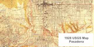
The other map was published in 1928; it shows Route 66 into Pasadena and then a fork, one highway crosses Arroyo Seco in Pasadena and enters Eagle Rock, the other follows Fair Oak, Mission St., crossing the Arroyo Seco in South Pasadena into the Los Angeles' Garvanza neighborhood. But no shields are shown.
There were several alignments of Route 66 from Pasadena into Los Angeles during the period spanning 1926 to 1940. It was only after 1940, when the Arroyo Seco Parkway became the route for US 66 into LA that these changes stopped. Contemporary maps don't clearly mark the course of US 66 into LA, and we have written extensively about it in our Pasadena to Santa Monica alignment webpage.
Our custom maps show these alignments, one through South Pasadena, another through Eagle Rock.
Finally there was an Alternate Route 66 alignment from Los Angeles into Pasadena along N Figueroa St. and Colorado Blvd.
Route 66 Alignment near South Pasadena
With maps and full information on the Mother Road.
- Pasadena to Santa Monica (South Pasadena's)
- Topock to Barstow (Previous)

South Pasadena's Attractions
Historic Context
South Pasadena does not appear in Rittenhouse's Guidebook to U.S. Highway 66 published in 1946. The 1939 A Guide to the Golden State by the Works Progress Administration only mentions it in reference to Pasadena: "PASADENA... Its southern limits are separated from Los Angeles by the small communities of South Pasadena and Alhambra."
Route 66 tourist spots
Begin your tour on the north side of town, driving south from Pasadena along the National Old Trails alignment along Fair Oaks Avenue. After passing the electric plant, and crossing the railroad tracks, to your left on the 1200 block, is a hill, site of a famous hotel.
Raymond Hotel
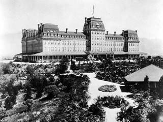
First Raymond Hotel, c.1890. Source
Click for St. view.
Walter Raymond (1851-1934) was born in boston and worked in the travel business. He came to California in 1883 to set up a luxury hotel and resort for Bostonians who wanted to escape from the winter chill of New England.
He built his 200-room Royal Raymond Hotel and resort on the top of Bacon Hill, now known as Raymond Hill; it gave its guests a 360° view of the surrounding scenery. It offered a balmy and luxury spot for wealthy East Coast visitors during winter.
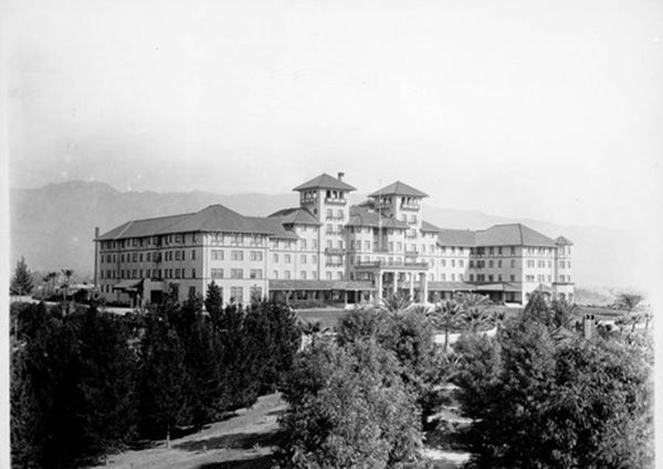
It caught fire and burned to the ground in just 20 minuteson Easter Sunday, 1895. A new hotel was built in 1901. It included a nine-hole golf course.
President Theodore Roosevelt stayed here in 1903. But, the Great Depression ion 1929 caused a drop in visitors and the hotel closed. In 1934, after Walter's death the hotel was torn down by the bank that had repossessed it. All that remains of the hotel are the old palm trees that line Raymond Hill Rd. at the top of the hill (St. view and map with directions).
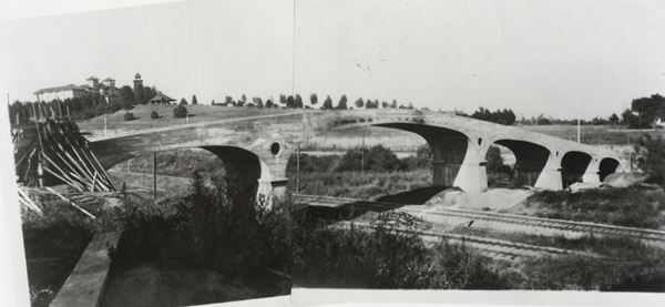
Oaklawn Bridge and Waiting Station
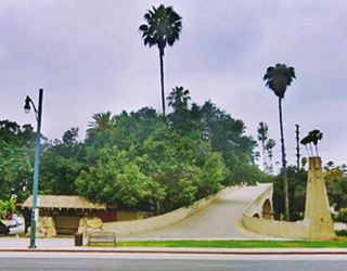
Continue south for 0.3 miles, and at Fair Oaks Ave and Oaklawn Ave., to your right you will see a Route 66 Attraction: Oaklawn Bridge
Route 66 Attraction and South Pasadena Cultural Landmark
This bridge predates Route 66 by 20 years; it was built in 1906 by Charles and Henry Greene and is a concrete bridge that crosses over the Santa Fe railroad tracks.
It spans 340 ft. with five reinforced concrete spans -one of the first bridges built with reinforced concrete in the US. It included a waiting station for those who travelled on the streetcar that ran along Fair Oaks. Below is a view of the bridge while it was being built in 1906 and looks northwards. The Raymond Hotel is in the distance (upper left side of the picture).
Just ahead, Fair Oaks Ave. crosses the Arroyo Seco Parkway that carried Route 66 from 1940 to 1964.
Arroyo Seco Parkway
You can continue south along the westbound lanes and drive the Arroyo Seco Parkway into Los Angeles. It begins in Pasadena and continues through South Pasadena into Los Angeles, after Glenarm Street it becomes a divided freeway.
Listed in the National Register of Historic Places. National Civil Engineering Landmark. National Scenic Byway. California Historic Parkway.
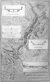
Arroyo Seco Parkway 1936 map rendering. Source.
Click image to enlarge.
Also known as the Pasadena Freeway, it runs south from Pasadena along what used to be Broadway, curves around the eastern and southern sides of Raymond Hill, and then runs west towards the Arroyo Seco River across South Pasadena, heading into Los Angeles.
It had 6 lanes and was designed for 27,000 automobiles per day (it now carries over 120,000 cars daily). It was the second superhighway in the nation, preceeded by the Pennsylvania Turnpike, a tollway that opened on October 1, 1940. It is the first freeway in America when it opened on December 30, 1940.
We describe it in detail in the Arroyo Seco Parkway section of our Pasadena webpage.

>> Learn more about the Historic Arroyo Seco Parkway
Flores Adobe House
Listed in the National Register of Historic Places. Cultural Heritage Landmark of South Pasadena
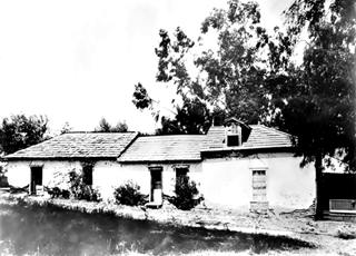
Flores Adobe c. 1900, South Pasadena. Source
Click to enlarge
Two blocks east, on the outisde of the curve described by the Pasadena Freeway around Raymond hill is South Pasadena's oldest building.
It is private property, on a dead end street, so it can't be visited or toured. Located at Flores Adobe 1804 Foothill St. South Pasadena (Map showing where it is).
It was known as la casa de Jose Perez (Jose Perez's home), who built it. Perez sold it to General Manuel Garfias ca. 1839, who also owned the Rancho San Pascual. It originally had an "L" shape that became a "U" when a woodframe wing was added around 1860. It was built in adobe, that is, mud and straw bricks dried in the sun.
After being defeated during the Mexian - American War, in the final battle of La Mesa (Jan., 1847), José María Flores retreated to his headquarters at the adobe and drafted what would be the Articles of Capitulation, a cesase fire known as Campo de Cahuenga Treaty. The adobe was named after him.
Later, the home passed into the hands of a Dr. Griffith. It was restored by Mrs. Clara Eliot Noyes in 1919 who hired Carleton Winslow an architect for the project. In the 1930s it was acquired by the Marshall Neals who lived here until they passed away.
Gus's Barbeque - classic Sign
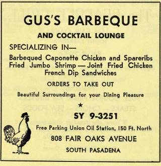
Gus's Bar B Cue Advertisement 1955-56 Source
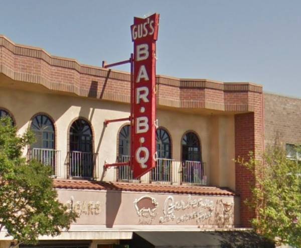
Continue south along Fair Oaks and you will reach the commercial district of South Pasadena. To your left at 808 Fair Oaks Ave is a classic restaurant with a great neon sign.
It is a steak restaurant that has been open since 1946 and cooks its BBQ over pecan logs.
Their advertisement in the 1955-56 city directory tells us they offered take out, and had free parking 150 ft. north at the Union Oil Station.
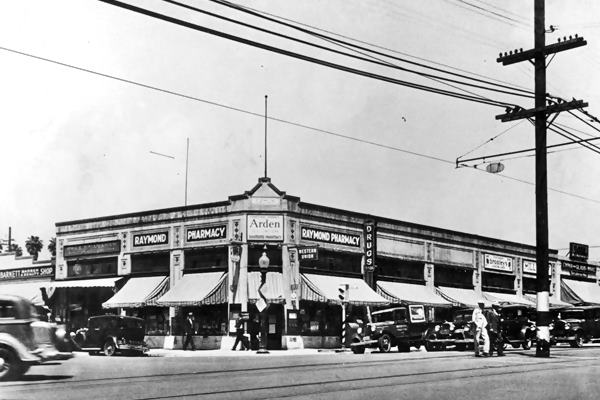
Fair Oaks Pharmacy and Soda Fountain
Head south; on the following corner, to your right is the Fair Oaks Pharmacy and Soda Fountain at 1526 Mission St. NW corner with Fair Oaks Ave.
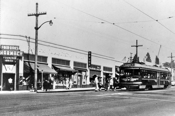
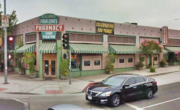
Back in the early and mid 1900s, the pharmacy not only sold medicine and filled prescriptions; they offered a wide range of services, from candies and gifts to milk shakes.
It opened in 1915 under the name of "South Pasadena Pharmacy" and later became the Raymond Pharmacy. During the 1920s, Route 66 passed right in front of its doors.
It was restored in the 1990s and became Fair Oaks Pharmacy & Soda Fountain. It is worth stopping by to see its vintage interior and the original soda fountain. You can order our malts, shakes, sundaes, or eat a hamburger. The place also sells vintage and unusual candy. Below are some "Then and Now" views of the building.
Rialto Theatre
Listed in the National Register of Historic Places
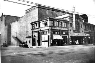
Rialto Theater 1933, South Pasadena. Source
Click to enlarge
Two blocks further soth, on your right is the Historic Rialto Theatre at 1023 Fair Oaks Ave.
It was built in 1925 following a Spanish Baroque style with Moorish details. The theatre could seat 1,200 people and had beautiful ornaments decorating its interior.
Rialto is the contraction of the Italian words "Rivo Alto" or "high" and "river" which was a mudflat where Venice, Italy, was founded. The island became the mercantile quarter of medieval Venice so the name Rialto became a synonym for "business district".
The Rialto Theatre featured prominently in the Academy Award and Golden Globes winning movie LA LA Land (2016) starring Ryan Gosling and Emma Stone.
Historic Rialto Theatre
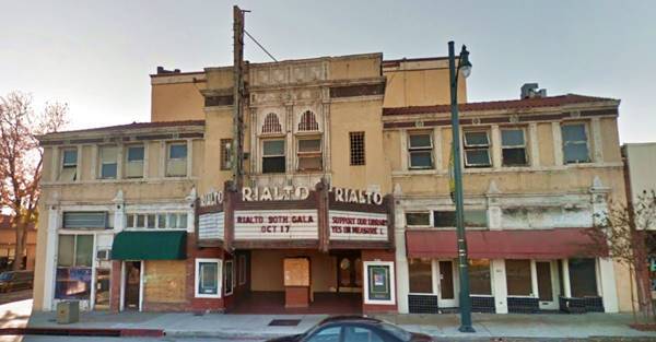
Vaudeville shows and later films were played in the theatre until the mid 1930s, and after that only films.
It suffered two fires, on in the 1930s and another in 1968. It was almost torn down for redevelopment but local activists had it listed on the National Register of Historic Places in 1978.
It closed for good in 2007. And its listing as a historic place has saved if from being demolished. As it is supposedly haunted, the ghosts that inhabit it must be delighted.
Short Tour of Other Local Landmarks
See this map with directions, driving along Mission St., that carried Route 66 and visiting tow wacky spots.
South Pasadena Museum
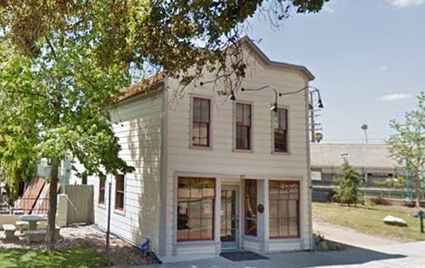
Turn south half a block to visit the museum at 913 Meridian Ave. It is housed in a very old building from the 1890s, the "Meridian Iron Works", It has a collection of artifacts that portray the history of the region.
Old Meridian Iron Works building in South Pasadena
Return to Mission Street, and here after crossing the tracks, to your right is the Halloween House.
Halloween Movie house
City Landmark and Movie famous location
On the corner at 1000 Mission St. On the north side of the tracks (Mission St. and Meridian Ave.)
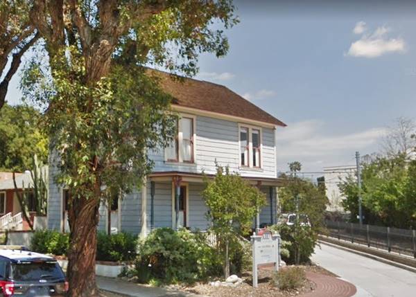
This house, known as "Century House", was built back in 1888 when the city incorporated. It is one of the oldest buildings in South Pasadena. It is also the location of the 1978 movie "Halloween".
Director John Carpenter shot the low budget horror film here in 1978, it was the first "Halloween" movie. In it, murderer Mike Myers breaks loose after being hospitalized for 15 years and causes a blood-bath among the teens in his hometown. A classic that only cost $400,000 and grossed over $70 million. See this Video trailer showing the house.
The building was moved here from its original location at 709 Meridian.
Century House location of the 1978 film "Halloween"
Cawston Ostrich Farm
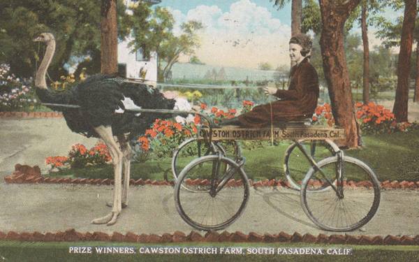
Continue westwards along Mission St. at Sycamore Ave. SW Corner (101 Mission St) is the site of the ostrich farm. There is a marker by the spot.
Edwin Cawston, an Englishmen born in 1866 created his ostrich-breeding farm in Norwalk, CA in 1886, and his famous South Pasadena Cawston Ostrich Farm in 1896. Many Angelenos took the red streetcar to South Pasadena to visit the farm and see how the ostriches were fed oranges, ride them bareback and visit the feather processing plant where they were cleaned and dyed. In the early 1900s these "plumes" were used in women's hats, boas, fans and capes. The farm had 200 specimens that were plucked for this purpose. The factory and store is a South Pasadena Cultural Landmark.
Cawston died in 1920 at the age of 54, but the farm remained a successful business until the the Great Depression. It closed in 1935. There is a plaque on the site (St. view) on Pasadena Ave. close to its corner with Sycamore Ave.
Trivia: South Pasadena Celebrities
Hilary Swank, Academy Award-winning actress; William Holden, Academy-Award winning actor; Joel McCrea, actor; David Lee Roth, member of Van Halen, singer.
Continue your Road Trip
End of this leg of yor Route 66 road trip. This completes the drive across South Pasadena
Head west along the Pasadena Freeway to continue your Route 66 road trip in neighboring Los Angeles.

Sponsored Content
>> Book your Hotel in Santa Monica

Credits
Banner image: Hackberry General Store, Hackberry, Arizona by Perla Eichenblat
A Guide to the Golden State; Federal Writers' Project of the Works Progress Administration, Hastings House, New York, 1939.
Jack DeVere Rittenhouse, (1946). A Guide Book to Highway 66.


