Table of Contents
Index to this page:
- California Route 66 Itinerary and maps
- Historic background of this segment
- Barstow to Victorville
- Victorville to Cajon Pass
- Across Cajon Pass
- San Bernardino
- City 66 and Alt 66 in San Bernardino
- San Bernardino to Glendora
- Pasadena
- Hotels
>> See our custom interactive Map of this segment.
Barstow to Pasadena CA, itinerary and alignment
California Route 66 Itinerary and maps
Each leg of Route 66 described below has an interactive map and many image maps so you can follow the alignments of the highway along the way:
- Topock to Barstow - Map of this segment
- This leg: Barstow to Pasadena - Map of this segment
- Pasadena to Santa Monica - Map of this segment
Santa Monica End of the Trail!
Arizona, previous leg
Barstow to Pasadena along Route 66
Historic Background of this section of US Highway 66
Route 66 was created in 1926 and it used pre-existing highways as its first alignment. The original highway in the area was the "National Old Trails" a private sponsored highway created in the 1910s. It was known as an "Auto Trail" and formed part of the publics demand for "better roads"; a movement that lobbied for good highways that could be used by motor vehicles, and also signs to mark them and help drivers to find their destination.
The thumbnail (Click to see large size map), shows some of the "Auto Roads" or "Auto Trails" that were good enough to be driven by cars back in the 1920s.

1927 Road map, SW CA
Click on image to enlarge.
Credits

1956 Shell Roadmap, SW CA
Click on image to enlarge.
Credits

From Barstow to Pasadena along Route 66
How much of Route 66 is still driveable in California?
Many people ask us:
>> How Much Of Route 66 Is Still Driveable In California?
Answer: Over 95% of Route 66 in California is still driveable.
The Alignment of Old Route 66 from Barstow to Victorville
The first road through Victorville was the National Old Trails (N.O.T.) road which was a highway that was projected to link New York and Los Angeles in the early 1910s. This road ran close to the Santa Fe Railroad between Victorville and Needles. This is a simple route, and a relatively intact one too. Just head west from downtown Barstow along Main St., and stick to it.
It passes through neighboring Lenwood, Hodge and Helendale in a wide sweeping curve towards the west in the Mojave desert, running next to the old SF Railway and the Mojave River just beyond it.
Mojave River
The river is located roughly 1.5 to 2 miles west of Lenwood. The Mojave is an itermitent river that flows in a closed basin with an area of 4,580 sq. mi. (11.862 km2), its source is in the San Bernardino Mountains at almost 3,000 ft. altitude (900 m) and it discharges into Soda Lake, in the Mojave Desert.
It is a source of water used by the desert animals and plants, and also by those crossing the Mojave since prehistoric times.
110 mi long (177 km), its discharge varies from nil to a maximum of 70,600 cu. ft. (2.0000 m3). Most of its water flow is underground as the river bed is dry most of the year.
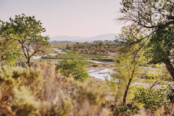
Father Garces named it Arroyo de los Mártires (Martyrs' Creek) in 1776. When Jedediah Smith followed it westwards into California in 1826 he named it "Inconstant River".
The underwater course of the Mohave River was marked by vegetation growing next to it, and therefore was in sight of Route 66 and the SF Railroad all the way from Newberry to Victorville andi in its last section, past Oro Grande, it was a visible water course.
After Helendale, the road swept towards the southeast, crossing the railroad tracks using an underpass at Oro Grande and, after crossing the Mojave River on the steel truss Oro Grande Bridge, it heads straight into
Victorville along D Street and turning right (south) along 7th Street, which it followed until leaving town.
The driveable segment ends at the junction of Green Tree Blvd. and 7th St. by Exit 150 of I-15.
This alignment is shown in this custom map with directions (pale blue line).
The Alignment of Old Route 66 from Victorville to San Bernardino
Victorville to Cajon Pass
This alignment is shown with a burgundy line in our custom map.
Leave Victorville from Green Tree Golf Course by I-15 Exit 150. The original roadway is buried by the four-lane freeway (I-15) built on top of the original alingment.
At Exit 143 was the site of the Miller's Corners service station mentioned by Jack Rittenhouse, on the Main St. into Hesperia, a town that is located 4 miles east.
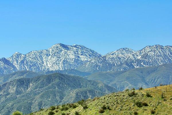
Keep southbound, and at Exit 138 the old road headed to the eastern side of the present I-15 at the foothills of the mountains, with San Bernardino Mountains to the east, Cajon Pass in the middle and the San Gabriel Mountains to the west. This is where the San Andres Fault cuts across the mountains marking the tectonic boundary between the Pacific Plate and the North American Plate.
Across Cajon Pass
See the our custom map, there are many alignments in the pass.
>> visit our Cajon Pass page where we describe the alignments in detail.
Starting at Exit 138, cross to its eastern side and head west along Mariposa Rd., west of the gas station was the famous Summit Inn. Mariposa Road follows the course of the original Route 66 alignment here, we marked it with a brown line in our custom map. It carried the National Old Trails highway from 1915 to 1926 and Route 66 from then until 1968.
Ahead is the alignment that carried the highway from 1930 until 1952, marked with a violet line in our custom map. This roadway can still be seen, the asphalt cracking under the desert's sun.
The highway was realigned again when Route 66 became a 4-lane highway. This alignment is marked with a pink line in our custom map.
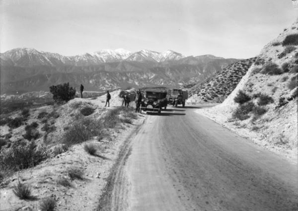
The photo above was taken by A.G. Lucier on Oct. 23, 1920 on the "National Park-to-Park Highway tour" at a lookout on the original roadway of the National Old Trails. It was a narrow meandering highway even though it had been widened to 16 ft. and it had been paved with oiled macadam since 1916.
This alignment is marked with a red line in our custom map.
Route 66 was aligned along the N.O.T. roadway in 1926 and used it until it was upgraded to a new alignment in 1930. Below is a picture taken along then new roadway, and the spot is roughly in the spot shown in this map
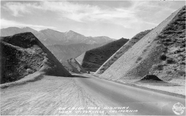
Road Improvements
The new roadway was widened further to 20 ft with 5 foot-wide shoulders, eliminating many of the curves (1930 to 34).
The yellow line in our map shows the two lane U.S. 66 alignment.
Divided Highway in the 1950s
Route 66 was widened to a four lane divided highway across the pass between 1952 and 1955; the second set of lanes is marked with a green line in our custom map, north of Cajon Junction, and with red, blue and yellow lines west of that point.
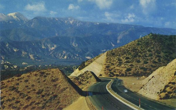
But the highway was not up to the Interstate standard. Traffic grew, peaking in 1960 with over 1.1 million travellers driving through Cajon Pass that year. A new safer road was needed and it was finally built: I-15. With two separate alignments in this part of the pass. It was constructed eastwards from the foot of Cajon Pass through Victorville to Barstow in 1958. Then across the Pass into San Bernardino in 1971-72.
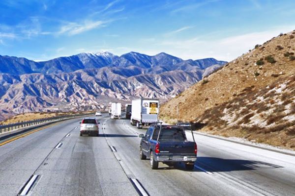
The original 1926 to 1930s alignment is mostly gone as you can see in our custom map, it crisscrosses the freeway several times on its way up towards the summit and then downhill on the southern side of Cajon Pass.
The construction of I-15 eliminated most of the old roadway, but at Exit 129, you drive along it as it became Cajon Blvd. where you can still see the stone wall that dates to the 1930s and served as a crash barrier, keeping cars from falling down the cliffs in a period when guard rails hadn't yet been invented.
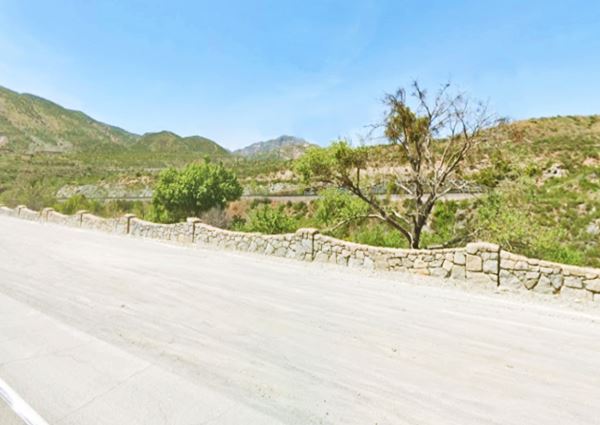
Cajon Blvd. runs on the southern side of I-15 all the way to the community of Devore.
Devore
The alignment of U.S. 66 is cut off at the junction and interchange of I-215 and I-15 that interrupt the old alignment. On the southeastern side of the freeway, it continues with a NW-SW course into San Bernardino once again along Cajon Blvd.
Alt 66 and US 66 split ways
Here in Devore, the highway split into an Alternate and a Main, or "City" 66.
San Bernardino to Glendora
San Bernardino

Detail 1930 roadmap
Click on image to enlarge.
Full map
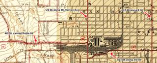
The thumbnail map shows the 1930 alignment of Route 66 from Victorville to Los Angeles, it enters San Bernardino along Mt. Vernon and then leaves along 4th St. More on this below where we describe the City or Main 66 and the Alternate 66 alignments.
The Two Route 66 alternatives into San Bernardino
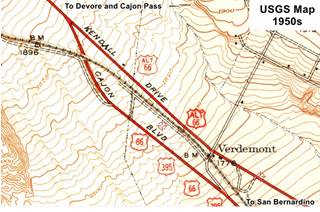
Prior to the early 1950s when US 66, US 395 and US 91 were realigned along a "four-lane" highway running where I-215 now runs, the Mother road had two alignments into San Bernardino: City 66 and Alternate 66, they split 1.5 miles SE of the interchange of I-15 and I-215 at Verdmont.
The one that ran along Cajon Blvd. and Mt. Vernon Ave. (City 66) accompanied US 395, while the other ran further east, along Kendall Dr. and E St. up to 5th St. where it turned right and went through downtown San Bernardino (Alt 66).
Rittenhouse in his Guidebook to U.S. Highway 66 that he published in 1946 recommends taking the take the City alignment "through the edge of San Bernardino. At the center of a small business district US 66 turns right and heads almost straight west toward Los Angeles, about 53 miles distant. From this point on, the traveler is practically "in" Los Angeles. Tourist camps of the best type, fine cafes, and other roadside facilities are found all along the way, so no further detailed description is necessary". He adds that there are 12 towns between San Bernardino and Pasadena and that "Many of them are so close together as to be practically indistinguishable from each other".
Alternate US 66
The American Association of State Highway and Transportation Officials (AASHTO) created the "Alternate" designation in 1959. Its purpose was to designate a route that branches off from the main highway, passes through given towns or cities and then connects again with the main numbered route. The idea is to accommodate a high traffic demand.
When the Alternate and Main highways followed a similar course, the shorter and better built highway would be marked as main and the other as alternate.
There are only six places along Route 66 where an Alternate 66 alignment existed: From East to West they were the one into Chicago, Carthage MO, the one in Joplin MO, Oklahoma City, Alt 66 in San Bernardino, California, and the one leading into Los Angeles CA.
There were, according to the USGS maps, two Route 66 alignments into San Bernardino: the "Main" U.S. 66 along Cajon Blvd. and Mt. Vernon Ave. and Alternate 66 further east, along Kendall Dr. and E St and into downtown San Bernardino.
- Main 66. It shared it with U.S. 395 and U.S. 91. We marked its course with pale blue line in our custom map. At 4th street it turned west (the orange line in our map). Later it moved to 5th St. in the 1950s, red line. By 1969 when Route 66 was aligned along what now is I-215 (it was I-15 at that time), Route 66 entered San Bernardino along the freeway (San Bernardino-Barstow Freeway) and left it at Exit 43, onto 5th St. (yellow line).
- Alternate 66. It entered San Bernardino along the course marked with a dark blue line in our map, along Kendall Dr. and E St. Then its original alignment westwards was along W 4th and W 3rd Streets along the south side of San Bernardino Depot. Then north along N Mt Vernon Ave as shown with a violet line in our custom map. However it moved to 4th St. in the 1950s (light blue line).
Crossroads on Route 66 and Alt 66
Ahead, the original Route 66 turned west (right) along 5th Street that one mile west continued towards Los Angeles as Foothill Boulevard. This area is now cutoff, and part of a container yard. Here it met ALT 66 that curved around the south side of San Bernardino's railway depot. By the early 1950s, both Alternate and Main 66 were realigned along 5th Street. Click on the thumbnail map to enlarge it and view these alignments.
From San Bernardino the highway took a straight a westward course along Foothill Boulevard into Rialto, Fontana and the other towns that lie on that road.
Route 66 From San Bernardino to Pasadena
See the red line in our custom map.
In the 1940s and 1950s, Leaving San Bernardino Route 66 crossed farmland with orange groves running along Foothill Blvd. westwards until it reached Glendora.
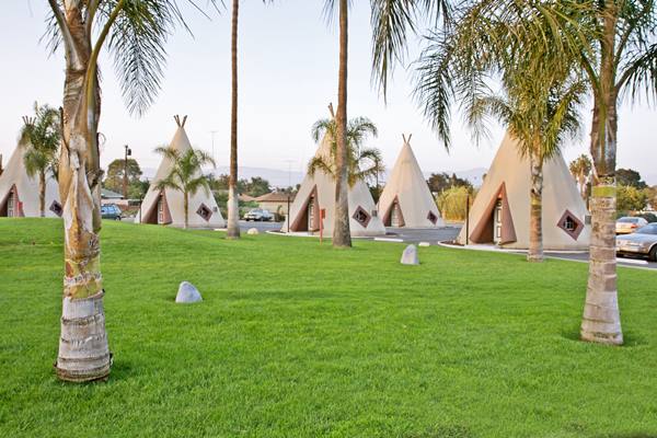
It passed by the towns mentioned by Rittenhouse and others that didn't even appear in the maps at that time: Rialto, Fontana, Rancho Cucamonga, Upland, Claremont, Pomona.
>> red line is the 1926-70s alignment here.
La Verne and San Dimas 1930s Realignment
>> orange line is the 1926-30s alignment in West La Verne and San Dimas.
In La Verne and San Dimas, the highway was realigned.
The USGS map from 1928 (click on it to enlarge it) shows that Route 66 had a different course west of the intersection of Baseline Rd. and Footill Blvd. on the western edge of La Verne. Route 66 curved at this point leaving its SE-NW course and headed with a straight west direction along E Baseline Rd. up to N San Dimas Rd. where it turned sharply north, crossed San Dimas Wash, and then followed the SE-NW course of Foothill Blvd.
But the highway was realigned to avoid all these sharp turns when a new alignment was built to span the gap and extend Foothill Blvd. across San Dimas Wash here in the early 1930s.
Glendora
The next town, Glendora had an older alignment, used from 1926 to 1933, and it is marked with a light blue line in our custom map.
New Glendora alignment from 1933 to 1964
>> red line is the 1933-64 alignment across Glendora.
The USGS map from 1939 (click on it to enlarge it) shows the first alignment along E Foothill and the later one, along Alosta Ave., further south. It avoided the sharp 90° turns and the grade crossing of the Santa Fe tracks in downtown Glendora (an underpass was built on the new alignment). Construction had to wait for the dams and hydraulic works to be completed in the Mountains, to make San Dimas and Big Dalton washes controlled streams that could be bridged.
The new roadway kept west along the brand new Alosta Ave., and after crossing Barranca Ave. entered Azusa where both old and new alignments met at the junction of Foothill Blvd and Alosta Ave.
Westwards from Glendora
The highway continues west along E. Foothill through Azusa and Irwindale where the road changes its name to Huntington Dr.
The USGS map from 1928 (click on it to enlarge it) shows the first alignment along E Foothill into Azusa from Glendora. Alosta Ave. that carried the 1933 realignment wasn't paved at this time and didn't cross the Little Dalton Wash. The highway runs straight across Azusa, which was only 10 blocks long. The rest was orange groves and fields. Then it curved to the NW to cross the wide wash of San Gabriel River. It then took an east-west course passing north of Duarte and taking an alignment along Highland Ave (violet line in our custom map).
Route 66 passes through Duarte and reaches Monrovia. The map below shows the National Old Trails alignment in this area.
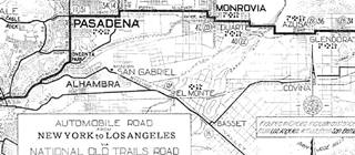
1912 N.O.T. Road map
Click on image to enlarge.
Credits
The map above, from 1928 shows Route 66 running from Duarte, across Monrovia, Arcadia, south of Sierra Madre, and into Pasadena. At that time the highway ran along Foothill Blvd. north of the later alignment that ran further south along Huntington and Colorado that was built in 1933. Until then it ran along the course marked with a green line in our custom map.
Pasadena, end of this segment
In 1932 Huntington Dr. was built and paved between Duarte and Arcadia along the southern side of Monrovia into Arcadia and Route 66 was aligned along it in 1934. As marked with a red line in our map. West of Arcadia it ran along Colorado Pl and Colorado St. both were built at for this purpose between Arcadia and eastern Pasadena. The highway went by and Sierra Madre entering Pasadena, the endpoint of this segment.
Next Section, final one of Route 66
Pasadena is the end of this segment, ahead are the different roadways Route 66 took into Los Angeles (1926-35 western terminus) and beyond, towards the "End of Route 66 in Santa Monica (1935-1964).
Next Section
>>The next section in our Road Trip itinerary is its final one: Pasadena to Santa Monica
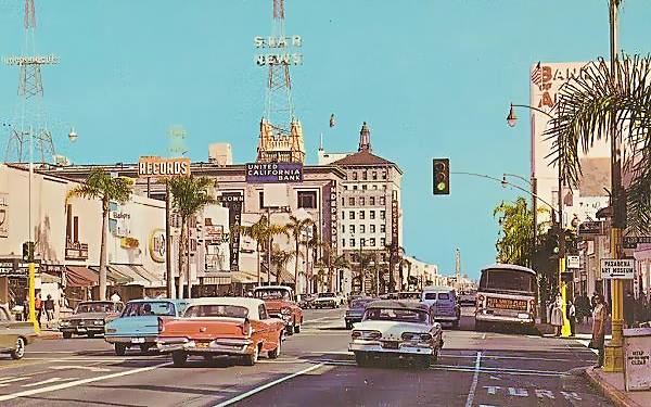
The Decommisioning of US 66 began in California in 1964

End of Route 66 moves to Pasadena, 1964. Source
Terminus moved in 1964 From Santa Monica to Needles
On Aug 26, 1963 the state's Higway Commission requested the "Elimination of Route 66... Between Jct. U.S. 95 Needles and Santa Monica" it was approved by the AASHO on Nov. 14, 1963. At the same time the state had also requested eliminating Alt 66 from Pasadena to Los Angeles through Eagle Rock. This was also authorized. 1
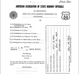
End of Route 66 moved from Santa Monica to Needles, 1964. Source.
Click image to enlarge
The first segment of Route 66 to lose its certification was the one located in Los Angeles County in 1964, it was replaced by State highways Route 2 and Route 11.
The western terminus of Route 66 was "officially" moved from Santa Monica to Needles in 1964 using I-15 and I-40 all the way from San Bernardino to Needles. However, the state's Highway Commission included the alignment of Route 66 between Pasadena and Needles in its maps until 1970 co-signed with state hwy. 248 (see the maps.)
Hotels along this leg of your road trip
San Bernardino has plenty of lodging options for those travelling along Route 66, you can book a hotel or motel there:
>> Book your Hotel in San Bernardino
More Accommodation nearby along Route 66
Continue your Route 66 Road trip:
Route 66 Alignments
Next Section
Route 66 from Pasadena to Santa Monica (The End of Route 66).
Previous Section

Sponsored Content
>> Book your Hotel in Pasadena


Credits
Banner image: Hackberry General Store, Hackberry, AZ by Perla Eichenblat
Jack DeVere Rittenhouse, (1946). A Guide Book to Highway 66.
1. Route Numbering Archive AASHTO file Other (49).PDF, search terms: Route Number: 66.


