The Grand Canyon and Route 66
Index to this page
About Grand Canyon, Arizona
Facts, Trivia and useful information
Technically the Grand Canyon isn't on Route 66. It is a short drive north of it. You can reach it from either of these two towns:
- 59 miles from Williams
- 78 miles from Flagstaff
Some figures to grasp its size
The Grand Canyon is a natural wonder; the Colorado River carved through a thickness of one-mile of solid rock creating a dramatic canyon over 200-miles-long:
- The Grand Canyon National Park (which does not include the whole Canyon), is larger than Rhode Island (1,904 sq.mi. vs 1,212 sq. mi.)
- It is 18 miles (28.8 km) wide at its widest, and only 600 ft (180 m) at Marble Canyon
- Depth, on average 1 mile (1.6 km)
- 5.9 Million visitors come each year to the Grand Canyon (a good reason to plan your visit carefully)
- Length of the Colorado River in the park: 278 river miles (447 km)
- It begins at Lees Ferry (see it on the map) and ends at the Grand Wash Cliffs (see it on the map)
- Elevation of the South Rim 7,000 ft (2,100 m), the North Rim is 8,000 feet (2,400 m)
- Volume of rock exavated by the river: 5.45 trillion cubic yards (4.17 trillion m3)
The narrow section of the Grand Canyon, south of Lees Ferry bridged by US 89 at Navajo Bridge
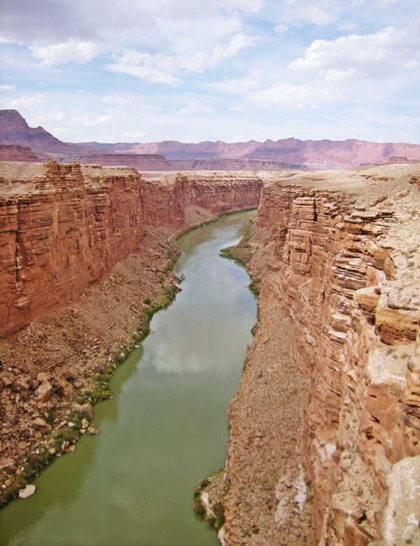
When did it become a National Park?
It has an ancient history, dating back to prehistoric times, but the attempts to preserve its natural beauty are quite recent:
- 1893: President Benjamin Harrison designated it as a "Forest Reserve"
- 1903: President Theodore "Teddy" Roosevelt visited the park, its unique landscape struck him
- 1906: President T. Roosevelt proclaimed it as the "Grand Canyon Game Reserve"
- 1908: President T. Roosevelt: designated it as "Grand Canyon National Monument"
- 1919: Congress designated it as the "Grand Canyon National Park"
- 1979: UNESCO designated the area as a World Heritage Site
Teddy Roosevelt's speech in Flagstaff, about the Grand Canyon, May 6, 1903:
I have come here to see the Grand Canyon of Arizona, because in that canyon Arizona has a natural wonder, which, so far as I know, is in kind absolutely unparalleled throughout the rest of the world.
...
I shall not attempt to describe it, because I cannot. I could not choose words that would convey or that could convey to any outsider what that canyon is. I want to ask you to do one thing in connection with it in your own interest and in the interest of the country: to keep this great wonder of nature as it now is. Teddy Roosevelt (1903)

Accommodation: Where to Stay in the Grand Canyon Area
Find your room in the motels in Grand Canyon (sponsored content):
>> Book your room in Grand Canyon Region
More Accommodation near the Grand Canyon on Route 66
There are plenty of lodging options in the cities and towns along Route 66. Click on the links below to find your accommodation in these towns, listed from east to west:
Eastwards
In Arizona Along Route 66
Westwards
You are so close to Las Vegas!
The Weather in the Grand Canyon

Location of Grand Canyon AZ close to Route 66
The Grand Canyon Influences the weather
There are great changes in elevation from the Colorado river at the bottom of the Grand Canyon to its rims. The deep lateral canyons and gullies and the terrain also influence how air circulates and how the sun heats the terrain.
As a rule of the thumb, the lower you are the warmer it is: for every 1,000 ft. you drop, the temperature increases by 5.5°C (3°C every 300 m).
The low relative humidity of the area (it is very dry) makes for clear skies and the sun can be felt strongly. At night, the same situation provokes rapid heat loss.
There are great day-to-night temperature swings.
Summer
During early summer the relative humidity can drop to less than 10% during daytime. But as the season advances moist air from the Gulf of Mexico and the Gulf of California produces a "Monsoon Season" with sudden cloud buildup, thunderstorms, downpours and flash floods in the usually dry streams that flow into the Grand Canyon.
Winter
Snow falls on the rims, but melts away to rain before reaching the canyon floor.
Most snow (142" per year - 3.6 m) falls on the North Rim; the South Rim receives 58" (1.5 m).
Temperature
For the South Rim: Winter Highs (Jan) average 41°F (5°C) and the Lows are 18°F (-8°C). Summer Highs (Jul) are 84°F (29°C) and the Lows are 54°F (12°C).
Risk of Dehydration and heatstroke
Keep Safe

Dehydration
Excessive loss of body fluids can seriously harm you. Know the signs, causes, and symptoms of dehydration. How to prevent it and treat it.
During summer, late spring and early fall make sure you stay hydrated. The hot and dry desert climate can dehydrate you quickly. Drink plenty of water and fluids; dress for the heat and the strong sunlight to avoid fluid loss and sunstroke. Protect your skin from sunburn with adequate solar filters.
Route 66 to the Grand Canyon map
From Flagstaff, follow the directions given in the map. If you are coming from Williams, use this map.
Route 66 crosses Arizona from east to west, and the Colorado River enters the state from the north and then curves west. Route 66 runs to the south of the river, and the Grand Canyon. Then both turn south and U.S. 66 crosses it at Topock, to enter California.
Getting to Grand Canyon
You can reach Grand Canyon along Interstate 40 and Old Route 66 in Arizona. From Williams take AZ-64 and US 180 from Flagstaff. US 89 and 89A lead to the North Rim.
Route 66's Alignment near Grand Canyon
With maps and full information of the highway:
- Kingman to Topock (next)
- Williams to Kingman (Grand Canyon's)
- Winona to Williams (previous)
The History linking Route 66 and the Grand Canyon
History of the Grand Canyon
The oldest evidence of human presence in the Grand Canyon area daes back to almost 12,000 years. These were hunter-gatherers at the end of the last Ice Age known as Paleo-Indians.
More recently the Anasazi people, of Pueblo origin, built their adobe and stone dwellings in the area close to the canyon's rim. An example is the Tusayan Ruins or Tusayan Pueblo that began around 1,185 AD and was inhabited until a period of extreme drought forced them to move elsewhere areound 1,500 AD.

Prehistoric Grain storage caves on the Grand Canyon cliffs. Source
The oldest human artifacts found are nearly 12,000 years old and date to the Paleo-Indian period. The Hopi and Pueblo people are their descendants. Another group moved in to fill the void left by the Anasazi, they still live here, they are the Hualapai and Havasupai people.
In the sumer of 1540 the Spanish conquistador Francisco Vázquez de Coronado reached the area seeking gold and riches. The Hopi guided a party led by García López de Cárdenas to a "great river". They reached the south rim and stood there looking at the Grand Canyon for the first time. They tried in vain to reach the bottom and after 3 days returned to their base.
A Spanish Franciscan missionary, Silvestre Vélez de Escalante, rediscovered the Grand Canyon in 1776–77 while he tried to open a route between Santa Fe NM and Monterey CA.
After the United States annexed these territories after defeating Mexico in the 146-48 War, the government commissioned Captain Lorenzo Sitgreaves, to explore and map the Zuni and Colorado Rivers and learn if they could be navigated. The expedition stopped short of the Colorado River near what is now Winslow when Antoine Leroux, who was their unreliable guide, told them that the Little Colorado ran along a deep canyon and then met the Grand Canyon. Considering it too hazardous, Sitgreaves opted for an overland route (more or less where US66 would later be aligned).

1861 litograph of the Grand Canyon, Ives expedition. Source
In 1853, the U.S. Congress commissioned Amiel Weeks Whipple (1817 - 1863), a Captain of the Army Topographical Corps, to survey a proposed transcontinental railroad. He found it was feasible, so a wagon road was deemed necessary to supply labor and supplies for building the railroad. In 1857 U.S. Army officer Edward "Ned" Fitzgerald Beale was instructed to survey a route from Fort Smith in Arkansas to California.
At the same time Lieutenant Joseph Ives navigated upstream along the Colorado River in the steamboat Explorer and reached Boulder Canyon, He helped Beale's men cross the river and returned to Yuma.
Ives later explored the Grand Canyon at Diamond Creek, he wasn't amused by nature, he described it as:
"altogether valueless... It can be approached only from the south and after entering it there is nothing to do but leave. Ours has been the first and will doubtless be the last party of whites to visit this profitless locality. J. Ives (1857)
John Powell

1872 picture of the Grand Canyon and Colorado River, Source
One-armed Civil War veteran John Wesley Powell (1834-1902) navigated the Colorado River leading an expedition of four small rowboats. An epic expedition that set out in 1869 and after losing a boat at Disaster Falls and portaging rapids or running them, they ran low on supplies and faced more white water west of Diamond Creek. Three members of his expedition quit and abandoned the river; they were killed by the Indians. But the rest survived the ninety-eight day ordeal and were received by the Mormons wo had settled at Virgin River.
He led a second expedition in 1872 (see photo), and his comments about the beauty of the region prompted even more expeditions along the Grand Canyon.
The automobile and the Grand Canyon
The first tourists that ventured into the South Rim traveled by train to Williams and then by stagecoach to view the Grand Canyon. Soon a hotel was built (1897) and a rail link built from Williams to the South Rim (1901).
Just at that time the automobile entered the scene. Adventurous explorers began using cars to travel as tourists. The roads were terrible, mostly dirt surfaced, full of ruts and potholes, unmarked and without services. Courage was necessary to set out on a road trip in the early 1900s.
Santa Fe ⁄ Grand Canyon ⁄ Needles Highway

Map Williams - Grand Canyon, National Old Trails. 1916. Source
A private initiative promoting better highways was launched at that time and its goal was the National Old Trails Road Ocean-to-Ocean Highway. By December 1912 they had defined the different trails from the east to Santa Fe. They needed the final segment to the Pacific Ocean. The Southern California Automobile Association promoted such a link, from Los Angeles via Victorville, Barstow, Needles, and Kingman into Arizona. They claimed that:
It is generally conceded that this Northern route has many advantages over the southern roads and accommodations and is through a country of great scenic beauty. The scenery in the Arizona mountains cannot be excelled anywhere and the Grand Canyon stands alone as the most gigantic work of nature. The National Old Trails Road (2017)
In 1913 the association's constitution was ammended to adopt the Grand Canyon Route between Santa Fe and the Pacific Coast as the official route of the National Old Trails Road.
The thumbnail map (12a) is one of the two maps linking the N.O.T. with the Grand Canyon (the other map is 12b, the Flagstaff-Grand Canyon one).
Route 66 created in 1926
Being the best highway in the area, it was natural that as the usage of automobiles grew, the National Old Trails highway was improved in the early 1920s with State and Federal funds. Finally, in 1926 it was included in the alignment of the brand new U.S. Highway 66 from Los Angeles to Romeroville where it linked up with the Ozark Trail to continue east towards Chicago.
Route 66 and the Grand Canyon a long love affair

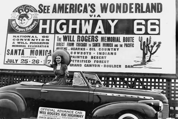
Will Rogers Highway's attractions (Grand Canyon), 1940s. Source
Route 66 was promoted not only as a great transcontinental highway, it also highlighted the natural attractions along it and among them was the Grand Canyon.
The promotional postcard and the image below from a 1940s Route 66 convention both mention "See the ... Grand Canyon" among other sights that included Indians, Cowboys, Petrified Forest, and Boulder Dam.
The guidebook "Arizona; a state guide" published in the late 1930s by the Writer's program of the Work projects administration (WPA) dedicated a segment to the highway "WILLIAMS JUNCTION to GRAND CANYON"; its starting point was Route 66: "State 64 branches north from US 66-89, ra., at a point 2 miles east of Williams (pictured below in a 1940s postcard), it described the cabins and gas station 8 miles north of that point, at Red Lake, and the whole itinerary to Grand Canyon Village.
Jack Rittenhouse mentioned it in his 1946 Guidebook to U.S. Highway 66: "Junction with paved road north to GRAND CANYON , which lies 58 miles north."
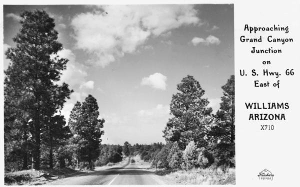
The junction was, in the 1950s quite impressive as you can see in the postcard below, captioned "Highway to the Grand Canyon and U.S. 66 - Williams, Arizona."
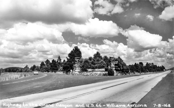
The photograph looks east, and between the two stone pillars is a sign with the words "Grand Canyon", and an arro pointing left, towards State Highway 64. Route 66 runs across the image from left to right.
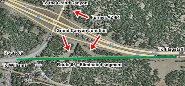
The Grand Canyon Junction nowadays. Click on image to enlarge or see Full size map
The thumbnail view (click on it to enlarge) shows the original alignment of Route 66 - green line (also in our custom map), and the remains of the original junction can still be seen as well as the slash of State Highway 64 north of the freeway (red arrows). The junction was erased when the freeway skirted Williams in 1984.1980 aerial photograph showing the junction att that time.
Williams
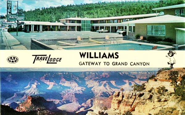
The town of Williams profited from the Grand Canyon starting back from the Railroad link in the early 1900s and later when Route 66 brought droves of tourists during the 1950s and 60s. It called itself "The Gateway to the Grand Canyon", all of the postcards mention this fact, below is an example of the Williams Traveldoge:
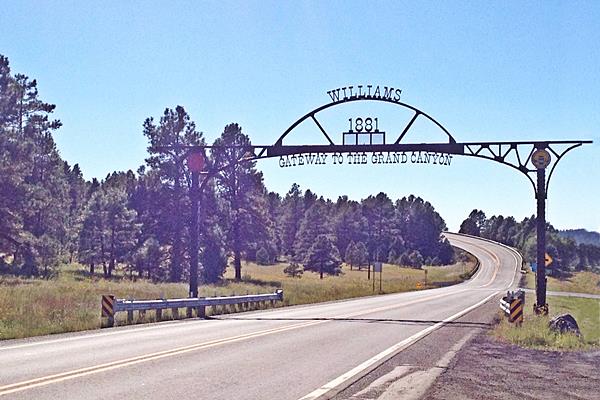
The Arch Gateway receives visitors entering Williams, the steel arch proclaims: "Williams Gateway to the Grand Canyon - 1881."

Sights and Attractions in Grand Canyon
There are many options and things to do and places to see. You can visit the South Rim and the North Rim (via US 89 and Alt.89) a journey of 213 miles (see map) to reach a point just 10 miles north of Grand Canyon Village!
We visited the Grand Canyon as part of our road trip and dedicated one day to the South Rim, we started out early from Flagstaff on a hot, sunny August morning. And stayed all day till sunset.
What to do in one day?
This is perhaps one of the best known natural attractions in the U.S. We spent a full day at Grand Canyon in July and this is what we did:
We drove in through the South Entrance along AZ-64. We bought the Annual Pass for $80 (and saved a fortune because we used it at many parks on that trip: Zion, Bryce Canyon, Yellowstone, Yosemite, Arches, Capitol Reef, Grand Teton, Sequoia-Kings Canyon).
We parked at the Grand Canyon Visitor Center Parking Lot next to Mather Point. We then walked along the Rim Trail to the Village, a 2.1 mile walk (3,4 km). Very good views of the Grand Canyon, the geology -with stones that are hundreds of millions of years old exhibited along the way. Lovely pine trees shading most of the way.
There are restrooms at the Visitor Center, Village and Market Plaza. Take plenty of drinking water with you. Wear a hat and use sunblock in summer.

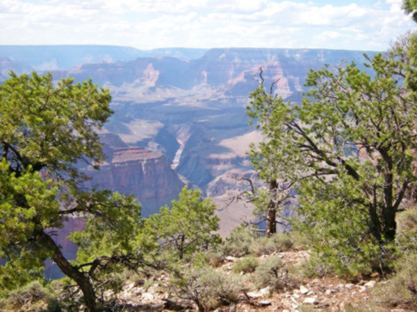
View of the Grand Canyon. Austin Whittall

View of the Grand Canyon. Austin Whittall
A free shuttle bus runs between the Visitor Center and the Village, passing through Market Plaza. There is another one, running west along Hermit Road (we took it) all the way to Hermits Rest (food, restrooms available there).
We walked around the Village and visited the main sights: Verkamp's Visitor Center, Hopi House (outside there were some natives performing traditional dances, worth seeing) and El Tovar Hotel. We then walk along the trail west to visit Lookout Studio and Kolb Studio and right there is the bus to Hermit's Rest. You can hop on and off the bus along the road. We took it to the end point and on the way back, walked a stretch of the rim from Hermits Rest to Pima Point (1 mi. - 1.6 km) where we took the shuttle bus back to our car.
It was an amazing experience: nature, views, trees, history!
Don't feed or try to pet the squirrels, they bite and may have bubonic plague, hanta virus, or rabies! Keep 15 feet from them (5 m).
Geology and origin of the Grand Canyon
The oldest rocks at the Grand Canyon are at the bottom, where the Colorado River runs, they have been overlaid by miles of rock and sediments that have eroded away and accumulated again over the course of two billion years.
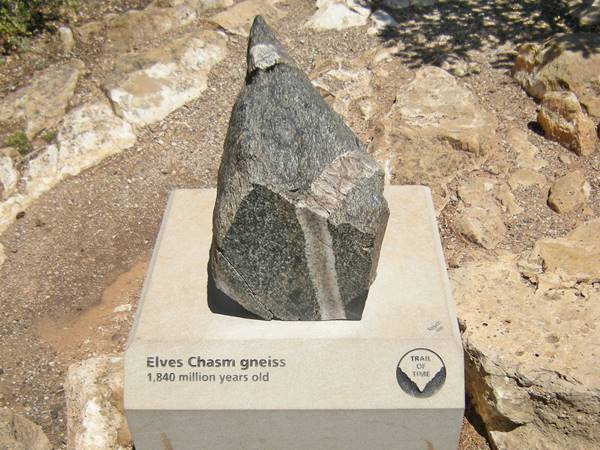
Elves Chasm gneis
Gneiss (pronounced "nice") is a kind of rock formed deep in the Earth, under great pressure and temperature. This rock has been dated by measuring the remaining radioactive elements in it, and it is incredibly old: 1.84 billion years.
The narrow section of the Grand Canyon, south of Lees Ferry bridged by US 89 at Navajo Bridge
The next series of rocks that would be 1.75 to 1.25 billion years old, are missing. This gap is known as the "Great Unconformity", when rocks were not formed or were formed but eroded away. After the gap, the Grand Canyon Supergroup limestone rocks were laid down (1.25 billion years to 730 million years old).
Sediments from an ancient ocean span the upper two-thirds of the canyon's walls, sandstones with many color (500-270 million years old) and topping it is the cream-colored Kaibab limestone 270 million years old.
Around 70 million years ago the tectonic plates moved again and the Rocky Mountains were thurst upwards and snowmelt started flowing westwards, forming the Colorado River. Around 6 million years ago, the area of the Grand Canyon was also thrust upwards as the Colorado Plateau rose and the river started cutting into it, forming the Grand Canyon.
Colorado River
One of the main rivers in the Southwests, it flows 1,450 miles (2,330 km) from its headwaters near Kremmling Colorado at 10,184 ft (3,104 m) in the Rocky Mountains to the Gulf of California.
It crosses Colorado, Utah, Arizona, Nevada and California; then Sonora and Baja in Mexico to reach the Pacific Ocean.
The Grand Canyon Railway
Listed in the National Register of Historic Places
In 1901 the Atchison, Topeka and Santa Fe Railway finished the branch line that linked the main line at Williams with Grand Canyon Village at the South Rim of the Grand Canyon.
It is a 64 mile (103 km) long line built in standard gauge of 4ft 1⁄2 in. (143.5 cm).
In 1905 the railway built the El Tovar Hotel a few feet from the Grand Canyon rim.
Take the Train to visit the Grand Canyon
The use of automobiles caused a drop in passengers and it stopped carrying them in 1968. The line closed down in 1974.
It was recovered in 1988 and reopened in 1989 using climate-controlled coaches built in the 1950s.
There are dailly "Williams Flyer services to and from the Grand Canyon plus other services (like the winter Polar Express), which use the restored Santa Fe Railway Station in downtown Williams. There is also Amtrak's Southwest Chief trains (from Los Angeles to Chicago) at Williams Junction station 3 miles east of Williams, and a motorcoach linking both stations.
>> Here you can Book your Hotel in the Grand Canyon Area.
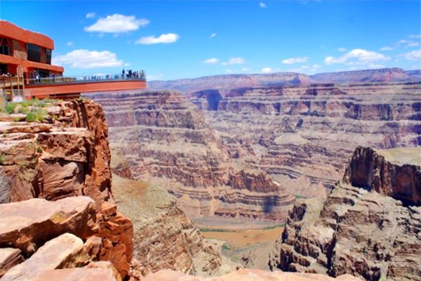
The Grand Canyon Skywalk
Opened in 2007 it is within the Hualapai Tribal land. It is a transparent horseshoe-shaped bridge that curves out and above the Grand Canyon 4,770 ft (1.450 m) above the Colorado River.
The best way to reach it is taking a tour as the roads are not in top conditions.
Read more at the Skywalk website.
Grand Canyon Skywalk

Some sponsored content
Lake Havasu City

Lake Havasu City, the lake and London Bridge. Source
The resort town of Lake Havasu City on Lake Havasu has beaches along the lake's scenic shoreline, an active nightlife and the original London bridge (you can take a Tour to visit it)
The adjacent state park is open 24 hs, and there is an entrance fee. It is located on a reservoir on the Colorado River. You can hike and enjoy the riverside.
Visit the scenic shoreline with beautiful beaches, nature trails, boat ramps, and many convenient campsites.
>> Book your Hotel in Lake Havasu City
Learn more about the outdoor sites in the Havasu State Park official website.
>> Book your Hotel in Williams AZ

Credits
Banner image: Hackberry General Store, Hackberry, Arizona by Perla Eichenblat
Jack DeVere Rittenhouse, (1946). A Guide Book to Highway 66.


