
Historic Route 66 Williams to Kingman
Background on Historic Route 66

Thumbnail of the 1935 Arizona highway map. Source
Click on thumbnail map to enlarge
Route 66 was aligned along the National Old Trails highway that followed the railroad tracks between Williams and Kingman. It was relatively level and avoided sharp grades. The map above, published by Arizona's Deparment of Transportation in 1935 shows that the highway was mostly paved (red line) by that time.
The freeway replaced the segment between Ash Fork and Kingman, and that section of Route 66 has been listed in the National Register of Historic Places.

Route 66 from Williams to Kingman
Williams, starting point of this leg
We will begin our itinerary on the western side of Williams and head west.
From Williams to Ash Fork
Rittenhouse described the road in his classic "A Guide Book to Highway 66" published in 1946 after he drove along it from Chicago to Los Angeles. Hismentions the road between and Ash Fork as being 19 miles long, "but in this distance you drop 1,700 feet down winding grades which are tricky on winter nights when the road is icy. Inquire about road conditions before starting, if driving at night". This sounded rather challenging for the average driver.
He also noted that there was a public campground 1 mile west of Williams and 5 miles further ahead, was the Pine Springs Ranch Lodge with a gas station and log cabins.
Westwards from Williams, the 1926 to 1984 alignment
It is a 2 mile stretch from the western tip of Williams and past I-40s exit 161, long the South Frontage Road. The segment ends at Mountain Spring Ranch. See a map of this segment. West of this point, the original roadbed disappears under the eastbound lanes of I-40. We marked it with a black line in our custom map of Route 66 in AZ (just west of Williams).
Go onto I-40, head west and get off at Exit 157, here you will reach a Historic Sector of US66
Rural Route 66: Pine Springs Section
Listed in the National Register of Historic Places
At Exit 157, head south along FR 108 until the Pine Springs Camp. It is in this area that the "old Route 66" reappears on the south side of I-40 and heads west following two alignments:
- The 1926 to 1932 road (via Bixler Saddle Rd), as shown in this map.
- The 1932 to 1952 road (Bill Williams Loop Rd - Fire Rd 1089). Shown in this map.
Both alignments converge at Pine Springs Camp which had cabins, lodge and gas in those days.
From Pine Springs Camp the 1926-1952 alignment heads west for one mile (see map) and again disappears under the eastbound lanes of I-40.
Ash Fork Hill
Ash Fork Hill, the abandoned sections west of Pine Springs
Though US 66 is mostly buried under I-40, in some parts it surfaces to the south of the Interstate and you can still spot the old road's remains (like ths concrete culvert in the forest on the south side of I-40 shown in the image below:
Old US66 culvert seen from I-40.


Thumbnail of 1947 and current maps at McLellan. Click on thumbnail map to enlarge
Then the road curves further towards the south and turns back sharply to what is now I-40 (you can see this "u" shaped course in the thumbnail map, click on it for full sized image).
Then it is cut by I-40 (Point where it crosses I-40), continuing to the north side of I-40 where the 1932 to 1952 segment it can still be driven; notice that it is a dirt road so drive carefully.
The 1952 - 1979 segment of Route 66 was aligned where I-40 is after this point and obliterated by the freeway.
We marked this segment with a Green line in our custom map of Route 66 in AZ (west of Pine Springs).
Ash Fork Hill western section
A difficult section was the incline from Pine Springs Ranch at 6,750 feet to Ash Fork at 5,140 feet. This incline was one of the steepest along the whole of Route 66.
The original dirt road was replaced in 1932 by a new one that was paved but, more or less followed the earlier one. As traffic increased during World War II and after, a new and less steeper alignment was built in 1950. I-40 was built on top of it.
The old road was abandoned and although most of it is closed to the public, it can be walked along; it is part of the Kaibab National Forest.
Below is a "Then and Now" view of the same spot showing the remains of the old roadway (red arrow):


Picacho Butte (Picacho is a "solitary peak" in Spanish) can be seen in the distance (left) in both images. It is a circular volcanic dome roughly 9 million years old, 7,171 ft high (2,186 m).
The modern freeway cuts through the hills and avoids the narrow winding cliff-hanging course of the old roadway.
1932 - 1952 Ash Fork section east of Exit 149
To reach this segment, leave I-40 at Exit 149, which is next to the section's western tip and head east as shown in this map.
West from Exit 149: the 1926-1979 road more or less lies under I-40. The exception is the 1965 alignment on the south side of I-40 after Exit 148. You can drive a short 0.6 mile stretch (map here) past the remains of the classic 1960s Martin's Motel and County Line Cafe. We show the alignment into Ash Fork now gone or buried by I-40 with a Violet line in our custom map of Route 66 in AZ (east of Ash Fork).
Ash Fork
Entering Ash Fork
All alignments entered Ash Fork westwards, you can follow it from I-40's Exit 146. Until 1950 it crossed the town as a two lane road (along Lewis Ave.) and from 1950 to 1979 Lewis Ave. carried the westbound traffic while Park Ave. took the eastbound flow.
Across Ash Fork
Map of the segment across Ash Fork, it was used from 1926 to 1979. At I-40s Exit 144, the old alignment merges and disappears under the westbound lanes of the Interstate.
West of Ash Fork

The 1926 to 1965 Route 66 west of Ash Fork seen from the eastbound lanes of I-40.
Click on image for Street View
The part that cannot be driven is marked with a Black line in our custom map of Route 66 in AZ (west of Ash Fork).
After the "gap", the roadbed used from 1926 to the 1950s then heads to the south side of I-40 and can be driven along a 3.2 mile segment (you can reach it from Exit 139). However its western tip is once again buried under I-40; see the map of this segment. The image shows what it looks like nowadays from the freeway.
All the US 66 alignments (1926 onwards) resurface once again at Exit 139, (our custom map shows the gap with a gray line). The highway heads away from the freeway towards the next town: Seligman as the Longest remaining segment of Route 66 in the whole of the U.S., and it ends at Topock on the Colorado River, at the California state line.
Hotels and Motels along this segment
Lodging & accommodation between Williams and Kingman, sponsored content. Find a room in neighboring on this leg of your Route 66 road trip.
Find your room in the motels in Williams (sponsored content):
>> Book your room in Williams
More Accommodation near Williams on Route 66
There are plenty of lodging options in the cities and towns along Route 66 east and west of Williams; click on the links below to find your accommodation in these towns, listed from east to west:
Eastwards
In Arizona Along Route 66
Westwards
You are so close to Las Vegas and the Grand Canyon!


>> RV campgrounds in Peach Springs
Into Seligman
The Crookton Road segment
From Exit 139 westwards begins the 1920s to 1979 stretch of Route 66. It is known as Crookton Road as it heads straight towards Crookton Hill (6.3 miles away) and skirts around its base. The railway had set up a siding here and named it Crookton after General George Crook (1830-1890), who fought in the American Civil War and the Indian Wars.
Just before it curves around the hill, a fork opens to the right which is the pre-1940s alignment. Both meet again 0.8 miles west of the hill. See a map of the older alignment, also in our custom map, marked with an orange line.
Railroad Bridge 1926-30s

The Old Route 66 Bridge east of Seligman. Click for street view
The road then curves to cross the railroad. To your right is the "old" 1930s bridge on the alignment used from 1920s until the 1930s. See image.
Sections of the original roadbed
The current roadbed was built in the 1930s and carried Route 66 until 1979, but the original 1926 highway can still be seen: Over the next few miles, the "old" pre-1930s alignment winds across the current road. We have marked it with a Pink line in our custom map of Route 66 in AZ (west of the railroad bridge).
Among the shrubs and stunted trees you can make out the cracked concrete, sun baked asphalt and even some old culverts and concrete bridges (pictured below).

Original Route 66 pre-1930s Bridge east of Seligman. Click for street view

Culvert and embankment on pre-1930s US66 east of Seligman. Click for street view
See this satellite view where the old cracked roadbed can be seen next to modern '66, we marked it with red arrows.
Seligman

Main Street in Seligman. A. Whittall
The highway reaches Seligman. The road until 1930 went along Railway Ave. and Main St., as shown in this Map.
Later it adopted the current alignment along Chino Street.
A lot of traffic went through Seligman: at the end of 1937, the Arizona Highway Department reported that the number of cars traveling on Route 66 that year with out-of-state plates numbered 514,332.
But it took some time to improve traffic congestion in the town; only in 1966 did the Highway Department widen Route 66 through Seligman.
Leaving Seligman
A 1951 roadmap of the Seligman to Kingman US 66, Truxton does not appear (it was founded that year).

Head west along Route 66 from downtown Seligman. At the western tip of town the 1926-30 alignment turned south (on the west side of the modern Chevron gas station located there by the entrance ramps to I-40) and crossed the tracks.
See this image with this original alignment (marked with red arrows); we marked the location of a culvert on this old alignment in this Satellite view. We also marked its course with Navy Blue line in our custom map of Route 66 in AZ (west of Seligman).
This original alignment curved to the southwest and then to the northeast running parallel to the tracks until it reached the depot at Chino where it crossed the tracks (at that time there was only one line, the one following modern US66, the other set of the tracks didn't exist back then.
The old road is cut by Route 66, and continues with a NW course to the right of the modern highway. The power line marks the course of the 1926-1930s alignment.
Both 1930s and the later alignment meet again 2.7 miles further west, where the power line joins the highway once again (Navy blue line ends here in our custom map). To the right you will see the edge of the mesa known as Aubrey Cliffs, a red sandstone formation.
Towards Grand Canyon Caverns
After driving 18.7 mi. west of Seligman, to your left you will see some trees and the 1946 Pica Motel (not mentioned by Rittenhouse as it was completed after his trip through the area). Street View.
The 1940s to 1979 road runs in a long straight stretch through Aubrey Valley passing by Rittenhouse's "Deer Lodge" (17 mi.), which offered "Cabins and gas." They are long gone, but there are homes nowadays at this site. Just two miles ahead is Hyde Park, to the right.
Hyde Park

Satellite view ruins of Hyde Park west of Seligman. Click for satellite view
Rittenhouse mentioned it as a Café with cabins and gasoline.
It's slogan was "Park your Hide at Hyde Park" and was the nearest lodging to the famour "Yampai - Coconino Caverns" (now the Grand Canyon Caverns). All that remains of it are the foundations and rubble as you can see in the satellite view below.
This section of Route 66, through Cedar Grove and up to the Indian Reservation was not paved until after 1935.
Grand Canyon Caverns
On the south side of the road, Hyde Park Rd. leads to Yampai Divide (a railway siding) and 1.6 miles ahead is the access to Grand Canyon Caverns Village (26.3 mi. from Seligman). Drive down it (Access Map to reach the Grand Canyon Caverns).

Onwards to Peach Springs
The road keeps on straight, crossing the Indian Reservation Boundary. And then, the old 1926-1930 road turns to the south side of the modern alignment, along what is now Indian Route 19, heading towards the railroad at Nelson (where there is a plant producing lime) and then west into Peach Springs. See this map of the 1926-30 alignment. Then it was shortened to its present course, but it was later modified.
The 1940s to 1979 US66 continues, paved, all the way into Peach Springs north of the railroad and was later realigned insome spots its original 1930s-1940s alignment can still be seen from the highway.
We marked it with a pale green line in our custom map (east of Peach Spgs.) and also with this image map of the 1930-40s alignment.

Old bridge on 1926-30s US 66. Click for street view
You can clearly see to the left (south side of the current alignment), an old bridge and the highway's original embankment close tothe Coconinio - Yavapai county line.
Peach Springs
The road descends into Peach Springs , the "Capital of the Hualpai Nation".
There is another segment of original highway on the eastern side of Peach Springs to your right, on the north side of the highway (1966 aerial photo), it has been built over when the modern High View Drive was built. (red line in our custom map).
Peach Springs to Truxton
It is 8.5 miles from Peach Springs to Truxton and all of it part of the 1940 - 1979 alignment of Route 66.
Two miles (2 mi.) west of Peach Springs the pre-1940s US 66 roadbed can be seen as it comes from the south and splits towards the north side of the current alignment and then curves back, crossing it, and passing towards the south side, running more or less parallel to it towards Truxton. This is the image with a map of this segment. We also marked it with a violet line in our custom map (between Truxton and Peach Springs).
This old alignment cannot be driven nowadays but you could walk it (be careful of trespassing private property).
Truxton
The old roadbedpasses reaches Truxton. See this map of this segment.
The Frontier Motel and Café in Truxton


1923 National Old Trails map at Valentine (detail)
Click image for larger full map
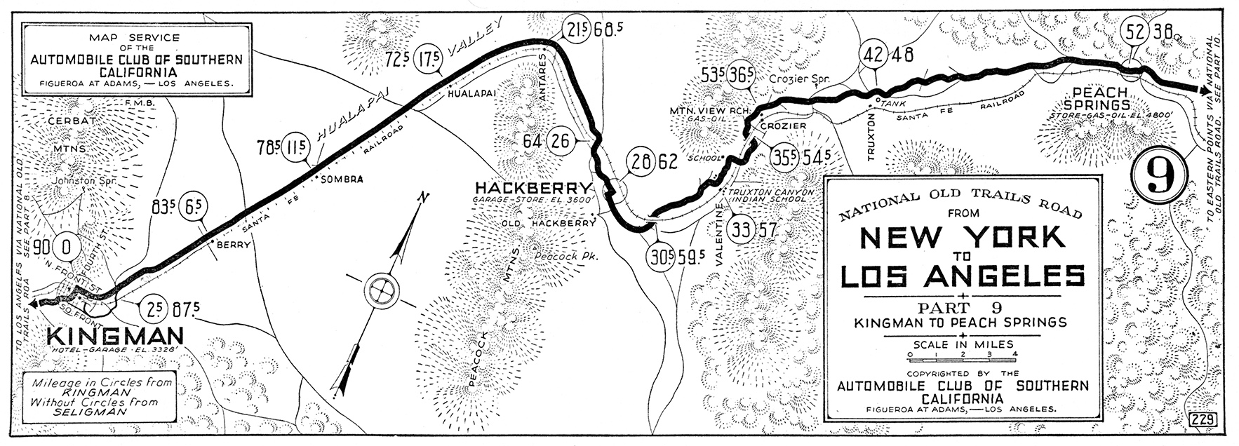
from Peach Springs to Kingman
Source
The highway heads towards the southwest and continues with a single alignment up to Crozier Canyon. Here the terrain becomes more abrupt and the highway turns towards the south.
Crozier Canyon Section
At Crozier Canyon the 1926-1937 roadbed had a different alignment to the current one. It was located further east.
We marked the first abandoned segment on the northern side of the canyon with a green line in our custom map; it is on the left side of the highway.
Ahead, by the stream is the second stretch of the old roadbed. We also marked it with a
dark green line in our custom map.
This part of the road includes the Old concrete bridge pictured below.

View of the concrete bridge on Old Route 66.
Click for St. view
After the the floods in 1937 razed the recreation area by the stream (postcard below), the roadway was moved to higher ground, to the west of the railroad.
See this image map of the alignment in Crozier.
The cabins can still be seen and are now used as storage sheds. The other buildings lie on private property, as does the old Route 66 bridge north of the cabins.
The last segment of Route 66 to be paved in Arizona was the one by the mouth of the canyon, in 1937.
A 1930s postcard showing the resort on Route 66 in Crozier Canyon

The postcard above looks south towards Valentine and Hackberry. It shows the dry stream and the bridge (front left) with the bus stop next.
Modern Route 66 passes by the point where this view was taken from.
Into Valentine
Just ahead, the old alignment ran to the east of the tracks all the way into Valentine, to its station, as shown in this Map, its length is 3 miles.
Both alignments "new and old" meet again in front of the Historic Valentine School.
Drive west from this point for 1.5 miles along the paved Route 66 and you will reach a cutting where the following "Then-and-Now" sequence of Route 66 was taken. It was published in May 1934 and captioned "a recently completed section of U.S. Highway 66 near Hackberry constructed by state force".
The images show it as it was in 1934 and as it is today. The same rock outcrop is on the right side of US 66.

US 66 in Valentine in 1934
Source

US 66 in Valentine today. Click for street. view
From Valentine to Hackberry
From the Historic School in Valentine, Route 66 runs with a southwestern course and when it reaches the old Post Office of Valentine it takes a western direction.
Old gas station, Valentine

Route 66's Courses
At Hackberry Rd., the older and newer alignments split again.
1926 - 1930 roadbed
Take a left along Hackberry Rd. (south) cross the tracks and then head right (west) following Main Rd. all the way into Hackberry. The road goes through the village and then crosses the railroad and meets Route 66 by Hackberry's General Store as shown in this map.
1937-1979 alignment
The later (1937) the road was shortened, bypassing Hackberry altogether (current alignment) with a northwestern direction, parallel to the course of the railroad which skirted the Peackock mountains until reaching the Antares siding, where it turned sharply towards Kingman with a southwestern course.
Hackberry
Don't miss the General Store in Hackberry pictured below:
Old pumps and Hackberry's General Store

From Hackberry to Antares and onwards to Kingman
From the General Store head to the northwest along Route 66, the village of Antares is only 6 mi. away.
In this section, the road adopted the course of the railroad which skirted the Peackock mountains until reaching the Antares siding.
The 1926 - 1930s alignment west of Hackberry
The National Olt Trails (N.O.T.) highway and the first alignment of US 66 prior to being realigned in the 1930s on the north side of the railroad, ran on the south side of the tracks west of Hackberry, as shown in this map, meeting the later (1930s-1979) alignment 2 miles northwest of the town.
From here, both alignments coincided as they ran straight towards Antares, curving sharply (90°) to the southwest, towards Kingman.
From Antares it ran with a straight southwesterly course along the flat Hualapai Valley, with the Peacock mountains to the left.
The 1946 Route 66 guidbook written by Rittenhouse mentions Hackberry but does not mention any other landmarks until reaching Kingman. He only states that the road left Crozier Canyon shortly after leaving Hackberry and ran "amazingly straight" along a "great plain" all the way into Kingman.
Information in the old maps
1910s National Old Trails (N.O.T) map of the region shows Hackberry at the foot of Peacock Peak and to the northwest, the station of Antares; but it has no references to garages or stores there.
There were four other railroad sidings between Antares and Kingman (but no stores or gas): Hualapai, Sombra, Berry and Louise.
The Arizona DOT map of 1935 marks Hackberry and the paved road runs all the way to Topock, passing through "Hualapai", 12.4 miles west of Hackberry. No mention of Antares.
Into Kingman
From Antares, the road runs straight (map Antares-Kingman), through the community Valle Vista (which did not exist during the "classic" days of Route 66) and past the Hualapai and Berry sidings. At Kingman Airport, the westbound lanes of the modern four lane highway are the 1930s-1979 Route 66 roadbed; the eastbound ones were added after 1979.
The road then crosses I-40 entering Kingman along East Andy Devine Rd. There is only one section of the original US66 that deviates from this alignment:
Old Alignment on Chadwick Drive
After the freeway, as the highway curves to the south, there is a section along what is now Chadwick Dr., that was the alignment of Route 66 until the 1940s when a cut through the hill straightened the alignment. (Map of this segment).
Ahead, the highway reaches Downtown Kingman, endpoint of this leg of your road trip.
Classic Trovatore Motel in Kingman

Continue your journey
Our itinerary from Williams to Kingman - Arizona ends here, you can carry on westwards into California, see below:
Next Section
Route 66 alignments from Kingman to Topock AZ
Previous Section
Route 66 alignments from Winona to Williams AZ
Credits

Some sponsored content
> > Book your Hotel in Topock.
Credits
Banner image: Hackberry General Store, Hackberry, Arizona by Perla Eichenblat.
Jack DeVere Rittenhouse, (1946). A Guide Book to Highway 66
Route 66 Maps. Arizona D.O.T.