The Petrified Forest and Route 66
Index to this page
About Petrified Forest, Arizona
Facts, Trivia and useful information
Petrified Forest is located on the original Route 66. In fact, it has a stop with some Route 66 mementos. You can reach it from either of these two towns, both on Route 66 and I-40:
- Navajo in the east
- Holbrook in the west
The weather in Petrified Forest NP

Location of Petrified Forest, Route 66
Petrified Forest has a dry semi-arid climate with hot summers and cold winters. The day-to-night temperature swing is considerable throughout the year due to the low relative humidity; this means that Summer nights are pleasant and cool, but winter nights are quite cold.
The average high temperature during summer (July) is around 95.4°F (35.2°C) and the average summer low is approx. 598°F (15.4°C).
The winter (January) average high is 50.6°F (10.3°C); and the average low is 20.9°F which is below freezing (-6.2°C).
The arid area does not receive much rainfall, only 9.2 inches per year (234 mm). Half of it falls during the Summer Monsoon period from July to October (4.9 in. - 125 mm). There are some 49 days with precipitation every year.
Snowfall is light with about 6.3 in. per year (16 cm), which falls between October and April.
Tornado risk
There is almost zero tornado risk in Petrified Forest: Navajo County has no Tornado watches. The area west of the Rocky Mountains has virtually no tornado events at all.
Tornado Risk: read more about Tornado Risk along Route66.
Route 66 to the Petrified Forest map
You can reach Petrified Forest along Interstate 40 and Old Route 66 in Arizona.
Route 66's Alignment near Petrified Forest
With maps and full information of the highway:
- Winslow to Winona (next)
- Lupton to Winslow (The Park's segment)
- Albuquerque to Lupton (previous)
Route 66 in the Petrified Forest National Park
For those who'd rather drive along the freeway, go along I-40 from Sanders to exit 311, and enter the National Park (you will have to pay a fee to do so).
Once in the park you can visit the remains of two classic Route 66 Trading posts on the old (unpaved alignment of Route 66). Below we describe this short tour.
Trading Posts
Painted Desert Trading Post
Landmark
There were actually two Trading Posts with a very similar name on Route 66 east of Holbrook in the Petrified Forest area: the Painted Desert Point Trading Post (closer to Holbrook) and the Painted Desert Trading Post (further east), we will start with the latter.
Painted Desert Trading Post
It is further east (see this map with directions), head north from Exit 311 enter the park, pay the fee and check at the Visitor Center for additional information.
Just ahead, take a left along the dirt road eastwards, drive east for 6.3 miles along Pinta Rd. Cross the bridge over Dead Wash (named so because a prospector named Lewis was found dead there by his neighbor, Jackson, in 1897). Just ahead is the Post.
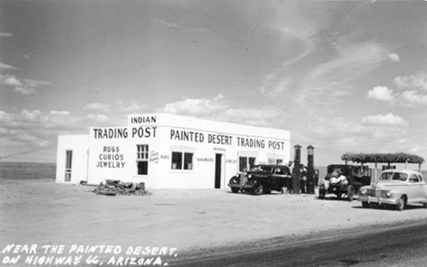
The Painted Desert Trading post offered rugs, curios, jewelry, and also sandwiches and cold beverages. It had two gas pumps in the front (no canopy), and a simple white building with a flat top and the three windows that faced forward with a single entry door.
It was built by Dotch Windsor in 1942, who ran it with his first wife Joy Nevin until they divorced in 1956. It was the dawn of the Interstate period and Dotch closed the post.
Painted Desert Trading Post in the 1930s. Petrified Forest National Park near Holbrook, AZ. Route 66
Holbrook, AZ, Source
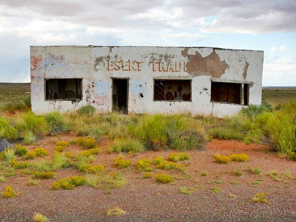
Nowadays, eighty years later, the passing of time has caused, ruin and decay. As you can see below, the dorway is empty and the windows gone. The words Desert Trading Post can still be made out on the front of the former store:
Painted Desert Trading Post today Petrified Forest National Park near Holbrook, AZ. Route 66
Holbrook, AZ, Image Credits
A Short tour in the National Park
The views on this side of the park are amazing, the Painted Desert deserves its name.
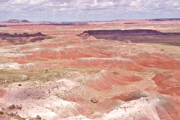
Head back to your starting point on the paved road. Here is a short gap in US 66 (The original Route 66 continues west but cannot be driven here) you can continue your drive in the park, visiting Tiponi Point, Painted Desert Rim and visit the historic Painted Desert Inn and Kachina Point. All of them are located on Petrified Forest Road, which describes a wide arch to the north, and then heads west and south again.
Stop at the scenic points of Pintado Point and Lacey Point. Then you will reach the Route 66 Monument.
Route 66 Marker
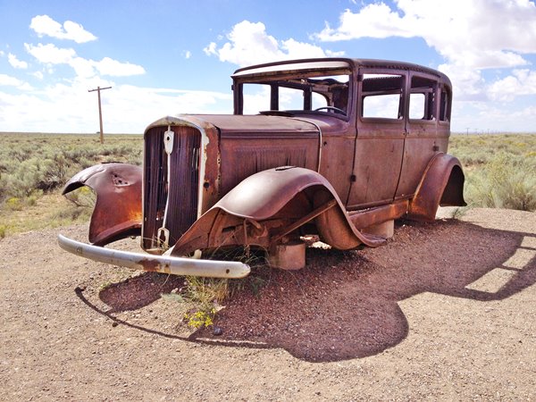
See where it is, in this map, the point marks where Route 66, coming from the trading post in the east, crosses Petrified Forest Rd. and heads west into the desert. The roadbed is not visible at ground level, but can be seen in satellite images. A line of telephone poles marks the alignment of the original Route 66 (you can see them in the photograph).
The marker has a concrete bench with a Route 66 shield, and a chrome vintage car bumper set in it. It belonged to a 1957 Cadillac Fleetwood. It is a front Dagmar Bumper (the word Dagmar came from the splendid figure -and bosom- of Virginia Ruth Egnor's 1950s TV character "Dagmar").
Next to it are the remains of a rusty 1932 Studebaker and a sign with information titled "Highway of Dreams".
At this point you have the choice of visiting the rest of Petrified Forest Nat. Park, which stretches north to south between I-40 and US. Hwy 180.
Or you can also retrace your steps to I-40 and continue west exploring the alignment of Route 66. We suggest doing both! The park is amazing.
Route 66 heading West from the Park
Return to Exit 311 on I-40 and head west along the freeway. The original US 66 alignment coming from the Route 66 Marker is now buried under the bushes, it crosses the freeway 2 miles west of Exit 311 (see map).
The freeway cuts the old alignment at this point; the original Route 66 continues on the south side of I-40. This alignment can be driven. To reach it if you want to drive along it, leave I-40 at Exit 303.
This is map of the driveable US 66 alignment from Petrified Forest to Little Lithodendron Wash, it is a 8.1 mile-long segment.
At the exit, turn left, eastbound to the "other" Painted DesertTrading post. It is a 3.8 mile drive.
Painted Desert Point Trading Post

1940s postcard of the
Painted Desert Point Trading Post
nps.gov
It was located 21 miles east of Holbrook. You can reach it (map with directions) from Exit 303 on I-40 head to the south side and drive east for 3.8 mi. It is on the north side of the Old Route 66.
Built in 1946, it sold Shell gasoline. Only the foundations of the rectangular building and the concrete base of the gas pumps remain. At one time it was rumored that it had illegal slot machines. It was run by Harry Charles Osborne, who in 1952, aged 78 was forced to kill his deranged son at the trading post.
Head back to Exit 310, and head one-half mile east along US 66 right to head west along old US 66 to reach the bridge:
Little Lithodendron Wash Bridge
Route 66Holbrook, AZ.
Listed in the National Register of Historic Places
A wooden truss bridge built in the 1932 on US Highway 66
This wooden bridge is 243 ft. long and 23 ft. wide, its longest span is 18.7 ft. long. It crosses the Little Lithodendron Wash, also known as Carrizo or Little Carrizo Wash -Carrizo is Spanish for "rush".
The word Lithodendron combines the Greek words "Lithos" (stone) and "Dendros" (tree), "stone tree" after the neighboring Petrified Forest National Park.
The wash has several branches that Route 66 had to cross. Two bridges were erected in this spot, and only one survives. It is a timber tressle bridge built 1932 and rehabilitated in 1986 it can still be driven across.
It is a "tressle" bridge because the short timber spans are supported by a rigid frame or "tressle". This is a Street View of the historic bridge.
Continue west along Route 66 for 2.5 miles till you reach Exit 300. Here I-40 curves so the old alignment of Route 66 lies on the north side of the freeway, and you can see the old road from I-40.
From this point west, the 1930s alingment lies under the freeway all the way to Holbrook, where at Exit 289 it resurfaces and you can drive along it into the town.
1926 Alignment
The 1930s alignment is beneath the freeway, but the first US 66 aligment survives as Pima St. and Horse Head Crossing. This Map shows its course. Since it starts and ends at dead-ends, you must access this segment from Exit 294.
While at the exit, visit another Route 66 Classic, from the 1960s, a former Stuckey's.
Sun Valley Stuckey's
7699 Sun Valley Rd, At exit 294
On the southwestern side of the exit is the former Sun Valley Station. Located only 8 miles east of Holbrook, it once had a Texaco gas station and a Stuckey's convenience store chain. Its slogan was "Relax, refresh, refuel!".
The building was "8 miles east of Holbrook, Ariz. Hwy 66 & Interstate 40", and it is still standing, with its typical "A" shaped roof. Now it is a knifeshop.

Vintage photo of Stuckey's
Credits

Nowadays Credits
Route 66 Alignment near Petrified Forest NP
With maps and full information of the old roadway.
- Winslow to Winona (next)
- Lupton to Winslow (The Park is on this segment)
- Albuquerque to Lupton (previous)
Petrified Forest National Park
It is the only National Park in the U.S. to include and protect a section of Route66. Its badlands of multi-colored stones with bands of red, violet, green, ochre and white sediments from the Triassic period 200-million years ago are worth seeing. And then is the petrified wood, the fossils and historical sites...
What to see and do?

Agate bridge, 110 ft (34 m long) fossil trunk with a concrete beam supporting it since 1917. A. Whittall.
Short 2 to 3 hour visit
At least Walk the Painted Desert Rim Trail to Kachina Point, Drive Blue Mesa Road and Stop at Rainbow Forest Museum to see the stone tree trunks strewn on the ground.
- Stop at the Painted Desert Visitor Center
- Drive the 28 miles of road through the park: to the south, visit the Rainbow Forest Museum and watch the park film; walk Giant Logs and Crystal Forest trails; drive the Blue Mesa Road. To the north: Visit the Painted Desert Visitor Center and watch the park film
- Drive the circuit and stop at the overlooks in the Painted Desert, include a stop at the Painted Desert Inn National Historic Landmark.
Half a Day visit

Ruins of the Puerco Pueblo site. Don't miss the rock art here! A. Whittall.
Add the following:
- Drive through the entire park.
- Stop at Painted Desert Inn Museum (in the Historic Landmark).
- Walk the trails at Painted Desert Rim and Crystal Forest.
- Stop at the Route 66, Newspaper Rock, Agate Bridge, and Jasper Forest overlooks.
- Visit Puerco Pueblo, walk the Puerco Pueblo Trail.
- Hike the Blue Mesa and ⁄or Agate House Trails.
- Walk the Giant Logs Trail (pick up a trail guide at Rainbow Forest Museum)
One or more days
Do the above and add:
- Choose an Off the Beaten Path hike into the Wilderness Area
There is no overnight lodging in the park, camping in the park is limited to backpacking in the wilderness area and permits are required.
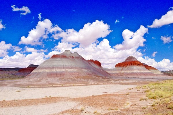
The Petrified Trees
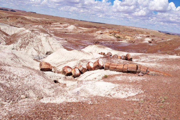
200 million years ago, during the Late Triassic Epoch this area was a lush rainforest with ferns and coniferous treees 10 ft. in diameter and 180 ft. tall. As they died or fell they were buried by sediments or covered with volcanic ash (known as the Chinle Formaiton) that preserved them before they decomposed. Ground water later dissolved silica in the volcanic ash and saturated the logs and crystallized, replacing what was once living tissue with quartz. This preserves the life-like appearance of the wood.
Iron oxides give the petrified wood its red, organge and ochre hues.
60 million years ago, the uplift of the Colorado Plateau led to the erosion of the younger rock that overlay the Chinle Formation, and this uncovered the logs and fossil plants.
The park is one of the few in the world to have flora from the LateTriassic: cycads, ferns, ginkgoes, lycopods and more.
More details: Official Petrified Forest NP Website.
Painted Desert Inn
Petrified Forest N. P.Holbrook, AZ.
Listed in the National Register of Historic Places
A classic National Park lodge built in 1920 and restored to its original 1949 appearance. Now a museum.
Built in 1920 by Herbert David Lore as a lodge, it was acquired by the National Park Service in 1935. It was originaly built in petrified wood, but it was soon renovated in a Pueblo Revival Style after it was purchased.
It has ponderosa Pine logs protruding from the adobe and stone walls, earth-toned stucco and flat roofs. It was renovated by Mary Jane Colter in 1947 and closed in 1963 when a new visitor center replaced it. It was saved from demolition in 1976 and was designated a National Historic Landmark in 1987.
It was completely restored to the way it looked back in 1949 and reopened in 2006. It is no longer an inn, but a museum, don't miss the restored murals by Hopi artist Fred Kabotie or the mountain lion petroglyph on exhibition there.
Where to Stay: Hotels close to Petrified Forest
There is lodging on Route 66 in Holbrook, right beside the parkl
>> Book your Hotel in Holbrook
More Accommodation near the Park on Route 66
There are plenty of lodging options in the cities and towns along Route 66 east and west of Petrified Forest National Park; click on the links below to find your accommodation in these towns, listed from east to west:
Eastwards
In Arizona Along Route 66
Westwards
You are so close to Las Vegas and the Grand Canyon!
>> There are RV campgrounds in Holbrook

Some sponsored content
Lake Havasu City

Lake Havasu City, the lake and London Bridge. Source
The resort town of Lake Havasu City on Lake Havasu has beaches along the lake's scenic shoreline, an active nightlife and the original London bridge (you can take a Tour to visit it)
The adjacent state park is open 24 hs, and there is an entrance fee. It is located on a reservoir on the Colorado River. You can hike and enjoy the riverside.
Visit the scenic shoreline with beautiful beaches, nature trails, boat ramps, and many convenient campsites.
>> Book your Hotel in Lake Havasu City
Learn more about the outdoor sites in the Havasu State Park official website.
>> Book your Hotel in Holbrook AZ

Credits
Banner image: Hackberry General Store, Hackberry, Arizona by Perla Eichenblat
Jack DeVere Rittenhouse, (1946). A Guide Book to Highway 66.


