Route 66 Winslow to Winona Arizona
Sponsored content

TheRoute-66.com is reader-supported. When you buy through links on our site, we may earn an affiliate commission at no additional cost to you.
Index to this page
- Winslow
- Leupp Corner
- Meteor City
- Barringer Crater
- Two Guns
- Twin Arrows and Toonerville
- Winona
- Nature and outdoors
- Hotels
The Alignment of Old Route 66 from Winslow to Winona Arizona
This segment starts in Winslow. The alignments across the town have changed over the course of the years. We describe them below.
National Old Trails

Thumbnail of the 1910s N.O.T. west of Winslow. Credits
Click on thumbnail map to enlarge
The map (Click on the thumbnail map to enlarge it) shows the original Autotrail that linked Winslow with Flagstaff. This was part of the National Old Trails (N.O.T.) highway, and it didn't follow the railroad, instead it ran straight west to the meteor crater at Barringer, and then north to where Two Guns is now located, where it crossed the Canyon Diablo, then it headed west to Winona and onwards into Flagstaff along a course more or less located where US 66 and later I-40 would run.
In 1926, Route 66 was aligned down the N.O.T and a growing flow of motorists drove down the new unpaved highway. Later it was moved north from Winslow to Two Guns, along its present course.
Route 66 in Winslow
The original Route 66 from 1926 to 1951
This map shows the National Old Trails and Route 66 1926 to 1951 alignment across Winslow. East and westbound traffic ran along 2nd Street. The alignment is cut at both its eastern and western tips by the freeway, you can see the two missing segments there, marked with a yellow line in our custom map with the eliminated segments of Route 66.
From 1951 to 1979
In 1951 the traffic was split along two streets: the eastbound traffic ran along 2nd St. and the westbound traffic along 3rd St. (map with WB lanes).
After W. Fleming St., both east and westbound lanes ran along a divided boulevard as shown in this map and after what is now Arcadia Trailer Park, it ran where the freeway's Eastbound lanes are now located, see purple line in our custom map.
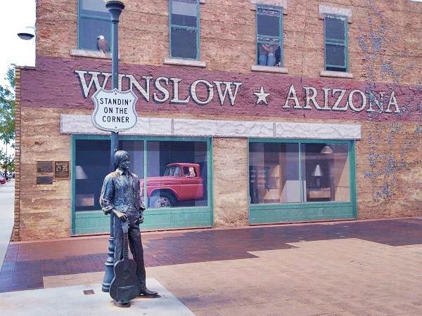
The statue at the famous "Corner" in Winslow Arizona. Route 66
Westwards from Winona to Leupp Corner
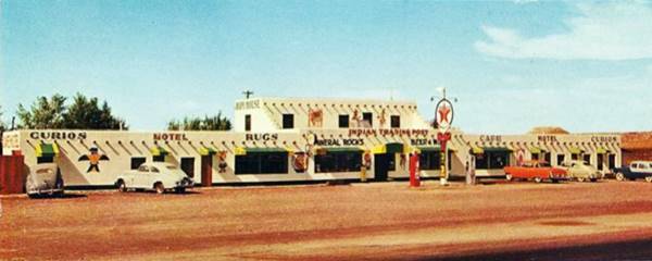
The original road lies buried by the eastbound lanes of I-40. So drive along the freeway to reach Leupp Corner. Leupp Corner is located at the spot where AZ-99 angles off towards the Northwest, leaving I-40 behind just west of Exit 45, at one time there was a trading post, cafe, motel, Texaco station and trailer park here. It was torn down when the westbound lanes were added to Route 66. Below is a vintage view of the place:
A now lost memory on Route 66: Hopi House Trading Post c.1950s
Head westwards towards your next stop.

Alignment into Meteor City AZ
1926 - 1937 US66
From Leupp Corner in the east, the original US66 highway ran west along the current eastbound lanes of I-40, then when it reached what is now Exit 239 where Meteor City is located it split from towards the Northwest along Red Gap Ranch Road.
Meteor City

Largest Dreamcatcher. Credits

Tepee, Meteor City. Credits
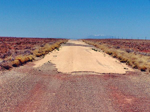
West from Meteor City the segment measures 2.5 miles, in a wide curve that returned southwards to cross the railroad (Red Gap Ranch Rd.) Nowadays it has a dead end on the east side of the railroad tracks where they meet the Freeway as you can see in the image below. This alignment is marked with a blue line in the map further down.
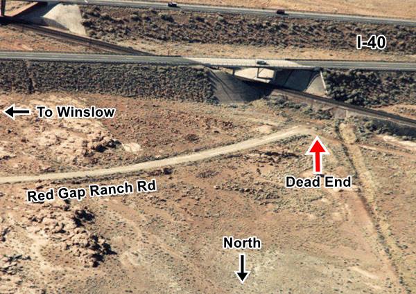
The original roadway crossed the tracks there, and headed towards what is now the south of I-40; the road then arches in a wide curve further south
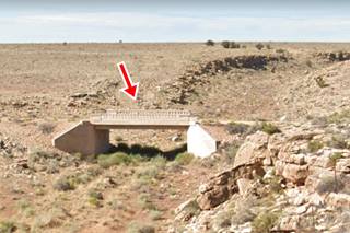
and then back again towards where I-40 is now located (black arch in the map above). It can't be driven but you can see this alignment in this map. There is concrete bridge at the western tip of this roadway -pictured above.
The original roadway curves across the freeway through the Westbound Rest Area on its north side.
You can see both gaps in the alignment (where it is cut by the freeway) in our custom map (yellow lines) with the missing segments along US66 in Eastern Arizona.
The following map shows this alignment at the rest area, click on it to see a full size map:
Click on map to enlarge
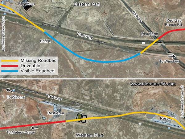
Meteor City on the Later 1940s - 1969 alignment
The road took another course after it was paved in 1935, it ran along what are now the Eastbound lanes of the freeway are located, and then after the tracks, it followed the older alignment as shown in the map above. Only after 1969 was it aligned where the freeway is.
Barringer Crater Route 66
From the rest area just east of the access road into Barringer Crater there are two alignments:
- The late 1940s alignment is now covered by the roadbed of I-40 between the Westbound Rest Area and Two Guns
- The original 1926 to 1940s alignment that can still be driven. We describe it below.
The 1926-40s alignment at Barringer Crater
Leave I-40 at Exit 233 and drive south for 0.4 mi. to the crossing of Meteor Crater Rd. and Route 66 by the RV campground. Don't miss the dome here, of the old trading post. This was the location of some scenes of the 1984 movie Starman, starring Jeff Bridges.
The Meteor Crater dome by old Route 66
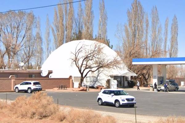
Here you have several options:
- Go East: Take a left and drive all the way to the end of the segment, which is beside the of the Eastbound Rest Area of I-40. Actually the old road is now interrupted by the rest area and I-40, as it came from the north side of I-40 (now the Westbound Rest Area). This is a 1.6 mile long segment. This is its Map. You can see it marked in red in the image further up. It passes by the ruins of the old Meteor Crater Observatory pictured below.
- Go West: Take a right and drive straight to the next Exit of I-40 (Exit 230) at Two Guns 5.4 miles away.
This is the Map from Meteor Crater Rd. to Two Guns
The street view of the ruins of the Meteor Crater Observatory nowadays:
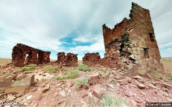
Click image for Street View
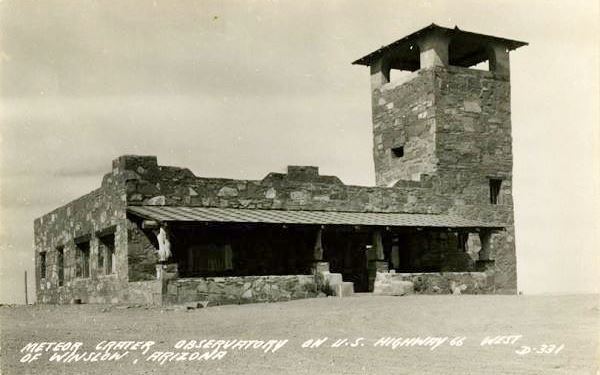
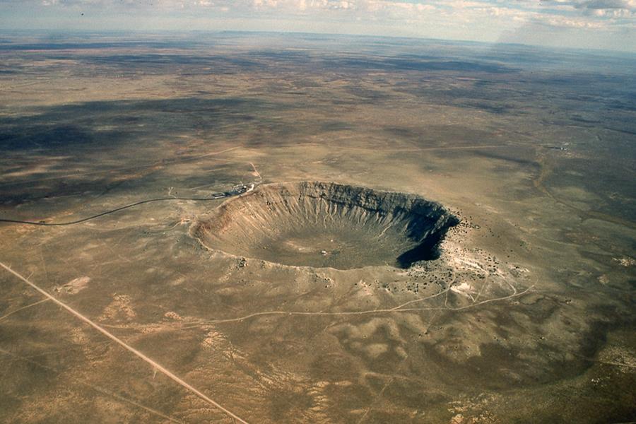
You can also visit the famous meteor crater before continuing your road trip, it is pictured below:
Barringer Crater seen from the air.
West of Barringer Crater
Two Guns
Reach Two Guns along the 1926-1940s US66 from Barringer Crater as shown in this Map. Later alignments are overlaid by the freeway.
There were several alignments at Two Guns; you can see them in our custom map with the missing segments of Route 66 in eastern Arizona. This map's color coding is the following:
- Black line marks the extant section from Barringer Crater access road to Two Guns. This carried US66 from 1926 until the 1940s, when it was moved to an alignment now overlaid by the freeway.
- Gray line west of Two Guns is a dirt section (crosses the canyon along the historic 1915 Route 66 Canyon Diablo Bridge and meets the later alignment further west. It carried the N.O.T. and Route 66 until it was realigned in the 1930s.
- Blue line is the 1930s to 1938 alignment out of Two Guns. It was replaced by a new roadbed that ran where I-40 is now located
Map showing Two Guns and its landmarks
Landmarks and US66 in Two Guns, AZ. Click on map to enlarge
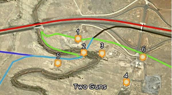
Click on Map to Enlarge
Key to the map
(1)Two Guns 2ndZoo and 1940s Texaco ruins, (2) Two Guns Trading Post Ruins next to Historic Bridge
, (3) Apache Death Cave, (4) Old KOA Campground,
(5) First Texaco and Zoo, and (6) 1970s Shell.
The colors mark the Route 66 alignments: in green the N.O.T. highway, in black the 1926 to 1940s US 66, light blue is the N.O.T. to in the 1930s US 66, blue shows the 1930s to 1938 alignment and the red line is the 1940s to 1979 US 66.
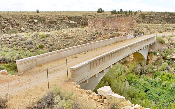
It is now on the abandoned grade of U.S. 66, which was replaced in 1938 by a new paved alignment built just to the north of Two Guns (and is now buried under I-40's roadbed).
West of Two Guns (Buffalo Road)
West of Two Guns the 1915 -1930 roadbed of Route 66 can be seen, but it is no longer a road that can be driven Gray line in our custom map. The later 1930s alignment lies under I-40. However, at I-40's Exit 225, you can head to the south side of the freeway and drive along a short section of the original 1915 - 1930 N.O.T. and Route 66. Now it is known as Buffalo Range Rd. See this Map of the segment and the missing roadwaymarked with a fucsia line in our custom map and in our image map where it is marked with arrow.
The road west of this exit is once again buried beneath I-40 until you approach Toonerville where modern Toonerville Rd. was linked to the alignment of Route 66 by a now missing segment (see it in our custom map).
Twin Arrows and Toonerville
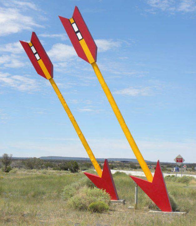
Route 66's 1926 -1937 alignment through Toonerville and Twin Arrows
The 1926 alignment of Route 66 reached Toonerville - Twin Arrows along what is now the South Service Road of I-40. As mentioned further up, it is now truncated in its eastern tip (Map of this segment).
To drive the old (1926 - 1960) Route 66 alignment in Toonerville and Twin Arrows (a 2.2 mile segment) see this Toonerville - Twin Arrows US 66 map.
Below is a photograph showing Toonerville post (upper red arrow) and the original US 66 roadbed (lower red arrow). Bushes and weeds grow through the cracks in the paving. Trees line it to the left and a fence to the right.
The original Route 66 at Toonerville
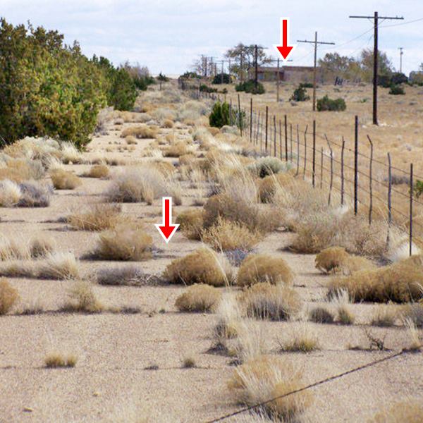
This missing segment is shown in our Toonerville Route 66 map, the red arrows mark the original alignment, also shown with a green line in our custom map.
US 66 followed the National Old Trails highway, and headed west (now partly hiden by the earthworks on the south side at Exit 219), it reappears on the north side of I-40 and runs straight until reaching the Canyon Padre, where it sharply curves south, crossed the Canyon via the historic concrete bridge, and then curved towards the west again, passing to the south and then again to the north of I-40. It then continued west along what is now AZ -394, towards Winona. Map with directions with the bridge; see also the second green line marking this alignment in our custom map.
This alignment is shown in the map below, as follows, in Black the roadbed that cannot be driven, Pale Blue: Driveable 1926 to 1960 Route 66 alignment east of Toonerville, and Blue: The 1926 to 1952 alignment of Route 66 west of Canyon Padre and all the way into Winona (Map of the alignment).
Map showing Route 66 alignment through Twin Arrows (Toonerville)
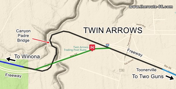
Click on Map to Enlarge
1937 realignment
In 1937, a new bridge was built to replace the dangerous 1914 one further north. It was built where the eastbound lane of I-40 is now located, leaving the old bridge and its dangerous curved access abandoned.
The eastern 1926 alignment was linked to the bridge with a new roadbed from what is now Exit 219, passing by the current Twin Arrows Trading post and meeting the 1926 alignment on the western side of Canyon Padre, on what is now AZ-394.
This is shown in Green on the map above and in purple in our custom map.
1947-52 realignment
This original roadbed remained in use until 1947 to 1952, when a new alignment (now buried under I-40) was built west of the Canyon Padre all the way to Winona from what is now Exit 219. The road east of the Canyon was moved in 1960 to an alignment that is now located beneath I-40s roadbed, and the 1937 -1960 road in front of Twin Arrows and Toonerville was abandoned. This alignment remained in use until 1979 when I-40 replaced US 66.
To drive the old (1926 - 1960) Route 66 alignment in Toonerville and Twin Arrows (a 2.2 mile segment) see this Toonerville - Twin Arrows US 66 map.
Final leg: Route 66 in Winona
The highway leaves Twin Arrows and heads towards Winona.
This is the Map of the 1926-52 alignment.
Winona Trading Post on US 66 in its heyday. A photo from 1946.
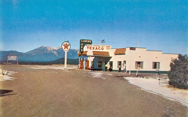
Credits
After 1952, US 66 changed its alignment and is now by I-40 all the way from Canyon Padre at Twin Arrows, to Winona.
The 1926 to 1947 road that took a more northern course became what is now AZ-394.
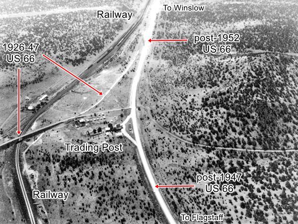
Below is a Then-and-Now sequence of images looking east from Winona. The upper image taken in 1966, shows the 1926-1947 alignment into Winona from Flagstaff (bottom left), the post-1947 Route 66 (bottom) and the post 1952 alignment (top) now forming the westbound lanes of I-40.
1966 photo of Winona from the air, looking east.
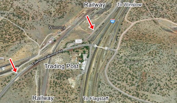
Below is the same view nowadays, I-40 was built and its two lanes running east now cross Winona. The red arrows mark the 1926 alignment.
2021 photo of Winona from the air.
Continue your journey
Our itinerary from Winslow to Winona Arizona ends here, you can continue your Road Trip along Route 66 westwards into Flagstaff and Williams AZ, see below:
Next Section
Route 66 alignments from Winona to Williams AZ
Previous Section
Route 66 alignments from Lupton to Winslow AZ
Accommodation: Hotels along this leg of your trip
Find your room in the motels nearby in Winslow or Flagstaff:
>> Book your Hotel in Winslow
More Lodging Near Winslow along Route 66
There are plenty of lodging options in the cities and towns along Route 66 east and west of Winslow; click on the links below to find your accommodation in these towns, listed from east to west:
Eastwards
In Arizona Along Route 66
Westwards
You are so close to Las Vegas and the Grand Canyon!
There is a RV campground in Barringer Crater
Nature and Outdoors Close to this Section
Petrified Forest
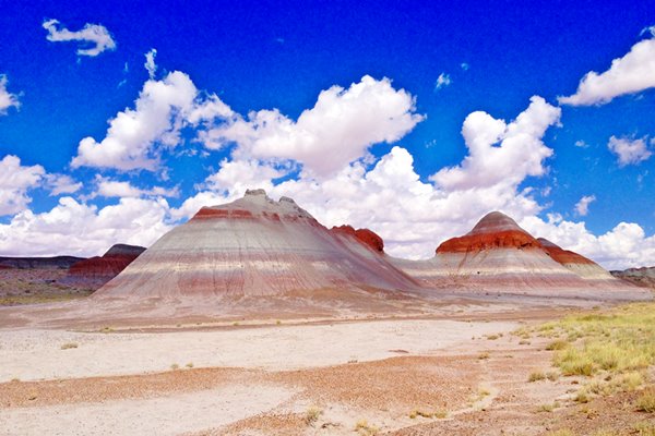
Tip: consider visiting the Petrified Forest National Park (near Holbrook) on your Road Trip.
Only National Park on Route 66
If you visit the Grand Canyon
>> Learn more about the Grand Canyon National Park and US66
Some tours and sightseeing
Sponsored content
>> Book your Hotel in Winslow


Credits
Banner image: Hackberry General Store, Hackberry, Arizona by Perla Eichenblat


