Route 66 in Navajo AZ
Index to this page
About Navajo, Arizona
Facts, Trivia and useful information
Elevation 5,676 ft (1.754 m); population n⁄a.
Time zone: Mountain (MST): UTC minus 7 hours. Summer (DST) no DST⁄ PDT (UTC-7).
Navajo is a unincorporated community in Apache County in the Navajo Nation, on Route 66 in the eastern part of Arizona, on Route 66.
History
Human beings have been living in Arizona for the last ten thousand years. In more recent times (from 700 to 1150 AD), the Ancestral Puebloans, or Anasazi made the Colorado Plateau their home. They lived in the area comprised by the Little Colorado River and the Rio Puerco to the south, the Rio Grande to the east, the colorado River to the east and southern Utah and Colorado to the north. They were farmers.
But drought and bellicose migrants from the north pushed them to the southeast, into New Mexico, where they became the Pueblo people ca. 1300 AD. Their land was occupied by the Navajo (who called themselves Diné - or "People"), hunter gatherers who later learned farming from the Pueblo people.
The Navajo, like the Apache, were of a Canadian origin, they were Athabaskan who migrated to the southwestern USA.
The Spanish under Francisco Vazques de Coronado reached neighboring Zuñ Pueblo in 1539 and sent a group commanded by García López de Cárdenas westwards. They passed by the spot where Navajo is now located and with the help of Hopi guides, reached the Grand Canyon and became first Europeans to see the Grand Canyon and the Colorado River.
The Spanish returned in 1597, occupied New Mexico and subdued the Pueblo people, but the Navajo kept them out of their territory. For years they raided the Spanish settlements. The invaders named them "Apachu de Nabajo" (Apache of Nabajo), which later became simply, "Navajo".
Mexico "inherited" Arizona after its independence from Spain in 1821 and lost it to the US after the Mexican American War (1846-48). The American Army sent expeditions to reconnoiter the area in the 1850s.
Fort Defiance was established in Arizona in 1851 by Col. Edwin V. Sumner and was the base used to subdue the Navajo.
Navajo Springs
The springs that give Navajo its name were known to natives and used by the different expeditions that explored the area in the 1850s
Lieutenant Amiel Weeks Whipple's 1853 expedition that surveyed the 35th parallel from Fort Smith, Arkansas to Los Angeles, California, along the 35th parallel north. Described the spot as follows: "Navajo spring, a fine pool of water which breaks out at the surface of a valley".
The expedition led by Lt. Edward Fitzgerald "Ned" Beale (1822 - 1893) to survey and build a wagon road from New Mexico to California, camped here in September 1857. His party used camels, imported from Tunis as pack animals. Though hardier than mules, the camels scared both horses and mules so the Army decided not to use them any more.
The outbreak of the American Civil war led to a retreat into New Mexico, to Fort Wingate near what is now Grants (on Route 66). The campaign against the Navajo continued from there. Also, at that time, as part of the war against the Confederacy, the Union government decided to split New Mexico and create a new territory: Arizona.
Arizona Territory
The U.S. House of Representatives passed a bill to create the United States Arizona Territory in March 1862. It defined a north-south border with New Mexico along the 107th meridian. This cut off the Confederates' access to California. The Senate passed the bill in Feb. 1863 and it was signed into law by President Abraham Lincoln on February 24, 1863.
Navajo Springs was the location where, on December 29. 1863, the federal officials formally inaugurated the government in the Arizona Territory. They raised the flag and took oath here. The first territorial Governor, John Noble, took office in Navajo Springs.
The reason they chose this spot was becaues it was well within the Arizona Territory and the different parties that took part of the ceremony could reach it easily.
They had an incentive to do so before the end of 1863 (two days away at the time of the oath): their commissions and salaries would be forfeited if they did not do so by the end of the year.
A member of the party described Navajo Springs as follows: "...there is abundant water, in springs right on the surface, and good grass. We have to bring wood, however, several miles. It is very rare in this country..."
Territorial Proclamation
Proclamation To The People Of Arizona.
"I, John N. Goodwin, having been appointed by the President of the United States, and duly qualified, as Governor of the TERRITORY OF ARIZONA, do hereby announce that by virtue of the powers with which I was invested by an act of the Congress of the United States, providing a temporary government for the Territory. I shall this day proceed to organize said government. The provisions of the act, and all laws and enactments established thereby, will be enforced by the proper Territorial officers from and after this date.
A preliminary census will forthwith be taken, and thereafter the Judicial Districts will be formed, and an election of members of the Legislative Assembly, and the other officers provided by the Act be ordered.
I invoke the aid and cooperation of all Citizens of the Territory in my efforts to establish a government whereby the security of life and property will be maintained throughout its limits, and its varied resources be rapidly and successfully developed.
The Seat of Government will, for the present, be at or near Fort Whipple.
Signed at Navajo Springs, Arizona
December 29, 1863 The Governor: Richard C. McCormick, Secretary of the Territory
The war against the Navajo concluded in 1864 with their defeat. They were marched (the "Long Walk") to internment near Ft. Sumner New Mexico. The tough campaign and the harsh internment conditions led to public outcry and this to a treaty in 1868 which allowed the Navajo to return to their homeland. the Navajo Reservation was created and peace reigned in the region.
Trivia
Apache County has the most land designated as Indian reservation of any county in the United States (68.34% of its area).
Apache County was established in 1879 and at that time, Navajo Springs was the point where old military route from Albuquerque to Holbrook met the stage mail route, "Star Stage Mail" which ran along the south bank of the Puerco River between Fort Wingate, NM and Fort Whipple (nowadays Prescott) AZ.
The Atlantic and Pacific Railroad, which was later acquired by the Atchison Topeka & Santa Fe Rail Road), built a siding in 1883 3 miles to the north of the historic Navajo Springs, and called it Navajo Springs.
The Name: Navajo
The station was originally named Navajo Springs after the springs (which in turn had been named after the Natives), but later, to make it easier for the telegraph, it was shortened to "Navajo". A trading post (Navajo Springs) opened next to the siding.
The AT&SF forcibly moved Navajo people from its right of way in Navajo Springs and by the 1930s it held all the land. However htis was reversed in the 1980s after a land dispute between Hopi and Navajo, which led many of the latter to relocate in the area in land that was purchased by the Federal government and included in the Navajo Nation.
In 1926 Route 66 was created and it was aligned just to the north of the village. Navajo figures in the 1927 Rand McNally road map, 15 mi. west of Sanders and 23 miles east of Adamana. At that time Route 66 was unpaved (a graded highway). The Arizona State Highway Road Map of 1935 marks it as bieng 13.8 miles from Sanders. Route 66 had been "straightened out", shortened and paved. Adamana was bypased and a new alignment ran to the north of it.
Jack de Veere Rittenhouse mentions the town in his 1946 guidebook of Route 66; he noted that it had a café, a trading post (Marty's Trading Post) with five cabins and gas and groceries. At that time it had 52 residents.
The Mother Road was replaced by I-40 in the 1960s which overlapped the old Route 66's alignment in many places.
Where to Stay: find your lodging
> > Book your Hotels in neighboring Chambers (7.5 miles east)
More Lodging Near Navajo along Route 66
There are plenty of lodging options in the cities and towns along Route 66 east and west of Holbrook; click on the links below to find your accommodation in these towns, listed from east to west:
Eastwards
In Arizona Along Route 66
Westwards
You are so close to Las Vegas and the Grand Canyon!
>> There are RV campgrounds near Navajo, in Holbrook AZ
Weather in Navajo
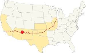
Location of Navajo on Route 66
The climate in Navajo is arid and dry. Summers are hot and winters cold. The day-to-night temperature swing is considerable throughout the year due to the low relative humidity; this means that Summer nights are pleasant and cool, but winter nights are quite cold.
The average high temperature during summer (July) is around 95°F (35°C) and the average summer low is approx. 59°F (15°C).
The winter (January) average high is 50°F (10°C); and the average low is 21.9°F which is below freezing (-6.1°C).
The arid area does not receive much rainfall, only 9.5 inches per year (240 mm). Half of it falls during the Summer Monsoon period from July to October (5 in. - 127 mm). There are some 49 days with precipitation every year.
Snowfall is light with about 6.5 in. per year (16.5 cm), which falls between October and April.
Tornado risk
There is almost zero tornado risk in Navajo: Apache County has no Tornado watches. The area west of the Rocky Mountains does not experience tornados.
Tornado Risk: read more about Tornado Risk along Route66.
Map of Route 66 through Navajo Arizona
Read the Detailed Description of this segment (Lupton to Winslow). Below is the interactive map:
>> Custom map of Route 66 in Navajo
This is the map of Route 66 from 1926 to 1961 through Navajo. At each tip of this segment the highway is now cut by the freeway; see the two missing segments marked with a brown line in our custom map.
Route 66 Alignment near Navajo
With maps and full information of the old roadway.
- Winslow to Winona (next)
- Lupton to Winslow (Navajo's)
- Albuquerque to Lupton (previous)
Navajo, Arizona, its Sights and Attractions
Tiny Town in the Navajo Nation
Historic Context
Jack Rittenhouse in his 1946 classic "A Guidebook to Highway 66" written in 1946 says the following about Navajo:
Consists of Marty's Trading Post, with gas and groceries; a small neat cafe in a house back of the trading post and five tourist cabins Rittenhouse (1946)
We will begin this leg of our Route 66 Road Trip coming from Chambers and driving west along the 1926-61 US66 alignment from I-40s exit 330. The road is unpaved, it is a backcountry rough trail so maybe you'd rather reach I-40 along the freeway.
Rio Puerco Gas Station
Here by Exit 330 Rittenhouse mentions the "Rio Puerco Service station; gas only." We believe that the gas station was located on the north side of Exit 330 (1969 aerial photo) though it could have been on the south side too. Both spots are shown in the images below.

Looking east from Rio Puerco gas station. St. view
Click on image to enlarge

Looking west from Rio Puerco gas station. St. view
Click on image to enlarge
The alignment coming from Chambers is now cut by the freeway at Exit 330, here, the original roadway that ran parallel to a long cliff, moves to the south side of I-40, the brown line in our custom map shows the gap in the road.
Head to the south side of I-40 and drive west along Hwy 7386, it is paved for about one mile to the McCarrell Memorial Cemetery, after there it becomes a rough, dirt-surfaced, back country trail So think twice before trying to drive along it. This segment to the town of Navajo is almost 4 miles long and is shown in this map (Exit 330 to Navajo). You can bypass it and reach Navajo along the Interstate. Take Exit 325.
The Painted Desert Inn (Gone)

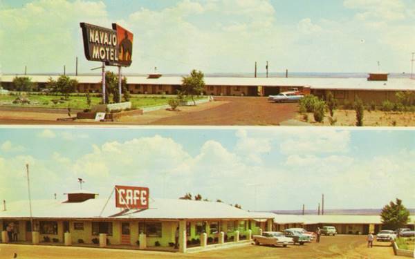
Postcard Painted Desert Inn, Navajo. Source
Pictured below in its heyday, the old motel has been torn down. It was built on the new alignment of Route 66 in the early 1960s or late 1950s. Originally named the "Navajo Motel" it had 20 units. It was described in the postcard below as " NAVAJO MOTEL, CAFE & SERVICE STATION Navajo, Arizona Curio Shop - Post Office On Highway 66-12 Miles east of the Painted Desert & Petrified Forest 20 large luxurious double and single units carpeted wall to wall - tile baths Cooled by Refrigeration."
Later it became the "The Painted Desert Inn" adding 5 units. It also had a Standart Oil service station, grocery store, curios and an RV park. Its neon sign depicted a tired Indian on horseback coming home at sunset.
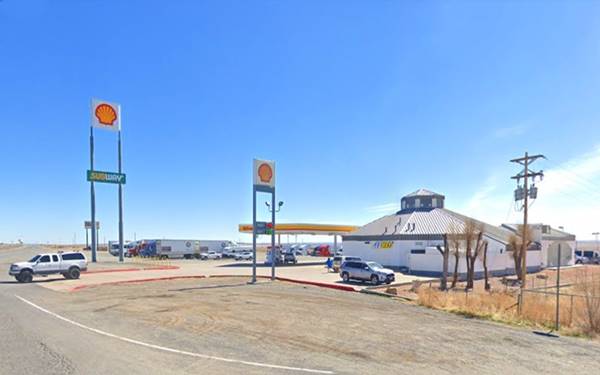
The building In its place is the "Navajo Travel Center".
Navajo Travel Center
I-40 Exit 325. Navajo, AZ. (928) 688-2334.
The Navajo Nation Tribal Council established the Navajo Nation Hospitality Enterprise as an enterprise of the Navajo Nation in 1982.
You can buy typical Native American crafts, horse hair pottery and Route 66 souvenirs. It has a gas station and a Subway sandwich shop.
The St. view of the Navajo Travel Center nowadays
Historic Marker
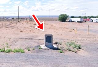
There is a Historic Marker at Exit 325; Park at the gas station and Navajo Travel Center and walk to it, it is to your right on the eastbound lanes of I-40 access ramp (map).
The inscription reads "December 29, 1863 Arizona's Territorial officials took the oath of office during a snowstorm. Governor John N. Goodwin and other officials arriving from the east by wagon train, took their oaths of office and raised the U.S. flag "to establish a government whereby the security of life and property will be maintained throughout its limits, and its varied resources be rapidly and successfully developed."

Map of US 66 in Navajo AZ, 1937. Source
The Village
Marty's Trading Post
Classic Navajo on Route 66 is located half a mile south of I-40s Exit 335 next to the railroad tracks and Rio Puerco. Here was the depot and the community sprang up next to it. Marty's Trading Post and gas station, cafe and cabins has vanished. And we have not been able to find pictures of the place, only a matchvover. The map from 1937 above, shows several stores along the highway, all of them were torn down over the years. The one marked with (5) for the amount of rooms, was Marty's.
This Aerial photograph taken in 1969 shows the freeway, the motel (top) and Navajo village (bottom), but most of the buildings on the SE side have gone as well as the depot. Only Marty's Trading Post (far right) was still standing at that time. This map marks the spot where some ruins of the old post can be seen.

Marty's Trading Post 1950s matchcover. Source

USGS map 1960s of Navajo
The USGS map, shows Marty's marked with a Green Arrow, and the original 66 alignment (blue arrows).
The "Navajo Springs"
Located 3 miles to the southeast of Navajo. This is the Map with Directions to reach the springs.
There is tall grass and during the wet summer period, it may get boggy. Check before visiting the spot.
Monument
There is a small monument next to a water tank at the springs, it was erected by the DAR (Daughters of the Revolution). It reads:
"ARIZ TERR GOVERNMENT ORGANIZED HERE DEC. 23, 1863."
Read further up, in our "History" section about this historic event.
Route 66 west of Navajo
The original 1926-61 highway 66 (dirt road) continues west of Navajo as shown in this Map followed by a gap caused by I-40's alignment and marked with a brown line in our custom map.
The dirt surfaced, back country road -rough and poorly maintained, continues westwards on the north side of the freeway as marked in this map all the way to Painted Desert Trading Post which is the next landmark mentioned by Rittenhouse in 1946
Read about all the Painted Desert trading posts on Route 66 west of Navajo. Check with owners before driving private roads or at the National Park if the road has restricted access.
Continue your Road Trip
This leg of your Route 66 road trip in Navajo ends here. Turn around and head back too the Freeway. You can head west into Holbrook and visit the Petrified Forest National Park (read below).
Your next stop: Holbrook, AZ. Route 66
National and State Parks, Outdoors
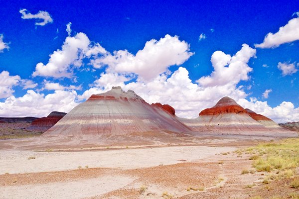
Petrified Forest National Park
Tip: consider visiting the Petrified Forest National Park (near Holbrook) on your Road Trip.
The Only National Park on Route 66
Some tours and sightseeing
Sponsored content
Lake Havasu City

Lake Havasu City, the lake, and London Bridge. Source
The resort town of Lake Havasu City on Lake Havasu has beaches along the lake's scenic shoreline, an active nightlife and the original London bridge (you can take a Tour to visit it)
The adjacent state park is open 24 hs, and there is an entrance fee. It is located on a reservoir on the Colorado River. You can hike and enjoy the riverside.
Visit the scenic shoreline with beautiful beaches, nature trails, boat ramps, and many convenient campsites.
>> Book your Hotel in Lake Havasu City
Learn more about the outdoor sites in the Havasu State Park official website.
>> Book your Hotel in Holbrook AZ

Credits
Banner image: Hackberry General Store, Hackberry, Arizona by Perla Eichenblat
Jack DeVere Rittenhouse, (1946). A Guide Book to Highway 66.


