Historic Route 66 in Kellyville
Index to this page
About Kellyville, Oklahoma
Facts, Trivia and useful information
Elevation: 785 ft. (239 m). Population: 1,150 (2010).
Time zone: Central (CST): UTC minus 6 hours. Summer (DST) CDT (UTC-5).
Kellyville is in Creek County between Sapulpa and Bristow on Route 66.
Kellyville's History
For an early history of the region visit our Tulsa webpage and our brief History of Tulsa.
James E. Kelly was the first settler in the area. In 1892 he secured a lease from the Indian Agency and set up a trading post close to Bakers Junction. In 1893 he moved the post east of its initial location to a site along the future railroad that would link Sapulpa with Oklahoma City.
The Name: Kellyville
Frisco railroad named the station after the first settler in the area: James E. Kelly, "Kellyville". Kelly is an Irish name, the original word in Gaelic is O Ceallaigh, or Mac Ceallaigh (descendants of Ceallach). Cellach in turn means "strife" or "contention".
A post office was established in Nov. 1893, with Kelly as the postmaster. In 1898, the St. Louis and Oklahoma City Railroad (later the St. Louis and San Francisco Railway or "Frisco") built a station at Kellyville. The small community grew and a bank opened and cotton gins were built near the railway depot.
In 1917 a terrible and tragic railroad accident took place in Kellyville when two trains collided head-on.
Oil was discovered in this part of Creek county in 1915, and it brought prosperity: by 1919 there was a refinery in Kellyville and also telephone service. Route 66 was aligned through the town in 1926, along the former Oklahoma Highway No. 7 that linked Sapulpa with Bristow.
The traffic along the Mother Road helped the economy during the period of the Great Depression (after 1929). But in the late 1950s, the Turnpike linking Oklahoma City to Tulsa was built, replacing Route 66, and it bypassed Kellyville. Traffic dropped and business dwindled.
Apparently there was a project to build an artificial ski resort in Kellyville during the 1970s, but it was dropped.
Population has grown slowly, from 647 in 1930 to 1,150 in 2010. And 97% of the employed residents, commute to work in Sapulpa or Tulsa.

Where to Stay
There are several hotels close to Kellyville in nearby towns along Route 66
> > Book your hotel in Tulsa
Lodging Near Kellyville
There are several hotels in the area close to this town. Alternatively you can also find your accommodation along Route 66 in the neighboring towns and cities. We list them below (listed from east to west):
On Route 66's Main alignment
Eastwards
Westwards
>> There are several RV campgrounds close to Kellyville in Tulsa, Bristow and Sapulpa
Kellyville’s Weather

Location of Kellyville on Route 66
The climate in Kellyville is temperate, with occasional thunderstorms, hail and tornados.
Average temperature in January is 48°F (high) and 27°F (low), that is 8.9 & -2.5°C. The average high and low for July are 92 and 71°F (34 & 21.5°C).
Rainfall is around 41 inches (1.040 mm) annually with late spring and summer as the wettest months (May, June and Sept.). On average there are 92 rainy days every year.
Snowfall: snow may fall at any time between November and March, and about 9.6 in. (24.3 cm) fall every year.
Tornados
Tornado Risk: Kellyville is located insided the "Tornado Alley in Oklahoma and faces about 10 Tornado watches every year.
Read more about: Tornado Risk along Route 66.

Map of Route 66 through Kellyville Oklahoma
Old Route 66 in Kellyville
At the end of the historic segment the highway takes a NE-SW course into Kellyville.
It was realigned after 1926, and you can still see two of the old segments of Route 66 in Kellyville: The first is on the north side of OK-66, east of the town, just west of Maple Dr. to your right on the north side of modern OK-66 is a curved paved segment; this is Map of it.
Another segment lies further west, to your left. It begins on the south side of OK-66, it is Oak Street, curving towards the railroad starting at Allen St. (See map).
Both sections were paved in Portland concrete in 1926.
A third section can be seen west of Kelyville, on the south side of the modern US-66 where Polecat Creek approaches the highway, it is hidden among the trees, it can be seen on its western tip (see image, red arrows). It crosses the road in a long S (it is marked with the blue line in this "missing segments" map that we prepared). You can also see it in this 1956 aerial photograph.
Continue west, and cross the interstate (see map) driving the 1926-65 alignment until you reach the historic segment.
Route 66 Alignment near Kellyville
Visit our pages with old maps and plenty of information of the old US 66 roadway.
- Chandler to Yukon (next)
- Tulsa to Chandler (Kellyville's)
Route 66 landmarks & attractions in Kellyville
Tours and things to see
- In Kellyville: Route 66 City tour, read below
- Outdoors and Parks
Jack DeVere Rittenhouse described Kellyville in his "Guide Book to Highway 66", published in 1946.
KELLYVILLE... cafes; gas; small garage; no tourist accommodations... A small community with about ten business establishments. Jack DeVere Rittenhouse, 1946
He also mentioned the now gone motel and gas station ("Gas station here, with a few cabins") 3 mi. east of Kellyville, which where we will begin our tour, and head west.
Rock Motel & Cabins
The image shows the motel complex in the 1930s, looking across Route 66, eastwards. It stood on the left side of the highway and was the work of Max Meyer, who owned 3,000 acres of land here. He also built the lake behind the complex, silos, bathouse, two service stations, tavern, dance house and the cabins, at that time it was a "Tourist Court" (the word motel hadn't yet been invented). Six gable roofed cabins built in stone with a fireplace.
You can see them in this aerial photo from 1957, and this is a map with their exact location. The site was razed in 2007.

Rock cabins and cafe, looking east across US66. Source
Blue Top Motel
Head west towards Kellyville. On the eastern side of the town to your right is the former "Blue Top Motel", it dates back to the 1970s, and had an L-shaped layout. The units on the western side of the property have been torn down and only the northern units and office survive. It is pictured above, now it is a self-storage business.
Oil Derrick
Just ahead, Route 66's original alignment forks to the left leaving the later (1938?) alignment, that heads straight westwards (see picture below). To your left is the "oil derrick."
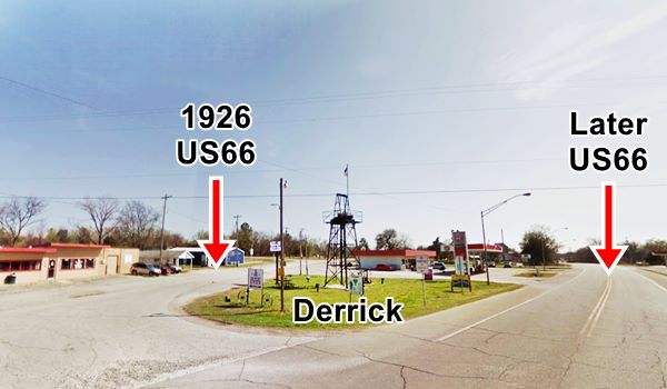
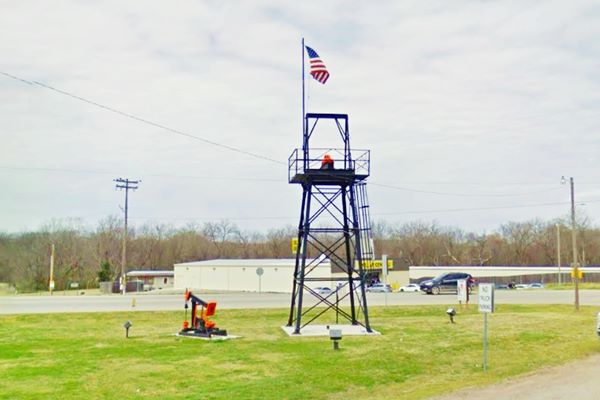
In 2013, a commemorative, 30-foot-tall oil derrick was added on the north side of Route 66 that was donated by a local resident Garie Henderson.
On the north side of Route 66, at stood the now razed "Cotton Gin".
Cotton Gin Site
There was a "Cotton Gin" in the center of the town, but it was demolished in 2011, another Route 66 landmark casualty.
A cotton gin is a machine that is used to separate the cotton fiber from the seeds. The fiber is used to make cloth and the seeds are the source of industsrial oil and animal feed.
In 1930, as the Great Depression began, there were four cotton gins in Kellyville. Now there are none.
This is a 2008 street view, while it was still standing.
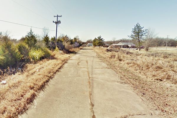
Old Route 66 roadbed
You can follow the original alignment for 0.2 miles on the north side of the town, then it ends and enters private property. Below is a view of the old roadbed.
Drive west along the later Route 66, leaving the town, and after 1 mile, to your left is the former refinery.
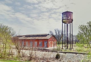
Remains of the Devonian Oil Co. refinery
Rittenhouse wrote back in 1946 that "just before you cross Little Polecat Creek is the Devonian Oil Co.". He was referring to the Devonian Oil company gasoline refinery with a 7,500 gallon per day refining capacity back in the 1930s. It owned oil leases in Texas, Oklahoma, Kansas and New Mexico, and another refinery in neighboring Stroud. The buildings are still standing, beside the railroad tracks. By the way, the 1917 train accident occurred here, at the Devonian Oil track spur:
Local History: the Kellyville Train Accident
The tragic train wreck that took place in 1917 was the worst train accident in Oklahoma
Tragic Railroad Accident of 1917
Oklahoma's worst train accident happened on 28 September 1917, at Kellyville. With a death toll of 32.

Kellyville Train Wreck, 1917. Source
Train No. 407 was heading westbound, from St. Louis to Lawton, Oklahoma, it had a steam engine and a steel baggage car; the other wagons were made of wood: mail car, two coaches, three sleepers, a chair car and an office car. The mail car telescoped into the first coach. Perhaps a steel coach would have reduced the fatalities.
Extra train 1322, was moving eastwards, an empty troop train returning to Fort Sill (it was used to move soldiers during World War I).
Unfortunately, there was another train in the area, Extra 1343. It had stopped at the Devonian Oil Co. siding to let Train 407 pass, and it was mistakenly identified by the engineers aboard Train 407 as Train 1322.
No. 407 kept on westwards and crashed into Extra 1343 head-on. The crew saved their lives by jumping off the train just before the collision.
The investigation showed that the enginemen had been sloppy in not clearly noticing that the train they had passed was 1322 instead of 1343. The conductor who had been dismissed before the accident had been reinstated as there was a shortage of conductors due to the War.
Read more: J. B. Calvert, (2002), Train Order Accidents.
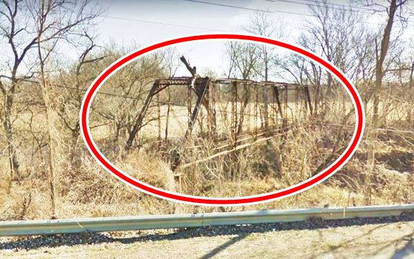
Haunted Crybaby Bridge
Optional side trip. Drive west from Kellyville along Rte.66 for 0.6 mi., and take a left southwards along Slick Rd., after 1.1 mi., at Polecat Creek you will see the old bridge on the left. Map with directions.
A Crybaby Bridge is a name given to certain haunted bridges, alluding to a local legend that a crying baby can be heard at the bridge because it died or was killed there, or thrown off the bridge.
Kellyvillle's Crybaby Bridge is another urban myth: a woman and her child were driving down Slick Road escaping from her husband, and she drove off the bridge into the stream below. The baby's body was never recovered. And its ghost remains there until this day, crying under the bridge.
Crybaby Bridge, Kellyville
Heyburn
Continue westwards, and 5 mi. from Kellyville, Rittenhouse mentioned that there was a "Gas station here, on the west bank of Polecat Creek. A sign indicates this establishment is the "town" of Heyburn." The gas station is gone (street view of the site).
You can see it in this 1956 aerial view.
Your Route 66 City Tour through Bristow ends here.
Head west along Route 66 towards Depew and drive the Bristow US 66 alignments.
Natural Attractions
Heyburn Lake Park
It is a reservoir on Polecat Creek just north of Kellyville. A spot for swimming, trekking, boating, fishing, camping, with RV park.
More details: Heyburn Lake U.S. Army Corps of Engineers
Some sponsored content
>> Book your Hotel in Tulsa

Source
Banner image: Hackberry General Store, Hackberry, Arizona by Perla Eichenblat
Jack DeVere Rittenhouse, (1946). A Guide Book to Highway 66
Linda D. Wilson, Kellyville, Encyclopedia of Oklahoma History and Culture
M. Bates Preposterous Papa: Max Meyer's rules for tourist court clerks, 2007


