Route 66 in Central Oklahoma
Index to Tulsa Attractions
On this page.
- About Tulsa
- Hotels and Accommodation in Tulsa
- Tulsa's Weather
- Map of US 66 in Tulsa
- Route 66 sights: What to see and do in East Tulsa
On our Tulsa Page #2
About Tulsa, Oklahoma
Facts, Trivia and useful information
Elevation: 722 ft. (220 m). Population: 411,308 (2024).
Time zone: Central (CST): UTC minus 6 hours. Summer (DST) CDT (UTC-5).
Tulsa is the second-largest city in the State of Oklahoma and 47th-most populous city in the United States. It is the county seat of Tulsa county. The Metropolitan Area of Tulsa had over 799,000 residents and spans Osage, Rogers, Wagoner and Tulsa counties.
Its motto is: "A New Kind of Energy" and its nicknames are "Oil Capital of the World", "Tulsey Town" and "T-Town".
Tulsa is the "Capital of Route 66"
The Tulsa Route 66 Commission, an official commission through the City of Tulsa, secured a copyright on the term "Capital of Route 66" after a process that lasted more than two years and involved exhaustive research and surveys led to the final approval from the federal government in April of 2024.
Tulsa Mayor G.T. Bynum said that "Tulsa and Route 66 are deeply connected with the Mother Road running through the heart of our city...Route 66 is an integral part of Tulsa's identity and we've long been known as the Capital of Route 66. To have this official designation is an exciting day for Tulsa, our region, and the state of Oklahoma." 2
Tulsa skyline

Tulsa's History
This part of America has been inhabited for over 12,000 years. The Native American people were hunters and gatherers. The Spanish reached the region in the mid 1500s but didn't settle it; the French fur traders arrived in the late 1700s as they explored the Arkansas River upstream in what was then the French Louisiana.
After the U.S. purchase of Louisiana in 1803, Oklahoma remained a remote area and was later designated as the "Indian Territory" that was to be used for the relocation of Native Americans, removed from their tribal lands east of the Mississippi River. Their forcible relocation took place in the 1830s and is known as the "Trail of Tears".
The Osage people
The Native American people known as Osage had settled in what is now Osage county, Oklahoma by the mid 1700s. But they had to cede their claim to their homeland to the U.S. government who in turn gave it to the Cherokee Nation that it was forcing to relocate in Oklahoma.
But the Osage eventually returned to Oklahoma and repurchased 1.57 million acres (6.400 km2) of their former land from the Cherokee. It became a reservation on 1875. This land is just northwest of Tulsa.
The Creek people
The Creek tribe lived in Georgia and traded with the British colony established there. After American independence, the new state of Georgia forced them to cede their lands through a series of treaties between 1790 and 1805.
Discontent among the Creek led to the Red Stick War (1814) and even more land cessions (1825). Finally the Federal Government signed a treaty with the Creek, that relocated them in the "Indian Territory" that would later become Oklahoma (1832). Finally, in 1836 they were forcibly expelled from Georgia and Alabama.
The Lochapoka Band of Creek Indians settled in 1828-36 in what is now Tulsa; their village was located close to present Cheyenne Ave. and 18th St., under an oak tree, the "Creek Council Oak Tree."
The Name Tulsa
Tulsa is the name that the Creek Indians gave to the village they established there in 1838; it was called "Tallasi" or "Tulasi" which means "old town" in Creek language. The same word is the origin of the name of Tallahassee in Florida
A U.S. Army party explored the area in 1832, camping in what is now Washington Irving Park (after the famous writer who accompanied the party).
Lewis Perryman set up a trading post in the village in 1846, he was part Creek. The town grew with cattle trading, and a post office was opened here in 1879; one of Lewis' sons was postmaster.
The Atlantic and Pacific Railroad which would later become the St. Louis and San Francisco Railway reached Tulsa in 1882.
Tulsa was incorporated in 1898; and the first oil well (Sue Bland N°1) was drilled in 1901, starting the oil-boom.
Population began to grow rapidly, from 1,390 in 1900 to 141,258 in 1930). By 1917, Tulsa called itself "The Oil Capital of the World," and oil drove its economy.
Route 66 was aligned through the town in 1926, promoted by a local Tulsa businessman, Cyrus Avery, now known as "The Father of Route 66" who was part of the Committee that drew its alignment.
Racial Strife
The African American community in the Tulsa Greenwood neighborhood was prosperous and peaceful, but the "Tulsa Race Riot" of May 31 and June 1, 1921 saw civil disorder and whites attacking blacks. The official toll was 39 dead (23 of them blacks), but the actual figure was closer to 300 dead (mostly black). 35 city blocks were burned and 10,000 people left homeless.
Oil wealth helped the town weather the Great Depression and the Dust Bowl, both of which hit the nation and Oklahoma hard during the 1930s.
After World War II, Route 66 became saturated with traffic; it was also unsafe, so in 1957 Oklahoma built the Turner and the Will Rogers Turnpikes linking Oklahoma City to Joplin, Missouri running through Tulsa. The multi-lane highway bypassed the old segments of Route 66.

Lodging in Tulsa: Where to Stay
There are plenty of hotels and motels in Tulsa, you can take your pick and easily find your room.
> > Book your Hotel in Tulsa
Route 66 Accommodation close to Tulsa
There are several hotels in the area close to this town. Alternatively you can also find your accommodation along Route 66 in the neighboring towns and cities. We list them below (listed from east to west):
On Route 66's Main alignment
Eastwards
Westwards
>> There are several RV campgrounds in the Tulsa area.
The Weather in Tulsa

Map showing the location of Tulsa, Ok on U.S. 66
Tulsa has a temperate climate with rainfall concentrated during spring and summer, with occasional thunderstorms, hail and tornados.
The average high temperature in January is 48°F and the low is 27.5°F (8.9 and -2.5°C). In July the average high and low temperatures are 93.1 and 71.3°F (33.9 and 21.8°C).
You can expect an average of 11 days per year with temperatures over 100°F (38°C).
Rainfall is 41 inches per year (1.041 mm) with most rain falling during May, June and Sept. There are 93 rainy days a year. Snow: 9.6 in. (24.3 cm) per year, between Nov. and March, the record: 29.6 inches in one year.
Tornado risk
Tornado Risk: Tulsa lies within the "Tornado Alley in Oklahoma and experiences some 10 Tornado watches every year. Read more about: the risk of Tornadoes on Route66.
Map of Route 66 in Tulsa Oklahoma
Below are links to the detailed description of the alignment of Route 66 into and across Tulsa, as well as interactive maps.
>> Vinita to Tulsa - Map of this segment
>> Tulsa to Chandler - Map of this segment

1924 Auto Trails map in Tulsa. Source
When US Highway 66 was created in 1926 it was aligned along the previous state highways. These in turn had been built along the original roads in the region. The map below shows these first highways, called "AutoTrails". They were paved and unpaved roads that could be driven relatively safely by cars. This map was published in 1924, only two years before Route 66 was created. In Tulsa, trail #50 would carry Route 66, the "Ozark Trails" and westwards it overlapped Trail #57 "Stapleton Roads" into Oklahoma City.
Summary of US 66 alignment into Tulsa
Route 66 reached eastern Tulsa from Catoosa from 1926 to 1959 using 193rd St. southwards, then a right onto 11th St., westwards all the hway to Mingo Rd.
>> teal line in our custom map is the 1926-59 US66 into Tulsa.
At Mingo Road if followed two alignments into Tulsa:
Original 1926-32 alignment. Along Mingo norhtwards, then took a left along Admiral Place. A left onto Lewis and a right along 2nd, into the town. Then: Detroit, 7th, Cheyenne and 11th Street, to Maybelle and then across the 11th St. Bridge. On the western side of the River it followed Southwest Blvd. (in those days Quanah Ave.)
>> violet line in our custom map is the 1926-32 US 66 across Tulsa.
1932 to 1959. It was realigned west of Mingo Road along 11th St. into downtown. Meeting the previous alignment there.
>> yellow line in our custom map is the 1932-59 US 66 across Tulsa.
1926-59 Arkansas River Bridge. The highway went along 11th St. and turned south across the historic bridge. The western part of this alignment is now cut by Exit 4C of I-244 and the historic bridge can't be driven. A new alignment carries Route 66 across the Arkansas River using W 12th st. But this wasn't the historic alignment.
>> green line in our custom map is 1926-59 original US66 Arkansas River segment.
After 1959. With the Interstate I-44 there were more changes: I-44 became the Route 66 and 11th St. was Bus. 66 until deleted in 1973.
West of Tulsa
>> navy blue line in our custom map is the bridge and gap at the Arkansas River.
The old historic bridge that carried Route 66 is still there, but closed to vehicles. The exchange at I-244's Exit 4C removed the curve where the 11th St. alignment curved towards the bridge.
Westwards from the bridge there have been three alignments over the years:
1926 to 1951
US 66 turned sharply south along Quanah Ave., current Southwest Blvd. which curved with a SW course becoming Sapulpa Rd.
It went through Red Fork (at W 41st St.) and curved along Southwest Blvd. and Frankoma Rd. through Oakhurst all the way to Sapulpa. It can be driven.
>> pale blue line in our custom map is the 1925-51 Tulsa-Sapulpa alignment.
1951-59
From 48th St. the highway forked and ran next to the Turner Turnpike along what is now OK-66 (New Sapulpa Rd.) that was a 4-lane roadway. It met the older alignment in Sapulpa.
>> red line in our custom map is the 1951-59 Tulsa to Sapulpa US66
1959 onwards
US 66 shifted its course to I-44 in Tulsa metro area.
Route 66 Alignment near Tulsa
Visit our pages with old maps and plenty of information of the old US 66 roadway.
- Vinita to Tulsa (previous)
- Tulsa to Chandler (Tulsa's)
- Chandler to Yukon (next)
Tulsa's Route 66 landmarks & attractions
Sights in Tulsa
Those marked with ✤ are on Tulsa's second page.
Historic Context Route 66 in Tulsa: 1946
Jack DeVere Rittenhouse wrote about Tulsa in his classic "Guide Book to Highway 66", which he published in 1946 after driving Route 66 all the way from Chicago to Los Angeles. It gives us an idea of what it was like in Tulsa during US-66's heyday.
Rittenhouse tells us that 15 miles east of Tulsa US 66 and OK-33 intersected, and there were "Gas, garage and cabins" there. One mile ahead the road turned sharply west and two miles west, ran through Lynn Lane, a small community with "several gas stations, a small garage and several homes. KVO court here".
In Tulsa Rittenhouse mentions the following:
Several hotels including: Adams, Alvin, Bliss, Bradford, Cadillac, Corona, Tulsa, Mayo, Mercer, Oklahoma, Plaza, Seneca and Wells; courts include: Cook's, Park Plaza, Anchor, Baker's, Blue Jay, Campbell's, El Reposo, Mid-Way, Rio, Shady-Rest, Tulsa, Whitt, Will Rogers, Grotto... garages: McGee, Apache & Cinn, Hocker...
two miles from the center of town, your pass a shady Park (R) occupying a city block... From this point... the highway is flanked with a constant succession of business establishments tourist courts, garages, gas stations, etc.
At 2 mi... your pass the Crystal City Amusement Park (L). Soon afterwards you enter the suburb of RED FORK, an industrial suburub of Tulsa containing many factories. Rittenhouse (1946)
Tulsa's Attractions: East side to Downtown
Lynn Lane
Georgia's Cabins and Standard Station
Coming from the east from Catoosa, drive south along 193rd Street and then take a sharp right turn along E 11th Street. This is where Rittenhouse placed the small community of Lynn Lane. Just ahead to your right is a former old Gas Station and Cabins at 17501 E 11th St. It can be seen in this 1958 aerial photo shows the gas station, with the two cabins on its left side (west) and the garage behind it.
The vintage postcard below shows the same four buildings (same view nowadays).

The cabins are gone, the garage behind the station is there, but, like the filling station has now been greatle altered. The pumps area under the gabled canopy was enclosed with red bricks. It had already been modified in the 1980s, replacing the flat canopy with a gabled one. The 2016 image shows it before it was modified, with empty pump islands and the broken sign is rusting away.

Old gas station in 2016. Click image to enlarge. St view
K.V.O. Modern Courts later Brookhaven Motel
The KVO court mentioned by Rittenhouse in 1946 was also here, on the north side of the highway, to your right just west of S 157th Ave. at 15606 E 11th St.
The postcard below states the following: "E.F. Schmidt Proprietor, Reasonable Rates, 5 1⁄2 miles east of Tulsa." The stone buildings are still standing. Notice the same hip roof shape and disposition of the double doors on the cabin is the same as in the postcard. The 1926-70 Oklahoma Route 66 Historic Resources Survey lists it as Brookhaven Motel.


Toby's Beauty-Rest Court

Head west. To your left on the SE corner with 133rd E Ave. at 13300 E 11th, is a property dating back to 1935.
The original office is the sandstone building on the left. Another one has been added to its western side.
The cabins are located behind, in a semi-circle, and now serve as apartments.
Billy (Toby) Young ran it with his wife Dolly Dresser in 1944; Toby was "recreation manager for the two Douglas Aircraft plants" in Tulsa. 1
The postcard below shows that it also sold Phillips 66 gas.
Molder Court (Gone)

Molder Tourist Court. Source
Continue west; to your left, at 13100 there was another motel (shown in this 1954 aerial photo).
It had six bungalows set around a central courtyard. The location, and layout match the 1940s postcard of Molder Court.
It was owned and operated by James Phipps and his wife Hazel (Syverson) Phipps who, in 1947 bought the property in partnership with Sy and Edith Syverson, Hazel's brother and his wife.
It was torn down in the late 1980s.
Bates Hotel (Gone)
Ahead at 12303 11th St., where the used boats and car lot is now located, was the Bates Tourist Hotel. The first hotel here was the Pierce Pennant Terminal built in the 1920s. William Clay Pierce, partner of Pierce-Pennant Oil Co. had the vision of building integrated and self-contained stopping points along Route 66 from Chicago to Los Angeles. They would include a luxurious motor-hotel, restaurant, and a full service gas station. He opened the first one in Springfield Missouri, followed by one in Rolla, one in Pond, near St. Louis. By 1929 there were more in Oklahoma, Texas and New Mexico. But the Great Depression hurt business in 1930 and Pierce sold out to Sinclair Refining Co. Hard times hit the company and it went bankrupt in 1933. The Bates closed in the 1960s and was torn down. (aerial photo from 1954). The hut on the far right of the image was a Pierce-Pennant in the 1920s, later a Sinclair gas station, and a Phillips 66 in the 1950s.

Route 66 Eastern Gateway
As you approach I-44, to your right at 11601 E 11th St. is the gateway. Pictured below. The Route 66 Western Gateway is on the other side of town in Western Tulsa.

Brookshire Motel (Gone)
I-44 was built across Route 66 around 1957, and on its western side, there are, left and right two gas stations with long flat canopies spanning dual pump islands; they were built in the early 1960s. To the right, adjacent to the Sonic, at 11017 E 11th St, was the now gone Brookshire motel
This motel closed in 2010, and had a classic neon sign and an appealing cottage styled office that served as home for the owners.
Cecil and Gusetta Brooks owned and operated it after buying the motel here at "Dead Man's Corner" back in 1950. In 1955 11th St. was widened from 2 to four lanes and the motel lost six units to make way for the wider street. The Brooks sold it to Jerry Gordon in the early 1970s, and business slowed until it closed. It was gutted by a fire in 2019 and again in 2020. The building had to be torn down.
Brookshire Motel in Tulsa before it was torn down


Apparently the last owners of the motel, the Nathu Patel family sold the neon sign to David Silver of Plano, Texas.
Saratoga Motor Hotel
Ahead at 10117 E 11th St. is the former Saratoga "Motor Hotel," what we now call a motel. It had "85 rooms with a 24-hour Resturant, Circulating Ice Water, Continuous Hi-Fi Music and Radio, Large, Heated Pool and 1-Day Laundry Service. Credit Cards Honored and Free Airport Transportation."
It became the America's Value Inn, but it closed. The original neon sign is basically still there, though redesigned and modified.
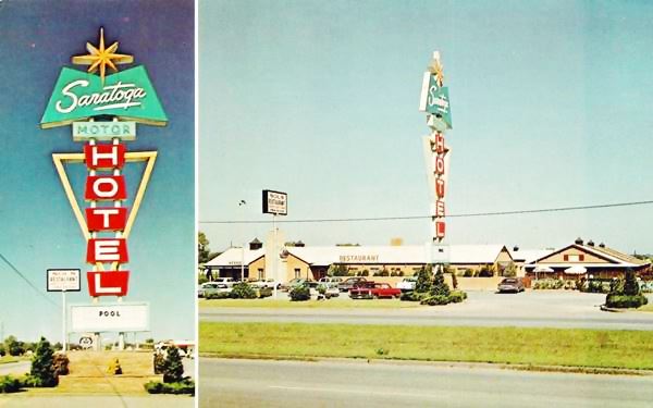
Below is a recent (2022) view of the old neon sign.
Mingo Road
On the next block, to your right at 9939 E 11th, on the NE corner with S 101st Ave is a former Phillips 66 Station with its typical canted plate glass office resembling a 1950s contro tower. Now an auto repair shop (St. view).
Ahead, at Mingo Road (9701 E 11th St.), U.S. 66 met U.S. 75. The original alignment of Route from 1926 to 1932 turned along Mingo Rd. norhtwards, and then took a left along Admiral Place westwards into Tulsa.
After 1932 it continued straight along 11th St. westwards.
Interpretative Plaza
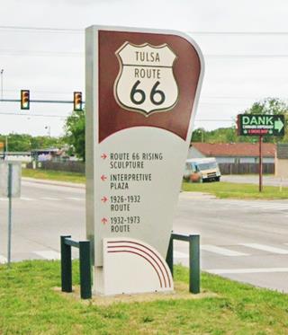
In the median strip of 11th St. here at Mingo Rd. there was a sign marking the 1926-32 alignment (right, along Mingo "Greenway"), the 1933-73 alignment (straight ahead on 11th St.) and to the left an arrow pointing south towards the "Interpretative Plaza" located 400 ft south, in the J.D. Metcalf Arbor Garden Park. It consists of five concrete pedestals emblazoned with Route 66 shields, each one has a bronze plaque that mentions Route 66 and Tulsa's history. Picnic spot and parking available.
The sign in the median pictured above shows the original course and some sights along it. There is "Historic Route 66" shields marking the later alignment too (pictured).
Side Trip to the 1926-32 Alignment
Take a 5.1 mile round-trip detour to visit two Classic spots on the first alignment of Route 66 in Tulsa. This is the Map with Directions.
Route 66 Rising Sculpture

Route 66 Rising. Source
Turn right along Mingo Rd. and head north; 0.8 mi north, at the Admiralty Pl. roundabout is a new sculpture completed in December 2018 on the "Cyrus Avery Traffic Circle."
It is a gigantic sculpture, 70 feet wide and 30 feet high. it cost $655,000 and was designed by Eric F. Garcia from Albuquerque NM.
This Roundabout known as Avery Traffic Circle, is the site of what once was the Cyrus Avery motel, inn and gas station. Cyrus Avery, a native from Tulsa, is well known as the "Father of Route 66".
Hank’s Hamburgers
Turn west at the roundabout on Admiralty Pl. to visit Hank's Hamburgers at 8933 E Admiral Place Tulsa
Located on the north side of the road, it has been serving ham burgers, malts, and shakes since 1949. Even though in those days Route 66 had moved south to 11th St., it catered to locals and customers driving down US 75 or OK-33 into Tulsa.

Admiral Twin Drive-In
Route 66 Roadside Attraction
Turn right at Memorial Dr., cross the freeway and turn left at Easton St. to see a unique Drive-in theater at 7355 E Easton St.
It was built in 1951 and is one of the few drive-in theaters that have survived in Oklahoma.
With a capacity for more than 1,000 cars it is the largest drive-in theater in the state. It has a dual 9-story pair of screens with the place's name written in large red letters..

Your side trip ends here. Turn around and head back to 11th and Mingo to turn right and head west into Tulsa along the 1933-73 Route 66.
1933-73 Route 66 along 11th St.
Westwards towards Tulsa
Former Service Station
On your right at 9347 E 11th St is a liquor store "Mad Dog Liquors" which used to be a gas station. It still has a canopy over the concrete island that once had gas pumps. See its Street View.
Just ahead, also to your right is a Classic Motel and Neon Sign.
Oasis Motel
Classic Neon Sign

Oasis Motel's original Neon Sign. Source
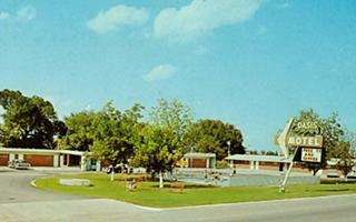
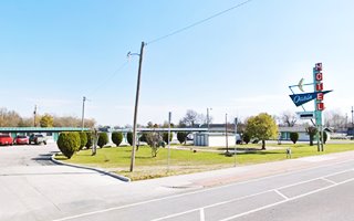
At 9303 E 11th St, Tulsa. This motel was built in 1953. The Walkers ran it in the 1960s. The current neon sign dates back to 1960.
The postcard further down, postmarked in 1962, tells us that it had "Swimming pool - Room Phones - Room Coffee Service - Lounge".
It has a great neon sign which, rather suprisingly, is very different to the original one as you can see in the "Now and Then" sequence above.
Usually the modern sign is uglier than the original one, in this case it is the opposite. There was a pool in the front lawn, which has now gone.
The current neon sign is a googie style favored in the early 1960s, so it probably replaced the original one at that time. The "boomerang" on the sign is great!
Just ahead is the former Philbeck Motors Texaco from the late 1950s (it can be seen in a 1958 aerial photograph) now a used car dealer; 9137 E 11th St. Pictured below.
Elm's Court (Gone)
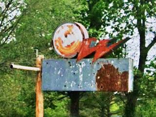
To your left, at 8344 E 11th St. was Elm's Court with its rugged stone cottages that can be seen in this street view in 2019, two years before it was torn down to make place for an RV sales lot. Fortunately, the neon sign is still standing, rusty and faded, with a W-shaped squiggle on its upper side.
Manor Motel (Gone)
Ahead at Memorial Dr., on the NE corner with 11th St. was the Manor Motel at one time owned by James Norcom. Its postcard says it had "most unusual decor, free room phones - Wood Burning fireplaces." It was torn down in the late 1980s.
Across the street on the NW corner was the US 66 Café.
Tulsa Ranch-O-Tel (Gone)
On the SW corner, at 7930 E 11th St. it had an L-shaped layout facing both streets and a large open courtyard and "... carpeted floors, refrigeration cooling, Safe-Aire heating, garages, tile baths..."
Continue west for 1 mile and at 6327 E 11th St. was Parkey's Restaurant that closed in the mid 1970s and housed others over the years till the building was torn down in 2010. See Parkeys "Then and Now" in this 2007 St. view while it was still standing and late 1950s view of it.
Sheridan Hills Motel
Across from Parkeys, to your left (6302 E 11th St) is a classic motel, currently the Super 11 Inn, it used to be the Sheridan. Its postcard tells us that it had all the comforts a traveler needed: "East edge of Tulsa York Air-Conditioning - Thermostat Heat control - Wall-to-wall Carpets - Tile Baths - TV's." Pictured above, and below; changed but still hanging on.
Sheridan Hills Motel 1950s postcard in Tulsa, Oklahoma

Cook's Court "Trav-O-Tel" (Gone)
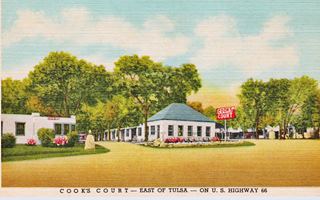
To your left at 5900 E 11th St (5946 on other postcards) to your left on the south side of the highway was this auto court that had 38 units (at one time 45!), and a cafe; also known as "Cooks Court" It was owned by E.L. "Gene" Roop. Mill Creek bounded it on the west. Razed in the 1970s.
Flamingo Motel
To your right, across from the old Cook's site, at 5915 E 11th St. is the former Flamingo Motel. Still operating as a motel, now it is the Western Inn. The postcard below tells us that it was "On U.S. 66, 10 minutes from downtown Tulsa, Oil Capital of the World. Phone TE 5-7647. A first class motel. Room phones, free television and radios, Refrigerated air conditioning - wall-to-wall carpeting, Tub Combination Tile bath, and lots of Hospitality. Visit the Gilcrease Indian Museum, Nationally famous. Heated swimming pool - new restaurant serving fine food, one block. AAA Approved."
It's classic neon sign is gone (it was blown down in a storm) and the pool has been filled in.

Four motels and a Restaurant, all gone
At 5728 E 11th, to your left is Texaco Service Station with its porcelain enamel panels, with green bands running along the upper part of the parapet. This is a 1950s gas station (street view).
Will Rogers Motor Court (Gone)
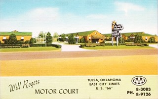
There were also two motels on the 5700s block, both gone; at 5737 E 11th St was the Will Rogers Motor Court it opened in 1941, with 36 units. Dora and Paul Johnson ran it after 1947; its postcard promised "Tub and Showerin each Unit. Year 'round air conditioning. Individual Thermostats." Next to it was McCollum's Restaurant.
Tulsa Motel (Gone)
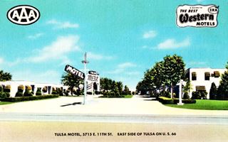
At 5715 E 11th St. was the Tulsa Motel that opened in 1941 with 20 cottages, grew up to 82 units. Now a used car lot. It was "Recommended by Duncan Hines, member of AAA and Best Western Hotels" offering "Private Inside Entrance - Goodyear Air Roam and Beautyrest Mattresses - Radios...." All of them are long gone.
Grotto Courts
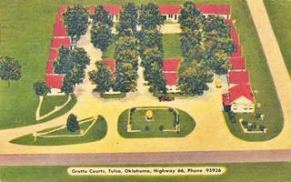
The next motel was the Grotto Courts at 5527 E 11t Sth., with "30 units- All air-conditioned - All tile Baths."
Whitt's Motel (Gone)
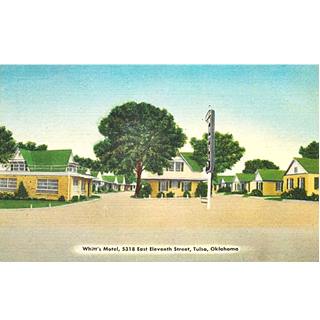
Located at 5318 E 11t, it offered "sound-proofed rooms, steam heat... easy chairs, reading lights, excellent beds." Later, in the 1950s it became the Bel-Air motel (see 1950s picture). It was razed in the 1980s.

Grotto Courts c.1940s Tulsa. Source
Desert Hills Motel
Classic Neon Sign
On the next block, to your left, at 5220 E 11th St, this motel opened in 1957. Still open and with a classic neon sign (pictured above and below).
Its postcard pictured in the "Now and Then" sequence below announced: that it had "50 beautiful units... Free morning cofee served in Lobby - Fine Restaurants within walking distance"

Viewed from the same angle today, the pool seen beyond the sign is gone and the canopy is now shorter.

Side Trips to a see two Wacky Route 66 Sights
A Giant statue and enormous praying hands
Turn south on Yale Ave., see this Map with Directions for a short 3 mile round-trip to see an Example of Americana and a Wacky Route 66 sight.
Golden Driller
An Oklahoma State Monument: Americana and Kitsch
21st St. and Pittsburgh Ave. Tulsa County Fairgrounds.
The first "Golden Driller" was built for the 1953 International Petroleum Exposition as a symbol for the "Oil Capital of the World". It was such a success that it was used again in 1959.
Its owner and sponsor, the Mid-Continent Supply, donated it to the Tulsa County Fairgrounds Trust Authority and built the current and permanent version for the 1966 Expo.
It is 76 ft. (23 m) tall and designed to withstand winds of up to 200 mph. It contains 2.5 miles of steel rods and mesh and is covered in concrete. Its hand rests on a real oil derrick.

Golden Driller, 76 ft. tall. Source
It is said to be the largest free-standing statue in the world and weighs 43,500 lb. (19.7 MT).
Praying Hands
The second spot is further away from here it is a 14.6 mile-long round trip; see this Map with Directions to visit the "Praying Hands".

Praying Hands Sculpture, Source. Click image for St. view
Tulsa is known as the "buckle of the Bible Belt" and it is the site of Oral Roberts University and the university's "Prayer Tower" (street view" of this space-age inspired, Googie styled glass and steel tower, 200 ft. tall built in 1967).
At the entrance to campus is the statue of the "praying hands;" 60 feet (18 m) tall and the largest bronze sculpture in the world, it was cast in Mexico in 1980.
There is another Route 66 sculpture of praying hands in Webb City, Missouri.
Retrace your steps back to Eleventh Street and continue driving west into Tulsa.
Along 11th St. into Tulsa
Route 66 Tulsa
Once you finish the side trip, return to Yale and 11th Street, turn west (left) and continue your journey into Tulsa.
Great Classic Neon Sign
Neon Sign
At 4507 E 11th St. Tulsa; it dates back to 1950 and is a used car dealership sign. It has two slanted steel supports crossed by a red arrow and a yellow "boomerang" with two green bands linking them together.
Sinclair Service Station
Listed in the National Register of Historic Places
To your right, at 3501 E 11th St. Now restored and serving as the offices of Rossi Brothers, this station pictured below was built in 1929, it is a house with service bay station in a Spanish Eclectic style typical of Sinclair. Another example of "home-like" stations built to blend in with an urban setting. It is contemporary with the "Tudor Revival Cottage" styled gas stations favored by Phillips and Conoco (there are two of these "cottage" stations in Tulsa).

Former Shell Service Station
Just two blocks west, on the SE corner of Harvard at 1107 Harvard Ave. is a Cottage style station
To your left, on this former cottage style gas station now an insurance broker office and was located on a strategic corner. The design was used Shell during the 1930s and this was the "Shell Oil Co. Filling Station No. 5."

Safeway store, Tulsa c.1940. Source. Click image to enlage
At 3140 E 11th was a Texaco Station, the chamfered corner office on the right side is clearly visible, Now an eating spot. The deck stands on the area in front of where the service bays were. This is its St view.
Campbell Hotel

The 1927 former Casa Loma Linda, now Campbell Hotel, Tulsa.
Listed in the National Register of Historic Places
At 2636 East 11th St. Tulsa. Built in 1927 this classic and recently revamped hotel is a half-block-long building along what was then Route 66.
It was the work of Maxwell "Max" W. Campbell (1895-1970) who, in 1921, bought a 10-acre tract of land here and went on to create Tulsa's first suburban shopping center. The red-brick building complex was known as the Casa Loma.
It had barber and beauty shops, a drug store on the eastern corner, and a grocery store on the western tip (a Safeway in the 1940s pictured further up). The "Casa Loma Hotel" was located on the second floor; all the commercial space was at street level. It is an example of the Mission - Spanish Colonial Revival style.
For many years it was the "only hotel" east of town. It was restored and is once again operating a hotel.
Below is another view looking west, notice the D-X gas station to the right. This is the same view nowadays.

Borden's (Gone)
Across from the hotel, at 2615 E 11th St. was Borden's. Leroy and Richard Borden opened their first eating spot in Tulsa in 1935. They grew it into several locations across town. The one on 11th St. offered "Broiled choice steaks. French fried shrimp, fried chicken or dinners served with "truly delicious coffee" that will highlight any meal." They gradually closed, the last burned in 1985. There is a marker at this site on Route 66.

On the SW corner with Atlanta Ave (2446 E 11th St) was Lockhart Oil Co.'s service station. It originally consisted of the cottage style building on the corner, and later two large brick service bays were added on the right side of the building. Neatly maintained and repurposed as a coffee shop.
S Lewis Ave and E 11th St
Ahead, on the SE corner of S Lewis and Route 66 there was a Phillips 66 station, a company formed by Frank and Lee Eldas Phillips. Across, on the SW corner there originally was a Waite Phillips Service Station No. 11 (1102 S Lewis). Waite Phillips (1883-1964) was the younger brother of Frank and Lee. He had worked for them, but set up his own oil company that he sold in 1925. This station later became a Mobil gas station and the building, though altered has survived. There was another filling station on the NE corner that has also survived.
The Meadow Gold Neon Sign stood on this corner from 1934 until 2004 when it was taken down, preserved and restored as the building on which it had stood was demolished.

Historic Tulsa Monument Company Building
Listed in the National Register of Historic Places - Art Deco
Drive 0.4 miles west, and at 1735 East 11th St, to your right, is this building erected in 1937. The Tulsa Monument Company Building is a good example of Streamline Moderne style architecture.
It has a symmetrical facade, a rectilinear geometry with its triple banded pillar caps (known as the "3-Bar Modern" style) and the gray trim contrasting with the white plaster concrete. It was designed by Harry Mahler to look like a monument, and this was appropriate because the Tulsa Monument Company, owned by Edwin and Jessie Holmes produced cemetery monuments, memorials and mausoleums (it also sold granite and marble for buildings).
Tulsa Monument Company Building in Tulsa, Oklahoma

Old Cities Service Gas Station
1502 E 11th St. Tulsa. This is a former Cities Service Gas Station from 1933 designed in Art Deco style by M. R. Pettingill on a corner location (to your left), with a two-bay garage and a glazed office. No canopy. It is pictured below before it was modified and converted into a Pizza Restaurant (current view).
The Tulsa Preservation Commission listed it as part of the city's Art Deco heritage. The aluminum-framed windows and rollup curtains on the service bays were later additions.
Stunkards Service Station
To your right, at 1401 E 11th St. was Stunkards Super Service Station built in the commercial block style with a covered sidewalk supported by massive brick columns c.1935. The parapet has brickwork decorations. The place was modified into a small mall in 2020 and subdivided into shops that converted the service bays into large windows. Below is its current appearance and how it looked before the changes.

Buck Atom's Cosmic Curios on 66
Wacky sight on Route 66
At 1347 E 11th St. Tulsa. It is a former Pemco station, an independent operator that was taken over by Fina around 1960. It as been refurbished and is now a shop selling Route 66 memorabilia: Buck Atom's Cosmic Curios.
It also has a great retro neon sign.
The store owner, Mary Beth Babcock conceived Buck Atom, the Cosmic Cowboy when she operated a downtown boutique (2006 - 2016), and she made him something real: a modern day muffler man.
The brand new statue is 21 feet tall (6.4 m) and is the work of Joel Baker (he owns American Giants, a company that restores Muffler Men) and artists Mark Cline and Chris Wollard. They worked together to create the statue.
In June 2024, a second statue was added; a 20 foot tall Space CowGirl, "Stella".
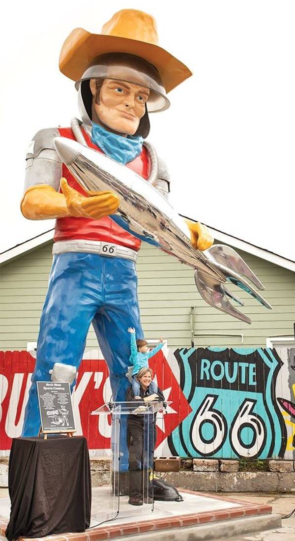
Below are two views of Stella.

Stella the Space Cowgirl, Tulsa, Route 66. Source

Stella Space Cowgirl, Tulsa, Route 66. Source
>> Learn about all the Muffler Men on Route 66
Meadow Gold Neon Sign
Ahead, to your left, on the 1300 block, on the SW corner of E 11th and S Quaker Ave. The Meadow Gold brand of milk and ice cream once belonged to Beatrice Food Company and was popular in the mid-western market in the years after World War II. This is the original sign that loomed over the intersection of Lewis Ave. and 11th just west of here from the mid 1930s until 2004, when the building where it was mounted was sold and demolished.
The new owner of the lot gifted the sign and its supporting structure to the city. It was dismantled and structurally restored to retain its original look.
It was set up again here to greet visitors entering the city as it did in the past.
Meadow Gold Neon Sign in Tulsa, Oklahoma

Brilliant Bronze Gas Station
At the next corner with S. Peoria Ave is an Art Deco former gas station at 1303 E 11th St. This former 3-bay garage gas station is closed, the Oklahoma survey named it Brilliant Bronze Service, later it was "The Wrench", an auto repair shop. The classic lines of the rectangular building are clearly Art Deco: black tiles on the lower part of its facade, glass brick windows, a "3-Bar frieze" on the upper part of the facade.

The highway passes by the cemetery, then under U.S. 75 ⁄ I-444 and ahead it enters a roundabout at S. Elgin Ave. where Route 66 now leaves E 11th St. to head west along E 10th St. here there is another Art Deco building.
Warehouse Market Building
Art Deco
To your left at 401 E 11th, this one-story building (pictured) has an ornate entrance and a slender terracotta tower. It was designed by B. G. Noftsger and constructed in 1929. It served as the main grocery supply for Tulsa during the 1930s and was known as "The Farmer's Market". The decorations include two medalions beside its entrance, placed on large blue panels. The building's facade has been preserved; notice the artowrk along the top of the parapet.
This ends the Route 66 tour of Eastern Tulsa.
Continue your tour in Downtown and Western Tulsa
At this point you have two choices (you can do them both in the sequence you prefer) to keep on discovering and exploring Tulsa and its Route 66 attractions.
We describe both of them on our Tulsa Page 2
- Head west, leaving the downtown district and crossing the Arkansas River driving west along Route 66 into Western Tulsa.
- Visit the sights in Dowtown Tulsa and the original 1926-32 Route 66 alignment there.
More Tulsa attractions on the Next Page
We describe the rest of Tulsa's attractions on Tulsa Page 2
Some sponsored content
>> Book your Hotel in Tulsa

Credits
Banner image: Hackberry General Store, Hackberry, Arizona by Perla Eichenblat
Jack DeVere Rittenhouse, (1946). A Guide Book to Highway 66.


