Index to this page
Route 66 from Vinita To Tulsa OK
Oklahoma Route 66 Itinerary and maps
Each leg of Route 66 described below has an interactive map and many image maps so you can follow the alignments of the highway along the way:
- KS-OK state line to Vinita - map of this segment
- Vinita to Tulsa - Map of this segment
- Tulsa to Chandler - Map of this segment
- Chandler to Yukon - Map of this segment
- Yukon to Clinton - Map of this segment
- Clinton to Texola - Map of this segment
Texas, next leg
Kansas, previous leg
Background on Historic Route 66
Route 66 was aligned along existing roads when it was created in 1926, below is a map showing these first highways, called "AutoTrails". They were roads that cars could use. It was published in 1924, two years before Route 66 was created.
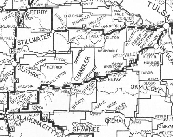
Chandler is in the middle, and Oklahoma City on the lower left side, on a secondary highway. The main road from Luther bypassed Arcadia and Edmond. The highway marked as "50" (in a black square) meaning the "Ozark Trails" would mostly become Route 66. You can follow it from Chandler to Oklahoma City.

1948 Shell Roadmap central Oklahoma
Click on map to enlarge
Source
See Route 66 in this 1948 roadmap (click thumbnail for full size map). At that time the Interstate system hadn't even been conceived. Chandler is on the upper right side of the map.
Route 66 from Chandler to Yukon
Starting point: Chandler
We will begin our itinerary on the eastern side of Chandler and drive westwards. There was only one alignment from 1926 to 1985 between Chandler, the next town: Warwick, and the eastern side of Wellston:
>> pale blue line in our custom map is the driveable US66 from Chandler to Wellston.
Ozark Trail
The local authorities of Lincoln county campaigned during the early 1910s for a branch of the Ozark Trail (OT) system to pass through Chandler and in 1916 they succeded, the OT passed through the town.
In 1924 it became Oklahoma State Highway No. 7 that ran from Miami to Oklahoma City. In 1916 it became Route 66.
But the OT followed a zig-zag course because it followed property lines, with plenty of right angle curves at the boundaries between properties. So when Route 66 was paved, it was also straightened out and shortened along its alignment.
In 1930 it was paved in Portland concrete eastwards from Creek County line into Chandler. Earlier, in 1928, the segment west of Chandler, to Warwick and Wellston had already been paved in asphalt.
1926-28 Through Chandler
The original Route 66 continued along Cleveland and then took a right along 4th. St. to Manvel. It crossed the railway on a bridge built in 1927. A new bridge replaced it along the current alignment in 1929, and this bridge was replaced in 1956 by the current one.
>> red line in our custom map is the 1926-28 Chandler alignment.
The central district of Chandler had been paved with bricks (Manvel Ave.) in 1926.
On the south side of the city Route 66 turns 90° and heads west to Warwick.

Warwick
Route 66 passed along the eastern and southern side of the town see this
>> pale blue line in our custom map is the driveable US66 from Chandler to Warwick.
It passed under the railroad on the SE side of the town. The tracks went along a trestle built in 1928, that remained in use until the roadway was widened in 1953.
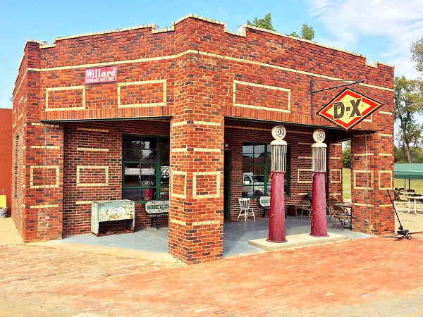
Seaba's filling station, Route 66 in Warwick, Oklahoma
Wellston
Route 66 runs straight west, and the Interstate now cuts US-66 on the eastern side of Wellston, pale blue line in our custom map. Then there is a fork and two alignments. Learn why are there two alignments of Route 66 at Wellston. Below is the story of a bypassed town:
The "Loop" and "Gap" of Route 66 in Wellston
The Loop
In 1926 when Route 66 was created it went right through Wellston following the state highway (now named OK-66B ) and Ash St. It "looped" north into the town and then again southwards, then it returned to its east-west course towards Luther.
A few months later, a vote was cast to issue bonds to pave the road through Wellston. By 1928, Route 66 was paved in asphalt from Chandler to Wellston's city limits, from there westwards, along the loop in and out of the town and onwards towards Luther it was a dirt surfaced road.
In 1930 the road west of the Lincoln - Oklahoma County line was paved in Portland concrete. The remaining section to be paved included Wellston, and here there two points of view collided: the town and state on one side, and the Federal government on the other.
The Gap
The U.S. Bureau of Public Roads favored an alignment that ran half a mile south of Wellston, and wanted to pave the short distance ("Gap") between the existing ("Loop") roadbeds that entered and exited Wellston, by simply building a road across the "gap", and save money in the process.
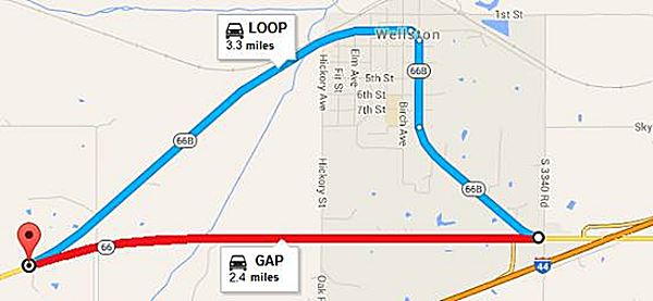
The town on the other hand realized that they would loose traffic and revenue if travelers took the shorter route and bypassed Wellston, so it lobbied for the "Loop" to be paved. The town took the case to court and won.
The Oklahoma Supreme Court ruled in its favor but the US Bureau of Public Roads stood by its decision to bypass Wellston and paved the "Gap" just the same.
However, the state Higway Commission had to abide by the court order and it paved the "Loop" through the town with Portland concrete in 1932, and built the Captain Creek bridge the following year. As it was not a U.S. highway, but a state higway, it was renamed as State Highway 66, becoming the first section of road to be named as a state highway "66" between Los Angeles and Chicago (many states would follow this practice fifty years later when US 66 was decomissioned).
Many years later, after U.S. Highway 66 was decertified and Route 66 became OK-66, this original "loop" through Wellston or State Highway OK-66 was renamed as OK-66B.
The federal Route 66 across the "Gap" was built in 1933 and also had its own bridges across Captain Creek, it was paved in Portland Concrete all the way to the Oklahoma county line.
The town's strategy failed: the loop did not manage to attract traffic through the town: in 1939 only 7 cars passed every hour through Wellston compared to 600 passing south of the town.
>> red line in our custom map is the "Gap" and blue line is the "Loop" in Wellston.
By the way, the Loop measures 3.3 miles and the Gap 2.4 miles, so it was less than one mile of road that kept Route 66 out of Wellston.
Historic Captain Creek Bridge
Listed in the National Register of Historic Places
The bridge was built in 1933 on the "Loop" through Wellston in the middle of the controversy over the alignment of Route 66. The steel bridge measures 225 ft long between abutments and the central span is 100 ft. long. The roadbed is 20 ft. wide.
It is a camelback pony truss bridge mounted on concrete piers and carries the "Loop" segment of Route 66 across Captain Creek.
Oklahoma state highway 66B heads southwest to meet OK-66 and heads west towards Luther.
Luther
Head west along OK-66 and when you reach Luther, there are several missing segments of the original roadbed (red and pink in our custom map).
>> pale blue line in our custom map is the driveable Wellston to Luther US 66.
The current highway curves slightly to the north on the eastern side of Luther because it was realigned in 1991 when the new railroad overpass was built. A short section of the original Route 66 survives in the town: one block of N. Dogwood St.
>> red line in our custom map is the 1926-1991 alignment in Luther, eliminated.
On the western side of the town, you can access a curved segment that heads eastwards to a dead end near Deep Fork River. This was the original 1926 road, paved in Portland cement in 1930 and bypassed in 1970 and the bridge removed:
>> pink line in our custom map is the 1926-70 alignment, only a part can be driven.
Arcadia
The highway continues west, to Arcadia and reaches the historic segment on the original alignment on the east side of the town.
>> pale blue line in our custom map is the Luther to Arcadia and west to I-35 driveable US66.
Historic Route 66 segment
Listed in the National Register of Historic Places
>> yellow line in our custom map is the historic 1926-52 Arcadia roadway.
It is an original segment of Route 66 built in 1926, paved in 1928 and 29, and part of the Mother Road until 1952, when it was bypased. There are two markers, one at each tip of the segment (pictured below).
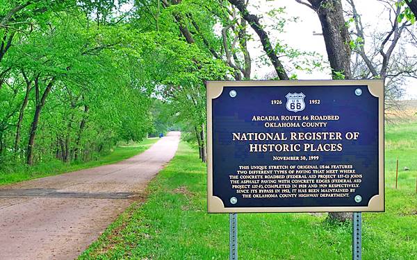
See this Map with directions.
It is an "S" shaped segment of road only 0.9 miles long (1.450 m), but it has a long history.
Historic section of Route 66 in Arcadia, where the paving types meet
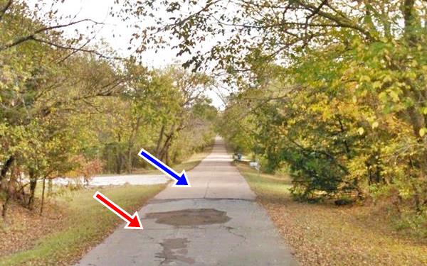
This part of the road is surrounded by local trees (oaks, cottonwood, cedar among others) and gives a glimpse of what travelers of bygone days experienced when driving along U.S. Highway 66.
It was paved between 1928 and 1929 and preserves to this day the two different paving technologies employed at the time.
- Eastern section: (Blue arrow) is the "first generation paving" (1928) which employed pure Portland Concrete with a Bates Type surface. It was a simple and cheap solution.
- Western section: (Red arrow) more advanced (1929) used a Modified Bates Type design. It had a two-inch thick asphalt surface paved on top of a 5 in. thick concrete base. It also had concrete edgings that were 9 inches wide. This type of paving required an on-site chemist and was more expensive. Similar to the US 66 section in Benld Illinois.
Both types of paving meet in the midpoint of this historic section and the original three-foot high marker of the Federal Aid Project describes both projects.
The road remained in use until the modern upgrade was built to the east, in 1952.
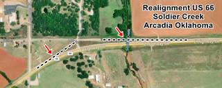
Soldier Creek realignment in Arcadia
At Soldier Creek (map showing the spot) the highway was improved and made safer in the 1950s: heading east, after North Anderson St. the original 1926 alignment continued straight with a SW-NE course, met 5th St. and turned sharply eastwards. Then it crossed Soldier Creek and met the current alignment 500 yards further east. This sharp curve was eliminated for a wider one, starting at the Washington Irving Campsite marker, and a new bridge built a few feet south of the old one. The original alignment can be seen in the dead end section of E 5th St. on the western side of the creek. You can spot the change in the tarmac at each end of this realignment.
>> blue line in our custom map is the Soldier Creek realignment in Arcadia.
Route 66 passes along the south side of Arcadia and heads west towards Edmond.
Edmond
The current State highway OK-66 follows the alignment of Route 66 from 1926 to 1954 between Arcadia and I-35 where the original alignment is cut by the Interstate (black line in map marks the gap):/p>
>> pale blue and black lines in our custom map is US 66 west of Arcadia.
This section of 3.1 miles was originally paved in brick, in 1927, between Douglas Blvd. (2.7 mi. west of the town) and Sooner Road (on the west side of the I-35 exchange).
From that point westwards until Fink Park (2.8 mi.) in Edmond the brick paving predated Route 66, as it had been laid in 1924. At that time the roadbed was part of the state highways OK-7 and OK-4.
From the Park and through Edmond all the way to Oklahoma City, the road had been paved in 1925 with local municipal funding.
The 1926 alignment took a left along Broadway (later US 77) towards Oklahoma City, and left it at Memorial Rd. to head south along Kelley all the way to Grand Blvd. (now I-44). map 1926-54 of Route 66 through Edmond.
>> violet line in our custom map is the 1926-54 alignment in Edmond
1954 realignment in Edmond
In Agust 1954 both highways US 66 and US 77 were moved from their alignment along Broadway and 2nd Street, to the new I-35 (known in those days as "Sooner Road"). where US 77 continued northbound and US 66 turned onto the expressway westwards.
From I-35 and 2nd St., both highways went along I-35 with a south-southwest course and met the brand-new Oklahoma City Northeast Expressway at the entrance to Turner Turnpike (modern Exchange 138). In those days there was no Killpatrick Turnpike running east to west.
The 1954 Route 66 kept south with both I-44 and I-35 in a southwesterly direction until reaching Grand Boulevard (Now I-44) where it turned right, towards the west, and reaching Kelley, it linked up with the old 1926 alignment again.
Map with directions 1954 realignment of Route 66 through Edmond into Oklahoma City.
>> green line in our custom map is the 1954 realigned US66.
Oklahoma City
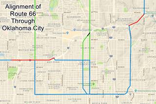
As with all other main cities along Route 66, the alignment in Oklahoma City changed many times between 1926 and 1985. We will describe them and include drivable maps and our custom interactive map too.
Map with the Pre-Interstate alignments in OKC
The color key to our image map showing Route 66's alignment through Oklahoma City is the following:
Pale Blue: Historic Route 66 alignments
Green: Beltline alignments.
Black: segment cut by the freeway.
Red: buried under the freeway.
Route 66 in Oklahoma City
U.S. 66 into OKC from the east
According to the Oklahoma DOT, these were the "official alignments of US 66 in Oklahoma City:
1926-54
From Kelley and Grand Blvd. (the boulevard is now buried by I-44 Route 66 kept westbound along the Blvd until reaching Beverly Dr. (in those days it was named
Lincoln Blvd.), where it turned left heading south towards the State Capitol building.
It was the main Route 66 alignment; it turned west on 23rd St. by the Sate Capitol
Map with directions
>> yellow line in our custom map is the 1926-54 US 66 into OKC.
1954-79 becomes City 66
The alingment was renamed City 66 because the Main 66 alignment had been realigned along modern I-44.
The different alignments of the original 66 and the later City 66 west of the State Capitol
1926-30
Along 23rd to Classen to 39th St. (Map with directions)
>> red line in our custom map is the 1926-30 US66 westwards along Classen.
1930-33
Along 23rd to Western to 39th St. (Map with directions). Met old alignment on 39th.
>>> blue line in our custom map is the 1930-33 US66 westwards along Western Ave.
1926-33
Westwards along 39th St. from N. Classen St. carried US 66 until 1933.
>> green line in our custom map is the 1926-33 US66 westwards along NW 39th.
1933-54
Continued west along 23rd to May Ave. turned north to 39th St. (Map with directions)
>> orange line in our custom map is the 1933-54 US66 westwards along May Ave.
1933-53
The alignment westwards from 23rd to to 39th St. and west to May Ave. became Alt 66
Alternate US 66 (Alt 66)
The American Association of State Highway and Transportation Officials (AASHTO) created the "Alternate" designation in 1959. Its purpose was to designate a route that branches off from the main highway, passes through given towns or cities and then connects again with the main numbered route. The idea is to accommodate a high traffic demand. When the Alternate and Main highways followed a similar course, the shorter and better built highway would be marked as main and the other as alternate.
There are only six places along Route 66 where an Alternate 66 alignment existed: From East to West they were the one into Chicago, Carthage MO, the one in Joplin MO, this one in Oklahoma City, Alt 66 in San Bernardino, California, and the one leading into Los Angeles CA.
1954-79
Route 66 along 23rd to May Ave. to 39th St. became Bus. 66 and the "City 66 was" eliminated. On 03.05.1979 US 66 Business Route deleted in Oklahoma City
Main US 66 west of Lincoln Ave and what now is I-44.
1954-76
West along Grand Blvd that was obliterated when it became the alignment of I-44, to Classen, to N.W. Expressway and NW 50th to what now is I-44 (Map with directions). At that time there was no freeway and NW Expressway here was a wide multi-lane avenue. See this 1954 aerial photograph of this segment.
>> bordeaux line in our custom map is the 1954-76 alignment.
1954-55
Temporary alignment along NW Expressway and N May while construction was underway along the 1955-76 alignment along 39th.
>> gray line in our custom map is the temporary 1954-55 US66.
1955-76
Followed what is now I-44 westwards from the N.W. Expressway along NW 39th all the way to May Ave. (Map with directions) it obliterated the previous alignments on 39th St.
>> brown line in our custom map is the 1955-76 Route 66.
1976-85
Route 66 was aligned along Modern I-44.
Map with directions
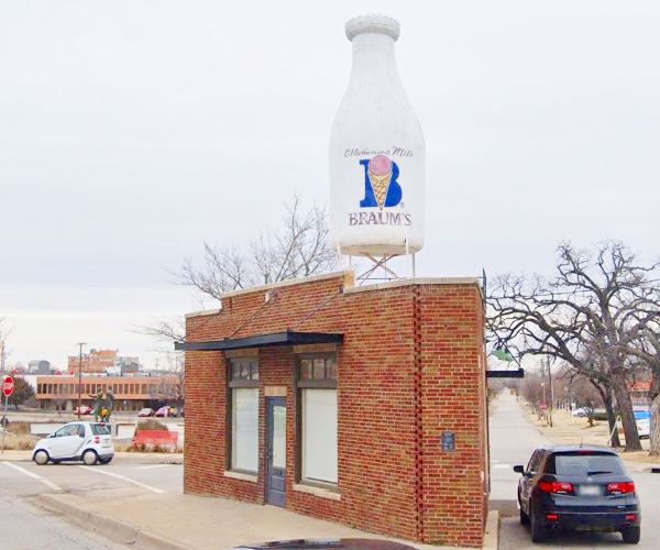
Beltline 66 alignments
We describe the attractions along the Beltline in our Oklahoma City Page 2.
The "Beltline" was in fact a bypass alignment around the city so that through traffic could avoid driving along the congested city streets.
There were different Beltline alignments over the years. They all split from the main alignment south of Edmond and met the City alignment again, on the NW side of OKC.
Coming from Edmond southbound along US 66 (N Kelly Ave), the "Beltline" split from the "City" US 66 on E. Britton Road, turning westwards along it and heading towards the town of Britton.
This was the route taken by Rittenhouse in 1946. Below are the three alignments that US 66 "Beltline" followed over the years.
1931-53 Beltline into Britton
The Beltline ran along E Britton Rd. into Britton 1931 to 1953 into Britton. The Beltline was eliminated in 1953.
>> red line in our custom map is the 1931-53 Beltline into Britton.
1931-36 Beltline South of Britton
Turned south in downtown Britton along Western Ave. all the way to 39th. (Map with directions)
>> light purple line in our custom map is the 1931-36 Beltline south of Britton.
1936-53 realigned Beltline
The southern tip of the previous Beltline changed, taking Classen towards 39th. (Map with directions)
Route 66 ran along N Western from 1931 until 1936. After that date it forked west, along Classen Blvd. to 39th Street where it met the City 66 alignment.
This area between N Western Ave. and I-44 in the north and Classen Blvd and NW 50th St. has changed considerably over the years; below we describe these changes.
>> pink line in our custom map is the 1936-53 Beltline realigned south of Britton.
The 1948 Shell roadmap below, shows N Western Ave on the right side, and, after crossing the Deep Fork River, Classen Blvd. branches off to the left with a NE-SW course, turning south again at NW 50th Street. Belle Isle Lake lies just west of it.
Three years later, the USGS map (1951) shows the new freeway under construction; it was the western extension of Grand Blvd. and it coincides with modern I-44 to the east of N Western Ave.
West of this point Route 66 continued along Classen to a circle or roundabout between 50th and 49ths Streets. There was no Northwest Expwy at that time and the land west of N. Georgia Ave was open countryside; and that is why I-44 was later built there.
This is a Map showing Classen Circle nowadays.

1948 Shell road map, Oklahoma City. David Rumsey

1951 USGS map, Oklahoma City
Then, in 1954 more changes were made.

1954 Aerial photograph Classen Circle, Oklahoma City. Source
The aerial photograph from 1954 shows more changes: the NW expressway has been built and meets the roundabout from the west, the freeway from the east has been finished and what is now I-44 is being built south of the NW expressway (from present Exit 125 B) up to Altadena Ave.
This would change later when Bell Island Lake was filled in and I-44 was completed between N. Western and Exit 125 B, running in an arch around former Classen Circle, acquiring its present configuration. The "Circle" no longer exists as a roundabout, though it remains in the street's name.
1947-53 Second Beltline
Continued west along Britton Rd. and then south on N May Ave., it was a second Beltline in addition to the older one it was deleted with the other Beltline in 1953 (Map with directions)
>> turquoise line in our custom map is the 1947-53 Second Beltline.

Bethany
The final part of the itinerary from Chandler to Yukon goes through the western side of Oklahoma City and Bethany. This is the 1926-85 alignment map with directions of Route 66 in Bethany and Western OKC.
>> teal line in our custom map is the Bethany US66 (1926-85).
Before Route 66, the road linking Yukon to Oklahoma City (OKC) was State Highway No. 3. It passed through Bethany and was paved in Portland concrete in 1923.
It ran from 39th and Penn in OKC Co. to the Lake Overholser Bridge. After US 66 was created in 1936, it was paved in Portland concrete to the Canadian County line (1926).
The highway was later upgraded to four lanes, as a divided highway.
This is the end of the itinerary, at Lake Overholser Bridge on the eastern side of Yukon.

Some sponsored content
>> Book your Hotel in Oklahoma City

Credits
Banner image: Hackberry General Store, Hackberry, California by Perla Eichenblat
Jack DeVere Rittenhouse, (1946). A Guide Book to Highway 66
Route 66 Maps. Oklahoma D.O.T.


