Your Route 66 Road Trip in Laquey
Index to this page
About Laquey Missouri
Facts, Trivia and useful information
Elevation: 1,080 ft (329 m). Population n⁄a (2010).
Time zone: Central (CST): UTC minus 6 hours. Summer (DST) CDT (UTC-5).
Laquey (pronounced "Lakeway") is a small unincorporated community located on the old 1926 alignment of US 66 in Pulaski County, in the Ozarks, South central Missouri.
Parsons’ store and post office in Laquey, Missouri
History of Laquey
For the general history of the area check the History of Waynesville.
Pulaski County was established in 1833, and was named after Kazimierz Pułaski, a Polish patriot who died fighting during the American Revolution War. West of Waynesville westwards towards Lebanon was the Osage Trail, along which Cyrus Parsons, a preacher from Maryland settled after the Civil War.
Parsons set up the Ideuma Baptist Church and a small community formed around it. Columbus Parsons opened a store in 1890 and in 1898 he and Joseph J. Laquey requested the U.S. Post Office to move the post office at Colley Hollow to their store. Thanks to Laquey's political contacts, the post office was moved and named after him: Laquey.
The post office moved out in 1983, but the small community is still alive.
The "Wire Road" built during the 1860s to service the telegraph line from St. Louis to Fort Smith in Arkansas, passed near Laquey, and would become the main road from St. Louis to Sprignfield. It carried traffic from Debruin, close to present Buckhorn, Laquey and then westwards through the now defunct settlements of Bellefonte, Flynn and Francis (which also had post offices at one time) it then crossed the county line passing through Hazelgreen and reaching Lebanon.
The name: Laquey
The original settlement at Idumea Baptist Church was named after the land of Edom, home of the ancestors of King Herod and was used because of the prophecy referring to Christ in Isaiah 63.
The town was named after Joseph John Alexander LaQuey (1848-1922), surname of probable French origin.
This road through town would become State Hwy. 16 in the early 1920s and U.S. 66 in 1926. However its alignment through Laquey was short lived. In the 1930s, the road was shortened and straightened out (eliminating 90° curves like that in "downtown" Laquey. The town was bypassed and remained dormant.

Find your accommodation close to Laquey
There are no hotels or motels in Laquey, but there are many options nearby in neighboring Waynesville or Lebanon.
> > Book your hotel in Waynesville
More Hotels near Laquey
There are several hotels in the area close to this town. Alternatively you can also find your accommodation along Route 66 in the neighboring towns and cities in Missouri. We list them below (from east to west):
On Route 66's Main alignment in MO
Eastwards
Westwards
- Hotels in Kansas
- Baxter Springs KS
- Galena KS
- Riverton KS
- Hotels in Oklahoma
- Miami OK
>> Check out the RV campground in neighboring Waynesville
Weather in Laquey

Location of Laquey on U.S. Hwy. 66
Laquey has well marked seasons: During summertime the average high (Jul) is 88°F (31.2°C), amd the average low is 67°F (19.2°C). During winter (Jan) the average high is 42°F (5.6°C) and the average low is below freezing at 20°F (-7°C).
Rainfall averages 44.5 in (1.131 mm) each year and falls regularly every month in roughly the same amount. Snowfall is around 9 in. (23 cm), and falls between Dec. and Mar.
Tornado risk
Laquey is located within the infamous "Tornado Alley"; Pulasky County gets around 8 tornado strikes yearly.
Tornado Risk: learn more about the Tornado Risk on Route66.
Map of Route 66 in Laquey MO
U.S. 66 Alignment and maps in Laquey
Laquey is located on the 1926 to 1930 alingment of Route 66 and was bypassed after 1930.
From Buckhorn in the east, the original alignment curved through Laquey as shown in this map.
After 1930, when the road was paved it was straightened out to make it shorter, Laquey was bypassed by what is now County Road AB in the 1930s. This is shown in
this map of US66 in Laquey.
The thumbnail image shows a map by the USGS published in 1943; notice the old alignment through Laquey (red and white dashed line top and left) and Route 66 after 1930, as a solid red line (right and bottom) curving around Laquey. After 1952 this alignment was bypassed by the 4-lane highway.
The Route 66 alignment in Laquey
Visit our pages, with old maps and plenty of information about US 66's alignments.
- Springfield to Joplin (next)
- Rolla to Springfield (Laquey's)
- Gray Summit to Rolla (previous)
Route 66 Sights in Laquey
Laquey and its Route 66 attractions
Historic context, the classic Route 66 in Laquey
Jack DeVere Rittenhouse published his "A Guide Book to Highway 66" in 1946 and in it gives us a good description of the Mother Road in those days. Of course he did not mention the town because it was located on a previous (1926-30) alignment of U.S. 66. Instead he does mention Buckhorn to the east and Gascozark to the west. Regarding the area around Laquey, he says "You are now in the MARK TWAIN NATIONAL FOREST, and entering one of the most beautiful sections of the Ozarks".
Mark Twain National Forest
This U.S. National Forest was established in 1939, and here, is located to the south of Route 66 between Rolla and Gascozark, including Fort Leonard Wood. It was named after Mark Twain, a Missouri native.
Tour through Laquey

Vintage photo of Parsons Store in Laquey on Route 66. Source
You will tour the village from east to west, coming from Buckhorn and heading through Laquey towards Gascozark.
The starting point is County Road P and Old Route 66 (County Road AB), coming from Waynesville and I-44, to the east of Laquey, it is the point where the 1926 to 1930 alignment splits off to the right frmo the newer (1930-50s) Route 66 alignment that heads straight.
Turn right along the original Route 66 and roughly 0.8 mi. ahead is the Old Parsons' Store and Post Office.
Parson's Store
To your left, at Co. Rd. P and Co. Rd. AA. This building dates back to 1890. It was built by Columbus Parsons, who in 1898 petitioned to have the post office moved here.
The old black and white image shows us what the place looked like during the 1960s. At that time it was "Laquey Market", notice the Post Office sign with the zip code (this means the photo was taken between 1963 and 1983 - creation date of zip codes and the closure date of the post office).
Head west a and take a left at County Road AA southwards. Just ahead along Sherwood Lane, to your left is the old Cemetery and Idumea Church established in 1872 by Cyrus Parsons.
The itinerary ends when you reach County Road AB again, which is the Route 66 alignment after 1930, there are two landmarks along this roadway.
The 1930-53 Route 66 Alignment
Roadside Park
Rittenhouse wrote that what is now Buckhorn was located 5 miles west of Waynesville ("a small community here") he added that two miles west "are some roadside picnic tables (L) among the trees" (the "L" stands for left). This "Roadside Park" appears in the 1943 USGS map of the area, on the eastern side of the highway.
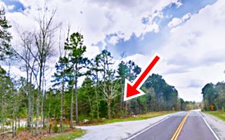
The spot can be seen in a 1955 aerial photo, on the right side of the photo. See the image below showing the spot nowadays (red arrow), the tables are gone.

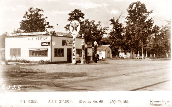
Riggs Texaco, US66 Laquey. Source
A&E Riggs Texaco station
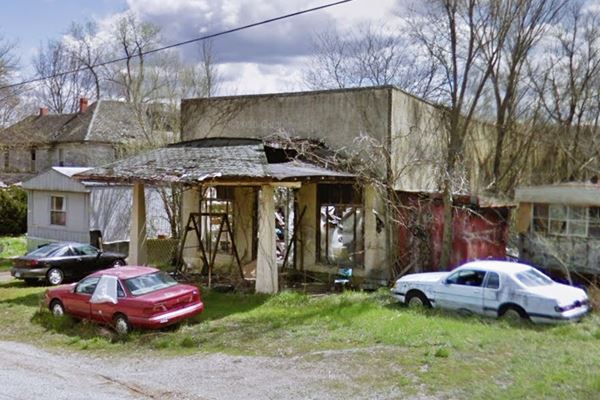
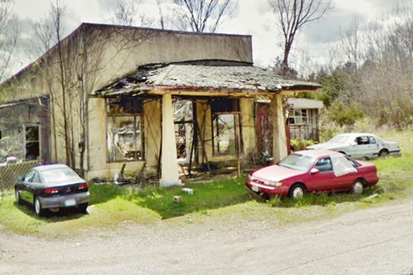
Drive westwards, and after one mile, as you reach the junction with MO-17, there is a small community with some homes, and the site of a gas station mentioned by Rittenhouse (pictured above). This aerial photo shows the site in 1955.
It was R.E. Riggs Texaco, known as A&E station, and it had some cabins. It is on the south side of the highway to your left. Below is a "Then and Now" sequence; the eastern part (to the left) of the building is the old station.
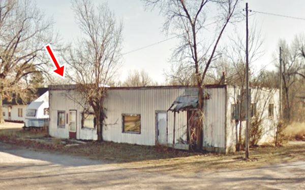
Just ahead is the junction with Co. Rd. AA, that comes from the north (right), from Laquey. It is the 1926-30 Route 66 alignment.
This is the end of your Route 66 tour through Laquey; head west and continue your road trip visiting Gascozark.

Some sponsored content
> > Book your Hotel in Lebanon

Credits
Banner image: Hackberry General Store, Hackberry, Arizona by Perla Eichenblat
Jack DeVere Rittenhouse, (1946). A Guide Book to Highway 66


