Lebanon on Route 66
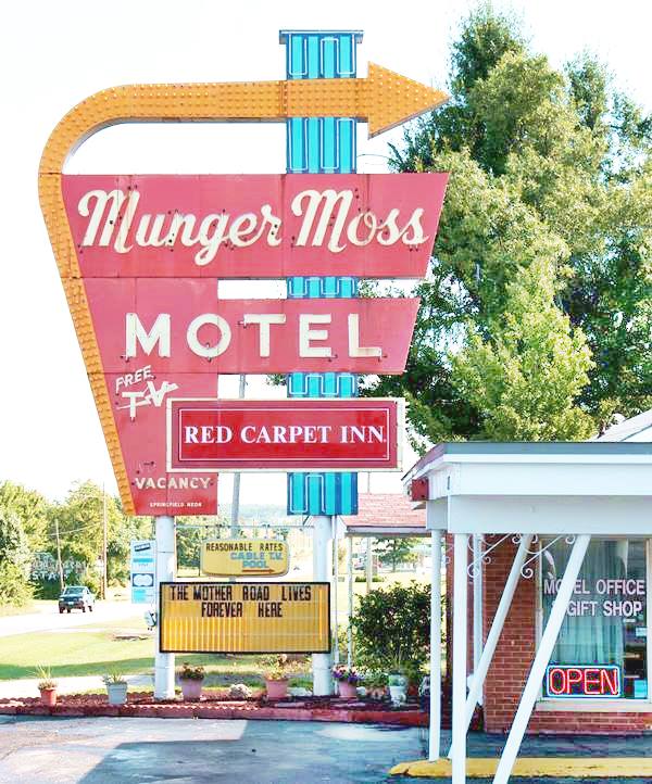
Munger Moss Motel Neon Sign, Lebanon MO
Index to this page
About Lebanon Missouri
Facts, Trivia and useful information
Elevation: 1,265 ft (386 m). Population 14,474 (2010).
Time zone: Central (CST): UTC minus 6 hours. Summer (DST) CDT (UTC-5). Lebanon is the seat of Laclede County, in south central Missouri.
History of Lebanon
South-central Missouri has been inhabited for some 10,000 years, since the end of the last Ice Age. Around 700 BC the native Osage people were expelled from their land in the Ohio and Mississippi rivers by the Iroquois and settled here they established a village called Wyota (which meant "ever flowing spring").
In 1682 French explorers from Canada claimed the area naming it "Louisiana" after their king Louis XIV. In 1803, the French sold it to the U.S., it became the Missouri Territory in 1812 and a state in 1821.
During that period, white settlers began moving westwards and native living east of the Mississippi as well as the Ossage were forced to relinquish their territories to the
government and were finally relocated in reservations in what is now Oklahoma.
Jesse Ballew was the first settler, in 1820 he built his home on the Gasconade River. The land was surveyed during the 1840s and in 1849, the Harrison and Appling families
donated 50 acres of land towards the establishment of the county seat for the newly created Laclede County. It was originally named Wyota.
By 1851 courthouse and jail were already built and the post office opened in 1853. The new town saw the telegraph line built through it during the Civil War and was occupied by Union troops and the "Wire Road" was built next to the telegraph line from St. Louis MO to Fort Smith, Arkansas. The Frisco railway reached the town in 1868 but built the station one mile away from the downtown, south of it. This led to a shift in business from the "Old" to the "New" town. The town became a city in 1877.
The name: Lebanon
In the 1850s it adopted the name Lebanon, after the hometown of one of the town's outstanding citizens, Rev. Benjamin Hooke, Lebanon Tennessee. Which in turn got its name from the abundance of Eastern Red Cedar trees in the area (Lebanon, the country, is renowned for its cedars).
Magnetic Water
In 1889 a worker digging a water will noticed that his tools attracted nails. They had been magnetized by the water. This led to the creation of a spa. The magnetic water was said to be good for the health, it was used in baths and bottled for drinking. The Gasconade Hotel which could house 500 guests was built to cope with the inflow of travellers. It burned down 10 years later.
The "Wire Road" became the main road from St. Louis to Sprignfield and would become State Hwy. 16 in the early 1920s and U.S. 66 in 1926. Route 66 passed through the town until 1957, when it became a four-lane freeway bypassing it.

Weclome arch, Lebanon MO.
Getting to Lebanon
At one time two arches spanned Route 66 with the words "LEBANON - Drive In - Our Town Your Town" at both the western and eastern ends of town, and not only on Route 66, the image shows one probably SW of the city on MO-32.
You can reach Lebanon along historic Route 66 and Interstate I-44 that links it with Springfield, Tulsa and Oklahoma City in the west and with Cuba and St. Louis in the east. US 160, 60 and 65 run to the west, through Springfield, US 63 runs through Rolla, to the east.

Where to Lodge in Lebanon, Missouri
Accommodation in town, find your hotel or motel in Lebanon or in other nearby towns along Route 66.
> > Book your hotel in Lebanon
More Lodging near Lebanon along Route 66
There are several hotels in the area close to this town. Alternatively you can also find your accommodation along Route 66 in the neighboring towns and cities in Missouri. We list them below (from east to west):
On Route 66's Main alignment in MO
Eastwards
Westwards
- Hotels in Kansas
- Baxter Springs KS
- Galena KS
- Riverton KS
- Hotels in Oklahoma
- Miami OK
>> Check out the RV campground in Lebanon
Weather in Lebanon

Location of Lebanon on U.S. Hwy. 66
Lebanon has well defined seasons: The summer (Jul) average high is 88°F (31.2°C) and the average low is 67°F (19.2°C). The winter (Jan) average high is 42°F (5.6°C) with a below freezing average low of 21°F (-6°C). Rainfall averages 45.3 in (1151 mm) yeary fairly stable across the year (ranging from 2 in monthly, -50 mm in Jan and Feb, to 5,67 in. in May. -144 mm). Snowfall is around 9 in. (23 cm), and falls between Dec. and Mar.
Tornado risk
Lebanon is located in the "Tornado Alley" and Laclede County is hit by some 8 tornado strikes every year. Tornado Risk: read more about Tornado Risk along Route66.
Map of Route 66 in Lebanon, MO
Check out Lebanon on our Missouri Route 66 Map, with the complete alignment and all the towns along it.
Map with the alignment of Route 66 through Lebanon
See this US 66 alignment in Lebanon, it shows the classic historic 1926 to 1957 alignment of Route 66. The highway after 1957 became part of what is now I-44. Historic U.S. highway 66, "Route 66" has been designated as an All-American Road and National Scenic Byway in the state of Missouri.
The Shell roadmap published in 1958 shows us that in Lebanon, US 66 was a regular 2-lane highway, however, it was a "super-highway" with 4 or more lanes from Stratford to Conway and from Hazelgreen through Waynesville.
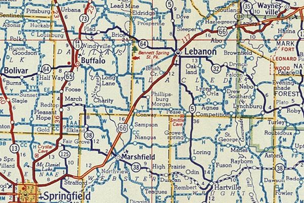
The Route 66 alignment in Lebanon
Visit our pages, with old maps and plenty of information about US 66's alignments.
- Springfield to Joplin (next)
- Rolla to Springfield (Lebanon's)
- Gray Summit to Rolla (previous)
Route 66 Sights in Lebanon
Lebanon is the "Aluminum Fishing Boat Capital of the World"
- City Tour of Lebanon - read on below
- Parks and outdoors
Governor Kit Bond named Lebanon "Aluminum Fishing Boat Capital of the World" back in 1983 because of the large number of boatS and canoe manufacturers in town.
Historic context, the classic Route 66 in Lebanon
Jack DeVere Rittenhouse published his "A Guide Book to Highway 66" in 1946 and he mentioned the town as follows:
Lebanon... garages; hotels: Harris, Laclede, Nelson; courts: Camp Joy, Nelson Dream Village, Clark's Rock Court, Green Gables; all facilities.) US 66 skirts the eastern edge of the town, which is the major community on US 66 between Rolla and Springfield. Rittenhouse (1946)
He added the attractions of this area, known as the "Ozarks Playground", with "More than 100 varieties of trees... rolling hills... swift streams". East of Lebanon he mentioned the following places (distance in miles): "Vesta Court; gas" (4 mi), "Gas and Cabins" (8 mi), "gas" (9 mi), "Lucy's Cabins" (12 mi.) and "Cabins and gas" (13 mi). None of them have survived.
Our City Tour with Route 66 landmarks in Lebanon
Begin your tour at the town's easternmost access, 5 miles east of Lebanon, at I-44's Exit 135. This is where the freeway cuts across old Route 66, which here passes fromt he eastern side to the western side of the interstate, becoming Pecos Drive

Old Route 66 Satellite Cafe Sign. Source
Click for Street View
Former Mr C’s
24200 Rte 66, Lebanon. To your left (Street View). Once famous for its signs marking the mileage to different cities around the globe (Helsinki, Rio de Janeiro).
It closed after the death of its owner and was a soda plant (Route 66 sodas), gift shop and now is an Elks Lodge.
Satellite Cafe Neon Sign
24001 Old Route 66, just 0.4 mi. west of the Elks Lodge, to your right just past the I-44 Speedway. It is a rusting yellow sign with the words "Cafe - Fried Chicken - Home Made Pie."
The white rocket close to the sign is part of the Satellite Cafe and Phillips 66 Space Station; it opened in 1965 and burned down in 1999. You can see the original counter and café stools at Lebanon's Route 66 Museum.
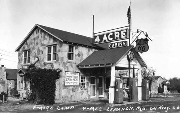
Four Acre Court
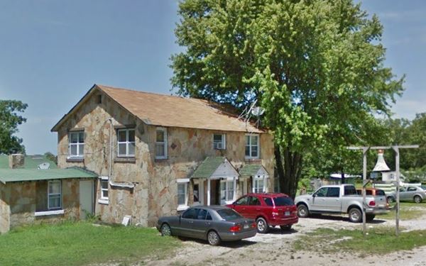
Just 0.9 mi. ahead, at 23442 Old Route 66 (Pecos Dr.), to your right. This is a classic stone building with the original sandstone cabins behind it. Coleman and Waters opened it in 1949. Later it was known as "Village Oaks" and it stands relatively untouched as you can see in the "Then and Now" images below.
The old Four Acre Court postcard.
Vesta Court site
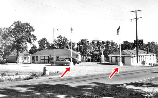
300 feet west you will see, to your right, the site of the former Vesta Court, it had a Texaco station, several cabins lined parallel to Route 66, an eastern and western access which had an arch over them.
It opened in 1937, and in 1946 Rittenhouse mentioned it ("Vesta court; gas."). In 1957 Mary and Bill Williams renamed it "EL Rancho Court".
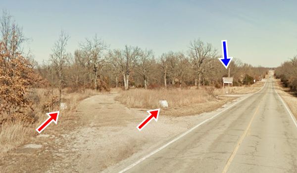
The remains of the cafe's foundations are still visible (Satellite view).
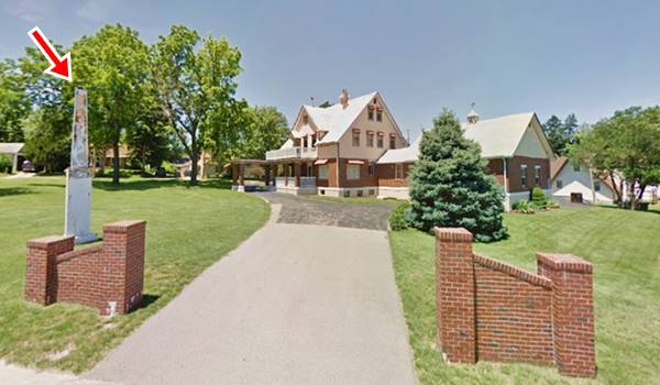
and the base of the western entrance arch too (red arrow in photos) and the rusty sign (blue arrow)
Postcard of Vesta Court ca.1950
Site of Vesta Court as it is today
Munger Moss Motel
Drive west along Route 66 for 2.7 miles to reach the eastern side of Lebanon. Here, to your left is the classic Munger Moss Motel (1336 East Rte 66).
Nellie Draper Munger and her second husband Emmett A. Moss built the Old Munger-Moss Café and Sandwich Shop in Devil's Elbow in 1936. But when it was bypassed by a new four-lane US66 in 1942,
they sold it and moved to Lebanon where they opened a filling station and restaurant in 1945 and added the motel in 1946. It is still open.
Munger Moss Neon Sign - Classic Route 66 Sight
The neon sign (pictured at the top of this page and also above) is a typical Route 66 eye catcher. It was restored with a grant from the The Neon Heritage Preservation Committee, The Route 66 Association of Missouri and The National Park Service helped in 2010.
Starlite Lanes
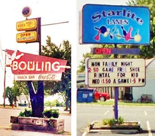
Across Route 66, right in front of Munger Moss, to your right is this classic bowling alley, take a peek at their neon sign, it has changed as you can see in the photos. Now more sedate.
Route 66 Shields on the tarmac
Don't miss the two Route 66 shields painted on the highway right there between Munger Moss and Satellite Lanes (See photo further up).
Ahead, to your right is another classic motel, after the bowling lanes.
Forest Manor Motel and Campground
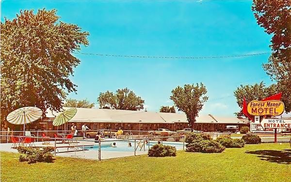
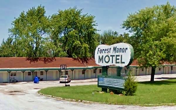
1307 Rte 66, to your right. This tourist camp began as "Green Gables Court" in 1941, owned by Elsie and Lee Kimes. It had individual cabins with car ports between them.
Later it became Forest Manor which is still open and operating as a motel and RV Park: Forest Manor Motel & RV Park
The postcard below announced: "Reasonable Rates... T.V., air conditioning, Restaurant, Coin Laundry... clean, pleasant campground. Jim & Aria Pape Owners". The "Now and Then" images show that the pool has gone and the sign has changed and lost part of its classic charm.
Forest Manor Motel and Campground nowadays
Across the street, next to Munger Moss' southern side, once stood the "Rock Court Motel". It was torn down.
Wrink's Food Market
Keep westbound, and just ahead, to your right is Wrink's Food Market, and to its right was the "Holiday Motel" which has been torn down. At 135 Wrinkle Ave. and Route 66. The red-brick store was built between 1946 and 1950 by G.E. Wrinkle, a local entrepreneur who owned the Jefferson Hotel and Cafe.
He planned to open a hotel there but after falling ill only completing the first floor, his son Glenn used it for his store "Wrink's Market". After his passing in 2007, G.E.'s grandson, Terry runs the place.
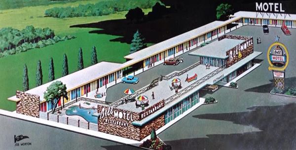
Bell Motel
At Milcreek Rd., take a right and head into town. Ahead to your right are the remains of "Bell Motel".
Clinton and Jim Bell had come to Lebanon in 1946 and built the Bell Restaurant on the site. It closed around 2011. The motel's eastern wing with the pool has been torn down except for some rooms on the back of the premises, which have conserved the original brickwork on S. Crescent Dr. (red arrow). The western wing (blue arrow) is now the "Budget Inn" motel.
The central part of the premises are occupied by a gas station (which formed part of the complex). It has a mansard roof shingled canopy typical of the late 1960s.
Old Conoco station
Across from Bell Motel, to your right, is a vintage gas station. It looks like a Conoco as they favored V-shaped double steel posts for their signs. It is a 1950's oblong box design with no canopy, two garage bays, and no canopy. Now it is an auto repair shop. Pictured below.

White Buffalo statue. Click for Street View. Source
White Buffalo statue
Across from the Conoco is JR's Western Store, a shop that sells a selection of boots and western apparel. Don't miss the life-sized white buffalo that stands in front of the store. It is pictured above.
Mobil Service Station
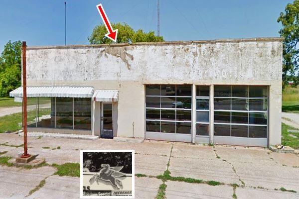
Ahead, following the Conoco, at 801 Rte. 66, to your right, is an old ice-box style service station ca. 1940s with a two-bay garage and an large window office.
The Ghost Pegassus where Mobil's logo, they flying horse once stood is clearly visible above the entrance door (red arrow).
Street view of The Old Mobil Gas Station, notice the "ghost" image of the flying horse in the central part of the parapet (the black and white inset shows what it would have looked like).
Lenz HoMoTel
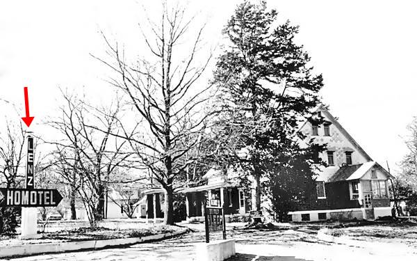
Keep west along Route 66, and at the NW corner of Sherman Ave. is the former "Lenz HoMoTel", At 302 Sherman Ave. William. Otto Lenz and his wife took opened it in 1932, after reconverting their 14-room home built in 190s into a "home - hotel" (hence its name), offering the comforts
of home in a hotel. Now it is a bed and breakfast "Manor House Inn".
In the "Then and Now" sequence below you will notice the old columns at the entrance, (red arrows) at one time they sported signs "LENZ - HOMOTEL".
Orchard Hills - former Phillips 66 Service Station
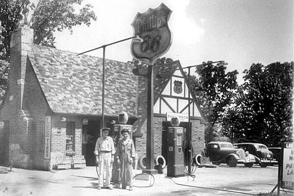
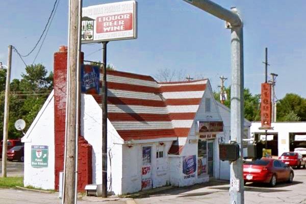
You are now approaching the downtown district. To your right is an iconic Service Station, on the NW corner of E Elm St. (Route 66) and Washington Ave.
Built in 1935 by O.E. Carter and E. Lawson in the classic "cottage style", favored in those days because the gas stations blended in with their surrounding residential area.
Originally it sold Barnsdall "B-square to your motor" gasoline. This brand later became the Bareco Oil Company in 1940. By then Carter and Lawson had switched to
Phillips 66 brand. It remaind open until 1971. Now it is the Orchard Hills Liquor Store. The then and now sequence shows us that the place is almost the same.
1930s picture of the cottage style Phillips 66 gas station
Woods DX Gas station
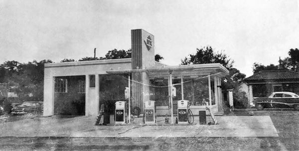
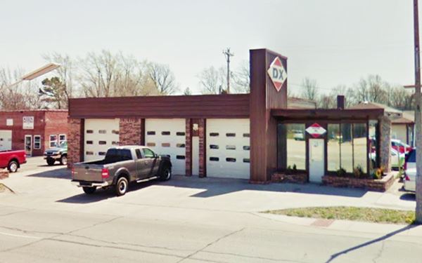
Keep west one block, and to your left (637 S. Adams and US 66) is an auto dealer that at one time was a DX Gas station, Woods station. With three garage bays, corner office with plate glass windows and a vertical pylon separating both areas. On the pylon, the DX logo. The photo below from the 1950s shows that at that time it only had two garage bays.
Historic Old Jail
Listed in the National Register of Historic Places
At the corner, take a right along Adams Ave. and drive six blocks west, to see the historic Jail, on the NE corner of N. Adams Ave. and E 3rd St. Street view, it was built in 1876 and is probably the oldest building in town. It housed inmates until 1955, when they were relocated in the current jail, behind it. Now it is a museum.
Go along E 3rd St. one block south to S Jefferson Ave, take a right to return to Route 66. Visit an icon from the 1960s Swiss Inn.
Mr. Swiss
356 N Jefferson Ave. This A-frame building which is now known as Swiss Inn, opened in 1967 as part of the "Mr. Swiss" hamburger drive-in owned by L. Doefler who started it in 1964 in Oklahoma City, OK selling hamburgers, ice cream and sandwiches. It eventually had 200 stores across the US, and closed 1970s. There is another one on US 66 in Joplin MO and also in Claremore OK and in Oklahoma City, OK. The "V" shaped sign post is the original one.
Anthony's Station
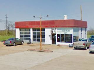
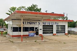
Head back eastwards towards US 66, cross it and to your right on the NE corner is a 1950-60 gas station. Now it is Anthony's Auto Clinic, it has two multi-window garage bays, a flat canopy with one pump island and a white enamel finish. Pictured above.
Route 66 Museum
Head straight for 0.4 miles to visit the Route 66 Museum at 915 S. Jefferson Ave.
It has photos, memorabilia, and full scale models that re-create a 1940s tourist cabin, a gas station from the 1930s, and a 1950s diner. Located in the County Library (Street View).
North Star Cafe
Retrace your steps back to Route 66 and turn left to head west along it. After two and a half blocks, to your right is a former Café.
Now a Tax and Accounting office at 314 W Elm St., it opened in 1959, as a Café with "Good Food Reasonable Prices". The gable roof building is still standing.

Former North Star Café. Source
Mobil Station
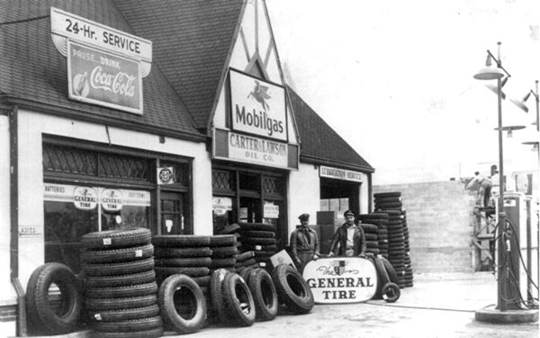
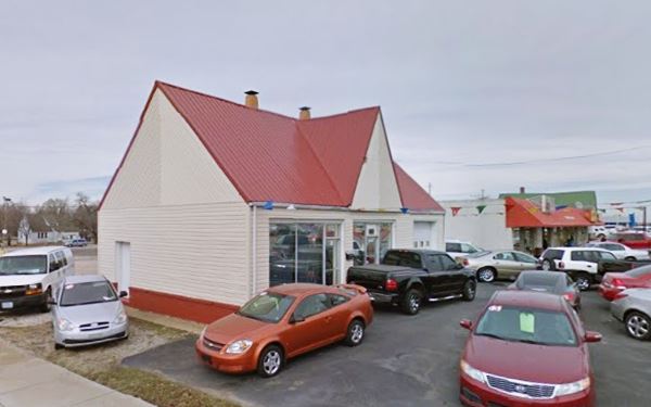
On the next corner, to your right (398 W Elm St NW Corner) is another steep gabled cottage-style gas station. It was owned by Carter and Lawson and dates back to the 1930s when it was a Mobil station. It used to have a flat roofed canopy over two pumps facing Route 66. Now it is an auto dealership.
The road heads out of the downtown area, and curves south. Just past Fowler Rd., to your right is former Red Fox Motel:
Wallick Buick Dealership
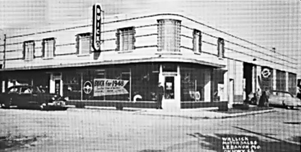
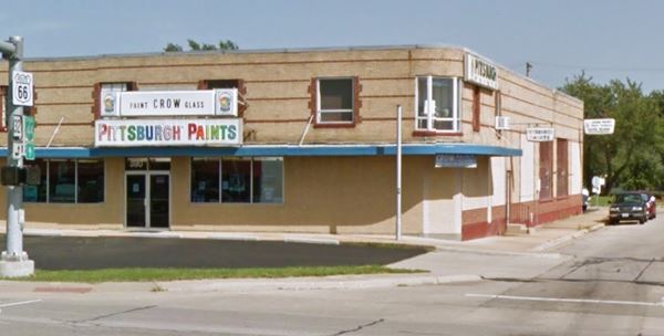
Facing it, across US 66 is a former Buick dealership. It opened after WWII and was owned by Harve V. Wallick. The building is still standing and in pretty good shape. Now it sells glass and paint. Below is a "Then and Now" sequence.
Red Fox Motel
Drive west along US 66 (Elm St.) for 1.1 miles, it curves southwards. At 1405 W Elm St, to your left you will spot the old Red Fox Motel -now closed. It had 12 units. Later it became the Clover Leaf, whose postcard announced: "1⁄2 mile west of the city on Highway Route 66 Twelve fully modern units, equipped with fine Mengel furniture and Englander Super Hotel Mattresses Automatic panel ray heat with thermostat control Ceramic tiled showers Air cooled, fully insulated Reasonable...".
White Sands Motel
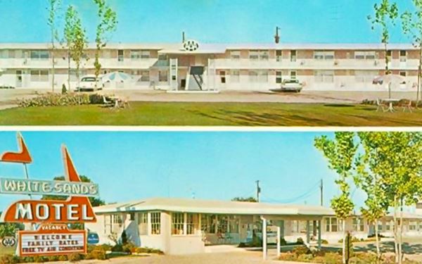
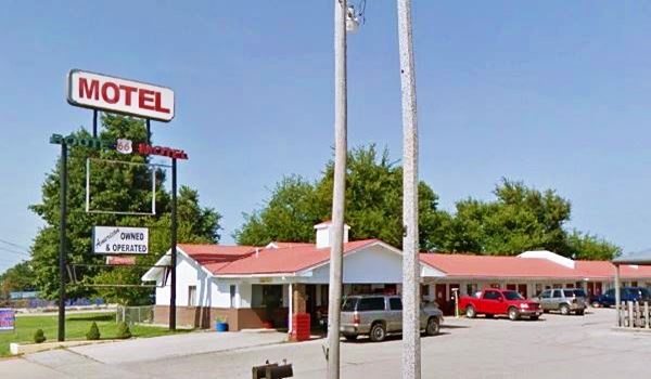
Keep west for 0.4 mi, and passing Durham Rd., on your left is the former White Sands Motel at 1710 W Elm St, Lebanon. It is still open, but now it is the Historic Route 66 Inn, its postcard from the 1960s said: "31 Rooms, Air Conditioned, Free TV, Wall to Wall Carpets, Panel Ray Heat, Tub and Shower... Lilards, Owners and Managers". The front court which was open and had a lawn, now has a barbecue restaurant (Dowd's Catfish and BBQ). But the motel is quite unchanged (the old sign has of course been replaced by a more "modern" and duller one).
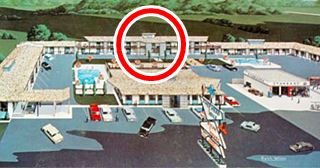
Shepherd Hills Motel and Restaurant
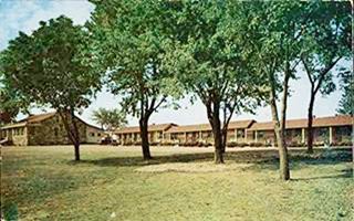
Just ahead, to your left (1830 West Elm Street). This motel is still open, now as the Americas Best Value Inn. The postcard below stated "Interstate 44 City Rt 66 West Color TV and AM-FM radios telephones in every room heated swimming pool children's playground family rates restaurant seats 250 two dining rooms banquet rooma and coffee shop beauty shop barber shop and gift shop".
Of the old "U" shaped motel only the eastern and northern "L" remains. The former large space in the middle is now Headley's Value Tire Center and Eagle Stop. The red circle in the postcard shows the area which is pictured in the "now" version below.
A "now" and "then" view of the Shepherd Hills Motel, today Americas Best Value Inn.
Your city tour of Route 66 in Lebanon ends here.
Outdoors, National and State Parks
Bennett Spring State Park
11 mi. west of town via Highway 64, Map with directions. Created in 1923, it receives one million visitors yearly, and has hiking trails, the Savanna Ridge and the Natural Tunnel. Read more at their official website.
Some sponsored content
> > Book your Hotel in Lebanon

Credits
Banner image: Hackberry General Store, Hackberry, Arizona by Perla Eichenblat
The Ramsay Place Names File
Maura Johnson and John F. Bradbury, Route 66 Association of Missouri. 1993, Architectural ⁄ Historical Inventory Survey. Route 66 in Missouri
Jack DeVere Rittenhouse, (1946). A Guide Book to Highway 66.


