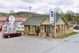
Your Route 66 Road Trip in Waynesville
Index to this page
- About Waynesville
- Weather
- Hotels close to Waynesville
- Map of US 66
- What to see and do in Waynesville
About Waynesville Missouri
Facts, Trivia and useful information
Elevation: 807 ft (246 m). Population 5,463 (2024).
Time zone: Central (CST): UTC minus 6 hours. Summer (DST) CDT (UTC-5).
Waynesville is Pulaski county seat, and is located ont the old U.S. 66 South central Missouri's Ozarks.
History of Waynesville
This part of Central Missouri has been inhabited for over 10,000 years, since the end of the last Ice Age. Its Native people, the Osage reached the region ca. 700 BC after being expelled by the Iroquois from their original territory along the Ohio and Mississippi rivers.
The French, explored the area in the 1680s, and annexed it as "Louisiana", named so after King Louis XIV. In 1803, a cash-strapped Napoleon Bonaparte, sold it to the U.S. for 15 million dollars. It was subdivided into territories and one of them became the state of Missouri in 1821.
There was a mill at Roubidoux Creek and a settlement grew up next to it in 1826. It moved in 1831 to G. W. Gibson's homestead at the old Osage Trail which became the first county seat in 1833. The town was platted in 1834 on 25 acres of land donated by William Moore and Josiah Christeson, it was named after its post office (which opened that same year).
The name: Waynesville
Named after American Revolution War general Anthony "Mad Anthony" Wayne (1746-1796) plus the suffix "ville". The surname was an occupational name for a driver or builder of a "wain" or waggon. It comes derivation is from Old English "Waegn" - "Waegen" which meant cart, wagon.
Trail of Tears
By the 1820s more natives had been resettled by the U.S. Government in Missouri (like the Delaware and the Kickapoo) from their lands east
of the Mississippi. It was a policy to clear the native people from the land east of the great river.
In 1832, the Osage were also forced to relinquish their territory and were later relocated in Texas, Kansas and Oklahoma.
After a treaty imposedon them by the U.S. government, in 1839 the Cherokee Tribe was also forcibly uprooted and relocated in Oklahoma.
Their march is known as the "Trail of Tears" during which thousands of natives perished. Route 66 follows the ancient trail used by the Cherokee nation.
Read more below, at Laughling Park, Trail of Tears Memorial site.
The town grows
The "Wire Road" built during the 1860s to service the telegraph line from St. Louis to Fort Smith in Arkansas, passed through Waynesville, and would become the main road from St. Louis to Springfield, and the stagecoach served the town three times a week.
It was captured by the Union troops of Col. F. Siegel in 1862 who built a Fort here. In the 1870s, the railway bypassed it so it grew slowly.
The late 1800s and early 1900s county maps show Waynesville linked to Lebanon via Laquey and to the St. Louis and San Francisco Railroad to the north at Crocker. There was a trail east towards Ford (now defunct) and Hooker which was linked to Arlington and Jerome.
These trails, part of the Old Wire Road became State Hwy. 14 in the early 1920s and U.S. 66 in 1926. It was paved in 1931 and traffic through the town surged.
Neighboring Fort Leonard Wood gave the town's economy a boost during World War II. Later during the 1950s, Route 66 was completely upgraded to a four-lane freeway and its alignment
straightened out, bypasseing the town.

Getting to Waynesville
Drive to Waynesville along historic Route 66 and Interstate I-44 that links it with Springfield, Carthage, Joplin and Oklahoma City in the west and with Rolla, Cuba and St. Louis to the east.
Find your accommodation in Waynesville
There are plenty of options to find your hotel or motel in town. Book your room in Waynesville.
> > Book your hotel in Waynesville
More Hotels close to Waynesvilley
There are several hotels in the area close to this town. Alternatively you can also find your accommodation along Route 66 in the neighboring towns and cities in Missouri. We list them below (from east to west):
On Route 66's Main alignment in MO
Eastwards
Westwards
- Hotels in Kansas
- Baxter Springs KS
- Galena KS
- Riverton KS
- Hotels in Oklahoma
- Miami OK
>> Check out the RV campground in Waynesville
The Weather in Waynesville

Location of Waynesville on U.S. Hwy. 66
Waynesville has well defined seasons. The average temperatures are the following summer (Jul) avg. high 88°F (31.2°C) and avg. low around 67°F (19.2°C). In winter (Jan) the averages are: high 42°F (5.6°C) and the low is a chilly-below freezing 20°F (-7°C).
Rainfall is around 44.5 in (1.131 mm) yearly average, at a contstant rate each month. About 9 in. (23 cm), of snow falls from Dec. to Mar.
Tornado risk
Waynesville is within the "Tornado Alley" and Pulaski County is hit by some 8 tornados every year.
Tornado Risk: read more about Tornado Risk along Route66.
Map of Route 66 in Waynesville
Waynesville U.S. 66 alignment
From St. Robert trough Waynesville Route 66 was a regular two-lane road from 1926 (paved in 1931), and well into the 1950s. Then traffic boomed and a safer and straighter highway was needed. The four-lane "super-highway" was extended westwards from St. Robert towards Lebanon.
The original 1926-50s alignment is shown in this map, through the town, and west towards Buckhorn.
In the early 1950s, the four-lane alignment was built around the city, bypassing Waynesville and following what is now I-44. The original Route 66 present MO-17 was renamed in the '50s "Highway T".
The Route 66 alignment in Waynesville
Visit our pages, with old maps and plenty of information about US 66's alignments.
- Springfield to Joplin (next)
- Rolla to Springfield (Waynesville's)
- Gray Summit to Rolla (previous)
Route 66 - Birthplace of the Byway
Missouri was the first state to assign historic status to U.S. Highway 66. On July 10, 1990 the bill was signed by Gov. John Ahscroft at Pulaski county's Courthouse, here in Waynesville.
What to see in Waynesville: Route 66 Sights and attractions
Landmarks and Classic sights in town
Historic context, the classic Route 66 in Waynesville
In 1946, Jack DeVere Rittenhouse published his "A Guide Book to Highway 66" and in it he tells us that Route 66 in this area was a "divided highway" that ended just before entering the town.
US 66 goes down a fairly steep grade into Waynesville... garages: C.C., Bell, OK; cafes, stores; Bell Hotel; few cabins. Rittenhouse (1946)
Rittenhosue added that during WW II it was frequented by soldiers from neighboring Fort Leonard Wood, and that it boomed at that time, but was declining in the post-war days.
Waynesville Route 66 City Tour
We will begin our Route 66 road trip tour through Waynesville on the eastern side of town, coming from St. Robert and heading westwards towards Buckhorn.
Frog Rock
The highway is downhill as mentioned by Rittenhouse. Ahead, to your right, 1.3 miles west of I-44, (Map with location).

Frog Rock in Waynesville on Route 66, Source. Click for street view
The town's unofficial mascot is "W.H. Croaker" or "Frog Rock." It was discovered when the Missouri D.O.T. widened Route 66 to three lanes north of town.
Painted by a local, it is now maintained by the military from Fort Leonard Wood. It is a rock formation that protrudes from the grassy slope of the cutting above the highway.
Frogtoberfest
Celebrated on the first Saturday in October it is a family friendly event in honor of "Frog Rock".
Continue west, downhill and the road reaches Waynesville proper. To your right, on the NW corner of MO-17 and Route 66 you will see a nicely painted "Waynesville" sign and the "Blue Star Memorial" marker that reads "A tribute to the Armed Forces that have defended the United States of America.", dedicated in 2006.
Hayes Creamee operated here during the early 1960s selling ice crams and hamburgers. It was owned by Maudie and Dan Hayes.

"Then and Now" Reed Building, Route 66 Waynesville. Click image to enlarge.
1920s original, St. view
George Reed Building
In the middle of the block (right) is a two-story hipped roof building, partly concealed behind a false front (red arrow mark the roof).
It was built in 1911 by George Reed, the local postmaster, to house the post office, Reed's
office and apartments on the second floor.
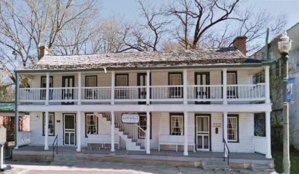
Old Stagecoach Stop
Listed in the National Register of Historic Places
Turn right along N. Lynn St. to visit the "Historic Stagecoach Stop", at 105 N Lynn St.

Stagecoach Stop ca. 1900s. Source
Built by William McDonald in the mid-1850s, it was originally a complex with two log cabins. Later it was rebuilt in wood with an Antebellum style.
It was a stagecoach stop for the Burden and Woodson stage; and also a tavern. During the Civil War served as a Union hospital.
It is the oldest standing structure in the county.
By 1982 was in such bad shape that it had been condemned by the city however, the local citizens saved it and restored it to its former glory. It houses the Old Stagecoach Stop Museum.
Historic Stagecoach stop in Waynesville, Missouri
Rigsby's Station and Home
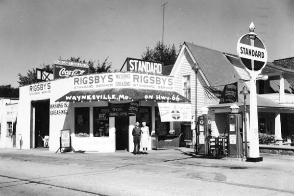
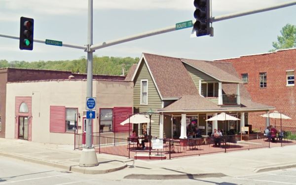
On the next corner along Route 66 is the old "Rigsby Station and Home", to your right, on the NW corner at 103 N. Benton St.
It had been the home of Claude and Eva Rigsby since 1924. Claude ran his Standard Oil Service Station next to his home until 1957. They rented rooms in their home to men who were working in the construction of Fort Leonard Wood in the early 1940s and it was also a gift shop and restaurant.
Below is a "Then and Now" set of photos of one of Wanyesville's Route 66 classics, Rigsby’s Service station.
1940s photoRigsby’s Standard Oil Service Station in Waynesville, Missouri
Rigsby’s Standard Oil Service Station nowadays
Waynesville Civil War Fort Site
County Historic Marker
To your left two block south along Benton St. and then half a block left up Fort St. there is a historic marker (street view.) It marks the spot of the fort built in 1862 by Union forces under Col. Siegel who took the town and guarded the telegraph line along the "Wire Road". It was demolished after the war in 1865. Waynesville was severely damaged during the Civil War.
Head west along Route 66 and on the western side of Waynesville is Roubidoux Creek. Take a left along Spring Rd. to visit the Cherokee campsite at Laughling Park, with the Trail of Tears Memorial and Interpretative Trail.
Laughling Park, Trail of Tears Memorial site
Laughlin Park in Waynesville (donated by the Laughlin family in 1971 in honor of Roy Laughlin), was one of the many Cherokee encampments during the infamous Trail of Tears forced migration. The park was certified in 2006 by the National Park Service as a site on the Trail of Tears National Historic Trail.
There is a concrete pathway one mile long with wayside exhibits, it runs along Roubidoux River, and crosses the Big Spring or Roubidoux Spring.

Route 66 bridge and Trail of Tears interpetative trail, Source

Wayside exhibit on the Trail of Tears interpetative trail, Source
Route 66 Roubidoux Creek Bridge
At Route 66 and Roubidoux Creek (pronounced "rue-bee-due"). It was designed by the Missouri State Highway Commission, and completed in 1923. It carried State Hwy. 14 across Roubidoux Creek and therefore predates Route 66 by three years.
It replaced a steel bridge on North Street and gave the road a straighter alignment. It is a concrete arch bridge and it was widened in 1939.
Roubidoux Creek is a tributary of the Gasconade River and has its headwaters at a spring close by. It was named after Joseph Roubidoux, a French trapper who founded St. Joseph MO.
Ahead, on the western sid of the the bridge, to your right is the "Bell Hotel" mentioned by Rittenhouse (marked with red arrow in the bride image below).
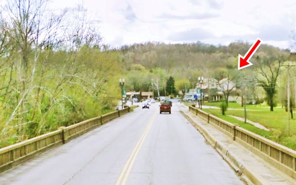
Bell Hotel
At 202 Historic Rte 66. Originally it was the home of judge Robert Bell who turned his home into a hotel in 1925 knowing that Route 66 would be aligned through the town.
He promoted it as "Every Facility for the Traveler's Pleasure". The family ran it until 1937. Now it is the Memorial Chapel of the Waynesville funeral parlor. Despite some changes the old building can be recognized in the "Then and Now" sequence belwos.

Vintage 1930s postcard of the Bell Hotel. Source
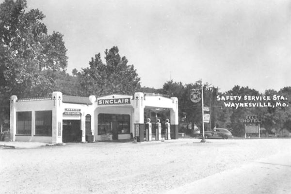
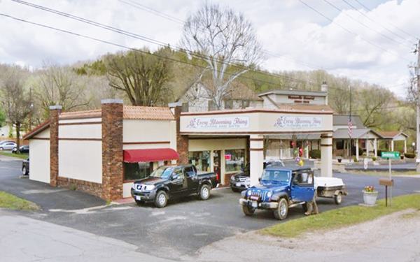
Bell’s Cafe & Sinclair gas station
Adjacent to the hotel, on its western side, is the old Sinclair gas station and Bells Cafe and cabins:
At 206 Historic Rte 66 W. It was a Café and it had a "camp" with nine cabins behind the station to the left, and the garage mentioned by Rittenhouse in 1946. It sold Sinclair gas and was beside the hotel.
Later it was run by the Thomases its motto was "Sleep in Safety and Comfort". The service station sold Sinclair gas. Now it is a florist.
The canopy is still there, and the garage service bay to the left has become part of the office.
Gas station
Across the street, is a rock building at 209 Historic Rte 66 W.
This gable roof stone building was listed in the 1993 Architectural ⁄ Historic Survey of Route 6 in Missouri but no particulars given.
By its layout it appears to have been a service station, now it houses a hair stylist and an insurance broker. See picture.
Mallow's Market - The Owl Cafe(gone)
305 Historic Rte 66 W. Just west of the old station, it was located next to what is now the Drachenfutter coffee shop.
It was originally a stone-faced building as you can see in the black and white picture, later a red-brick wall concealed the stones (see this old street view), and its facade was similar to that of the adjacent Drachenfutter coffee shop.

Mallow's market, 1930s as The Owl Cafe, and during demolition.
The original building reappeared as it was torn down (2015 view), and is now gone (view).
It began as the Owl Cafe; it was ran by Mr. Martin in the building that housed Carl Brisch's garage. Lucille Ransdall bougt it in 1943 and operated it until 1955. Then Merrion Mallow purchased the building and opened a grocery store.
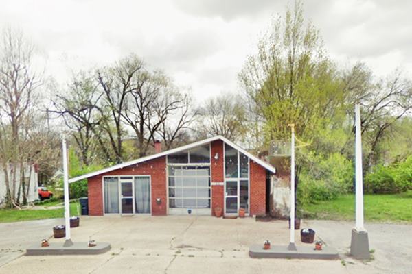
Route 66 gas station
Adjacent to Mallow's, to the west, is an old service station, but no clues as to which brand of gas it sold. It has a ranch-style with a fron-gabled roof, large
glass windows, and red-brick walls.
The two pump islands and the steel pole of its signage are still there. Enco, Humble, and Shell used this style in the 1960s and 70s.
Clark Motel
Across the street, facing the old station, at 310 Rte 66 is the old Clark Motel.
Operated by Mildred and Russell Dial who bought it in 1960. The property was sold in 2001 to the Pulaski County Library.
The Russells lived on the site, in the house on the western side of the property.
This is its street view. Behind it, along Main St. was the old Williams motel.
Bohannon Café Garage
To your left, on the south side of the road opposite Clark Motel is the site of the the old Bohannon Cafe and Garage. At 321 Rte 66 now it is "Ed Wilson Auto Works."
It was built in 1934 and was remodeled not long ago. See its current Street View.
First S & G Motel
On the NW corner of Oak St. between Main and Route 66. It was named after the initials of its owner "Steve Gounis". When he heard that the four-lane Route 66 would bypass Waynesville, he moved to the new alignment, and opened the second S &G motel there.
This marks the end of your Waynesville "City tour". You can drive west to visit Buckhorn and continue your Route 66 road trip.

Some sponsored content
> > Book your Hotel in Lebanon

Credits
Banner image: Hackberry General Store, Hackberry, Arizona by Perla Eichenblat
Jack DeVere Rittenhouse, (1946). A Guide Book to Highway 66
Architectural - Historic Survey of Route 66 in Missouri and Detailed Survey, Maura Johnson. 1993


