Index to this page
Route 66 from Springfield to Joplin
Missouri Route 66 Itinerary and maps
Each leg of Route 66 described below has an interactive map and many image maps so you can follow the alignments of the highway along the way:
- Route 66 in St. Louis MO - map of this segment
- Gray Summit to Rolla - map of this segment
- Rolla to Springfield - map of this segment
- This leg: Springfield to Joplin - map of this segment
Kansas, next leg
Illinois, previous leg
Background on Historic Route 66
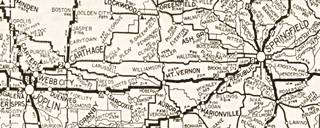
1924 Auto Trails roadmap SW MO
Click on map to enlarge
Source
The thumbnail map (click on it to enlarge) is an "Auto Trail" map printed in 1924. It shows the different highways in the southwestern part of Missouri. Springfield is on the right side, and Joplin on the left side of the map.
These trails were mostly unpaved dirt-surfaced roads that were in poor conditions. The numbers on the map indicate the highway name: #50 was the Ozark Trail and it went through Mt. Vernon and Sarcoxie, roughly where I-44 is now aligned. Trail #2 from Carthage to Joplin was the "Jefferson Highway".
In 1926, Route 66 was aligned along a secondary highway through Avilla, Phelps, and Halltown.
The Ozark Trail was a private association that promoted better highways. Organized in the early 1900s it actively supported roadbuilding and lobbied with the authorities.
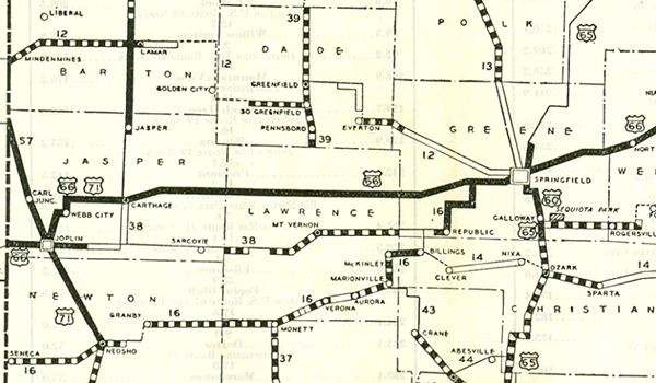
When US 66 was established in 1926 it was mostly aligned along these pre-existing trails.
Above is a map published in 1928 by the Missouri DOT, it shows that Route 66 running across the map, with a thick black line, this means it was paved: "Concrete or High Type Completed."
Later alignments

1956 Roadmap western Missouri. Source
Click image to enlarge map
The thumbnail map (click it to enlarge) was published in 1956, just before the interstate system was built. It is a Shell Highway Map of Western Missouri.
You can follow Route 66 from Springfield to Joplin (to the left). And parallel to it, beneath US66, its spur US 166 that continued into Kansas beyond Baxter Springs. I-44 would in part be aligned along US 166.

Route 66 from Springfield to Joplin
Thinking about visitingt Branson?
Some tours and sightseeing
Sponsored
Springfield, starting point of this leg
We will start on the eastern side of Springfield, cross the city and head west.
The thumbnail map (click on it to enlarge) shows all of the alignments of Route 66 across Springfield, Missouri. Below we describe them and include our custom interactive map links.
1926-1930 Route 66 into Springfield
Coming from Strafford in the east, towards Springfield the first alignment of Route 66 had a zig-zag alignment with sharp 90° turns.
1930-77 Route 66 (City 66) into Springfield
When it was paved around 1930 it was given a new alignment further north and it entered the city along what is now MO-66 and Glenstone Ave. it met the old alignment and went across the city. following the original 1926 alignment through Springfield's downtown area.
>> orange line in custom map shows the 1926-30 US66 into Springfield.
>> violet line in custom map shows the 1930-1977 "City 66" into Springfield.
1926-77 Route 66 (City 66) across Springfield
>> red line in our custom map is the >1926-77 Route 66 (City 66) across Springfield.
1936-54 Bypass 66 around Springfield.
In his "Guidebook to US Highway 66", Jack Rittenhouse pointed out back in 1946 that "There are two routes: through the town on City 66 or around it on Bypass 66" the bypass was created in 1936 because traffic congested the commercial district of Springfield (it also carried US 65) so a bypass was approved and built around the city.
It solved the problem. Rittenhouse added that those driving "Straight through in a hurry" should take the bypass because it "avoid[ed] city traffic".
The bypass ran westbound along Kearney until reaching what is now US 160, and there took a left, southbound to what is now I-44 Business loop, where it met the other alignment, turned right and headed west. It is shown in Pale Blue in the map above and in the custwom map below. It would remain in use until 1954.
>> pale blue line in our custom map is the >1936-54 Route 66 (Bypass 66) around Springfield.
1955-1977 Route 66
In 1955 Route 66 was aligned along I-44 and remained there until it was decertified in both Illinois and most of Missouri in 1978.
Original 1930 roadbed
There is a section of the original 1930s Route 66 Roadbed on the SE corner of the intersection of Kearney and Glenstone. Here is where the road from Strafford curved southwards towards Springfield. This is a map of the segment, 0.2 miles long.
West side of Springfield: Plano and Halltown
1926-60 Alignment
After crossing the town, all alignments meet at US 160 and W Chestnut Expressway, and head west, leaving Springfield behind.
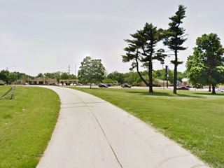
The 1926 - 1960 US 66 alignment was modified just west of I-44's exit 72. To fit the western access ramps, former US-66 (now MO-266) was moved to the north and then south again. Cutting off the original alignment. This road segment became Trail View Rd. next to Deer Lake Golf Course. It has a gap at each end.
>> pale blue line in our custom map is the driveable part. The gaps are marked with orange lines.
The highway follows MO-266 all the way to the "ghost town" of Plano and then headed west into Halltown.
>> pale blue line in our custom map show the Springfield to Halltown alignment (driveable)
Bloody Bridges
Before reaching Plano there were two "Bloody Bridges": one on a curve at Pickering Creek and another dangerous bridge at Sac River. The road was straightened out in 1972 (when it was no longer used as US66) we marked the eliminated roadbed in our custom map and also the remaining segment that can be driven on W Farm Rd.:
>> red line in our custom map is the W Farm Rd. section. The gaps are marked with a green line.
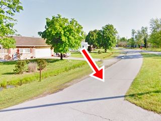
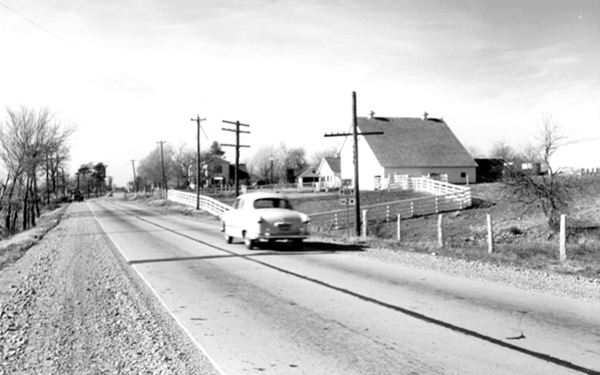
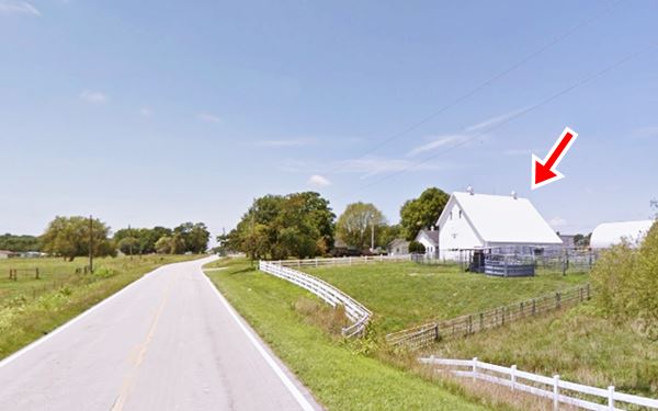
Below is a "Then and Now" image sequence from the 1950s and nowadays of Route 66 on the eastern side of Halltown.
A 1950s photo entering Halltown from the east along Route 66
Same spot nowadays, entering Halltown from the east along Route 66 (same barn marked with red arrow).
Halltown Bridge (1923)
Just west of Halltown is an original narrow steel bridge. It was built in 1923 and carries Route 66 across Billies Creek. It is a riveted single-span Pratt Pony Truss. See picture.
1960 - 1978 alignment west of Springfield
After 1958 (the MO DOT map shows it in the early 1960s) Route 66 was realigned further north together with I-44. They overlapped around Springfield. At that time the former alignment along Kearney St. became BR-66.
I-44 and US-66 headed around town and then west towards Halltown, where they split, I-44 went to the southwest, and US-66 west towards Carthage.
Halltown
Halltown remained on Route 66 until 1961 when Route 66 was aligned along former US-166 together with I-44. Route 66 and I-44 split at Exit 57. US 66 ran to the NE into Paris Springs, meeting the 1926-60 alignment coming from Halltown.
The road east of Halltown into Springfield then became MO-266.
Paris Springs and Spencer
The thumbnail map (click on it to enlarge) shows the different alignments west of Halltown, through Spencer and Paris Springs.
- 1926-1960 Alignment. Green line in our custom map
- 1960-1977 Alignment. Blue line in our custom map
>> Blue and Green lines in our custom map mark these two alignments.
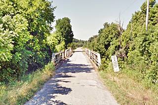
There are two very old (almost 100 years!) bridges, both built in 1923, between Paris Springs and Spencer. The first one crosses Turnback Creek; it is a triple pony-struss bridge, pictured below.
The second bridge is just ahead, as the highway turns west into Spencer, it is a riveted steel bridge, "5-panel Pratt Through Truss", it is pictured above.
Old Segment in Miller
The thumbnail map (click to enlarge) shows the two alignments west of Spencer. In red, the original 1926-61 Route 66 roadbed. The blue line is the alignment after 1961 that bypassed Spencer. Notice how the later alignment runs towards Heatonville south of the original roadbed. The dashed line is the segment cut by the 1961 realignment. The image below looks east from the north side of the 1961 US66, the gray shaded area shows the missing section cut by the later U.S. 66 alignment. (1) shows the 1926-61 alignment and (2) the alignment after 1961.
Alignment in Spencer MO
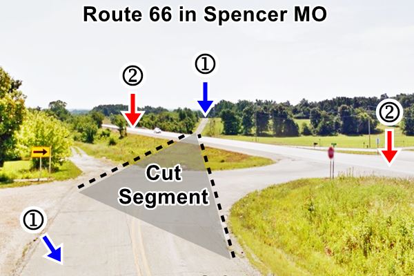
On the western side of Spencer the original roadbed (1) runs in a parallel course to the 1960 alignment (2), a few feet to your right on the north side of the later alignment. See this Map.
West to Heatonville, Albatross, Phelp, Rescue, Plew, and Avilla
West of Spencer and over the next 30 miles, the highway has a clear east-to-west alignment and goes through a series of small villages strung along it: Heatonville, Albatross, Phelps, Rescue, Plew, and Avilla. This straight alignment ends on the eastern side of Carthage.
>> pale blue line in our custom map is the Spencer to Carthage driveable US66 1920-77
The 1955 Realignment of Route 66 in Phelps
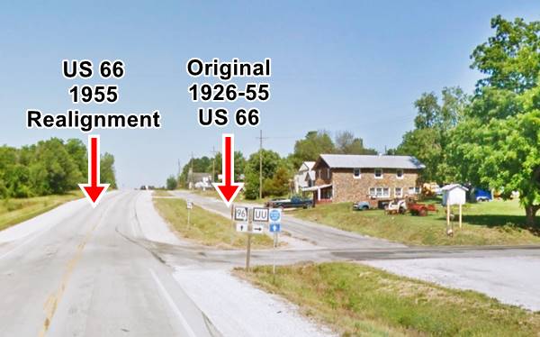
In Phelps the town's buildings are on the north side of MO-96, next to a "frontage road" and that there are no buildings on the south side of the higway. This is so because the frontage road was the original alignment of U.S. 66 through Phelps. It was "straightened out" in 1955.
By Austin Whittall
Click image for Street View
This realignment meant that all the buildings lying in the way of the newer (present) alignment were demolished.
>> red line in our custom map is the old alignment (1926-55) in Phelps.
Route 66 in Carthage, MO
There are several alignments across Carthage.
In the early 1900s there were some roads that could be driven by cars (in fair weather). The map below, published in 1900, shows (marked with red arrows) the course of one of these roads which would become the Auto Trail No. 2 (Jefferson Trail or old Jefferson Highway) through Carthage (1915-1926), and it was paved and designated as Missouri State Highway No. 1 after 1921. In 1926 it became U.S. 66.
Maps of US 66 in Carthage
The map above shows the different US 66 alignments into Carthage. Below are detailed maps; all can be driven except for the gaps in the alignment:
1926-54 US 66
East of Carthage
It followed Jiminy Ln. (Lake Kellogg didn't exist until 1953), and crossed Spring River on a bridge built in the 1920s and removed in 1954, only the abutments of the old bridge remain in place.
>> red line in our custom map is 1926-54 US66. Gap at the river in black.
Dogleg into downtown
The 1926 highway turned south after the bridge and had a grade crossing on the railroad along River St. it then then turned sharply west onto Central Ave.
>> blue line in our custom map is the 1926-34 dogleg
Dogleg eliminated (1934)
In 1934 a viaduct was built across the railroad avoiding the grade crossing and the 90° turn.
>> yellow line in our custom map is the 1934 viaduct and dogleg bypass.
Downtown and westwards (1926-34)
From eastern Carthage to modern I-49BL. That cuts it, so does I-49 in its middle section.
>> green line in our custom map is the 1926 US66 West of Carthage
West of I-49BL into Carterville and onwards to Webb City
This segment can be driven with no gaps.
>> light blue line in our custom map is the 1926-58 US66 west to Carterville and Webb City.
1934 Improvements
The zig zag at current I-49BL was eliminated in 1934 with a shorter and straighter alignment west of S. Rabbit lane.
>> pink line in our custom map is the 1934 realignment W of Carthage.
1954-76 US 66
On the eastern side of the city, a wider roadway was built in 1953 north of the old one. Lake Kellog was formed as a borrow pit, when 28 acres of land were dug up and the earth used on Route 66's new 1953 alignment. The land belonged to the Kellogg Farm and its owners deeded it to a local wildlife and conservation organization as the site of a lake for fishing and recreation. Fed by water pumped from Spring River, it opened in 1954.
In the town, by 1963 Route 66 avoided the urbanized Oak St. alignment. Instead it joined US-71 and went west along Central Ave, curving to the South West along a now truncated West Old 66 Blvd. This road then met the older alignment by the Municipal Park.
See the maps below with the changes in the alignment, otherwise it follows the previous roadbed.
1954-76 East of Carthage
>> Gray line in our custom map is the 1954-76 US66 E of Carthage
West across Carthage
Along Central Ave. At the current exchange of MO-171 and I-49 there is a gap where the old road curve to the SW. But ahead, the W Old 66 Blvd can still be driven.
>> violet line in our custom map is the 1953-76 US66 across Carthage.
Alt Route 66
Rittenhouse in his 1946 guidebook tells us that Route 66 forked on the eastern side of Carthage: "City 66 turns left, main US 66 goes straight ahead", the city route was shorter had light traffic and did not slow you down.
You can see the Alt 66 alignment (built in 1933) along the north side of the city in this map of Alt 66.
Alternate US 66
The American Association of State Highway and Transportation Officials (AASHTO) created the "Alternate" designation in 1959. Its purpose was to designate a route that branches off from the main highway, passes through given towns or cities and then connects again with the main numbered route. The idea is to accommodate a high traffic demand. When the Alternate and Main highways followed a similar course, the shorter and better built highway would be marked as main and the other as alternate.
There are only six places along Route 66 where an Alternate 66 alignment existed: From East to West they were the one into Chicago, this one in Carthage and one futher ahead, on this leg of Route 66, in Joplin, Oklahoma City, Alt 66 in San Bernardino, California, and the one leading into Los Angeles CA.
>> orange line in our custom map is the ALT 66 alignment.
Carterville
All alignments between 1926 and 1958 crossed "downtown" Carterville along the alignment shown in our map.
>> light blue line in our custom map is the 1926-58 US66 west to Carterville and Webb City.
In 1958 Missouri DOT map and the 1963 the USGS map of the area show that US 66 was realigned along what is now I-49 BL. Route 66 continued going through Carterville as BR 66 along Main St. (map of BR 66).
Webb City
Route 66 crossed Webb City from East to West and turned South along Jefferson St. but, now this alignment is cut by the highway median on W MacArthur Dr.
It carried on straight south, along S. Jefferson St. and then curved (see image) onto S. 14th St. to reach S Madison St. and head towards Joplin as shown in the following map.
>> teal line in our custom map is the 1926-37 alignment Webb City to Joplin
1937-45 US66. Later Alt 66
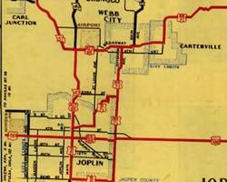
Alt 66 alignment, and US66 in Carterville, Webb City and Jopin 1945-46. Source
Click on map to enlarge
It continued west and then curved into MacArthur Dr. to reach Joplin with a straighter alignment that ran further west as shown in the map below.
This is one more of the six "Alternate" alignments of Route 66. You can see it in the image map, a MO DOT roadmap from 1945 ⁄ 46 - click on it to enlarge it. It still figured as an Alt 66 in the 1948 roadmap, but in the next edition in 1953 it was no longer signed as an Alternate highway.
>> blue line in our custom map is the 1937-45 US 66 into Joplin.
The 1945-1978 US66
The "City" or "Main" alignment of Route 66 through Joplin from 1945 to 1978 is shown in the following map.
>> pale blue line in our custom map is the 1945-78 Main 66
Route 66 in Joplin
The thumbnail map (click it to enlarge) shows the different alignments of Route 66 through Joplin.
Why did the 1926 alignment have such a winding course?
The meandering and twisting course of Route 66 in its first alignment has a very simple explanation: it followed the rails of the Southwest Missouri Electric Railway, a streetcar (tramway) that linked Carthage, Carterville, Webb City and Joplin with Galena Kansas and Miami in Oklahoma. The company was established in 1893 and transported many passengers until the car began taking over. By the time U.S. 66 was created it had already began using buses instead of streetcars. Shortly after it lifted its tracks and the old railroad bed became the new U.S. 66 highway roadbed and shared with U.S. 71. This route was replaced by a more direct one with less curves and therefore quicker and safer in 1937.
To state line MO-KS
Head west along 7th from Main. It is only 5.8 miles to the Kansas state line along Old Route 66. There is a fork on the higway just before you reach the it.
The road to the right is the original 1926 - 1961 alignment and is the continuation of "Old Route 66 Boulevard."
To the left is
the 1961-85 alignment into Kansas and Galena.
>> orange line in our custom map is the 1961-85 segment
The original 1926-61 alignment heads west as "West Old 66 Blvd." As you approach Kansas (only 0.5 miles west) you will come across some "last chance" gas stations on Route 66 right beside the Kansas state line. This was a bustling community called "Central City", it also had many liquor stores which served the Kansans at a time when Kansas was a "dry" state.
The Final Route 66 alignment in Joplin 1978-85
On June 24, 1974, the American Association of State Highway and Transportation (or AASHTO) decided to move the eastern terminus of Route 66 from Chicago, Illinois to western Missouri, placing it close to Joplin in Missouri.
This shortened Route 66 eliminating its designation in Illinois and most of Missouri.
The new eastern terminus was located at I-44's exit 15 east of Joplin, in the town of Scotland MO (see it on a map).
>> burgundy line in our custom map is the 1978-85 US 66
Decertified in Illinois and most of Missouri - 1974
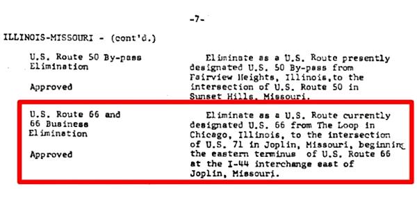
It wasn't implemented immediately, but you can see it in this MO DOT map from 1978.
Our itinerary from Springfield to the Kansas - Missouri state line in Joplin ends here, you can carry on westwards into Kansas, see below.

Some sponsored content
> > Book your Hotel in Joplin.

Credits
Banner image: Hackberry General Store, Hackberry, California by Perla Eichenblat
Jack DeVere Rittenhouse, (1946). A Guide Book to Highway 66.
Route 66 Maps. Missouri D.O.T.


