Index to this page
Historic Route 66 Gray Summit to Rolla
Background on Historic Route 66
The first trail in the area was opened by deer and buffalo, and later used by Indians. It followed the divide in the Ozarks. After the late 1600s, white explorers and trappers followed it; they named it the "Great Osage Trail" (after the Osage Indians). The road used to build and service the military telegraph line built in the 1860s followed it and was known as the "Wire Road"; it became the main road between Rolla and St. Louis.
During the early 1910s, cars became more frequent in the Ozarks but the roads were full of potholes or muddy traps during the rainy periods. The Inter-Ozarks Highway Association lobbied successfully for a decent state highwy and that is how MO-14 was built between Rolla and St. Louis, and given a gravel surface. Route 66 was aligned along it in 1926.
Route 66 from Gray Summit to Rolla
Missouri Route 66 Itinerary and maps
Each leg of Route 66 described below has an interactive map and many image maps so you can follow the alignments of the highway along the way:
- Route 66 in St. Louis MO - map of this segment
- This leg: Gray Summit to Rolla - map of this segment
- Rolla to Springfield - map of this segment
- Springfield to Joplin - map of this segment
Kansas, next leg
Illinois, previous leg
Gray Summit, starting point of this leg
Old Route 66 in Gray Summit
In the 1830s, the main road from St. Louis to the state's capitol city, Jefferson City, ran along what is now MO-100 to Gray Summit and then west along what is now US-50. It carried the stagecoach.
Route 66 was aligned along both of these highways in 1926, and was paved between St. Louis and Gray Summit.
1926 Map of Route 66 from St. James to St. Louis, Missouri, notice that this first map says "formerly marked US 60" (read more about this: Route 66 was born as US 60). Gray Summit is where the black and dashed lines meet.
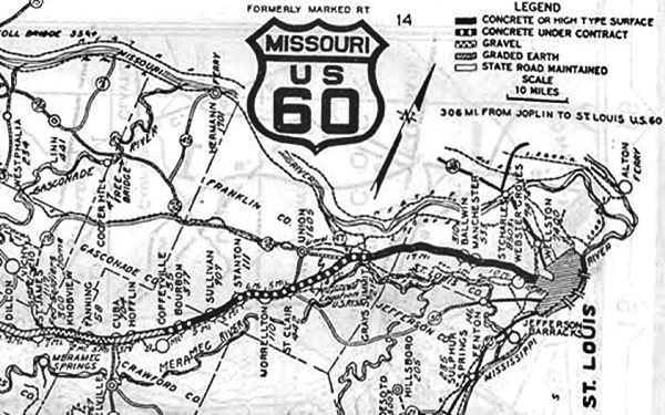
Rosati appears under its old name of "Knobview". see large map: Missouri Highway Map Archive
From Gray Summit to Villa Ridge
We will start our journey in the small town of Gray Summit and drive west towards Villa Ridge. It is a short 2.7 mile drive along Route 66, and this is its Map with Directions.
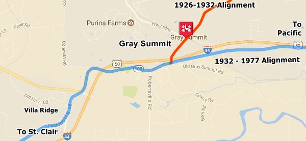
The image above shows, in Orange the 1926 to 1932 alignment of Route 66 from St. Louis to Gray Summit.
Pale Blue, west of Gray Summit marks the 1926 - 1953 US 66, and east, it is the 1932 to 1953 Route 66 that bypassed older one.
1950s: Four Lane Freeway
By the early 1940s Route 66 had become congested in this area, heavy traffic made it dangerous so the road was widened. Jack DeVere Rittenhouse in his "A Guide Book to Highway 66" published in 1946 mentions that "From here into St. Louis, US 66 has three or more lanes." In the early 1950 most of the original road was bypassed by a new four-lane divided dual carriageway highway replacing the old US 66. At that time, US 50 followed what is now MO-100 and in the late 1950s US 66 was also numbered as I-44.
The state petitioned in 1962 to have the Interstate renamed as I-66 instead of I-44, but this was denied by the AASHTO because the number "66" had already been used elsewhere.
1969 New roadbed
The old four lane US-66 ⁄ I-44 Freeway was improved again in Missouri after 1967, and the old US 66 was upgraded to Interstate standards as attested by the USGS 1963 Map revised in 1969, the four lane divided I-44 carried US-66 and US-50 and bypassed the original road in Gray Summit. By 1972 the whole of Route 66 had been replaced by the Interstate system. In 1974 it was decided that US Hwy 66 between Joplin and Chicago be eliminated, but his was delayed until I-55 in Illinois was completely brought up to Interstate standards. In 1977 the US 66 shields and signs were removed.
Villa Ridge
Historic context, the classic Route 66 in Villa Ridge

Keys Cafe originally at Villa Ridge neon sign; now at Route 66 State Park,
The WPA travel guide "Missouri, a guide to the "Show Me" state" published in 1941 describes the region around Villa Ridge, it tells us that US 66 and US 50 unite for 6.5 miles at Gray Summit, passing the Missouri Botanical Garden and 1.9 mi. west "is a junction with State 100. West of the junction the highway rides a curving ridge that descends into the Bourbeuse River Valley. Approaching the river, the highway divides into one-way lanes and crosses the river on twin steel and concrete bridges."
Jack DeVere Rittenhouse tells us that "US 66 crosses the Bourbeuse River here on a double bridge."
Just ahead, 0.3 mi. west is the site of the Twin Bridges (actually now there are three bridges, one for Route 66 and two for I-44).
Twin Bridges
Route 66 (Hwy AT) and I-44, at Borbeuse River. The "Keys Twin Bridge Cafe" (see picture) was just east of the bridge.
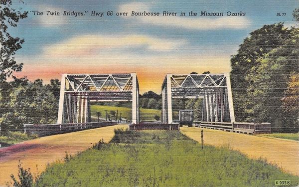
The first bridge across the Bourbeuse River was built in 1925 and one year later it carried US 66. In 1935 another bridge was built next to it, and the eastbound lanes were aligned along it. The original 1925 bridge carried the westbound traffic.
The bridges were steel truss bridges, and in 1958 when the highway was improved to four-lanes all across the state, the old bridges were replaced with steel girder bridges. The old 1949 postcard (see image) shows both bridges side by side, looking west with the 1925 bridge on the left side of the image, and is its street view today, at that same spot.
After the bridge, the original Route 66 is now obliterated by the exchange between I-44 and US 50. But you can see it in this "missing segments map", marked with a blue line. See the map from Villa Ridge to this point.
Take the new roadbed of Route 66 to cross US 50 and head west along the Mother Road that runs along the north side of I-44 as its frontage road all the way to Exit 242 as shown in this map (west of V. Ridge).
Here is another missing segment just before reaching Exit 242, as I-44 cut across the original Route 66 roadbed, that resurfaces as the South Frontage Rd. shown in this map (purple line).
St. Clair
Route 66 realigned in St. Clair
The original 1926-50s Route 66 in St. Clair ran with a diagonal course between Sincox St. and Walnut St., where it met MO-30, as shown in this map (violet line). The black lines in the map show the streets that were later eliminated or cut off: Maple and W. Oak streets are now cut off on the western side of the present alignment of US 66, but in those days continued east, crossing Commercial Ave., which ran straight southwards, ending at the junction of Walnut St. and Gravois Ave. The two stunted forks of S. Lay Ave. which now have dead ends to the east of current Commercial Ave. both reached it in those days.
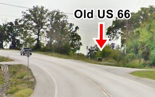
Later during the late 1950s, Route 66 was realigned where I-44 is now located. The present alignment was built in 2009, abandoning the old Route 66, a portion of which can still be seen at the dead end of W. Oak St. to your right on the west side of the highway (see image looking west, red arrow).
South of St. Clair the original Route 66 can be driven for 1.5 miles before it reaches I-44 which cut it off and now runs over the old alignment. See this map South of St. Clair.

It is overlaid by I-44 after that point map (gray line) and resurfaces on the South Service Rd for a short stretch (map), before swinging to the north (cut by I-44, second gray line in the map) to follow a wide arch between Wildwood Estates Rd. and Tag-A-Long Rd (map of this arch).
It is again buried by the freeway (violet line in our custom map) and it resurfaces again when the old road curves away from I-44 and then goes through "Benson Tourist City" as shown in this map at Benson Tourist City.
It appears again (see map) between Tuttle Ridge Rd. and Whispering Pines Dr., after this point it is buried by the freeway.
The north Service Road built when the 4-lane Route 66 was upgraded to Interstate standards, and that now carries Route 66 towards Stanton follows the original US66 alignment quite accurately (map).
Stanton

Route 66 in Stanton, 1946 USGS Map
The image map (USGS 1946) shows the original alignment (red line) and the new set of lanes built in the mid 1940s (black arrow).
As you approach Stanton, the original road ran on the eastern side of the freeway and is partly buried beneath the eastbound lanes. The first section just north of Stanton can still be seen (map), the rest is gone (map with a pink line).
Sullivan
Driving west from Stanton to Sullivan, the original 1926-50 alignment is shown in this map all the way to the north side of Winsel Creek just past Glaser Rd.
Route 66 alignments at Winsel Creek over the years
1926-Late 1940s
As you approach the creek, the original 1926 to late 1940s Route 66 had an "S" shaped alignment from 1926 until the late 1940s. See this alignment in this map (yellow line) and in the following images (click on the thumbnails to see full sized pictures):
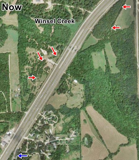
The red arrows mark the original Route 66 alignment used from 1926 to the late 1940s. The blue arrow at the bottom shows where it continues on the eastern side of the freeway that now cuts the old roadway.

Aerial photograph from 1945. Source
Tragic Curve
Lowell Silverman wrote an excellent article on the life of 2nd Lieutenant Paul W. Taylor (1911–1942) (read the full article) who died in a tragic accident here on this curve at Winsel Creek, on Route 66 during World War II.
On the night of September 27–28, 1942, Taylor and five other officers were traveling back to Fort Leonard Wood on U.S. Route 66 in a Chevrolet coupe. Shortly after midnight their vehicle collided with a cattle truck roughly midway between the towns of Stanton and Sullivan, Missouri. Three men were killed: 2nd Lieutenants Taylor, Ennas Calvin Cave (1919–1942), and Booker T. Owens (probably 1913–1942), the driver...Lowell Silverman
We marked the spot of the accident with a cross in our custom map.
1949 alignment
As shown in the USGS map published in 1949 (above) this original "S" on the upper right side of the map was cut off by a new 2-lane roadway (perhaps built during WWII?), it runs straighter than the old one, and bypasses Sullivan along its western side. This two-lane highway complements the original one going through Sullivan. The map doesn't clarify if they both carried east and westbound traffic or if they were exclusively eastbound (old 66) and westbound (new-straight alignment). See the (map of this segment).
1955 Alignment
By 1955 (see image below), the four-lane Route 66 had been built and its dual set of lanes finally cut off the original 1926 roadway at Winsel Creek. What are now the North and South Service Roads didn't exist at that time.
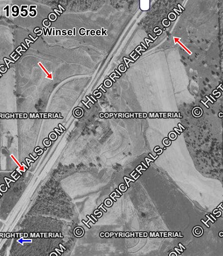
Aerial photograph from 1955. Source
Satellite view nowadays
Current alignments
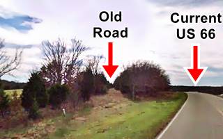
The current satellite view of the area (above) shows the modern I-44 that replaced the old four-lane US66 (eliminating grade crossings), and the "modern" US 66 running along the eastern side of the freeway. It replaced the old alignment, which was abandoned but can still be seen in some spots, lined with trees (marked with the red arrows). The images shows a current view of the old roadway on the north side of Winsel Creek and the "modern" US 66 which was built later, as the freeway's service road.
On the south side of the creek, the road can be driven all the way into Sullivan, and across it till it ends on its south side at Cristland Dr. See this map of Route 66 across Sullivan. West of this point the old roadbed lies beneath the EB lanes of I-44 as shown in this custom map (orange line).
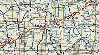
Click on the thumbnail image to enlarge it. It is a Shell road map published in 1956, it shows the alignment of Route 66 from Sullivan (upper right) to Waynesville through Rolla (in the middle of the map). At that time the highway was mostly a four lane highway, one that preceded current I-44. Notice the split alignment through Cuba (more on this below).
Towards Cuba
Sullivan to Bourbon
Bourbon
U.S. 66 resurfaces again as the S. Service Rd. and runs next to the freeway all the way to Bourbon through St. Cloud (map to Bourbon).
Later it would become the EB lanes of the four-lane Route 66 whose WB lanes were located where the freeway's EB lanes now run.
Hofflins

USGS map of Hofflins in 1948, red arrow marks Route 66.
The highway continues along the South side of the freeway from Bourbon to Hofflins. See this map with the Bourbon to Hofflins alignment.
From Hofflins to Cuba
Cuba
It is a 3.5 mi. drive from Hofflins to Cuba along Old Route 66.
Route 66 originally ran along State Highway 14, and Man St. into Cuba. Arthur Eads (Source: >Show me Route 66) recalled in 1996 that "Main St. [was] original 66 in Cuba. It was 1927... until the "new" 66 (Washington) was paved in 1928". The whole dirt road was finally paved by 1931.
On the eastern side of the city, Route 66 forked at a "Y" junction, away from Springfield Rd. which went along Main St., while Route 66 went along Washington St.
According to Missouri States Parks and the National Parks Service, the hotels on Main Street built new fronts facing Washington St. (Route 66) to attract the new customers that drove along Route 66.
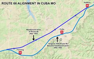
Starting in the early 1950s Route 66 became too congested in the neighboring town Cuba. So it was upgraded to a four-lane highway in which the original 1926 Route 66 alignment through Hofflins became the two eastbound lanes of the new "super highway" between Hofflins and Fanning (Pale Blue in the map below). Two additional new lanes were built (shown in Blue in the map below - click thumbnail image to enlarge) from what is now Exit 203 to Exit 210 at Hofflins to carry the westbound traffic.
This is the map of the 1926 Route 66, later the EB lanes, from Hofflins to Fanning through Cuba.

USGS map of Fanning to Hofflins through Cuba 1966, Route 66 is shown in Red.
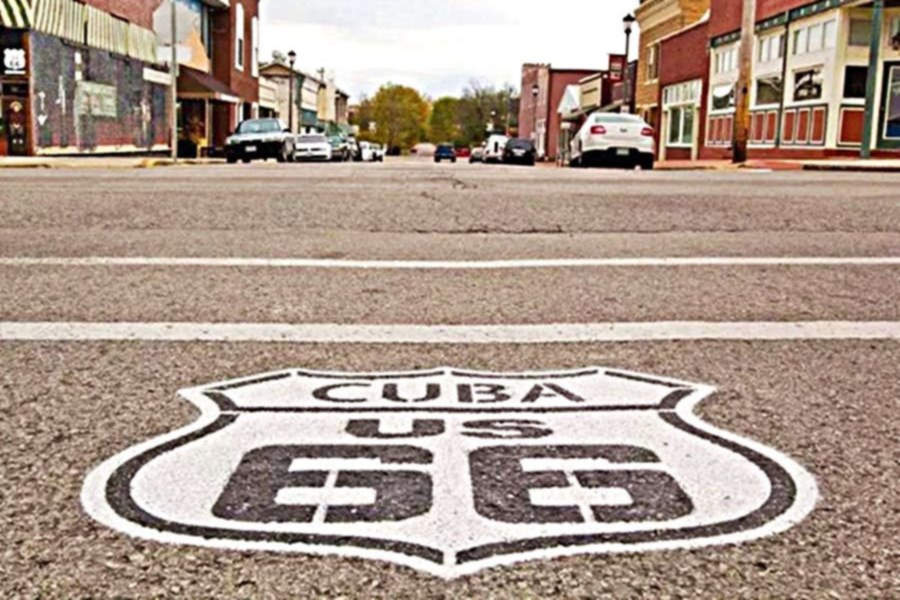
Shield on an intersection in downtown Cuba Missouri
Fanning

USGS map of Fanning in 1948, Route 66 is shown in Red.
Fanning is a small community just west of Cuba. The 1926 alignment of Route 66 passed through Fanning on the south side of the railroad. Nothing remains of this original roadbed.
In 1930, it was paved and moved to the north side of the tracks. The original US 66 is now named Highway ZZ. The image shows the 1948 USGS map with Route 66 through Fanning.
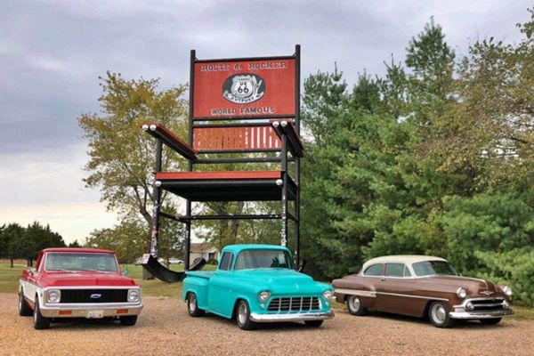
While driving through Fanning, stop to visit the "Red Rocker" the second largest rocking chair in the world.
Route 66 Red Rocker
Rosati

USGS map of Rostati in 1938, Route 66 is shown in Red.
The next "town" westwards is Rosati, a small community that grew next to a railroad depot south of Route 66. The old US66 runs along the S Service Rd. from Fanning, through Rosati and into St. James as shown in this map.
St. James
Route 66 enters St. James from the east along KK Hwy (Historic Route 66), cuts across the town (map of Route 66 in St. James) and then heads west along W James Blvd. Its original alignment on the western side of the town is now cut by the freeway as shown in this map (green line). Then it headed west towards Rolla along the North Service Rd. in the last leg of this segment.
Route 66 in Rolla
Route 66 into Rolla from the East
The final section of our itinerary is the eastern access into Rolla coming from St. James.
The highway runs along the N Service Rd. as shown in this Map. At Exit 189 there were several changes to the original roadbed westwards, towards Rolla.

1928 USGS Map east of Rolla
Dead Man's Curve east of Rolla
Coming from St. James, the original 1926 highway was a two-lane gravel road, it ran along what is now the north frontage road of I-44, known as Historic Route 66.
Just after passing the site marked with a Benchmark as "Dunivin" (see the 1928 USGS map), it curved sharply with a 90° curve, to the north (red arrow) and headed along what is now County Rd. 39 then it curved widly to enter Rolla - see blue arrows. (Map 1926 alignment), the dead man's curve is now under I-44 at the eastern tip of this alignment. We marked it with a red line in this Map of the Dead man's curve (red line).
This was later straightened out. By the 1940s, as it approached Rolla, it followed a softer curved alignment, one that is now cut by I-44. You can see it as the orange line in Map of US66 east of Rolla. This map is based on the 1949 USGS Map of Rolla and US highway 66, notice that at that time it no longer followed the current "Historic Route 66" - County Rd. 39; instead it took the now cut-off County Rd. 2000. The alignment that can be driven into Rolla is shown in this Map into Rolla, from Co. Rd. 2000 to N. Pine St.
See all of these alignments in our custom map.
Our itinerary from Gray Summit to Rolla ends here, you can carry on with your Route 66 Road Trip westwards to Springfield, see below.

Some sponsored content
> > Book your Hotel in Rolla.

Credits
Banner image: Hackberry General Store, Hackberry, California by Perla Eichenblat
Jack DeVere Rittenhouse, (1946). A Guide Book to Highway 66.
Route 66 Maps. Missouri D.O.T.


