Index to this page
Route 66 from Rolla to Springfield
Missouri Route 66 Itinerary and maps
Each leg of Route 66 described below has an interactive map and many image maps so you can follow the alignments of the highway along the way:
- Route 66 in St. Louis MO - map of this segment
- Gray Summit to Rolla - map of this segment
- This leg: Rolla to Springfield - map of this segment
- Springfield to Joplin - map of this segment
Kansas, next leg
Illinois, previous leg
Rolla, starting point of this leg
We will start on the north side of Rolla, cross the city and head west.
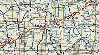
Click on the thumbnail image to enlarge it. It is a Shell road map published in 1956, it shows the alignment of Route 66 from Sullivan to Waynesville through Rolla (in the middle of the map). At that time the highway was mostly a four lane highway, one that preceded current I-44.
Alignments of US 66 in Rolla
Jack DeVere Rittenhouse mentions Rolla in his 1946 "A Guide Book to Highway 66" and tells us that there were two route alignments in Rolla: "City 66" and "Main US 66", around the business district."
City 66
The original 1926 alignment of US 66 in town went along Pine Street, with traffic flowing in both directions. This congested the downtown area so soon the westbound traffic was moved to N. Rolla St.
>> blue line in our custom map marks City 66 map.
Main 66
During the 1940s a bypass was built, around the business district along Bishop Ave.
>> red line in our custom map marks Main 66.
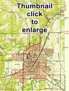
The thumbnail image (clikc on it for full size large map) shows the 1949 alignment from Northwye westwards across Rolla.
1950s Four Lane Alignment in Rolla
Both routes were bypassed in the 1950s by the four lane Route 66 that was a divided highway yet didn't have overpasses and limited access. This old roadbed is now buried under the roadway of I-44 (map with directions).
1966 New roadbed
Beginning in 1967 the old US-66 ⁄ I-44 Freeway was improved again. Eventually the whole of US 66 in this area was upgraded into a four lane limited access highway and after 1958 it coexisted with the new interstate I-44 (a state petition in 1962 to name the highway I-66 was denied by the AASHTO). Finally in 1972 the whole of Route 66 had been replaced by the freeway and in 1974 it was decided that the whole of US 66 from Chicago to Joplin would be eliminated. However this was delayed until I-55 in Illinois was completely brought up to Interstate standards. The signs were removed in 1977 but the last segment of the old Route 66 was bypassed in 1981. The road was delisted in 1985.
Thinking about visitingt Branson?
Some tours and sightseeing
Sponsored
From Rolla west into Doolittle
West towards Doolitle
"City 66" and "Main US 66" met on the western side of Rolla and headed west towards Doolittle.
>> light blue line in our custom map from Rolla to Doolitle.
Dead Man's Curve west of Rolla
The original road is now Martin Springs Drive, just ahead, after Martin Springs the original 1926 road curves sharply towards a very narrow bridge on a curve (Map showing curve). The old Beaver Creek Bridge built in 1926 was recently replaced by a modern one (June 2021). From here it heads into Doolittle.
This "Dead Man's Curve" plus the narrow the Beaver Creek bridge were very dangerous, causing frequent automobile wrecks.
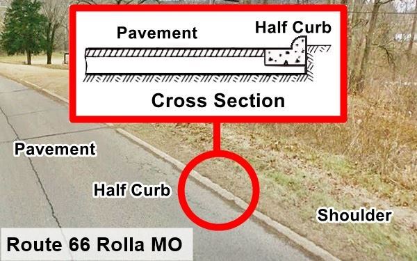
Half Curbs segment of Route 66
This segment west of Rolla towards Doolitle was originally a gravel surfaced road. It was paved in 1931 and a new idea was tested on it, "Half curbs". The idea was that these semicircular flat curbs would help keep the cars on the roadway, acting as a physical barrier to keep them from deviating from the road on curves, and also from wandering off the roadway onto soft shoulders. They were also used on Route 66 in Canute OK.
The idea didn't work. The low curbs actually tipped cars over, causing rollovers and more accidents than they prevented.
Doolittle
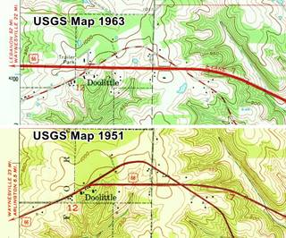
The original 1926 alignment (see thumbnail map, click to see large sized map) had a winding course. It is marked with a red and white line in the 1963 map. Then in the 1950s, a new and straigher alignment was built through Doolitle and east into Rolla. You can see it in the 1951 map. By 1963 it had been expanded to a 4-lane highway that replaced the older one.
1966 New roadbed
Beginning in 1967 the four-lane US-66 ⁄ I-44 Freeway was improved again and upgraded to Interstate standards (previously it had grade level intersections). This cut off the segment of US-66 that forms an arch on the north side of modern I-44.
>> yellow line in our custom map. The green lines at each tip, mark the gaps, where I-44 cut the original alignment.
From Doolittle west through Newburg
Route 66's alighment west towards Newburg. The highway does not enter Newburg, which is located further south. It crosses its western edge. The old road, paved in 1931 runs west from Doolittle and then curves to the south around Newburg towards Arlington.
>> light blue line in our custom map is US 66 from Doolitle to Newburg (1926-51)
West of what is now I-44's exit 176 there were several alignments over the course of the years, linking Newburg with Arlington and Jerome, below we describe them.
Route 66 alignments from Newburg to Arlington
See how the road and its alignments evolved over time just west of Doolittle through Newburg.
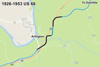
1. 1926 to 1953 alignment: two-lane Route 66
See image (click to enlarge). The Pale Blue line marks the original 1926 to 1952 Route 66 that can still be driven. The Black segments have gone, either removed or buried under later roadbeds.
>> violet line in our custom map marks the 1926-53 US66.
This alignment used the now gone 1923 Bridge across the Little Piney River.
2. Bridges across the Little Piney River and the Railroad
The St. Louis and San Francisco Railroad runs roughly parallel to the Little Piney River, from east to West coming from Newburg and going through Arlington.
Route 66 cut both, at right angles, with a north to sorth course. An overpass was needed to carry the highway over the tracks, and a bridge to cross the river.
1923 Railroad Bridge and the Little Piney River Bridge
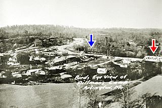
1923 US 66 Bridges at Arlington Missouri.
Click to enlarge. Credits
The photo (click on it to enlarge) looks towards the northeast and shows the village of Arlington (lower left) and Route 66 (right) with the Single-span Pratt Through Truss bridge that carried it over the railroad (center - blue arrow) and (right - red arrow) the first span of the Five-span Pratt Through Truss bridge that carried US 66 across the Little Piney River. You can see Route 66 curving in an "S" in the upper left part of the image.
1932 Railroad Bridge
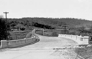
1932 Bridge at Arlington Missouri
Click to enlarge. Credits
The 1923 Railroad bridge was replaced in 1932 with a three-span concrete slab and steel beam bridge. The thumbnail image (click on it to enlarge) shows the new bridge in the foreground. It looks south, showing the the 5-span 1923 steel bridge over the Little Piney River which remained untouched. You can see how US 66 heads to the right into Jerome and its Stony Dell resort.
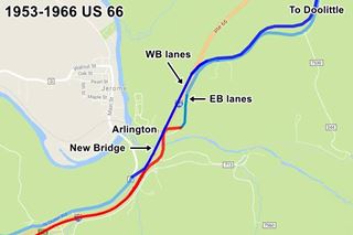
3. 1953 to 1966 alignment: four-lane Route 66
The highway was upgraded and became a four-lane highway. Arlington is now on a dead end of a road that linked it to Route 66's 1926 alignment. When the Mother Road became a four-lane highway in 1954 Arlington was cut off and isolated from the freeway.
A completely new roadbed with two eastbound lanes was built northwards into Arlington, shown in Red in the map (click image to enlarge).
On the south bank of the Little Piney River it linked to the 1926 Route 66, using the 1923 bridge to cross the river. Then it followed the original alignment shown in Pale Blue, which was moved a bit to the east to make space for the two new lanes north of the river. The original road is now the Outer Road W.
At Exit 176, the four lane highway headed east into Rolla and is now under the roadbed of I-44.
A new set of westbound lanes were built (Blue in the image ) westwards from Exit 176 to Arlington. A new bridge was built to carry it across Piney river, and on the south side of the river it linked to the original 1926-53 Route 66, which became the westbound lanes of the new four-lane highway (Pale Blue).
>> orange line in our custom map shows the 1953 Westbound lanes.
1953 "new" Bridge
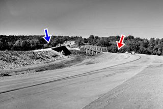
1953 US 66 Bridge at Arlington Missouri.
Click to enlarge. Credits
A new bridge was built to carry the westbound lanes across the Little Piney River, click image to enlarge. The blue arrwow marks the westbound lanes and bridge. It was built to the west of the 1923 steel bridge (red arrow), still in use. The photo looks north from Jerome towards Arlington. The older bridge is on the left and it carried the eastbound traffic once the new one was completed.
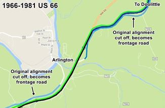
4. 1966 - 1981 alignment
The old original steel bridge across Piney River was at the end of its life span so a new bridge was built to replace it and carry the eastbound lanes of US 66. At that time the road in Arlington was straightened out (Black) and linked to the former westbound lanes (Blue). The original estbound lanes, what is now Outer Rd. W, became a frontage road that only gave access to Arlington (Pale Blue).
A completely new set of westbound lanes were built Green on the north side of Arlington and they met the older Westbound lanes there, and were carried over the Little Piney River by the 1953 bridge.
On the south side of the river, the original roadbed was cut off and became a Frontage Road. The new WB lanes ran parallel to it, but were straighter.
Later developments
The original (EB) bridge at Piney River was removed in 1967. Later in 2006, when Route 66 no longer existed, the whole of I-44 between Exit 176 and Arlington was realigned to the west of the older one. This bypassed the old segment through Newburg. The old 1966 bridge on the WB lanes was replaced in 2009.
South of Arlington
Jerome, Powellville and Clementine
>> light blue line in our map shows the 1926-53 two lane US66
To head further west through Jerome you must bypass the dead end at Arlington using I-44 and once you cross the Little Piney River, get back on the old original 1926 Route 66. This original alignment was a regular two-lane highway, paved by 1931. See this map of US66 1926 alignment from Jerome through Powellville, to Clementine. It is cut by I-44 at Exit 169 on the south side of Clementine.
1950s: Four Lane Freeway
In 1954 a new road, with two lanes was built north from Clementine, through Powellville and Arlington. These new lanes became the new Eastbound lanes south of the Little Piney River.
The original US 66 became the new westbound lanes of this highway. The "new" eastbound lanes ran separately with a much straighter course, and in the 1960s became part of I-44.
Both east and westbound lanes met as a divided highway just south of Powellville, but split again and separated north of it, past the exit to Goodall Cemetery.
1960s New roadbed
Beginning in 1967 the old US-66 ⁄ I-44 Freeway was improved. The winding westbound lanes (which were the original 1926 Route 66) were inadequate. Northwards from Powellville towards Arlington the following was done.
- New straighter eastbound lanes were added, splitting from the older alignment at Powellville.
- The straighter eastbound lanes of the 1950s alignment became the "new" westbound lanes of the 1960 alignment ones from Arlington to a point just north of Powelville
- Through Powellville, the old 1950s four-lane divided freeway was upgraded separating the North Outer Rd. from the new westbound lanes.
From Clementine to Hooker
Into Hooker
South of Clementine at Exit 169 there is a gap so you must cross to the eastern side of the freeway to follow the original Route 66 alignment and drive towards Hooker:
>> pink line in our map shows the gap
1926 to 1943 alignment
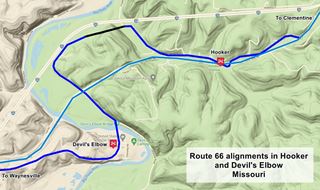
This is the 1926-1943 Google Map from Clementine through Hooker. It is shown in Blue in the image map. Then comes a gap in the alignment (black line). Followed by the western segment that goes through Devil’s Elbow.
>> blue line in our custom map is the 1926-43 US66 in Hooker, Devil's Elbow and Morgan Heights.
The 1943 to 1977 alignment
>> pale blue line in our custom map shows the 1943 4-lane '66 from Hooker and Devil's Elbow to Morgan Heights
The opening of Fort Leonard Wood during World War II brought a large workforce to the area, and while a railroad spur was being built all the materials and men that were to be trained at the new Army base moved in along Route 66. The highway was narrow and winding and also had the 1923 narrow Bridge at Devil's Elbow with a dog leg on it; both unsafe and congested.
1923 Route 66 Bridge in Devil’s Elbow, Missouri
Traffic had tripled and the road became crowded. Accidents increased (53 dead and 454 injured during the first nine months of 1941).

USGS Map from 1942 showing Hooker MO and Route 66.
This had to be solved quickly. The War Department had a four-lane highway built through this dangerous area. Instead of winding around the hills coasting the Big Piney River, the new road would cut a straight line from Clementine to Grandview. The new highway eliminated steep gradients and was wide; it was a four-lane divided highway; a 90 foot-deep cut was made in Hooker and a new concrete bridge built across the Big Piney River to carry it.
See thumbnail of a USGS map from 1942. The red arrows mark the original 1926 alignment winding around hills, the blue arrows mark the new wider and straigher 4-lane highway.
This "freeway" became, together with the Pennsylvania Turnpike, the only two highways with four lanes in the U.S. at that time. The new highway opened in 1943 and consisted of a completely new and straight alignment with two lanes separated by a central curbed division.
Hooker and Devil's Elbow were both bypassed by the new road. This new alignment is shown in Pale Blue in the map, and also in this 1943-1977 Map with directions.
It remained in use even after I-44 replaced US 66 in 1977. It was later bypassed in 1981 by a newer alignment of I-44 which eliminated a section of the old 1926 road (shown in Black in the map).
Old Route 66: 1926-1943 Alignment in Morgan Heights

Route 66 map, Morgan Heights
See this map showing the location of the alignment in Morgan Heights. The image shows the alignment in Blue and the Black lines mark the spots where the modern freeway cuts the old road.
WWII realignment
At Grandview, west of Devil's Elbow the new 4-lane kept straight and bypassed the old curved segment (now on the north side of I-44) through Morgan Heights. The new alignment is shown in Pale Blue in the map.
West of Morgan Heights the four lanes continued, but they were not close to each other. The eastbound lanes followed the original 1926 Alignment which now is Hwy Z. The westbound lanes were new; a straight alignment which is now under I-44, running all the way to Hardy Ln. where all four lanes met and again ran as a divided highway into Ft. Leonard junction with Route 66.
St. Robert to Lebanon
St. Robert
>> pale blue line in our custom map is the 1926-43 Route 66 into St. Robert.
From 1926 to 1943 the highway crossed St. Robert along what is now the westbound lanes as shown in our custom map, During WWII two lanes were built further south and now carry the estbound lanes.
>> red line in our custom map shows the EB lanes.
Waynesville
From St. Robert trough Waynesville Route 66 remained a regular two lane road until the 1950s, when the four lane highway was extended westwards towards Lebanon.
>> pale blue line shows the original 1926-50s Waynesville alignment.
Old Route 66 in Buckhorn
When it approached Buckhorn, until the 1950s, the road continued south (now it is cut by the freeway) and then west along what is now Spruce Rd. into Buckhorn and then it ran along current MO-17 to the next town, Laquey.
>> orange line in our custom map: Buckhorn to Laquey.
In the early 1950s, the four-lane alignment was continued, bypassing Waynesville and following what is now I-44.
In the image you will notice how it all became a four lane freeway (but still named US 66). The original Route 66 was bypassed from Waynesville to Hazelgreen (present MO-17) Waynesville remained on "Highway T".
From Buckhorn to Laquey 1926-30 alignment
The original 1926 alignment curved through Laquey
>> pale blue line shows the 1926-30 US66 in Laquey.
After 1930
When the road was paved it was straightened out to make it shorter, Laquey was bypassed by what is now County Road AB in the 1930s.
>> teal line shows the 1930-53 US66 in Laquey.
After 1952 this alignment was bypassed by the 4-lane highway.
To Gascozark and Hazelgreen
The 1926-52 Route 66 headed west into Gascozark and onwards into Hazelgreen and across the Gasconade River along the historic bridge pictured below.
>> pale blue line in our map: Laquey to Gasconade bridge.
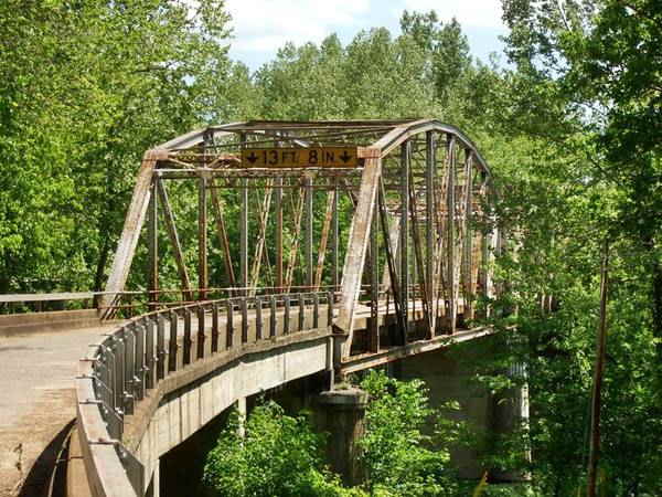
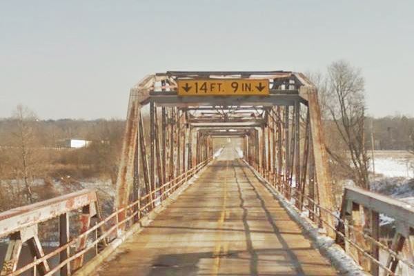
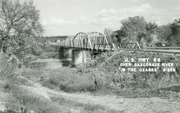
The original steel through-truss bridge predates Route 66, as it was built between 1922 and 1924 (U.S. 66 was created in 1926). It originally carried Missouri State Highway 14 and was designed by the Missouri Highway Department. It has three spans and since the opening of the four-lane highway on Route 66 in the 1950s, was neglected in maintenance and repairs, deteriorating to such an extent that in 2014 it was permanently closed to traffic. A new bridge has been built on the south side of the freeway to carry Route 66 and, as you drive across the river, look left to see the old steel bridge.
View of the Route 66 Gasconade River Bridge today, in Hazelgreen, Missouri
View of the Route 66 Gasconade River Bridge in a vintage postcard in Hazelgreen, Missouri
Lebanon
South of Gasconade River
On the south side of the river, in "Richland", the highway continues westbound towards Lebanon. But the alignment isn't what is now signed as Route 66. Instead, after crossing the bridge, the highway formerly cruved right to the north. Now it is cut by I-44. Then it runs along the north side of the freeway as its frontage road, Hidden Hills Road. After 1.6 miles it heads southwards and is cut nowadays by I-44.
>> green line (the red ones mark the gaps) shows the Richland alignment.
On the south side of the freeway it heads west towards Lebanon as US Route 66. The current Route 66 south of Gasconade bridge to County Rd. N was built after the freeway, as a frontage road.

Route 66 North of Lebanon
At Sleeper
When the highway reaches "Sleeper" it is once again cut off by I-44 just west of Exit 135. Use the overpass at Exit 135 to cross the freeway and head west along its north Frontage Rd. into Lebanon. The map in the image above shows the missing segment with a black line.
>> pink line marks the driveable section from Richland to Sleeper.
>> black line marks the gap at I-44 in Sleeper.
Continue straight westwards into Lebanon.
>> orange line in our custom map shows this alignment into Lebanon.
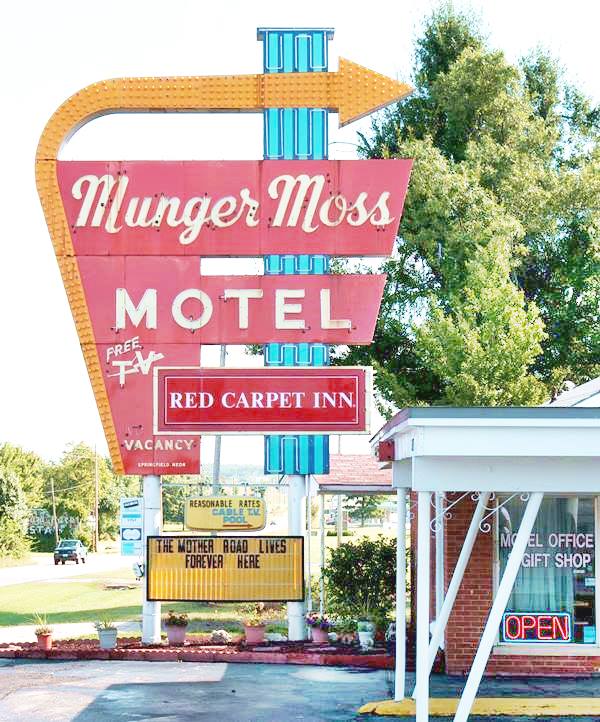
Munger Moss Motel Neon Sign, Lebanon MO
The Shell roadmap below was published in 1958. It shows that in Lebanon, US 66 was a regular 2 lane highway, however, it was a "super-highway" with 4 or more lanes from Stratford to Conway and from Hazelgreen through Waynesville.
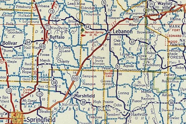
On the south side of Lebanon, the exchange at Exit 127 eliminated the original roadbed, but beyond the exchange the highway continues along the N. Frontage Rd.
Caffeyville Town displaced by 1953 alignment
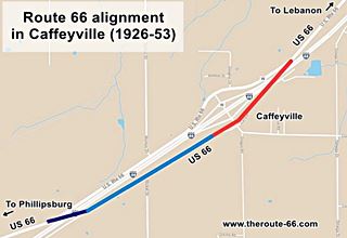
The highway heads west into Caffeyville and the original 1926-53 alignment ran along what is now the N Frontager Rd.
In 1952 the Missouri Highway Department started work to improve Route 66 to make it safer and shorter. It built a completely new road to the east of the original one from Lebanon to Phillipsburg. This highway had four lanes with overpasses. Its construction at Exit 123 led to the removal of most of Caffeyville's buildings. After 1958 it coexisted with I-44 until it was finally delisted around 1979.
The alignment in Caffeyville itself was disrupted by the construction of the four-lane alignment of Route 66 in the 1950s. Then I-44 with interstate roadway standards replaced grade crossings with overpasses.
>> violet line can be driven, red lines mark the gaps in Caffeyville.
This original 1926-50s alignment at Exit 123 is also shown in the image.
Detail of a 1957 Missouri DOT Map south of Lebanon.

The map above shows Route 66 between Lebanon and Springfield in 1957. I-44 had not yet been built and US 66 was a divided highway that almost reached Strafford. The older alignment of Route 66 from Lebanon to Phillipsburg does not even appear in the map, nor does Caffeyville.
Phillipsburg

Route 66 in Phillipsburg
The highway continues into Phillipsburg, where it is cut by I-44 (black line in map). It continues on the south side of the freeway after what is now Exit 118. See this map of US 66 Caffeyville-Phillipsburg.
Phillipsburg, Route 66 1950s realignment
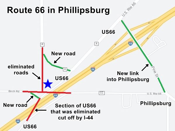
Until the 1950s Birch Rd met US 66 and Co. Rd. A at a junction next to Midway Camp, but, the new four-lane Route 66 and its later upgrade to divided highway with no grade crosssings altered the roads and streets on the western side of Phillipsburg. As you can see in the map below, the segments marked in Red were eliminated, and new roads (Gree) were built to reconnect both sides of the freeway. The Blue star marks the spot where Midway Camp once stood.
>> Blue line in our custom map shows the original US66 with the gap, in Phillipsburg.
Conway, Sampson, Niangua and Marshfield
Drive along the South Frontage Road (County Rd. CC) and head west into Conway, onwards to Sampson and Niangua, to reach Marshfield.
>> red line in custom map shows Conway to Marshfield alignment
Marshfield
Though Rittenhouse in 1946 does not mention a "City 66", and the maps of that time don't have the detail to show the exact alignment through the city, several online references including the city's website mention two different alignments of Route 66 in Marshfield: a City 66 and a Bypass 66.
>> green line in custom map is City 66
1926-1953 Alignment in Red Top
Head west towards Red Top, where US66 curves sharply to the south and back to the north. Rittenhouse in 1946 wrote that the local motel and service station were located at at the summit of a "one-mile, winding grade" for those coming from the east.
Old Route 66 in Strafford

Two Old Maps: USGS 1946 and (inset) 1884 of Strafford Mo.
The two maps in the image, show Strafford in 1884 (written "Stafford" without the first "R"). You can see that it was originally platted on the south side of the railroad. The map also shows two roads -thin black lines. One north of town which was the road that ran next to the telegraph -which was built in 1859 and linked St. Louis with Fort Smith in Arkansas. This road was known as the "Wire Road" it became the main road from Springfield through Strafford to Rolla (now it is State Highway DD).
There was another road from Springfield to St. Louis, shown in the map south of Strafford and it was the main road until the 1860s. The Trail of Tears migration of Indians into Oklahoma followed this road.
Later, the town moved to the north side of the railroad (built in 1870), as shown in the USGS map of 1946.
The town's main street was Pine Street and it became part of a newer highway that ran close to the tracks, from Strafford to Rolla.
>> Red line in our custom map is Route 66 1926-50s alignment from Marshfield to Strafford.
Springfield
>> orange line in custom map shows the 1926-30 US66 into Springfield.
>> violet line in custom map shows the 1930-1977 "City 66" into Springfield.
We describe the road across Springfield in our Route 66 Springfield to Joplin webpage. There were the two alternatives Route 66 followed into the city:
1926-1930 Route 66 into Springfield
Coming from Strafford, towards Springfield the first alignment of Route 66 had a zig-zag alignment with sharp 90° turns. This is the US 66 1926-30 alignment into Springfield
1930-77 Route 66 (City 66) into Springfield
When it was paved around 1930 it was given a new alignment further north and it entered the city along what is now MO-66 and Glenstone Ave. it met the old alignment and went across the city. map of City US 66 in eastern Springfield.
Then it followed the original 1926 alignment through Springfield's downtown area.
Our itinerary from Rolla to Springfield ends here, you can carry on westwards to Joplin and Kansas; see below.

Some sponsored content
> > Book your Hotel in Springfield Missouri.

Credits
Banner image: Hackberry General Store, Hackberry, California by Perla Eichenblat
Jack DeVere Rittenhouse, (1946). A Guide Book to Highway 66.
Route 66 Maps. Missouri D.O.T.


